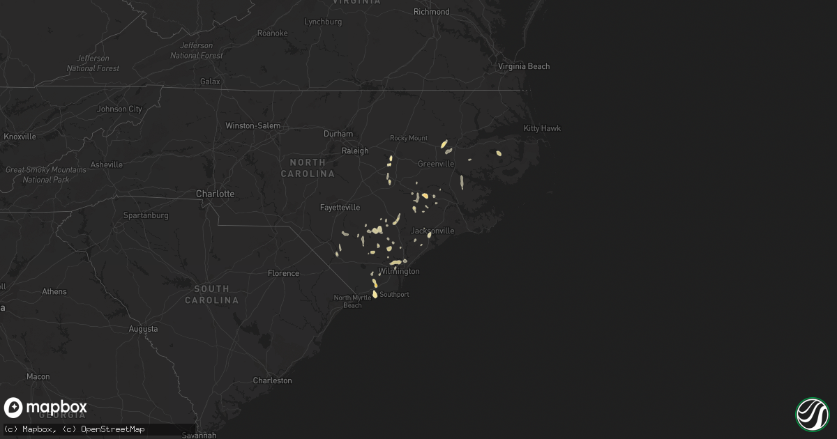
Hail Map in North Carolina on March 25, 2012
Get this storm
March 25 map
$229
one time, instant access
Download today. No call, no setup
Keep the $229
Bought the map and want the full workflow? Apply the entire $229 to a subscription within 7 days. None of it is wasted.
Every map, not just this one
This buys you this map. Subscription and you get every map we run, in the markets you choose from a few cities to whole states to nationwide. Plus real-time alerts the moment a storm fires.
Contact data
Name, contact info, occupancy, even credit band for addresses in the footprint. You go from where it hit to who to call.
Become the source they trust
Unlimited branding weather history reports on demand. You already have the documented answer ready for the property owner, and you are the one who showed up with it.
Property data and RoofTrace estimates
Pull up any address you have got, its value and the exact code rules for that jurisdiction, straight from One Click Code. Then RoofTrace estimates the squares, pitch, and roof value, priced the way you price.
Storm reports in North Carolina
North Carolina
| Date | Description |
|---|---|
| 03/25/20126:10 PM CDT | A local report indicates 1.50 inch wind near HOLDEN BEACH |
| 03/25/20126:05 PM CDT | Fifteen minutes of hail... Covered the ground... Nickel to quarter sized hail. Black-jack church road and knollwood drive |
| 03/25/20126:00 PM CDT | A local report indicates 1.75 inch wind near SUPPLY |
| 03/25/20125:30 PM CDT | A local report indicates 1.75 inch wind near 2 W LUCAMA |
| 03/25/20125:22 PM CDT | A local report indicates 1.50 inch wind near 2 E ROBERSONVILLE |
| 03/25/20125:21 PM CDT | Nickel to quarter size hail in rose hill. |
| 03/25/20123:55 PM CDT | Quarter size hail fell on brooklyn ave in harrells. |
| 03/25/20123:40 PM CDT | Dime to quarter size hail fell from 440 pm to 455 pm. |
| 03/25/20123:10 PM CDT | Law enforcement reported quarter size hail on hwy 74. |
| 03/25/20122:45 PM CDT | Lenior em received calls from west of wyse fork |
| 03/25/20122:35 PM CDT | Dime to quarter size hail fell. |
| 03/25/20122:18 PM CDT | Nickel to quarter size hail still falling...covering the ground. |
| 03/25/20122:05 PM CDT | Pictures of quarter size hail |
| 03/25/20127:48 AM CDT | Quarter hail reported near dan road west of robbins |
All States Impacted by Hail Map on March 25, 2012
Cities Impacted by Hail Map on March 25, 2012
- Jacksonville, NC
- Williamston, NC
- Robersonville, NC
- Kenly, NC
- Lucama, NC
- Sims, NC
- Wilson, NC
- Pink Hill, NC
- Garland, NC
- Rose Hill, NC
- Harrells, NC
- Dover, NC
- Kinston, NC
- Burgaw, NC
- Kelly, NC
- Castle Hayne, NC
- Wilmington, NC
- Leland, NC
- Supply, NC
- Shallotte, NC
- Trenton, NC
- Holly Ridge, NC
- Magnolia, NC
- Kenansville, NC
- Princeton, NC
- Goldsboro, NC
- Pikeville, NC
- Elizabethtown, NC
- Council, NC
- Currie, NC
- Pinetown, NC
- Ivanhoe, NC
- Willard, NC
- Riegelwood, NC
- Tar Heel, NC
- Creswell, NC
- Columbia, NC
- Maple Hill, NC
- Atkinson, NC
- Blounts Creek, NC
- Chocowinity, NC
- Ash, NC
- Lumberton, NC
- Bladenboro, NC
- Evergreen, NC
- Snow Hill, NC
- La Grange, NC
- Deep Run, NC
- Cove City, NC
- Clinton, NC


