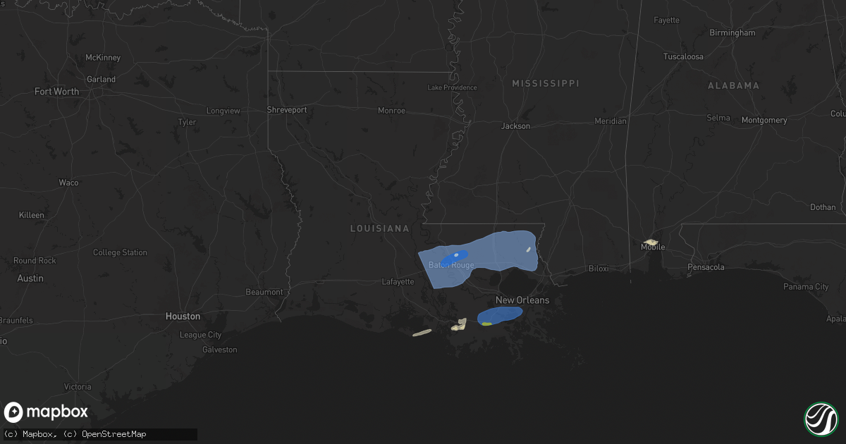
Hail Map in Louisiana on March 24, 2025
Get this storm
March 24 map
$229
one time, instant access
Download today. No call, no setup
Keep the $229
Bought the map and want the full workflow? Apply the entire $229 to a subscription within 7 days. None of it is wasted.
Every map, not just this one
This buys you this map. Subscription and you get every map we run, in the markets you choose from a few cities to whole states to nationwide. Plus real-time alerts the moment a storm fires.
Contact data
Name, contact info, occupancy, even credit band for addresses in the footprint. You go from where it hit to who to call.
Become the source they trust
Unlimited branding weather history reports on demand. You already have the documented answer ready for the property owner, and you are the one who showed up with it.
Property data and RoofTrace estimates
Pull up any address you have got, its value and the exact code rules for that jurisdiction, straight from One Click Code. Then RoofTrace estimates the squares, pitch, and roof value, priced the way you price.
Storm reports in Louisiana
Louisiana
| Date | Description |
|---|---|
| 03/24/202510:30 AM CDT | Picture on social media from local broadcast meteorologist showed hail stone around quarter to half dollar size reported near bayou blue. |
| 03/24/202510:14 AM CDT | Parish em shared video showing pea to quarter size hail at terrebonne parish sheriffs office rifle range on savanne road. |
| 03/24/20259:01 AM CDT | Big branches broken off trees and minor flooding on doyle melancon road. |
| 03/24/20259:00 AM CDT | The i-12 exit sign for la highway 434 lacombe was blown over by thunderstorm winds. |
| 03/24/20258:15 AM CDT | Parish s.o. Reported tree down off wardline rd before hebert-kyzar rd. |
| 03/24/20258:15 AM CDT | Parish s.o. Reported tree fell on house at 49000 block of whiskey lane. |
| 03/24/20258:10 AM CDT | Parish s.o. Reported tree down at pumpkin center rd in front of trinity baptist church. Time estimated by radar. |
| 03/24/20258:00 AM CDT | Broadcast media posted a picture of a tree downed by thunderstorm winds on mack road north of walker. |
| 03/24/20257:55 AM CDT | Father of nws employee reported a tree down in neighbors yard and leaves plastered to his shop wall 23 feet high due to thunderstorm winds. This was off wax road in cen |
| 03/24/20257:24 AM CDT | Asos station kbtr baton rouge airport. |
| 03/24/20257:10 AM CDT | Tree and power lines downed on maringouin road east. |
All States Impacted by Hail Map on March 24, 2025
Cities Impacted by Hail Map on March 24, 2025
- Guin, AL
- Winfield, AL
- Brilliant, AL
- Eldridge, AL
- Nauvoo, AL
- Beaverton, AL
- Sulligent, AL
- Detroit, AL
- Smithville, MS
- Amory, MS
- Greenwood Springs, MS
- Sulphur, LA
- Vinton, LA
- Hackberry, LA
- Grosse Tete, LA
- Maringouin, LA
- Fordoche, LA
- Livonia, LA
- Lottie, LA
- Plaquemine, LA
- Saint Martinville, LA
- Port Allen, LA
- Jarreau, LA
- New Roads, LA
- Ventress, LA
- Oscar, LA
- Rosedale, LA
- White Castle, LA
- Addis, LA
- Sunshine, LA
- Glynn, LA
- Rougon, LA
- Erwinville, LA
- Brusly, LA
- Lakeland, LA
- Carville, LA
- Baton Rouge, LA
- Jackson, LA
- Zachary, LA
- Saint Gabriel, LA
- Prairieville, LA
- Gonzales, LA
- Geismar, LA
- Donaldsonville, LA
- Slaughter, LA
- Baker, LA
- Greenwell Springs, LA
- Denham Springs, LA
- Livingston, LA
- Pride, LA
- Walker, LA
- Clinton, LA
- Holden, LA
- Pine Grove, LA
- Semmes, AL
- Springfield, LA
- Hammond, LA
- Albany, LA
- Ponchatoula, LA
- Greensburg, LA
- Independence, LA
- Tickfaw, LA
- Amite, LA
- Kentwood, LA
- Fluker, LA
- Roseland, LA
- Loranger, LA
- Robert, LA
- Husser, LA
- Franklinton, LA
- Folsom, LA
- Mount Hermon, LA
- Covington, LA
- Madisonville, LA
- Mobile, AL
- Eight Mile, AL
- Mandeville, LA
- Abita Springs, LA
- Angie, LA
- Bogalusa, LA
- Bush, LA
- Lacombe, LA
- Daphne, AL
- Slidell, LA
- Carriere, MS
- Pearl River, LA
- Picayune, MS
- Poplarville, MS
- Franklin, LA
- Donner, LA
- Schriever, LA
- Gibson, LA
- Houma, LA
- Raceland, LA
- Lockport, LA
- Thibodaux, LA
- Gray, LA
- Mathews, LA
- Gheens, LA
- Des Allemands, LA
- Ama, LA
- Lafitte, LA
- Westwego, LA
- Marrero, LA
- Paradis, LA
- Boutte, LA
- Belle Chasse, LA
- Harvey, LA
- Morgan City, LA
- Fort Pierce, FL


