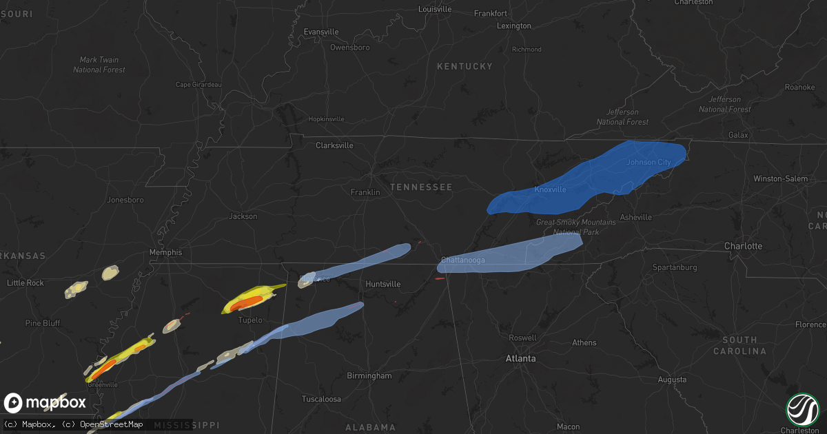
Hail Map in Tennessee on March 24, 2023
Get this storm
March 24 map
$229
one time, instant access
Download today. No call, no setup
Keep the $229
Bought the map and want the full workflow? Apply the entire $229 to a subscription within 7 days. None of it is wasted.
Every map, not just this one
This buys you this map. Subscription and you get every map we run, in the markets you choose from a few cities to whole states to nationwide. Plus real-time alerts the moment a storm fires.
Contact data
Name, contact info, occupancy, even credit band for addresses in the footprint. You go from where it hit to who to call.
Become the source they trust
Unlimited branding weather history reports on demand. You already have the documented answer ready for the property owner, and you are the one who showed up with it.
Property data and RoofTrace estimates
Pull up any address you have got, its value and the exact code rules for that jurisdiction, straight from One Click Code. Then RoofTrace estimates the squares, pitch, and roof value, priced the way you price.
Storm reports in Tennessee
Tennessee
| Date | Description |
|---|---|
| 03/24/20234:30 AM CDT | County dispatch reported a tree down along highway 67w. Time estimated by radar. |
| 03/24/20234:15 AM CDT | County dispatch reports tree on house on garfield street in unicoi. Time estimated by radar. |
| 03/24/20234:00 AM CDT | Reported from cove mountain wind tower. |
| 03/24/20233:40 AM CDT | Trees down and minor property damage due to severe winds. |
| 03/24/20233:39 AM CDT | Trained spotter reports a measured 67 mph gust on a home weather station. |
| 03/24/20233:35 AM CDT | County dispatch reports multiple trees down located across the county. |
| 03/24/20233:30 AM CDT | County dispatch reported large tree down on gap creek road... As well as multiple trees down in the county. Power company had reported power outages to dispatch. |
| 03/24/20233:15 AM CDT | County dispatch reports a tree down in bean station. Time estimated by radar. |
| 03/24/20233:10 AM CDT | County dispatch reports trees down in several locations county wide. Time estimated by radar. |
| 03/24/20232:50 AM CDT | County dispatch reports a tree down in blaine. Time estimated by radar. |
| 03/24/20232:45 AM CDT | County dispatch reports trees down county wide. Time estimate from radar. |
| 03/24/20232:44 AM CDT | A 63 mph wind gust measured on a home weather station was recorded by a trained spotter. |
| 03/24/20232:43 AM CDT | Trained spotter measured a 74 mph wind gust. |
| 03/24/20232:42 AM CDT | Knoxville mcghee tyson airport asos recorded a 70 mph wind gust. |
| 03/24/20232:35 AM CDT | County dispatch reported tree down on state route 39 near the county line. Time estimated by radar. |
| 03/24/20232:30 AM CDT | County dispatch reports power lines down in etowah city. Time estimated by radar. |
| 03/24/20232:25 AM CDT | County dispatch reports lots of trees down county wide. |
| 03/24/20232:15 AM CDT | A trained spotter recorded a 63 mph wind gust along the paul huff parkway in cleveland tn. |
| 03/24/20231:56 AM CDT | Chattanooga asos recorded a 65 mph wind gust. |
| 03/24/20231:55 AM CDT | Power pole broken in two with power lines down. Time estimated by radar. |
| 03/24/20231:54 AM CDT | Report from cocorahs observer ms-1 near ten mile. Time estimated from radar. |
| 03/24/20231:50 AM CDT | Sandswitch road in hixson closed due to trees down in several places. Time estimated by radar. From social media. |
| 03/24/20231:50 AM CDT | Trees down near intersection of knollwood drive and thrushwood in chattanooga. From social media. Time estimated from radar. |
| 03/24/20231:48 AM CDT | Trees and power lines down on redding road... Also berkeley drive in red bank with trees blocking that road. Tree blocking hunter trail 2 miles ne of red bank. Several |
| 03/24/20231:48 AM CDT | Several trees down on west 12th street in downtown chattanooga. Time estimated from radar. From social media. |
| 03/24/20231:30 AM CDT | Multiple reports of trees down across marion county. Time estimated by radar. |
| 03/24/20231:27 AM CDT | Large trees blown over around the lakeview drive area. |
| 03/24/20231:25 AM CDT | County dispatch reports power lines down and tree branches down near bledsoe county middle school. Time estimated by radar. |
| 03/24/20231:15 AM CDT | County dispatch reports multiple trees down throughout the county... With a concentration along and near state route 28. Time estimated by radar. |
| 03/24/202312:00 AM CDT | Damage reported at the hospital in fayetteville. Multiple trees reported down as well. Possible tornado. |
| 03/23/202311:40 PM CDT | Thunderstorm wind damage in giles county including downed tree limbs and shingles blown off roof. |
| 03/23/202311:00 PM CDT | At smyrna high school... A light pole on the visitor side of the stadium was blown down and damaged several cars at the apartments next door. Nobody was injured. |
| 03/23/202311:00 PM CDT | Large cedar tree blown down. |
| 03/23/202310:53 PM CDT | Tree fell on house on youngs lane near trinity lane in north nashville. |
| 03/23/202310:51 PM CDT | *** 1 inj *** tree down on house on bess court north off of ocala drive in southeast davidson county. One minor injury reported. |
| 03/23/202310:50 PM CDT | #tspotter report of a large tree downed in mcferrin park. Time is estimated based on radar. |
| 03/23/202310:47 PM CDT | Chicken coop damaged and 2 large trees blown down along burke hollow rd. |
| 03/23/202310:40 PM CDT | Large tree downed and blocking the road near the intersection of harding pike and white bridge road in belle meade. Time is estimated based on radar. |
| 03/23/202310:17 PM CDT | Trees and power lines down. |
| 03/23/202310:16 PM CDT | Property and structure damage at new holland tractor. |
| 03/23/202310:12 PM CDT | Tree down blocking the road at glen raven road and carr road near adams. |
| 03/23/202310:08 PM CDT | Large billboard and street address signs blown down. |
| 03/23/202310:08 PM CDT | Large billboard blown down and street address sign blown down at tn sr 46 and lewis hollow rd. |
| 03/23/20239:42 PM CDT | Trees down and some damage to shops. |
| 03/23/20239:42 PM CDT | Trees down along hwy 13. |
| 03/23/20239:25 PM CDT | #tspotter report with numerous trees downed at a residence in lobelville with one tree reported to have fallen on the house and another on a car. Time is estimated base |
| 03/23/20239:24 PM CDT | House damaged and barn blown away. |
| 03/23/20239:09 PM CDT | Corrects previous tstm wnd dmg report from 5 s bargerton. Report of power lines down with pole damage in the 500-600 block of sand ridge road. |
| 03/23/20239:05 PM CDT | Trees down and power lines on road. |
| 03/23/20238:58 PM CDT | Trees down and a fence blown down. |
| 03/23/20238:58 PM CDT | Reports of trees down. |
| 03/23/20237:40 PM CDT | One large tree snapped at base with smaller limbs down around it. |
| 03/23/20237:39 PM CDT | Asos station kmem memphis. |
All States Impacted by Hail Map on March 24, 2023
Cities Impacted by Hail Map on March 24, 2023
- Emory, TX
- Alba, TX
- Yantis, TX
- Ivanhoe, TX
- Telephone, TX
- Point, TX
- Pittsburg, TX
- Mount Pleasant, TX
- Scroggins, TX
- Leesburg, TX
- Simsboro, LA
- Charleston, MS
- Tutwiler, MS
- Drew, MS
- Rolling Fork, MS
- Anguilla, MS
- Mayersville, MS
- Cleveland, MS
- Greenville, MS
- Boyle, MS
- Benoit, MS
- Dermott, AR
- Parchman, MS
- Lake Village, AR
- Sumner, MS
- Beulah, MS
- Merigold, MS
- Belzoni, MS
- Silver City, MS
- Louise, MS
- Tchula, MS
- Enid, MS
- Pope, MS
- Cruger, MS
- Lexington, MS
- Coila, MS
- Winona, MS
- Thaxton, MS
- Pontotoc, MS
- New Albany, MS
- Ecru, MS
- Blue Springs, MS
- Guntown, MS
- Saltillo, MS
- Baldwyn, MS
- Dumas, MS
- Booneville, MS
- Marietta, MS
- New Site, MS
- Tishomingo, MS
- Sparkman, AR
- Bienville, LA
- Stuttgart, AR
- Rohwer, AR
- Marianna, AR
- Moro, AR
- Haynes, AR
- Forrest City, AR
- Goodwin, AR
- Palestine, AR
- Roe, AR
- De Valls Bluff, AR
- Batesville, MS
- Oakland, MS
- Courtland, MS
- Shaw, MS
- Wesson, MS
- Hazlehurst, MS
- Arkadelphia, AR
- Ruleville, MS
- Clarendon, AR
- Ulm, AR
- Hazen, AR
- Farmerville, LA
- Lake Providence, LA
- Hamburg, AR
- Montrose, AR
- Crossett, AR
- McGehee, AR
- Arkansas City, AR
- Hollandale, MS
- Iuka, MS
- Okolona, MS
- Aberdeen, MS
- Amory, MS
- Smithville, MS
- Fulton, MS
- Hodges, AL
- Killen, AL
- Hamilton, AL
- Tuscumbia, AL
- Spruce Pine, AL
- Muscle Shoals, AL
- Vina, AL
- Tremont, MS
- Russellville, AL
- Detroit, AL
- Hackleburg, AL
- Bear Creek, AL
- Haleyville, AL
- Athens, AL
- Florence, AL
- Rogersville, AL
- Sheffield, AL
- Lexington, AL
- Anderson, AL
- Lester, AL
- Elkmont, AL
- Double Springs, AL
- Houston, AL
- Moulton, AL
- Danville, AL
- Prospect, TN
- Minor Hill, TN
- Ardmore, AL
- Ardmore, TN
- Toney, AL
- Fayetteville, TN
- Dellrose, TN
- Taft, TN
- Kelso, TN
- Mulberry, TN
- Belvidere, TN
- Flintville, TN
- Hazel Green, AL
- Elora, TN
- Phil Campbell, AL
- Lynchburg, TN
- Winchester, TN
- Estill Springs, TN
- Huntland, TN
- Tullahoma, TN
- Decherd, TN
- Hartselle, AL
- Falkville, AL
- Addison, AL
- Decatur, AL
- Grant, AL
- Flat Rock, AL
- Higdon, AL
- McDonald, TN
- Bryant, AL
- Trenton, GA
- Jasper, TN
- Lookout Mountain, TN
- Bridgeport, AL
- Fort Oglethorpe, GA
- Lookout Mountain, GA
- Whiteside, TN
- Flintstone, GA
- Chickamauga, GA
- Rising Fawn, GA
- Wildwood, GA
- Ringgold, GA
- Dalton, GA
- Cohutta, GA
- Chattanooga, TN
- Tunnel Hill, GA
- Stevenson, AL
- Whitwell, TN
- Apison, TN
- Rossville, GA
- Guild, TN
- Ooltewah, TN
- South Pittsburg, TN
- Harrison, TN
- Cleveland, TN
- Lupton City, TN
- Crandall, GA
- Cisco, GA
- Chatsworth, GA
- Old Fort, TN
- Ocoee, TN
- Benton, TN
- Reliance, TN
- Cherry Log, GA
- Epworth, GA
- Blue Ridge, GA
- McCaysville, GA
- Copperhill, TN
- Turtletown, TN
- Farner, TN
- Murphy, NC
- Mineral Bluff, GA
- Morganton, GA
- Grandview, TN
- Loudon, TN
- Kingston, TN
- Spring City, TN
- Rockwood, TN
- Philadelphia, TN
- Ten Mile, TN
- Harriman, TN
- Oak Ridge, TN
- Lenoir City, TN
- Knoxville, TN
- Farragut, TN
- Louisville, TN
- Friendsville, TN
- Maryville, TN
- Alcoa, TN
- Rockford, TN
- Seymour, TN
- Sevierville, TN
- Strawberry Plains, TN
- Walland, TN
- Kodak, TN
- Greenback, TN
- Pigeon Forge, TN
- New Market, TN
- Dandridge, TN
- Tellico Plains, TN
- Blairsville, GA
- Brasstown, NC
- Charleston, TN
- Marble, NC
- Delano, TN
- Robbinsville, NC
- Hixson, TN
- Sweetwater, TN
- Townsend, TN
- Gatlinburg, TN
- Tallassee, TN
- Andrews, NC
- Bryson City, NC
- Topton, NC
- Hayesville, NC
- Cosby, TN
- Newport, TN
- White Pine, TN
- Talbott, TN
- Jefferson City, TN
- Morristown, TN
- Mohawk, TN
- Parrottsville, TN
- Bybee, TN
- Midway, TN
- Mosheim, TN
- Greeneville, TN
- Del Rio, TN
- Woodland, MS
- Gore Springs, MS
- Eupora, MS
- Bellefontaine, MS
- Calhoun City, MS
- Stewart, MS
- Duck Hill, MS
- Cherokee, AL
- Houston, MS
- Mantee, MS
- West Point, MS
- Prairie, MS
- Dennis, MS
- Almond, NC
- Franklin, NC
- Afton, TN
- Russellville, TN
- Whitesburg, TN
- Hot Springs, NC
- Marshall, NC
- Bulls Gap, TN
- Chuckey, TN
- Limestone, TN
- Powell, TN
- Mascot, TN
- Blaine, TN
- Corryton, TN
- Bean Station, TN
- Mooresburg, TN
- Rutledge, TN
- Rogersville, TN
- Surgoinsville, TN
- Church Hill, TN
- Mount Carmel, TN
- Kingsport, TN
- Fall Branch, TN
- Blountville, TN
- Jonesborough, TN
- Johnson City, TN
- Telford, TN
- Flag Pond, TN
- Erwin, TN
- Bristol, TN
- Unicoi, TN
- Bluff City, TN
- Piney Flats, TN
- Watauga, TN
- Elizabethton, TN
- Hampton, TN
- Butler, TN
- Roan Mountain, TN
- Mountain City, TN
- Shady Valley, TN
- Sugar Grove, NC
- Elk Park, NC
- Vilas, NC
- Zionville, NC
- Trade, TN
- Mathiston, MS
- Maben, MS
- Greenwood Springs, MS
- Sulligent, AL
- Beaverton, AL
- Guin, AL
- Brilliant, AL
- Vaiden, MS
- Kilmichael, MS
- Andalusia, AL
- Oxford, MS


