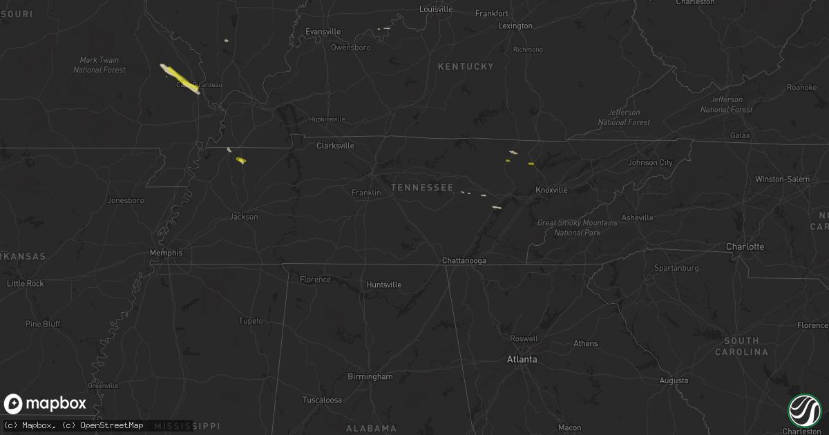
Hail Map in Tennessee on March 24, 2018
Get this storm
March 24 map
$229
one time, instant access
Download today. No call, no setup
Keep the $229
Bought the map and want the full workflow? Apply the entire $229 to a subscription within 7 days. None of it is wasted.
Every map, not just this one
This buys you this map. Subscription and you get every map we run, in the markets you choose from a few cities to whole states to nationwide. Plus real-time alerts the moment a storm fires.
Contact data
Name, contact info, occupancy, even credit band for addresses in the footprint. You go from where it hit to who to call.
Become the source they trust
Unlimited branding weather history reports on demand. You already have the documented answer ready for the property owner, and you are the one who showed up with it.
Property data and RoofTrace estimates
Pull up any address you have got, its value and the exact code rules for that jurisdiction, straight from One Click Code. Then RoofTrace estimates the squares, pitch, and roof value, priced the way you price.
Storm reports in Tennessee
Tennessee
| Date | Description |
|---|---|
| 03/24/20186:52 PM CDT | A few trees down near claude tucker road. Also... An above-ground pool flipped over onto a privacy fence in the same area. Time is radar estimated. |
| 03/24/20185:30 PM CDT | Time estimated by radar. |
| 03/24/20185:14 PM CDT | Media photo from near robbins of estimated quarter size hail. Time estimated by radar. |
| 03/24/20183:45 AM CDT | At 845 PM CDT, a severe thunderstorm was located near Wildersville, or 8 miles northwest of Natchez Trace State Park, moving southeast at 25 mph. HAZARD...60 mph wind gusts. SOURCE...Radar indicated. IMPACT...Expect damage to roofs, siding, and trees. Locations impacted include... Lexington, Natchez Trace State Park, Natchez Trace State Forest, Parsons, Decaturville, Parkers Crossroads, Darden, Wildersville, Scotts Hill, Clarksburg, Howley, Busseltown, Jeannette, Rock Hill, Union Cross, Mount Tabor, Timberlake, Cozette, Westport and Parker's Cross Roads. |
| 03/24/20183:00 AM CDT | At 800 PM CDT, a severe thunderstorm was located near Atwood, or 10 miles north of Milan, moving southeast at 35 mph. HAZARD...60 mph wind gusts. SOURCE...Radar indicated. IMPACT...Expect damage to roofs, siding, and trees. Locations impacted include... Huntingdon, Bradford, Atwood, Parkers Crossroads, Bargerton, Trezevant, Clarksburg, McLemoresville, Howley, Hickory Flat, Hillard, Union Cross, Leach, Staffords Store, Tate, Palmer Shelter, Gann, Wingo, Westport and Parker's Cross Roads. |
| 03/24/20181:11 AM CDT | At 610 PM EDT, a severe thunderstorm was located over Huntsville, or near Oneida, moving east at 50 mph. HAZARD...60 mph wind gusts and quarter size hail. SOURCE...Radar indicated. IMPACT...Hail damage to vehicles is expected. Expect wind damage to roofs, siding, and trees. Locations impacted include... La Follette, Jacksboro, Huntsville, Caryville, Lake City, Norris, Norris Dam State Park, Smokey Junction, Disney, Cove Lake State Park, Fincastle, Royal Blue, Norma and Slick Rock. |
| 03/23/20187:29 PM CDT | Quarter sized hail and winds estimated around 50 mph. |
Cities Impacted by Hail Map on March 24, 2018
- Cape Girardeau, MO
- Scott City, MO
- Martin, TN
- Spring City, TN
- Grandview, TN
- Marquand, MO
- Patton, MO
- Marble Hill, MO
- Crossville, TN
- Whitewater, MO
- Sedgewickville, MO
- Millersville, MO
- Burfordville, MO
- Sparta, TN
- Derby, IN
- Chaffee, MO
- Jackson, MO
- Carterville, IL
- Union City, TN
- Helenwood, TN
- Huntsville, TN
- Tell City, IN
- Robbins, TN
- Caryville, TN


