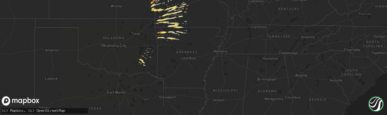
Hail Map in Arkansas on March 24, 2015
The weather event in Arkansas on March 24, 2015 includes Hail map. 5 states and 257 cities were impacted and suffered possible damage. The total estimated number of properties impacted is 94,980.
Want more than just the map?
Turn this storm into a full workflow.
- Owner + property data so you know who to knock
- OnDemand branded weather history reports to win the "did we even have hail?" argument
- RoofTrace estimate so reps stop guessing numbers at the door
Bought this map? Upgrade within 7 days and we'll credit the $230. (10-15 min setup call)
Hail
94,980
Estimated number of impacted properties by a 1.00" hail or larger42,759
Estimated number of impacted properties by a 1.75" hail or larger0
Estimated number of impacted properties by a 2.50" hail or largerStorm reports in Arkansas
Arkansas
| Date | Description |
|---|---|
| 03/24/20156:54 PM CDT | A local report indicates 1.00 inch wind near 1 N OMAHA |
| 03/24/20156:24 PM CDT | A local report indicates 1.00 inch wind near WEST FORK |
| 03/24/20156:16 PM CDT | A local report indicates 2.00 inch wind near LOWELL |
| 03/24/20156:16 PM CDT | South of lincoln on sugar hill cutoff. |
| 03/24/20156:16 PM CDT | On beaver lake near hickory creek. |
| 03/24/20156:16 PM CDT | A local report indicates 1.50 inch wind near SPRINGDALE |
| 03/24/20156:16 PM CDT | A local report indicates 1.00 inch wind near 4 S PRAIRIE GROVE |
| 03/24/20156:16 PM CDT | 1.5 inch hail at bethel heights |
| 03/24/20156:10 PM CDT | A local report indicates 1.75 inch wind near SPRINGDALE |
| 03/24/20156:10 PM CDT | Quarter size hail in spring valley. |
| 03/24/20156:08 PM CDT | Quarter hail between nelson hollow and hickory creek. |
| 03/24/20156:05 PM CDT | 1.5 inch hail in bethel heights. |
| 03/24/20156:02 PM CDT | Golfball hail at exit 76 on i-49 in benton county near lowell. |
| 03/24/20156:00 PM CDT | A local report indicates 1.25 inch wind near SONORA |
| 03/23/20158:40 PM CDT | A local report indicates 1.00 inch wind near 2 SW YELLVILLE |
| 03/23/20158:00 PM CDT | Half dollar size hail in harrison arkansas. |
| 03/23/20157:35 PM CDT | A local report indicates 1.00 inch wind near 1 SE VALLEY SPRINGS |
| 03/23/20157:22 PM CDT | A local report indicates 1.00 inch wind near GAITHER |
Cities Impacted by Hail Map on March 24, 2015
- Hughesville, MO
- Leeton, MO
- Windsor, MO
- Sedalia, MO
- Knob Noster, MO
- Chilhowee, MO
- La Monte, MO
- Antlers, OK
- Clayton, OK
- Mount Vernon, IL
- Woodlawn, IL
- Ashley, IL
- Waltonville, IL
- Du Bois, IL
- Nixa, MO
- Ozark, MO
- Springdale, AR
- Lowell, AR
- Mansfield, MO
- Fordland, MO
- Seymour, MO
- Kingston, AR
- Witter, AR
- Deer, AR
- Saint Paul, AR
- Mount Judea, AR
- Pettigrew, AR
- Ponca, AR
- Aurora, MO
- Goodman, MO
- Cassville, MO
- Stella, MO
- Anderson, MO
- Fairview, MO
- Exeter, MO
- Purdy, MO
- Butterfield, MO
- Verona, MO
- Rocky Comfort, MO
- Neosho, MO
- Wheaton, MO
- Holden, MO
- Blairstown, MO
- Half Way, MO
- Cape Fair, MO
- Taneyville, MO
- Reeds Spring, MO
- Walnut Shade, MO
- Rockaway Beach, MO
- Galena, MO
- Branson, MO
- Forsyth, MO
- Brighton, MO
- Willard, MO
- Bolivar, MO
- Morrisville, MO
- Rogersville, MO
- Arma, KS
- Girard, KS
- Odessa, MO
- Bates City, MO
- Clever, MO
- Billings, MO
- Marionville, MO
- Franklin, KS
- Pierce City, MO
- Monett, MO
- Red Oak, OK
- Wilburton, OK
- Fulton, KS
- Fort Scott, KS
- Moundville, MO
- Nevada, MO
- Whiteman Air Force Base, MO
- Clinton, MO
- Warrensburg, MO
- Blue Eye, MO
- Lampe, MO
- Shell Knob, MO
- Hollister, MO
- Yellville, AR
- Concordia, MO
- Seligman, MO
- Washburn, MO
- Granby, MO
- Waverly, MO
- Corder, MO
- Mayview, MO
- Alma, MO
- Garden City, MO
- Kingsville, MO
- Centerview, MO
- Higginsville, MO
- Lebanon, MO
- Stoutland, MO
- Adrian, MO
- Ozark, AR
- Aldrich, MO
- Green Forest, AR
- Berryville, AR
- Niangua, MO
- Strafford, MO
- Springfield, MO
- Marshfield, MO
- Fair Grove, MO
- Prairie Grove, AR
- Pleasanton, KS
- Urbana, MO
- West Fork, AR
- Winslow, AR
- Lincoln, AR
- Elkins, AR
- Canehill, AR
- Fayetteville, AR
- Buffalo, MO
- Dadeville, MO
- Greenfield, MO
- Walnut Grove, MO
- Pleasant Hope, MO
- Fair Play, MO
- Everton, MO
- Harrison, AR
- Kirbyville, MO
- Foster, MO
- Creighton, MO
- Butler, MO
- Archie, MO
- Hume, MO
- Rogers, AR
- Jamestown, MO
- California, MO
- Conway, MO
- Grovespring, MO
- Westphalia, MO
- Jefferson City, MO
- Stark City, MO
- Prescott, KS
- Rich Hill, MO
- Redfield, KS
- Snow, OK
- Rattan, OK
- Montrose, MO
- Urich, MO
- Osceola, MO
- Collins, MO
- Hartshorne, OK
- Eldridge, MO
- Richland, MO
- Asbury, MO
- Mindenmines, MO
- Oronogo, MO
- Pittsburg, KS
- Lamar, MO
- Golden City, MO
- Liberal, MO
- Jasper, MO
- Lockwood, MO
- Frontenac, KS
- Mulberry, KS
- Freeburg, MO
- Linn, MO
- Saint Thomas, MO
- Phillipsburg, MO
- Long Lane, MO
- Mountain Home, AR
- Scheller, IL
- Protem, MO
- Peel, AR
- Cedarcreek, MO
- Omaha, AR
- Lead Hill, AR
- Ash Grove, MO
- Bois D Arc, MO
- Kimberling City, MO
- Golden, MO
- Ridgedale, MO
- Russellville, MO
- Dunnegan, MO
- Kissee Mills, MO
- Everton, AR
- Arcadia, KS
- Farlington, KS
- Garland, KS
- Hepler, KS
- Bronaugh, MO
- Deerfield, MO
- Witts Springs, AR
- Malta Bend, MO
- Hindsville, AR
- Hartville, MO
- Oakland, AR
- Powersite, MO
- Theodosia, MO
- Bradleyville, MO
- Eagle Rock, MO
- Elkland, MO
- Tunas, MO
- Windyville, MO
- El Dorado Springs, MO
- Stockton, MO
- Pittsburg, OK
- Huntsville, AR
- Alpena, AR
- Western Grove, AR
- Talihina, OK
- Mount Vernon, MO
- La Russell, MO
- Sarcoxie, MO
- Miller, MO
- Stotts City, MO
- Eugene, MO
- Pyatt, AR
- Flippin, AR
- Marshall, MO
- Nelson, MO
- Richards, MO
- Schell City, MO
- Norfork, AR
- Compton, AR
- Mccurtain, OK
- Thornfield, MO
- Noble, MO
- Seneca, MO
- Daisy, OK
- Stigler, OK
- Combs, AR
- Shady Point, OK
- Bokoshe, OK
- Laquey, MO
- Wister, OK
- Denton, KS
- Bendena, KS
- Flemington, MO
- Gainesville, MO
- Carthage, MO
- Quincy, MO
- Overbrook, KS
- Kinta, OK
- Reeds, MO
- Ava, MO
- Walker, MO
- Wasola, MO
- Drury, MO
- Blackwater, MO
- Houstonia, MO
- Brixey, MO
- Lynchburg, MO
- Falcon, MO
- Cotter, AR
- Keota, OK
- Gentry, AR
- Cave Springs, AR
- Siloam Springs, AR
- Bentonville, AR
- Oak Grove, AR
- Loose Creek, MO
- Green Ridge, MO


