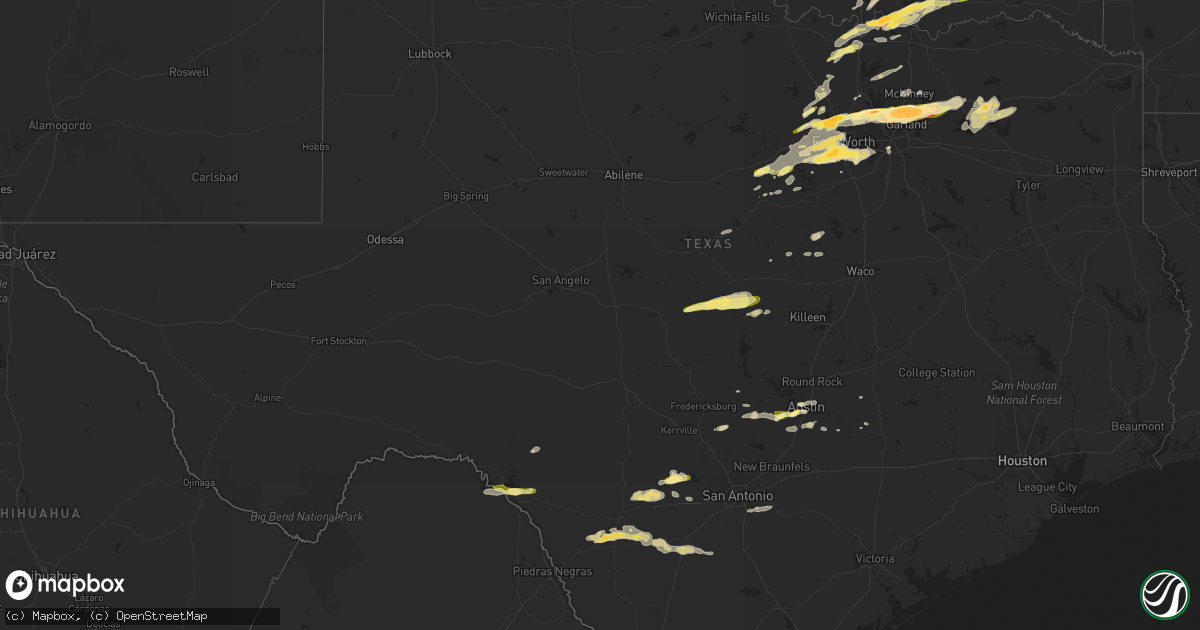
Hail Map in Texas on March 23, 2016
Get this storm
March 23 map
$229
one time, instant access
Download today. No call, no setup
Keep the $229
Bought the map and want the full workflow? Apply the entire $229 to a subscription within 7 days. None of it is wasted.
Every map, not just this one
This buys you this map. Subscription and you get every map we run, in the markets you choose from a few cities to whole states to nationwide. Plus real-time alerts the moment a storm fires.
Contact data
Name, contact info, occupancy, even credit band for addresses in the footprint. You go from where it hit to who to call.
Become the source they trust
Unlimited branding weather history reports on demand. You already have the documented answer ready for the property owner, and you are the one who showed up with it.
Property data and RoofTrace estimates
Pull up any address you have got, its value and the exact code rules for that jurisdiction, straight from One Click Code. Then RoofTrace estimates the squares, pitch, and roof value, priced the way you price.
Storm reports in Texas
Texas
| Date | Description |
|---|---|
| 03/23/20162:58 AM CDT | Nickel to quarter size hail |
| 03/23/20162:45 AM CDT | A number of residential fences blown down by high winds |
| 03/23/20162:35 AM CDT | Trees down along highway 80 near marshall. Other large tree limbs downed as well. |
| 03/23/20162:25 AM CDT | Numerous trees down along interstate 20 from near exit 604 near hallsville east to exit 615 near marshall. |
| 03/23/20162:25 AM CDT | Power line down across highway 59 just south of the jefferson city limits. |
| 03/23/20162:18 AM CDT | Trees down on cr 1619 near the cass/marion county line. |
| 03/23/20162:07 AM CDT | A local report indicates 67 MPH wind near AUSTIN BERGSTROM INT AP |
| 03/23/20162:05 AM CDT | Emergency manager reported tree limbs down near hwy 21 and us 183. Time estimated from radar. |
| 03/23/20161:55 AM CDT | Golf ball sized hail was reported at hwy 290 and mopac in southwest austin. |
| 03/23/20161:45 AM CDT | Several trees down in gilmer. |
| 03/23/20161:40 AM CDT | Large 10 to 12 inch diameter oak tree limbs blown onto vehicle near woodcreek dr and marina circle just northwest of wimberley |
| 03/23/20161:29 AM CDT | Multiple snapped and downed trees were reported in the marina circle area of wimberley. |
| 03/23/20161:05 AM CDT | Trees down near the intersection of cr 4030 and cr 4025. |
| 03/23/20161:04 AM CDT | 60 mph winds estimated by blanco ems employee |
| 03/23/201612:15 AM CDT | Ping pong size hail in brashear |
| 03/23/201612:01 AM CDT | Quarter sized hail was reported at san pedro estates near lake amistad. |
| 03/22/201610:50 PM CDT | A local report indicates 1.00 inch wind near 7 NE SAN SABA |
| 03/22/201610:45 PM CDT | Ping pong size hail estimated in the city of murphy... With mixed in smaller sizes. |
| 03/22/201610:45 PM CDT | Golfball and ping pong ball size hail at wylie/murphy border |
| 03/22/201610:41 PM CDT | Golfball sized hail 2 nne of plano |
| 03/22/201610:40 PM CDT | Northern portions of garland |
| 03/22/201610:37 PM CDT | Reported on scott drive in sachse. Lasted for 4 mins |
| 03/22/201610:37 PM CDT | Wind destroyed a barn and blew debris into power lines in murphy. |
| 03/22/201610:35 PM CDT | Near park blvd at los rios blvd |
| 03/22/201610:35 PM CDT | Intersection of main st and south jupiter rd |
| 03/22/201610:34 PM CDT | Half dollar sized hail in west plano |
| 03/22/201610:31 PM CDT | Delayed report...1.25 inch hail in north richardson |
| 03/22/201610:30 PM CDT | At alma dr and 15th street in plano |
| 03/22/201610:25 PM CDT | Up to quarter sized hail at huguley hospital in south fort worth |
| 03/22/201610:25 PM CDT | Penny to half dollar sized hail near spring creek pkwy and alma dr in plano. Hail lasted for 10 minutes |
| 03/22/201610:20 PM CDT | Up to golfball sized hail in plano at park blvd and preston rd |
| 03/22/201610:20 PM CDT | Near west everman pkwy and sycamore school road |
| 03/22/201610:20 PM CDT | Near alta mesa and welch |
| 03/22/201610:15 PM CDT | Golf ball sized hail near parker rd at dallas n tollway |
| 03/22/201610:15 PM CDT | 1 mile south of tcu |
| 03/22/201610:10 PM CDT | Reported near marsh lane and parker road in far west plano |
| 03/22/201610:10 PM CDT | Slightly larger than quarter sized hail near josey ln and hebron pkwy in carrollton |
| 03/22/201610:05 PM CDT | 1 inch hail 2 northwest of cresson by spotter |
| 03/22/201610:05 PM CDT | Reported on auburn way in coppell |
| 03/22/201610:03 PM CDT | Ping pong to golfball size hail in lewisville |
| 03/22/201610:00 PM CDT | 70 mph estimated on coppell/irving line near west belt line |
| 03/22/20169:55 PM CDT | Hail up to the size of golfballs fell near business 121 and southwest parkway |
| 03/22/20169:55 PM CDT | Walnut sized hail |
| 03/22/20169:53 PM CDT | Quarter sized hail at timberland and beach st |
| 03/22/20169:47 PM CDT | Half dollar sized hail in flower mound |
| 03/22/20169:45 PM CDT | Quarter sized hail just south of lipan |
| 03/22/20169:45 PM CDT | At the intersection of yaggi drive and chinaberry drive in flower mound |
| 03/22/20169:40 PM CDT | Slightly larger than quarter-sized |
| 03/22/20169:27 PM CDT | Quarter-sized hail |
| 03/22/20169:10 PM CDT | Storage building damaged and rvs flipped |
| 03/22/20169:06 PM CDT | Ef-0 tornado confirmed by nws survey team. Damage to storage facility and roof awnings north of us 287 |
| 03/22/20168:55 PM CDT | Quarter sized hail near hicks airport |
| 03/22/20168:50 PM CDT | Hail up to the size of golfballs in pecan acres |
| 03/22/20168:36 PM CDT | A local report indicates 1.00 inch wind near 4 N WEATHERFORD |
| 03/22/20168:14 PM CDT | One inch hail 7n pottsboro |
| 03/22/20167:57 PM CDT | Quarter hail 7n sadler on fm901 |
| 03/22/20167:55 PM CDT | Golfball sized hail 3 northwest of gordonville |
| 03/22/20167:01 PM CDT | Quarter sized hail 5 wnw of lindsay |
All States Impacted by Hail Map on March 23, 2016
Cities Impacted by Hail Map on March 23, 2016
- Wagoner, OK
- Weleetka, OK
- Okmulgee, OK
- Locust Grove, OK
- Inola, OK
- Redbird, OK
- Henryetta, OK
- Boynton, OK
- Council Hill, OK
- Chouteau, OK
- Coweta, OK
- Porter, OK
- Pryor, OK
- Haskell, OK
- Morris, OK
- Hagarville, AR
- Clarksville, AR
- Brashear, TX
- Cumby, TX
- Lone Oak, TX
- San Saba, TX
- Lometa, TX
- Goldthwaite, TX
- Hondo, TX
- Bandera, TX
- Knippa, TX
- Sabinal, TX
- D Hanis, TX
- Bentonville, AR
- Oktaha, OK
- Richmond, MO
- Rayville, MO
- Stonewall, OK
- Allen, OK
- Denison, TX
- Sadler, TX
- Calera, OK
- Mead, OK
- Caddo, OK
- Cartwright, OK
- Kingston, OK
- Durant, OK
- Gordonville, TX
- Whitesboro, TX
- Pottsboro, TX
- Colbert, OK
- New Blaine, AR
- Dover, AR
- Lamar, AR
- Scranton, AR
- London, AR
- Hartman, AR
- Ozone, AR
- Webbers Falls, OK
- Checotah, OK
- Vian, OK
- Stigler, OK
- Porum, OK
- Eufaula, OK
- Stephenville, TX
- Austin, TX
- Del Valle, TX
- Buda, TX
- Tolar, TX
- Gunter, TX
- Pilot Point, TX
- Celina, TX
- Aubrey, TX
- Lipan, TX
- Boerne, TX
- Richardson, TX
- Caddo Mills, TX
- The Colony, TX
- Coppell, TX
- Lewisville, TX
- Flower Mound, TX
- Fort Worth, TX
- Southlake, TX
- Wylie, TX
- Grapevine, TX
- Keller, TX
- Dallas, TX
- Lavon, TX
- Garland, TX
- Nevada, TX
- Addison, TX
- Carrollton, TX
- Royse City, TX
- Plano, TX
- Greenville, TX
- Allen, TX
- Princeton, TX
- Sachse, TX
- Farmersville, TX
- Roanoke, TX
- Batesville, TX
- Coleman, OK
- Wapanucka, OK
- Milburn, OK
- Atoka, OK
- Ardmore, OK
- Sulphur Springs, TX
- Fairfax, MO
- Skidmore, MO
- Stringtown, OK
- Hartford, AR
- Heavener, OK
- Poteau, OK
- Comanche, TX
- Quinlan, TX
- Como, TX
- Point, TX
- Pickton, TX
- Emory, TX
- Yantis, TX
- Aledo, TX
- Adkins, TX
- La Vernia, TX
- San Antonio, TX
- Floresville, TX
- Naval Air Station Jrb, TX
- Bennington, OK
- Gainesville, TX
- Bokchito, OK
- Thackerville, OK
- Muenster, TX
- Marietta, OK
- Norborne, MO
- Hardin, MO
- Mendon, MO
- Lancaster, TX
- Del Rio, TX
- Rocksprings, TX
- La Pryor, TX
- Burlington Junction, MO
- Maryville, MO
- Bedford, IA
- Crowley, TX
- Blanco, TX
- Johnson City, TX
- Santo, TX
- Gordon, TX
- Bluff Dale, TX
- Weatherford, TX
- Bronaugh, MO
- Deerfield, MO
- Nevada, MO
- Arlington, TX
- Cresson, TX
- Mansfield, TX
- Kennedale, TX
- Grand Prairie, TX
- Burleson, TX
- Godley, TX
- Haslet, TX
- Dripping Springs, TX
- Driftwood, TX
- Azle, TX
- Springtown, TX
- Marceline, MO
- Salisbury, MO
- Smithville, TX
- Tupelo, OK
- Tishomingo, OK
- Peggs, OK
- Hulbert, OK
- Daisy, OK
- Round Mountain, TX
- Valley Mills, TX
- Hamilton, TX
- Jonesboro, TX
- Pearsall, TX
- Lampasas, TX
- Fort Smith, AR
- Charleston, AR
- Booneville, AR
- Greenwood, AR
- Lindsay, TX
- Rosston, TX
- Forestburg, TX
- Era, TX
- Kansas City, MO
- Boyd, TX
- Paradise, TX
- Charlotte, TX
- Moore, TX
- Uvalde, TX
- Quemado, TX
- Gallatin, MO
- Coin, IA
- Westboro, MO
- Northboro, IA
- Blanchard, IA
- Tarkio, MO
- Richland Springs, TX
- Shenandoah, IA
- Sidney, IA
- Meridian, TX
- Clifton, TX
- Overbrook, OK
- Lexington, TX
- Platte City, MO
- Henrietta, MO
- Mill Creek, OK
- Madill, OK
- Lane, OK
- Mannsville, OK
- Muskogee, OK
- Spavinaw, OK
- Rose, OK
- Salina, OK
- Taft, OK
- Bogard, MO
- Carrollton, MO
- Decatur, TX
- Little York, IL
- Monmouth, IL
- Alexis, IL
- Seaton, IL
- Elmendorf, TX
- Howe, OK
- Maitland, MO
- Granbury, TX
- Duncanville, TX
- Cedar Hill, TX
- North Richland Hills, TX
- Irving, TX
- Rockwall, TX
- Colleyville, TX
- Kidder, MO
- Winston, MO
- Altamont, MO
- Tuskahoma, OK
- Antlers, OK
- Clayton, OK
- Talihina, OK
- Pittsburg, OK
- Rhome, TX
- Coalgate, OK
- Argyle, TX
- Denton, TX
- Prairie Grove, AR
- Smithville, MO
- Gravity, IA
- Holdenville, OK
- Roff, OK
- Atwood, OK
- Fitzhugh, OK
- Ada, OK
- Calvin, OK
- Mckinney, TX
- Dustin, OK
- Hanna, OK
- Lincoln, AR
- Canehill, AR
- Hopkins, MO
- Pickering, MO
- Craig, MO
- Mound City, MO
- Rowlett, TX
- Cameron, MO
- Hamilton, MO
- Cedar Creek, TX
- Dale, TX
- Ashland, MO
- Columbia, MO
- Braymer, MO
- Sallisaw, OK
- Kyle, TX
- Gore, OK
- Warner, OK
- Millsap, TX
- Campbell, TX
- Clinton, MO
- Deepwater, MO
- Nashoba, OK
- Kenefic, OK
- Newark, TX
- Wister, OK
- Camden Point, MO
- Stilwell, KS
- Overland Park, KS
- Leawood, KS
- Orrick, MO
- Excelsior Springs, MO
- Euless, TX
- Paola, KS
- Osawatomie, KS
- Bastrop, TX
- Oak Grove, MO
- Wellington, MO
- Camden, MO
- Napoleon, MO
- Joshua, TX
- New Market, IA
- Sharpsburg, IA
- Braddyville, IA
- Clearmont, MO
- Rattan, OK
- Sherman, TX
- Wills Point, TX
- Dearborn, MO
- Edgerton, MO
- Fayetteville, AR
- Springdale, AR
- Gatesville, TX
- Huntington, AR
- Mansfield, AR
- Jamestown, MO
- Comstock, TX
- Trimble, MO
- Schell City, MO
- Walker, MO
- Harwood, MO
- Warsaw, MO
- Lowry City, MO
- Rockville, MO
- Appleton City, MO
- Osceola, MO
- Lamar, OK
- Boswell, OK
- Ashland, NE
- Gretna, NE
- Springfield, NE
- South Bend, NE
- Essex, IA


