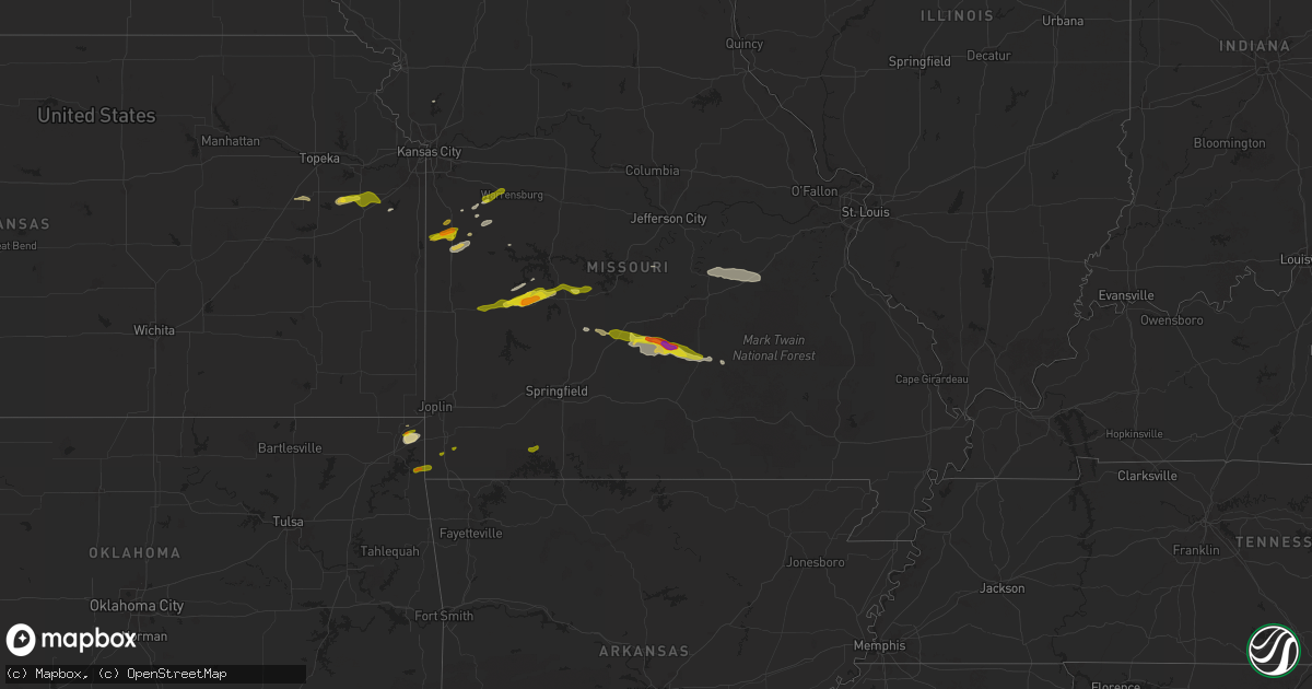
Hail Map on March 22, 2025
Get this storm
March 22 map
$229
one time, instant access
Download today. No call, no setup
Keep the $229
Bought the map and want the full workflow? Apply the entire $229 to a subscription within 7 days. None of it is wasted.
Every map, not just this one
This buys you this map. Subscription and you get every map we run, in the markets you choose from a few cities to whole states to nationwide. Plus real-time alerts the moment a storm fires.
Contact data
Name, contact info, occupancy, even credit band for addresses in the footprint. You go from where it hit to who to call.
Become the source they trust
Unlimited branding weather history reports on demand. You already have the documented answer ready for the property owner, and you are the one who showed up with it.
Property data and RoofTrace estimates
Pull up any address you have got, its value and the exact code rules for that jurisdiction, straight from One Click Code. Then RoofTrace estimates the squares, pitch, and roof value, priced the way you price.
Storm reports
New York
| Date | Description |
|---|---|
| 03/22/20256:57 PM CDT | Mesonet station xbay bayville station elevation: 45 ft. Marine thunderstorm wind gust of 52 kt. |
| 03/21/20257:25 PM CDT | Asos station kisp islip airport. |
Oklahoma
| Date | Description |
|---|---|
| 03/21/202510:09 PM CDT | Report from mping: ping pong ball |
| 03/21/202510:08 PM CDT | A local report indicates 1.00 inch wind near 1 NNW Ottawa |
Kansas
| Date | Description |
|---|---|
| 03/22/20256:31 PM CDT | The asos in goodland |
Missouri
| Date | Description |
|---|---|
| 03/22/20252:15 AM CDT | A local report indicates 1.00 inch wind near Holden |
| 03/22/202512:25 AM CDT | Between versailles and eldon. |
| 03/22/202512:11 AM CDT | Report from social media. |
| 03/22/202512:10 AM CDT | Report via social media. |
| 03/22/202512:03 AM CDT | Southwest of camdenton near lake valley drive. |
| 03/21/202511:55 PM CDT | A local report indicates 1.00 inch wind near Roby |
| 03/21/202511:52 PM CDT | A local report indicates 2.00 inch wind near 3 N Roby |
| 03/21/202511:52 PM CDT | A local report indicates 1.25 inch wind near 3 N Roby |
| 03/21/202511:45 PM CDT | A measured 77 mph wind gust downed multiple four to six inch diameter limbs and took down powerlines. |
| 03/21/202511:41 PM CDT | A local report indicates 1.00 inch wind near Cape Fair |
| 03/21/202511:35 PM CDT | Report from mping ping pong ball size hail. |
| 03/21/202511:32 PM CDT | A local report indicates 1.00 inch wind near Falcon |
| 03/21/202511:32 PM CDT | A local report indicates 1.50 inch wind near Collins |
| 03/21/202511:17 PM CDT | Reports of large trees down near morgan. |
| 03/21/202511:17 PM CDT | Report of a barn destroyed north of morgan. |
| 03/21/202511:07 PM CDT | Numerous pictures and reports of hail in lebanon with maximum size hail at 1 inch in diameter. The hail accumulated several inches deep in lebanon. |
| 03/21/202511:01 PM CDT | Report from mping half dollar size hail. |
| 03/21/202510:42 PM CDT | Time estimated via radar. |
| 03/21/202510:00 PM CDT | Quarter size hail five miles north of south west city on highway 43. |
Cities Impacted by Hail Map on March 22, 2025
- Goodman, MO
- Fairland, OK
- Miami, OK
- Neosho, MO
- Wyandotte, OK
- South West City, MO
- Quapaw, OK
- Buffalo, MO
- Windyville, MO
- Long Lane, MO
- Lebanon, MO
- El Dorado Springs, MO
- Phillipsburg, MO
- Collins, MO
- Butler, MO
- Osceola, MO
- Weaubleau, MO
- Falcon, MO
- Laquey, MO
- Cape Fair, MO
- Lynchburg, MO
- Plato, MO
- Roby, MO
- Licking, MO
- Quincy, MO
- Wheatland, MO
- Amsterdam, MO
- La Cygne, KS
- Clinton, MO
- Success, MO
- Galena, MO
- Adrian, MO
- Hermitage, MO
- Drexel, MO
- Cross Timbers, MO
- Reeds Spring, MO
- Aurora, MO
- Shell Knob, MO
- Urich, MO
- Preston, MO
- Archie, MO
- Tunas, MO
- Macks Creek, MO
- Salem, MO
- Climax Springs, MO
- Burlington, KS
- Ozark, MO
- Spokane, MO
- Bucyrus, MO
- Sparta, MO
- Mountain Grove, MO
- Mansfield, MO
- Seymour, MO
- Highlandville, MO
- Bruner, MO
- Huggins, MO
- Fordland, MO
- Hartville, MO
- Graff, MO
- Garden City, MO
- Freeman, MO
- Harrisonville, MO
- Kingsville, MO
- Plattsburg, MO
- Creighton, MO
- Holden, MO
- Centerview, MO
- Warrensburg, MO
- Walker, MO
- Nevada, MO
- Stockton, MO
- Sheldon, MO
- Jerico Springs, MO
- Harwood, MO
- Burlingame, KS
- Osage City, KS
- Reading, KS
- Harveyville, KS
- Humansville, MO
- Scranton, KS
- Lyndon, KS
- Flemington, MO
- Pomona, KS
- Ottawa, KS
- Overbrook, KS
- Quenemo, KS
- Paola, KS
- Osawatomie, KS
- Baldwin City, KS
- Wellsville, KS
- Vassar, KS
- Louisburg, KS
- Blairstown, MO
- Tuscumbia, MO
- Saint Elizabeth, MO
- Iberia, MO
- Meta, MO
- Saint James, MO
- Vichy, MO
- Cuba, MO
- Bland, MO
- Belle, MO
- Leasburg, MO
- Bourbon, MO
- Owensville, MO
- Grove, OK
- Anderson, MO
- Noel, MO