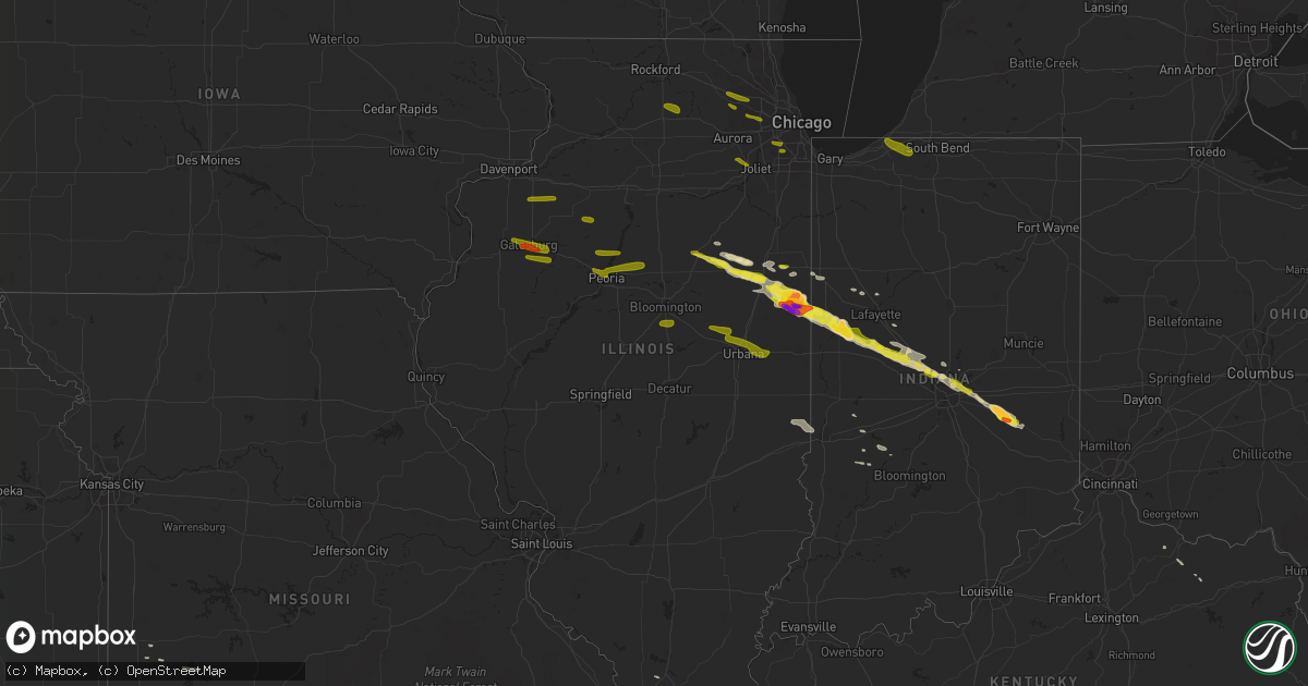
Hail Map in Illinois on March 20, 2017
Get this storm
March 20 map
$229
one time, instant access
Download today. No call, no setup
Keep the $229
Bought the map and want the full workflow? Apply the entire $229 to a subscription within 7 days. None of it is wasted.
Every map, not just this one
This buys you this map. Subscription and you get every map we run, in the markets you choose from a few cities to whole states to nationwide. Plus real-time alerts the moment a storm fires.
Contact data
Name, contact info, occupancy, even credit band for addresses in the footprint. You go from where it hit to who to call.
Become the source they trust
Unlimited branding weather history reports on demand. You already have the documented answer ready for the property owner, and you are the one who showed up with it.
Property data and RoofTrace estimates
Pull up any address you have got, its value and the exact code rules for that jurisdiction, straight from One Click Code. Then RoofTrace estimates the squares, pitch, and roof value, priced the way you price.
Storm reports in Illinois
Illinois
| Date | Description |
|---|---|
| 03/20/201712:30 PM CDT | A local report indicates 2.75 inch wind near HOOPESTON |
| 03/20/201712:16 PM CDT | A local report indicates 2.00 inch wind near HOOPESTON |
| 03/20/201712:06 PM CDT | A local report indicates 1.25 inch wind near PIPER CITY |
| 03/20/201711:43 AM CDT | A local report indicates 1.00 inch wind near CHATSWORTH |
| 03/20/201711:31 AM CDT | Two reports from watseka relayed via twitter. |
| 03/20/201711:28 AM CDT | A local report indicates 1.00 inch wind near 7 WNW WATSEKA |
| 03/20/201711:02 AM CDT | A local report indicates 1.00 inch wind near PONTIAC |
Cities Impacted by Hail Map on March 20, 2017
- Williamsport, IN
- Piper City, IL
- Hoopeston, IL
- Wellington, IL
- Greenfield, IN
- Charlotte, TN
- Rossville, IL
- Cissna Park, IL
- Milford, IL
- Ambia, IN
- Rankin, IL
- Mayfield, KY
- Hickory, KY
- Lebanon, IN
- Sheldon, MO
- El Dorado Springs, MO
- Attica, IN
- Roberts, IL
- Kuttawa, KY
- Wingate, IN
- Rushville, IN
- Arlington, IN
- Morristown, IN
- Shelbyville, IN
- Gwynneville, IN
- Fair Play, MO
- Bolivar, MO
- Aldrich, MO
- Zionsville, IN
- Benton, KY
- Manilla, IN
- Homer, IN
- Carthage, IN
- Milroy, IN
- New Palestine, IN
- Clarks Hill, IN
- Carmel, IN
- Boswell, IN
- Pontiac, IL
- Crawfordsville, IN
- Whitestown, IN
- Chatsworth, IL
- Fountaintown, IN
- Linden, IN
- Colfax, IN
- Buckley, IL
- Thawville, IL
- Onarga, IL
- Thorntown, IN
- New Richmond, IN
- Fairbury, IL
- Indianapolis, IN
- Darlington, IN
- Jamestown, IN
- Westpoint, IN
- Romney, IN
- Forrest, IL
- Saunemin, IL
- Cullom, IL
- Grand Rivers, KY
- Smithland, KY
- Fairview, TN
- West Lafayette, IN
- Brookston, IN
- Fishers, IN
- Westfield, IN
- Murray, KY
- Dickson, TN
- Reelsville, IN
- Brazil, IN
- Dadeville, MO
- Odell, IL
- Clinton, KY
- Earl Park, IN
- Spencer, IN
- Poland, IN
- Lafayette, IN
- Mulberry, IN
- Kingston Springs, TN
- Nevada, MO
- Goreville, IL
- Makanda, IL
- Milo, MO
- Fancy Farm, KY
- Cunningham, KY
- Bardwell, KY
- White Bluff, TN
- Mayslick, KY
- Flemingsburg, KY
- Germantown, KY
- Carbon, IN
- Coal City, IN
- Clay City, IN
- Watseka, IL
- Crescent City, IL
- Paducah, KY
- Boaz, KY
- Kevil, KY
- Melber, KY
- Gosport, IN
- Battle Ground, IN
- Wallingford, KY
- Fowler, IN
- Otterbein, IN
- Danforth, IL
- Dover, TN
- Stockton, MO
- Freedom, IN
- Almo, KY
- Dexter, KY
- Gilman, IL
- Vermilion, IL
- West Terre Haute, IN
- Paris, IL
- Bowling Green, IN
- Michigan City, IN
- La Porte, IN
- Rolling Prairie, IN
- New Carlisle, IN
- Mill Creek, IN
- Cambridge, IL
- Andover, IL
- Lynn Center, IL
- East Galesburg, IL
- Gerlaw, IL
- Alexis, IL
- Monmouth, IL
- Cameron, IL
- Gilson, IL
- Dahinda, IL
- Knoxville, IL
- Galesburg, IL
- Abingdon, IL
- Maquon, IL
- Dundee, IL
- Streamwood, IL
- Hoffman Estates, IL
- Gilberts, IL
- Elgin, IL
- Bartlett, IL
- Glen Ellyn, IL
- Carol Stream, IL
- West Chicago, IL
- Glendale Heights, IL
- Lombard, IL
- South Elgin, IL
- Saint Charles, IL
- Bradford, IL
- Toulon, IL
- Wyoming, IL
- East Peoria, IL
- Washington, IL
- Eureka, IL
- Peoria Heights, IL
- Metamora, IL
- Roanoke, IL
- Peoria, IL
- Edwards, IL
- Hickory Hills, IL
- Willowbrook, IL
- Palos Hills, IL
- Willow Springs, IL
- Dunlap, IL
- Princeville, IL
- Chillicothe, IL
- Edelstein, IL
- Lowpoint, IL
- Shorewood, IL
- Plainfield, IL
- Joliet, IL
- Palos Heights, IL
- Orland Park, IL
- Palos Park, IL
- Rochelle, IL
- Clare, IL
- Kirkland, IL
- Malta, IL
- Esmond, IL
- Heyworth, IL
- Shirley, IL
- Downs, IL
- Champaign, IL
- Dewey, IL
- Fisher, IL
- Bellflower, IL
- Urbana, IL
- Foosland, IL
- Mahomet, IL
- Saint Joseph, IL
- Ogden, IL
- Mccordsville, IN
- Plymouth, WI
- Glenbeulah, WI
- Sheboygan, WI
- Kohler, WI
- Sheboygan Falls, WI


