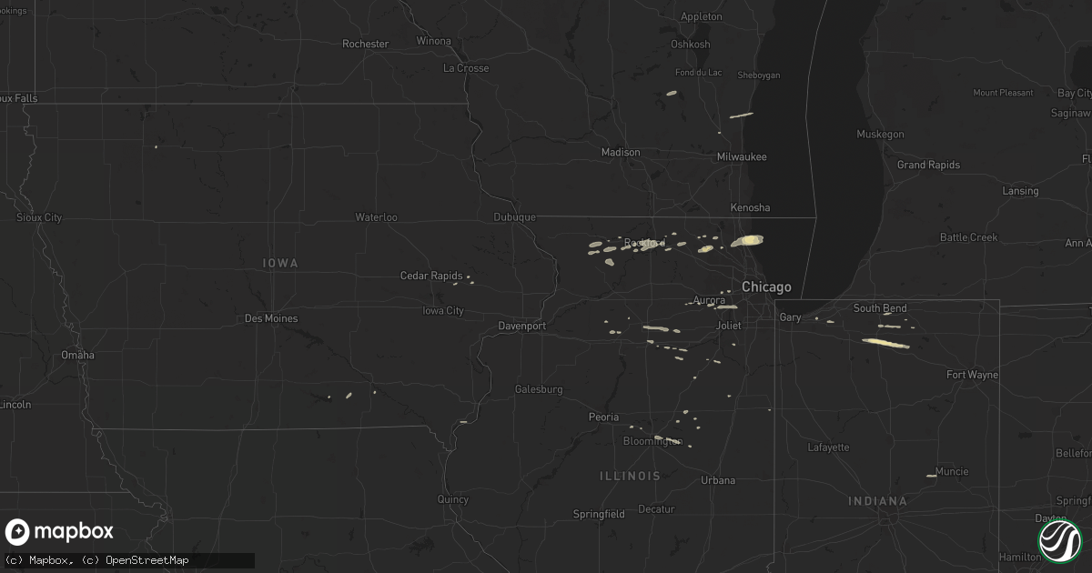
Hail Map in Illinois on March 20, 2011
Get this storm
March 20 map
$229
one time, instant access
Download today. No call, no setup
Keep the $229
Bought the map and want the full workflow? Apply the entire $229 to a subscription within 7 days. None of it is wasted.
Every map, not just this one
This buys you this map. Subscription and you get every map we run, in the markets you choose from a few cities to whole states to nationwide. Plus real-time alerts the moment a storm fires.
Contact data
Name, contact info, occupancy, even credit band for addresses in the footprint. You go from where it hit to who to call.
Become the source they trust
Unlimited branding weather history reports on demand. You already have the documented answer ready for the property owner, and you are the one who showed up with it.
Property data and RoofTrace estimates
Pull up any address you have got, its value and the exact code rules for that jurisdiction, straight from One Click Code. Then RoofTrace estimates the squares, pitch, and roof value, priced the way you price.
Storm reports in Illinois
Illinois
| Date | Description |
|---|---|
| 03/20/20114:09 PM CDT | A local report indicates 1.00 inch wind near CRYSTAL LAKE |
| 03/20/20113:26 PM CDT | Nickel to quarter size hail reported at intersection of rt 47 and reed road. |
| 03/20/20113:25 PM CDT | Observed nickel to quarter size hail off and on for about 5 minutes. |
| 03/20/20112:50 PM CDT | Report from south rockford relayed by wrex-tv. |
| 03/20/20112:05 PM CDT | Nickel to quarter size hail right on the ogle and stephenson county line. |
| 03/19/20117:51 PM CDT | Report from the corner of park blvd and roosevelt road. |
Cities Impacted by Hail Map on March 20, 2011
- Aurora, IL
- Oswego, IL
- Montgomery, IL
- West Bend, WI
- Port Washington, WI
- Saukville, WI
- Nappanee, IN
- Bremen, IN
- Wakarusa, IN
- Rockford, IL
- Winnebago, IL
- Baileyville, IL
- Shannon, IL
- Cherry Valley, IL
- Plymouth, IN
- Bourbon, IN
- Lakeville, IN
- North Chicago, IL
- Great Lakes, IL
- Lake Bluff, IL
- Lake Forest, IL
- Lisbon, IA
- Plainfield, IL
- Naperville, IL
- Pecatonica, IL
- Leaf River, IL
- Gardner, IL
- Fort Madison, IA
- Ransom, IL
- Grand Ridge, IL
- Ohio, IL
- Princeton, IL
- Woodstock, IL
- German Valley, IL
- Freeport, IL
- Bloomington, IL
- Normal, IL
- Danvers, IL
- Goodfield, IL
- Congerville, IL
- Mchenry, IL
- Mechanicsville, IA
- Ellsworth, IL
- Arrowsmith, IL
- Cooksville, IL
- Marengo, IL
- Plano, IL
- Big Rock, IL
- Ashkum, IL
- Essex, IL
- Braceville, IL
- Barrington, IL
- Blakesburg, IA
- Unionville, IA
- Stanwood, IA
- Westville, IN
- La Porte, IN
- Crystal Lake, IL
- Lake In The Hills, IL
- Marseilles, IL
- Ottawa, IL
- Dickens, IA
- Woodridge, IL
- Lemont, IL
- Bolingbrook, IL
- Etna Green, IN
- Walnut, IL
- Mendota, IL
- Earlville, IL
- Triumph, IL
- Sheridan, IL
- Fairbury, IL
- Mishawaka, IN
- South Bend, IN
- Goshen, IN
- Fox Lake, WI
- Waupun, WI
- Germantown, WI
- Hubertus, WI
- Saybrook, IL
- Belvidere, IL
- Cary, IL
- Huntley, IL
- Bristol, IL
- Sugar Grove, IL
- La Moille, IL
- Libertyville, IL
- Byron, IL
- Seneca, IL
- Chenoa, IL
- Garden Prairie, IL
- Capron, IL
- Leesburg, IN
- Ridott, IL
- Warrenville, IL
- Sheldon, IL
- Moravia, IA
- Carlock, IL
- Poplar Grove, IL
- Odell, IL
- Anderson, IN
- Daleville, IN
- Mundelein, IL
- Lake Zurich, IL
- Vernon Hills, IL
- New Paris, IN
- Mount Morris, IL
- Forreston, IL
- Serena, IL
- Sibley, IL
- Lexington, IL
- Pearl City, IL
- Warsaw, IN
- Utica, IL
- La Salle, IL
- Glen Ellyn, IL
- Wheaton, IL
- Walkerton, IN
- Chesterton, IN
- Bloomfield, IA
- Ottumwa, IA
- Manhattan, IL


