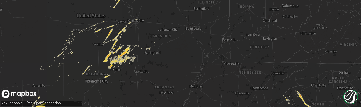
Hail Map on March 19, 2011
The weather event on March 19, 2011 includes Hail map. 9 states and 474 cities were impacted and suffered possible damage. The total estimated number of properties impacted is 0.
Want more than just the map?
Turn this storm into a full workflow.
- Owner + property data so you know who to knock
- OnDemand branded weather history reports to win the "did we even have hail?" argument
- RoofTrace estimate so reps stop guessing numbers at the door
Bought this map? Upgrade within 7 days and we'll credit the $230. (10-15 min setup call)
Hail
0
Estimated number of impacted properties by a 1.00" hail or larger0
Estimated number of impacted properties by a 1.75" hail or larger0
Estimated number of impacted properties by a 2.50" hail or largerStates Impacted by Hail Map on March 19, 2011
Storm reports
South Dakota
| Date | Description |
|---|---|
| 03/19/20112:09 AM CDT | Quarter size hail with light accumulation. Winds strong but not damaging. |
Missouri
| Date | Description |
|---|---|
| 03/19/20112:00 PM CDT | A local report indicates 1.00 inch wind near 3 E JOPLIN |
| 03/19/20111:04 PM CDT | A local report indicates 1.00 inch wind near 3 SE LIBERTY |
| 03/19/20113:05 AM CDT | Time estimated |
Kansas
| Date | Description |
|---|---|
| 03/19/20111:22 PM CDT | A local report indicates 1.00 inch wind near 1 ESE MINNEOLA |
| 03/19/201111:54 AM CDT | A local report indicates 1.00 inch wind near 6 N COUNCIL GROVE |
| 03/19/201111:22 AM CDT | Public reported quarter sized hail covering the ground. |
| 03/19/201111:03 AM CDT | A local report indicates 1.00 inch wind near 4 SSW QUENEMO |
| 03/19/201110:47 AM CDT | Accidents reported along i-35. |
| 03/19/201110:44 AM CDT | A local report indicates 1.75 inch wind near 3 SE PARSONS |
| 03/19/201110:38 AM CDT | A local report indicates 1.75 inch wind near COTTONWOOD FALLS |
| 03/19/201110:37 AM CDT | A local report indicates 1.50 inch wind near N COTTONWOOD FALLS |
| 03/19/201110:36 AM CDT | A local report indicates 1.00 inch wind near 3 S COTTONWOOD FALLS |
| 03/19/201110:17 AM CDT | A local report indicates 1.00 inch wind near 5 N ALTAMONT |
| 03/19/201110:10 AM CDT | A local report indicates 1.25 inch wind near 2 W ALTAMONT |
| 03/19/201110:09 AM CDT | A local report indicates 1.00 inch wind near ALTAMONT |
| 03/19/201110:03 AM CDT | A local report indicates 1.00 inch wind near 2 W ALTAMONT |
| 03/19/201110:01 AM CDT | Family member of nws employee reports golfball sized relayed by nws springfield. |
| 03/19/20118:51 AM CDT | A local report indicates 2.00 inch wind near 3 E COFFEYVILLE |
| 03/19/20118:38 AM CDT | A local report indicates 1.00 inch wind near COFFEYVILLE |
| 03/19/20118:18 AM CDT | Emergency manager reports penny to quarter sized hail. |
| 03/18/20117:37 PM CDT | Delayed report |
| 03/18/20117:15 PM CDT | A local report indicates 1.00 inch wind near SALINA |
Nebraska
| Date | Description |
|---|---|
| 03/19/20112:48 AM CDT | A local report indicates 1.00 inch wind near 5 SE AUBURN |
| 03/19/20112:45 AM CDT | A local report indicates 1.00 inch wind near 7 N SPENCER |
| 03/19/20111:15 AM CDT | A local report indicates 1.00 inch wind near 10 SE SPRINGVIEW |
South Carolina
| Date | Description |
|---|---|
| 03/19/20116:20 PM CDT | Hail fell for 20 to 25 minutes. Ranged from 0.75 to 1.00 inch in size. Heavy rain and gusty wind also observed 2 miles west of the town of saluda on highway 178. |
| 03/19/20115:51 PM CDT | Newberry county sheriff reported tree on car and powerlines down. |
| 03/19/20115:50 PM CDT | Saluda county sheriff reported numerous trees down across the county. |
| 03/19/20115:09 PM CDT | Numerous trees reported down from waterloo to cross hill |
| 03/19/20115:05 PM CDT | Public report of hail up to half dollar sized lasting for at least several minutes in cross hill. Based on radar the hail likely lasted to as late as 625 pm. |
| 03/19/20114:50 PM CDT | Trees down in the road in the vicinity of waterloo. Several vehicular accidents. |
| 03/19/20114:47 PM CDT | Two cedar trees just uprooted. As i asked for more information we were cut off. |
| 03/19/20114:15 PM CDT | A local report indicates 1.00 inch wind near GRAY COURT |
| 03/19/20114:12 PM CDT | Hail up to the size of golf balls covering the ground. Had wind measuring equipment which recorded a 57 mph gust. No report of wind damage as of yet. |
| 03/19/20113:15 PM CDT | Large branches broken |
| 03/19/20113:07 PM CDT | Gantt fire department station 2 experienced hail covering the ground with hail as large as a quarter which lasted at least 5 minutes. Had strong wind gusts as well but |
| 03/18/20117:15 PM CDT | Panel on equipment building ripped off. Several large limbs down on property. |
| 03/18/20117:15 PM CDT | Panel on equipment building ripped off. Several large limbs down on property. |
North Carolina
| Date | Description |
|---|---|
| 03/19/20115:50 PM CDT | Saluda county sheriff reported numerous trees down across the county. |
Iowa
| Date | Description |
|---|---|
| 03/19/20113:41 AM CDT | Hailed for 2 minutes and covered the ground. |
| 03/19/20113:30 AM CDT | A local report indicates 1.00 inch wind near SHENANDOAH |
Georgia
| Date | Description |
|---|---|
| 03/18/20117:58 PM CDT | Tin roof blown off a church on shirley road and some 2x4s stripped off the same building. Three trees down in the shirley...doug drake road area...including one pine tr |
| 03/18/20117:29 PM CDT | Got hail up to quarter sized that lasted a few minutes. No reports of wind damage in franklin county. |
Oklahoma
| Date | Description |
|---|---|
| 03/19/20112:40 PM CDT | A local report indicates 1.00 inch wind near 1 WSW ENID |
| 03/19/20111:27 PM CDT | Relayed by wfo sgf |
| 03/19/201111:36 AM CDT | A local report indicates 1.00 inch wind near BARTLESVILLE |
| 03/19/20119:50 AM CDT | Public report relayed by media |
| 03/19/20119:45 AM CDT | A local report indicates 1.00 inch wind near OSAGE |
Texas
| Date | Description |
|---|---|
| 03/19/20116:07 PM CDT | A local report indicates 1.75 inch wind near 6 SE ANTON |
| 03/18/201110:47 PM CDT | One inch hail reported on the road along 54 near county road z. |
| 03/18/201110:27 PM CDT | One inch hail on the ground. |
| 03/18/201110:13 PM CDT | One half to 1 inch hail on ground in downtown abernathy. |
| 03/18/20119:18 PM CDT | A local report indicates 1.00 inch wind near 6 NE LUBBOCK |
| 03/18/20118:58 PM CDT | A local report indicates 2.75 inch wind near 1 E SHALLOWATER |
| 03/18/20118:55 PM CDT | A local report indicates 1.75 inch wind near SHALLOWATER |
| 03/18/20118:54 PM CDT | A local report indicates 1.50 inch wind near SHALLOWATER |
| 03/18/20118:40 PM CDT | A local report indicates 1.00 inch wind near PLAINVIEW |
| 03/18/20118:35 PM CDT | A local report indicates 1.00 inch wind near PLAINVIEW |
| 03/18/20118:28 PM CDT | A local report indicates 1.75 inch wind near 2 NE SMYER |
| 03/18/20118:25 PM CDT | A local report indicates 1.00 inch wind near 1 S PLAINVIEW |
| 03/18/20117:57 PM CDT | A local report indicates 1.00 inch wind near 4 S LOCKNEY |
| 03/18/20117:46 PM CDT | A local report indicates 1.00 inch wind near LEVELLAND |
| 03/18/20117:45 PM CDT | A local report indicates 1.75 inch wind near LEVELLAND |
Cities Impacted by Hail Map on March 19, 2011
- Delaware, OK
- Ramona, OK
- Talala, OK
- Dewey, OK
- Edna, KS
- Lenapah, OK
- Hominy, OK
- Caney, KS
- Altamont, KS
- Copan, OK
- Chelsea, OK
- Bartlesville, OK
- Mound Valley, KS
- McCune, KS
- Pawhuska, OK
- Wann, OK
- Vinita, OK
- Nowata, OK
- Cleveland, OK
- Parsons, KS
- S Coffeyville, OK
- Wynona, OK
- Coffeyville, KS
- Walnut, KS
- Osage, OK
- Girard, KS
- Barnsdall, OK
- Saint Paul, KS
- Ochelata, OK
- Oswego, KS
- Tyro, KS
- Liberty, KS
- Galesburg, KS
- Minneola, KS
- Lubbock, TX
- Whiteface, TX
- Shallowater, TX
- Idalou, TX
- Levelland, TX
- Neodesha, KS
- Altoona, KS
- Fredonia, KS
- Elk City, KS
- Afton, OK
- Thayer, KS
- Strong City, KS
- Cottonwood Falls, KS
- Olton, TX
- Augusta, KS
- Olathe, KS
- Lawrence, KS
- Linwood, KS
- Shawnee, KS
- Lenexa, KS
- De Soto, KS
- Bonner Springs, KS
- Baldwin City, KS
- Eudora, KS
- Sand Springs, OK
- Anton, TX
- Honea Path, SC
- Belton, SC
- Decatur, IA
- Davis City, IA
- Lamoni, IA
- Kellerton, IA
- Leon, IA
- Ash Grove, MO
- Spearville, KS
- Ninety Six, SC
- Chappells, SC
- Saluda, SC
- Glidden, IA
- Lohrville, IA
- Churdan, IA
- Lake City, IA
- Carroll, IA
- Carnesville, GA
- Toccoa, GA
- Hudson, IA
- Cedar Falls, IA
- Audubon, IA
- Chapman, KS
- Abilene, KS
- Howard, KS
- Gypsum, KS
- Roxbury, KS
- Mcpherson, KS
- Galva, KS
- Hope, KS
- Durham, KS
- Tampa, KS
- Canton, KS
- Alden, IA
- Kamrar, IA
- Blairsburg, IA
- Williams, IA
- Jewell, IA
- Gray Court, SC
- Laurens, SC
- Fountain Inn, SC
- Baxter, IA
- Melbourne, IA
- Conrad, IA
- State Center, IA
- Rhodes, IA
- Beaman, IA
- Maxwell, IA
- Marshalltown, IA
- Mingo, IA
- Albion, IA
- Bondurant, IA
- Collins, IA
- Meno, OK
- Enid, OK
- Lahoma, OK
- Drummond, OK
- Auburn, NE
- Johnson, NE
- Greenville, SC
- Shidler, OK
- Kansas City, MO
- Watson, MO
- Farragut, IA
- Brownville, NE
- Riverton, IA
- Hamburg, IA
- Rock Port, MO
- Peru, NE
- Brock, NE
- Stella, NE
- Humboldt, NE
- Nemaha, NE
- Farnhamville, IA
- Lanesboro, IA
- Rockwell City, IA
- Stroud, OK
- Depew, OK
- Davenport, OK
- Chandler, OK
- Westminster, SC
- Pomona, KS
- Pawnee Rock, KS
- Beaver, OK
- Balko, OK
- Hale Center, TX
- Royston, GA
- Cross Hill, SC
- Waterloo, SC
- Mountville, SC
- Leesville, SC
- Batesburg, SC
- Pelzer, SC
- Piedmont, SC
- Easley, SC
- Gilbert, SC
- Mauldin, SC
- Ware Shoals, SC
- Ward, SC
- Ridge Spring, SC
- Simpsonville, SC
- Monetta, SC
- Alta Vista, KS
- Alma, KS
- Council Grove, KS
- Eskridge, KS
- Wilsey, KS
- Plainview, TX
- Lockney, TX
- Arcadia, KS
- Fairland, OK
- Miami, OK
- Pawnee, OK
- Herington, KS
- Bluejacket, OK
- Welch, OK
- Virgil, KS
- Hamilton, KS
- Madison, KS
- Gridley, KS
- Hanston, KS
- Essex, IA
- Red Oak, IA
- Malvern, IA
- Floydada, TX
- Littlefield, TX
- Lyons, KS
- Dexter, KS
- Burbank, OK
- Ponca City, OK
- Fairfax, OK
- Cedar Vale, KS
- Kaw City, OK
- Blockton, IA
- Benton, IA
- Weldon, IA
- Garden Grove, IA
- Wagner, SD
- Tripp, SD
- Inman, KS
- Moline, KS
- Princeton, KS
- Lebo, KS
- Neal, KS
- Severy, KS
- Williamsburg, KS
- Toronto, KS
- Ottawa, KS
- Yates Center, KS
- Melvern, KS
- Fall River, KS
- Waverly, KS
- Eureka, KS
- Grenola, KS
- Richmond, KS
- Burlington, KS
- Hartford, KS
- Quenemo, KS
- Osage City, KS
- Guthrie Center, IA
- Rush Center, KS
- Burdett, KS
- Le Roy, KS
- Hammon, OK
- Cheyenne, OK
- Leedey, OK
- Buffalo, MO
- Stanhope, IA
- Ellsworth, IA
- Stratford, IA
- Boone, IA
- Lorenzo, TX
- New Deal, TX
- Abernathy, TX
- Petersburg, TX
- Smyer, TX
- Columbus, KS
- Chetopa, KS
- Claremore, OK
- Oologah, OK
- Picher, OK
- Commerce, OK
- Bartlett, KS
- Independence, KS
- North Miami, OK
- Jennings, OK
- Dennis, KS
- Terlton, OK
- Cherryvale, KS
- Waynoka, OK
- Kimballton, IA
- Harlan, IA
- Kinsley, KS
- Reinbeck, IA
- Grundy Center, IA
- Lincoln, IA
- Gladbrook, IA
- Watonga, OK
- Canton, OK
- Longton, KS
- Elk Falls, KS
- Walnut Grove, MO
- Meade, KS
- Larned, KS
- Tulsa, OK
- Hubbard, IA
- McCallsburg, IA
- Zearing, IA
- Dante, SD
- Dawson, IA
- Yale, IA
- Panora, IA
- Linden, IA
- Ogden, IA
- Perry, IA
- Seneca, KS
- Dawson, NE
- Westboro, MO
- Du Bois, NE
- Shenandoah, IA
- Bern, KS
- Ellinwood, KS
- El Dorado, KS
- Westphalia, KS
- Salina, KS
- Naper, NE
- Eldora, IA
- Spencer, NE
- Bristow, NE
- Fairfax, SD
- Burns, KS
- Bucklin, KS
- Ames, OK
- Isabella, OK
- Okeene, OK
- Mullinville, KS
- Crescent, OK
- Casey, IA
- Bayard, IA
- Tulia, TX
- Kress, TX
- Sedan, KS
- Emporia, KS
- Cedar Point, KS
- Coldwater, KS
- Baileyville, KS
- Anita, IA
- Amherst, TX
- Fieldton, TX
- Prue, OK
- Leon, KS
- Glenwood, IA
- Tabor, IA
- Corydon, IA
- Chariton, IA
- Traer, IA
- Toledo, IA
- Butte, NE
- Otho, IA
- Americus, KS
- Matfield Green, KS
- Humeston, IA
- Henderson, IA
- Hastings, IA
- Independence, MO
- Liberty, MO
- Duncombe, IA
- Fort Dodge, IA
- Callender, IA
- Gowrie, IA
- Tingley, IA
- Shannon City, IA
- Ellsworth, KS
- Lorraine, KS
- Waukomis, OK
- Hennessey, OK
- Niotaze, KS
- Peru, KS
- Junction City, KS
- Hardesty, OK
- Ankeny, IA
- Altoona, IA
- Forgan, OK
- Offerle, KS
- Ashland, KS
- Webster City, IA
- Diagonal, IA
- Peterson, IA
- Stanberry, MO
- Worth, MO
- Sheridan, MO
- Ravenwood, MO
- Grant City, MO
- Clyde, MO
- Jefferson, IA
- Scranton, IA
- Cassoday, KS
- Waterloo, IA
- Washington, GA
- Tignall, GA
- Elk Horn, IA
- Templeton, IA
- Dedham, IA
- Vermillion, KS
- Moundridge, KS
- Perryton, TX
- Booker, TX
- Comer, GA
- Dewy Rose, GA
- Elberton, GA
- Bowman, GA
- Carlton, GA
- Grove, OK
- Wyandotte, OK
- Ruthven, IA
- Everton, MO
- Lavonia, GA
- Canon, GA
- Mooreland, OK
- Liberal, MO
- Mulberry, KS
- Mindenmines, MO
- Maple City, KS
- Morrisville, MO
- Urbana, MO
- Louisburg, MO
- Garber, OK
- Eastanollee, GA
- Rosston, OK
- Englewood, KS
- Seneca, MO
- Mills, NE
- West Mineral, KS
- Scammon, KS
- Weir, KS
- Pittsburg, KS
- Cherokee, KS
- Axtell, KS
- Quapaw, OK
- Fair Play, SC
- Eagle Grove, IA
- Benedict, KS
- Protection, KS
- Follett, TX
- Lehigh, IA
- Lexington, SC
- Pelion, SC
- Buffalo, KS
- Promise City, IA
- Plano, IA
- Mobeetie, TX
- Aldrich, MO
- Bolivar, MO
- Otis, KS
- Dadeville, MO
- Gruver, TX
- Sunray, TX
- Conception, MO
- Conception Junction, MO
- Bedford, IA
- Wright, KS
- Gaston, SC
- Swansea, SC
- Lamar, MO
- Golden City, MO
- Des Moines, IA
- Garwin, IA
- Haverhill, IA
- Berwick, IA
- Fort Riley, KS
- Riverton, KS
- Galena, KS
- New Providence, IA
- Rozel, KS
- La Porte City, IA
- Buckingham, IA
- Dysart, IA
- Clarinda, IA
- Great Bend, KS
- Mount Airy, GA
- Laverne, OK
- Geneseo, KS
- Bolckow, MO
- Solomon, KS
- New Cambria, KS
- Table Rock, NE
- Elk Creek, NE
- Chanute, KS
- Bristow, OK
- Russell, IA
- Half Way, MO
- Collinsville, OK
- Brookville, KS
- Manning, IA
- Gray, IA
- Walnut, IA
- Martin, GA
- Claflin, KS
- Holyrood, KS
- Wiota, IA
- Centerville, IA
- Mystic, IA
- Beattie, KS
- Hepler, KS
- Farlington, KS
- Ford, KS
- Greenfield, MO
- Hitchcock, OK
- Belpre, KS
- Lewis, KS
- Shattuck, OK
- Spencer, IA
- Assaria, KS
- Lindsborg, KS