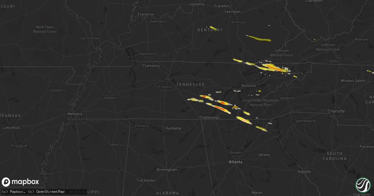
Hail Map in Tennessee on March 17, 2018
Get this storm
March 17 map
$229
one time, instant access
Download today. No call, no setup
Keep the $229
Bought the map and want the full workflow? Apply the entire $229 to a subscription within 7 days. None of it is wasted.
Every map, not just this one
This buys you this map. Subscription and you get every map we run, in the markets you choose from a few cities to whole states to nationwide. Plus real-time alerts the moment a storm fires.
Contact data
Name, contact info, occupancy, even credit band for addresses in the footprint. You go from where it hit to who to call.
Become the source they trust
Unlimited branding weather history reports on demand. You already have the documented answer ready for the property owner, and you are the one who showed up with it.
Property data and RoofTrace estimates
Pull up any address you have got, its value and the exact code rules for that jurisdiction, straight from One Click Code. Then RoofTrace estimates the squares, pitch, and roof value, priced the way you price.
Storm reports in Tennessee
Tennessee
| Date | Description |
|---|---|
| 03/17/20186:57 PM CDT | Also reported 0.50 inch sized hail. |
| 03/17/20186:48 PM CDT | A local report indicates 1.75 inch wind near 2 N TASSO |
| 03/17/20186:45 PM CDT | A local report indicates 1.00 inch wind near SNEEDVILLE |
| 03/17/20186:35 PM CDT | Reported at 787 riley lane birchwood tn. |
| 03/17/20186:35 PM CDT | A local report indicates 1.50 inch wind near 3 N MOUNT VERNON |
| 03/17/20186:30 PM CDT | A local report indicates 1.00 inch wind near ATHENS |
| 03/17/20186:30 PM CDT | Reported at 170 mill dam road. Also reported 50 mph winds. |
| 03/17/20186:15 PM CDT | Quarter size hail near lenior city. |
| 03/17/20186:05 PM CDT | Reported by public. Hail occurred for 10 minutes. |
| 03/17/20185:55 PM CDT | Quarter to half dollar size hail northwest of dunlap... Tn. |
| 03/17/20185:25 PM CDT | Quarter to half dollar size hail just south of pikeville... Tn. |
| 03/17/20185:07 PM CDT | Fall creek falls golf course covered with quarters and nickels. |
| 03/17/20185:23 AM CDT | At 1023 PM EDT, a severe thunderstorm was located 10 miles southeast of Maryville, moving east at 40 mph. HAZARD...60 mph wind gusts and quarter size hail. SOURCE...Radar indicated. IMPACT...Hail damage to vehicles is expected. Expect wind damage to roofs, siding, and trees. Locations impacted include... Gatlinburg, Smoky Mountains-Clingmans Dome, Smoky Mountains-Newfound Gap, Smoky Mountains-Fontana Area, Smoky Mountains-Balsam Mountain, Pittman Center, Townsend, Walland, Wears Valley, Cades Cove, Elkmont, Great Smoky Mountains National Park and Roundtop Mountain State Park. |
| 03/17/20184:11 AM CDT | At 911 PM EDT, a severe thunderstorm was located near Rogersville, moving east at 50 mph. HAZARD...60 mph wind gusts and quarter size hail. SOURCE...Radar indicated. IMPACT...Hail damage to vehicles is expected. Expect wind damage to roofs, siding, and trees. Locations impacted include... Johnson City, Kingsport, Bristol Tn, Rogersville, Jonesborough, Surgoinsville, Spurgeon, Midway, Colonial Heights, Gray, Oak Grove, Church Hill, Mount Carmel, Baileyton, Leesburg, Bays Mountain State Park, Sullivan Gardens, Avondale, Kepler and Jearoldstown. |
| 03/17/20183:37 AM CDT | At 837 PM EDT, a severe thunderstorm was located over Rogersville, moving east at 40 mph. HAZARD...60 mph wind gusts and quarter size hail. SOURCE...Radar indicated. IMPACT...Hail damage to vehicles is expected. Expect wind damage to roofs, siding, and trees. Locations impacted include... Johnson City, Greeneville, Rogersville, Jonesborough, Tusculum, Gray, Midway, Baileyton, Leesburg, Chucky, Limestone, Romeo, McCloud, Telford, Fall Branch, Avondale, St. Clair, Kepler, Davy Crockett Birthplace and Jearoldstown. |
| 03/17/20183:11 AM CDT | At 811 PM EDT, a severe thunderstorm was located near Spring City, or 11 miles southwest of Rockwood, moving east at 55 mph. HAZARD...60 mph wind gusts and quarter size hail. SOURCE...Radar indicated. IMPACT...Hail damage to vehicles is expected. Expect wind damage to roofs, siding, and trees. Locations impacted include... Oak Ridge, Lenoir City, Kingston, Rockwood, Loudon, Fairview, Spring City, Midtown, Harriman, Greenback, Friendsville, Philadelphia, Paint Rock, Bradbury, Eagle Furnace, Stinging Fork Falls State Park, Piney Falls State Park, Tellico Village and Grandview. |
| 03/17/20183:10 AM CDT | At 809 PM EDT, a severe thunderstorm was located over Archville, or 8 miles east of Benton, moving southeast at 50 mph. HAZARD...60 mph wind gusts and quarter size hail. SOURCE...Radar indicated. IMPACT...Hail damage to vehicles is expected. Expect wind damage to roofs, siding, and trees. Locations impacted include... Blairsville, Young Harris, Morganton, Hemp, Gumlog, Nottely Dam, Ivy Log, Loving, Jones Creek, Woods Hole Shelter, Owltown, Mineral Bluff, Vogel State Park, Track Rock, Blood Mountain Shelter, Alexanders Mill, Culberson and Copperhill. |
| 03/17/20183:02 AM CDT | At 802 PM EDT, a severe thunderstorm was located near Surgoinsville, or near Rogersville, moving east at 40 mph. HAZARD...60 mph wind gusts and half dollar size hail. SOURCE...Radar indicated. IMPACT...Hail damage to vehicles is expected. Expect wind damage to roofs, siding, and trees. Locations impacted include... Johnson City, Kingsport, Rogersville, Jonesborough, Surgoinsville, Spurgeon, Midway, Colonial Heights, Gray, Oak Grove, Church Hill, Bluff City, Watauga, Baileyton, Leesburg, Chucky, Limestone, McCloud, Sullivan Gardens and Avondale. |
| 03/17/20182:56 AM CDT | At 756 PM EDT, a severe thunderstorm was located near Tazewell, or 10 miles north of Rutledge, moving east at 45 mph. HAZARD...60 mph wind gusts and quarter size hail. SOURCE...Radar indicated. IMPACT...Hail damage to vehicles is expected. Expect wind damage to roofs, siding, and trees. Locations impacted include... Rogersville, New Tazewell, Bean Station, Tazewell, Russellville, Bulls Gap, Howard Quarter, Thorn Hill, Treadway, McCloud, Mooresburg, St. Clair and Klondike. |
| 03/17/20182:42 AM CDT | At 742 PM EDT, a severe thunderstorm was located over Alcoa, moving east at 35 mph. HAZARD...60 mph wind gusts and quarter size hail. SOURCE...Radar indicated. IMPACT...Hail damage to vehicles is expected. Expect wind damage to roofs, siding, and trees. Locations impacted include... Knoxville, Maryville, Sevierville, Alcoa, Gatlinburg, Pigeon Forge, Louisville, Rockford, Eagleton Village, Pittman Center, Wildwood, McMahan, Wears Valley, Harrisburg, Seymour, Walland, Fairgarden and Great Smoky Mountains National Park. |
| 03/17/20182:21 AM CDT | At 721 PM EDT, a severe thunderstorm was located 7 miles northeast of Soddy-Daisy, or 11 miles south of Dayton, moving east at 35 mph. HAZARD...Ping pong ball size hail and 60 mph wind gusts. SOURCE...Radar indicated. IMPACT...People and animals outdoors will be injured. Expect hail damage to roofs, siding, windows, and vehicles. Expect wind damage to roofs, siding, and trees. Locations impacted include... Cleveland, Benton, Soddy-Daisy, Etowah, Charleston, East Cleveland, Calhoun, Flat Top Mountain, Parksville, Hopewell, Reliance, Hiwassee Ocoee State Park, Big Spring, Tasso, Sale Creek, Birchwood and Dentville. |
| 03/17/20181:39 AM CDT | At 638 PM EDT/538 PM CDT/, a severe thunderstorm was located 9 miles northeast of Gruetli-Laager, or 13 miles northwest of Dunlap, moving east at 40 mph. HAZARD...60 mph wind gusts and half dollar size hail. SOURCE...Radar indicated. IMPACT...Hail damage to vehicles is expected. Expect wind damage to roofs, siding, and trees. Locations impacted include... Dayton, Dunlap, Soddy-Daisy, Graysville, Flat Top Mountain, Sale Creek, Palio, Brayton, Birchwood, Shady Grove, Cagle, Old Cumberland and Mowbray Mountain. |
| 03/17/20181:38 AM CDT | At 637 PM EDT, a severe thunderstorm was located over Dayton, moving east at 40 mph. HAZARD...60 mph wind gusts and quarter size hail. SOURCE...Radar indicated. IMPACT...Hail damage to vehicles is expected. Expect wind damage to roofs, siding, and trees. Locations impacted include... Athens, Dayton, Decatur, Etowah, Englewood, Graysville, Niota, Calhoun, Riceville, Hillsview, Clear Water, Big Spring, Evensville, Old Washington and Dentville. |
| 03/17/20181:04 AM CDT | At 603 PM EDT/503 PM CDT/, a severe thunderstorm was located 9 miles south of Spencer, moving east at 40 mph. HAZARD...60 mph wind gusts and quarter size hail. SOURCE...Radar indicated. IMPACT...Hail damage to vehicles is expected. Expect wind damage to roofs, siding, and trees. Locations impacted include... Dayton, Pikeville, Decatur, Spring City, Graysville, Peakland, Mount Crest, Big Spring, Evensville, Fall Creek Falls State Park, Old Washington, Brayton and Old Cumberland. |
| 03/17/201812:01 AM CDT | At 500 PM CDT, a severe thunderstorm was located near Spencer, moving east at 55 mph. HAZARD...60 mph wind gusts and quarter size hail. SOURCE...Radar indicated. IMPACT...Hail damage to vehicles is expected. Expect wind damage to roofs, siding, and trees. Locations impacted include... Spencer and Fall Creek Falls State Park. |
| 03/16/20189:10 PM CDT | Trees down near gray... Tn. |
| 03/16/20189:00 PM CDT | A few trees down between russellville and whitesburg... Tn. |
| 03/16/20188:35 PM CDT | Several trees and power lines down between church hill and surgoinsville... Tn. |
| 03/16/20188:30 PM CDT | A local report indicates 1.00 inch wind near 2 E PIGEON FORGE |
| 03/16/20188:15 PM CDT | Reported at king springs road tn and dave buck road. Also reported 0.50 inch hail. |
| 03/16/20188:05 PM CDT | Half dollar size hail and few trees down near baileyton... Tn. |
| 03/16/20188:03 PM CDT | A local report indicates 1.00 inch wind near LIMESTONE COVE |
| 03/16/20187:25 PM CDT | Half dollar size hail near mooresburg... Tn. |
| 03/16/20187:24 PM CDT | Reported at i-26 welcome center. |
| 03/16/20187:20 PM CDT | Several reports of golfball size hail across polk county... Tn. |
| 03/16/20187:01 PM CDT | Also reported estimated 50 mph winds. Reported at 119 devils nose road tn. |
| 03/16/20187:00 PM CDT | Quarter inch size hail near alcoa... Tn. |
| 03/16/20187:00 PM CDT | A local report indicates 1.00 inch wind near 6 SSE KYLES FORD |
All States Impacted by Hail Map on March 17, 2018
Cities Impacted by Hail Map on March 17, 2018
- Ballinger, TX
- Norton, TX
- Franklin, TX
- Charleston, TN
- Cleveland, TN
- Brownwood, TX
- Santa Anna, TX
- Florence, TX
- Rock Island, TN
- Spencer, TN
- Pikeville, TN
- Gatesville, TX
- Floresville, TX
- Briggs, TX
- Lampasas, TX
- Kempner, TX
- Tazewell, TN
- Harrogate, TN
- Ewing, VA
- Franklinton, NC
- Louisburg, NC
- Jarrell, TX
- Dunlap, TN
- Reidsville, NC
- Decatur, TN
- Dayton, TN
- Athens, TN
- Riceville, TN
- Greeneville, TN
- Chuckey, TN
- Speedwell, TN
- Mooresburg, TN
- Cumberland Gap, TN
- Surgoinsville, TN
- Fall Branch, TN
- Limestone, TN
- Rogersville, TN
- Church Hill, TN
- Whitesburg, TN
- Sneedville, TN
- Eidson, TN
- Thorn Hill, TN
- Moody, TX
- Bruceville, TX
- Eddy, TX
- McGregor, TX
- Oglesby, TX
- Chilton, TX
- Lorena, TX
- Morrison, TN
- Bremond, TX
- Kosse, TX
- Bartlett, TX
- Georgetown, TX
- San Saba, TX
- Morganton, GA
- Mineral Bluff, GA
- Benton, TN
- Normangee, TX
- Georgetown, TN
- Williamsburg, KY
- Pine Knot, KY
- Crockett, TX
- Centerville, TX
- Lovelady, TX
- Leona, TX
- Madisonville, TX
- Midway, TX
- Marquez, TX
- May, TX
- Murphy, NC
- Blairsville, GA
- Young Harris, GA
- Pound, VA
- Marble, NC
- Mcminnville, TN
- Coleman, TX
- Columbia, MS
- Lumberton, MS
- Clarkesville, GA
- Copperas Cove, TX
- Manchester, TN
- Mountain Rest, SC
- Foxworth, MS
- Loretto, KY
- Saint Francis, KY
- Tellico Plains, TN
- Englewood, TN
- Birchwood, TN
- Calhoun, TN
- Harrison, TN
- Soddy Daisy, TN
- Sale Creek, TN
- Kingston, TN
- Loudon, TN
- Copperhill, TN
- Lott, TX
- Troy, TX
- Bangs, TX
- Etowah, TN
- Sandy Hook, MS
- Reliance, TN
- Delano, TN
- Grandview, TN
- Crossville, TN
- Rutledge, TN
- Washburn, TN
- Telford, TN
- Jonesborough, TN
- Clairfield, TN
- Valley Mills, TX
- Maryville, TN
- Riesel, TX
- Waco, TX
- Citronelle, AL
- Kingsport, TN
- Lebanon, KY
- Covington, TX
- Rio Vista, TX
- Johnson City, TN
- Leesburg, GA
- Oakfield, GA
- Lenoir City, TN
- McKee, KY
- Toccoa, GA
- Sautee Nacoochee, GA
- Unicoi, TN
- Hampton, TN
- Russellville, TN
- Altamont, TN
- Graysville, TN
- Itasca, TX
- Angola, LA
- Lettsworth, LA
- Monterey, LA
- Winters, TX
- Fort Hood, TX
- Frakes, KY
- Sevierville, TN
- Granger, TX
- Beersheba Springs, TN
- New Tazewell, TN
- Duff, TN
- Morristown, TN
- Rose Hill, VA
- Jonesville, VA
- Stearns, KY
- Pigeon Forge, TN
- Sylvester, GA
- Ashburn, GA
- Warwick, GA
- Tyner, KY
- Afton, TN
- Marlin, TX
- Crawford, TX
- Hayesville, NC
- Kyle, TX
- Townsend, TN
- Turtletown, TN
- Salyersville, KY
- Salado, TX
- Killeen, TX
- Squire, WV
- Berwind, WV
- Springfield, KY
- Gravel Switch, KY
- Bradfordsville, KY
- Busy, KY
- Oneida, KY
- Combs, KY
- Sextons Creek, KY
- Jeff, KY
- Viper, KY
- Hyden, KY
- Manchester, KY
- Hazard, KY
- Sizerock, KY
- Buckhorn, KY
- Whitley City, KY
- Lakemont, GA
- Long Creek, SC
- Kyles Ford, TN


