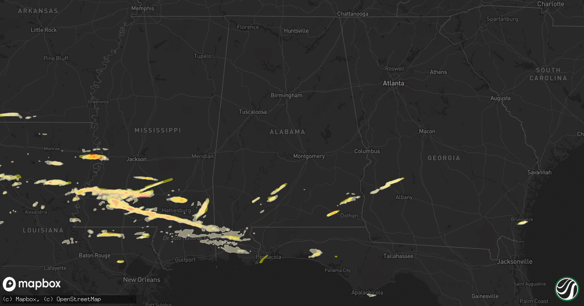
Hail Map in Alabama on March 17, 2016
Get this storm
March 17 map
$229
one time, instant access
Download today. No call, no setup
Keep the $229
Bought the map and want the full workflow? Apply the entire $229 to a subscription within 7 days. None of it is wasted.
Every map, not just this one
This buys you this map. Subscription and you get every map we run, in the markets you choose from a few cities to whole states to nationwide. Plus real-time alerts the moment a storm fires.
Contact data
Name, contact info, occupancy, even credit band for addresses in the footprint. You go from where it hit to who to call.
Become the source they trust
Unlimited branding weather history reports on demand. You already have the documented answer ready for the property owner, and you are the one who showed up with it.
Property data and RoofTrace estimates
Pull up any address you have got, its value and the exact code rules for that jurisdiction, straight from One Click Code. Then RoofTrace estimates the squares, pitch, and roof value, priced the way you price.
Storm reports in Alabama
Alabama
| Date | Description |
|---|---|
| 03/17/20163:05 PM CDT | Several large pine trees snapped and a powerline down. |
| 03/17/20163:00 PM CDT | A local report indicates 1.75 inch wind near DALEVILLE |
| 03/17/20163:00 PM CDT | Photos on social media of hail estimated around quarter size |
| 03/17/20162:13 PM CDT | Tree down on boothtown road near lott road. Time estimated from radar. |
| 03/16/20169:02 PM CDT | Off duty nws employee reports minor roof damage to neighbors home including lost shingles. Time estimated via radar. |
| 03/16/20168:54 PM CDT | Tree on a home at mobile st and white ave resulting in significant damage. Another home in the area suffered shingle damage. Several other trees downed in the area. Num |
| 03/16/20168:46 PM CDT | Resident reports one inch hail just east of the river delta nw of stapleton. |
| 03/16/20168:40 PM CDT | Broadcast media reports hail up to quarter size in spanish fort. |
| 03/16/20168:36 PM CDT | Law enforcement reports an overturned vehicle off yorkhaven rd. |
| 03/16/20168:35 PM CDT | Two 100 year oaks split in half on river forest drive |
| 03/16/20168:28 PM CDT | Resident reports one inch hail just east of the river delta nw of stapleton. Time corrected. |
| 03/16/20168:26 PM CDT | Mobile asos recorded 62mph wind gust with thunderstorm passage. |
| 03/16/20168:20 PM CDT | A section of wood fence downed by thunderstorm winds. |
| 03/16/20168:12 PM CDT | Law enforcement reports quarter inch hail in saraland. |
| 03/16/20168:11 PM CDT | Law enforcement reports tree down on celeste rd. Time estimate from radar. |
All States Impacted by Hail Map on March 17, 2016
Cities Impacted by Hail Map on March 17, 2016
- Simms, TX
- De Kalb, TX
- Delhi, LA
- Lumberton, MS
- Tallulah, LA
- Vicksburg, MS
- Grand Prairie, TX
- Columbia, MS
- Monterey, LA
- Jonesville, LA
- Nocona, TX
- Burnham, ME
- Purvis, MS
- Arlington, TX
- Fort Worth, TX
- Franklinton, LA
- Richton, MS
- Winnfield, LA
- Natchitoches, LA
- Harrisonburg, LA
- Olla, LA
- Brookhaven, MS
- Farmerville, LA
- Princeton, TX
- Mckinney, TX
- Shreveport, LA
- Bossier City, LA
- Leakesville, MS
- Neely, MS
- Beaumont, MS
- State Line, MS
- Lewiston, ME
- Auburn, ME
- Marshall, TX
- Greenwood, LA
- Waskom, TX
- Georgiana, AL
- Beatrice, AL
- Forest Home, AL
- Pine Apple, AL
- Evergreen, AL
- Peterman, AL
- Jayess, MS
- Smithdale, MS
- Kokomo, MS
- Summit, MS
- Meadville, MS
- McCall Creek, MS
- Ruth, MS
- Tylertown, MS
- Bogue Chitto, MS
- Wiggins, MS
- Harrison, ME
- Naples, ME
- Columbia, LA
- Mangham, LA
- Rayville, LA
- McDavid, FL
- Krum, TX
- Decatur, TX
- Campti, LA
- Monticello, MS
- Silver Creek, MS
- Denton, TX
- Ponder, TX
- Pollock, LA
- Dry Prong, LA
- Pineville, LA
- Fairhope, AL
- Silverhill, AL
- Loxley, AL
- Daphne, AL
- Abbeville, AL
- Daleville, AL
- Naples, TX
- Mendenhall, MS
- Braxton, MS
- Texarkana, AR
- El Dorado, AR
- Howe, TX
- Waverly, GA
- Jekyll Island, GA
- Gainesville, TX
- Valley View, TX
- Collinsville, TX
- Sanger, TX
- Tioga, TX
- Era, TX
- Whitesboro, TX
- Springfield, LA
- Gunter, TX
- Repton, AL
- Monroeville, AL
- Plains, GA
- Smithville, GA
- Shellman, GA
- Dawson, GA
- Grand Bay, AL
- Mobile, AL
- Theodore, AL
- Summerdale, AL
- Robertsdale, AL
- Saint Francisville, LA
- Melissa, TX
- Anna, TX
- Blue Ridge, TX
- Little Elm, TX
- Prosper, TX
- Aubrey, TX
- Frisco, TX
- Bennington, OK
- Kennedale, TX
- Foxworth, MS
- Moselle, MS
- Ovett, MS
- Ellisville, MS
- Seminary, MS
- Magee, MS
- Mount Olive, MS
- Freeport, FL
- Santa Rosa Beach, FL
- Tullos, LA
- Leesville, LA
- Castor, LA
- Bienville, LA
- Fort Polk, LA
- Union Church, MS
- Wesson, MS
- Hazlehurst, MS
- Sulphur Springs, TX
- Dike, TX
- Coushatta, LA
- Wolfe City, TX
- Ladonia, TX
- Lewisville, AR
- Enterprise, AL
- Leonard, TX
- Celeste, TX
- Chunchula, AL
- Saraland, AL
- Chatham, LA
- Emerson, AR
- Junction City, AR
- Magnolia, AR
- Fouke, AR
- Doddridge, AR
- Sherman, TX
- Colfax, LA
- Clayton, LA
- Fayette, MS
- Prentiss, MS
- Natchez, MS
- Sontag, MS
- Ferriday, LA
- Palmetto, LA
- Port Barre, LA
- Batchelor, LA
- Melville, LA
- Morganza, LA
- Dallas, TX
- Cedar Hill, TX
- Vidalia, LA
- Waynesboro, MS
- Hattiesburg, MS
- Eastpoint, FL
- Cooper, TX
- Klondike, TX
- Pilot Point, TX
- Poplarville, MS
- Texarkana, TX
- Clinton, LA
- Bokchito, OK
- Forestburg, TX
- Saint Jo, TX
- Rhome, TX
- Burkeville, TX
- Newton, TX
- Lisbon, ME
- Florien, LA
- Many, LA
- Mansfield, LA
- Ozark, AL
- Marksville, LA
- Woodville, MS
- Clio, AL
- Clopton, AL
- Lisbon Falls, ME
- Goldonna, LA
- Robeline, LA
- Atmore, AL
- Roxie, MS
- Farmersville, TX
- Wilmer, AL
- Semmes, AL
- Lucedale, MS
- Vancleave, MS
- Perkinston, MS
- Moss Point, MS
- Atlanta, LA
- Justin, TX
- Americus, GA
- Cuthbert, GA
- Lewisville, TX
- Ruston, LA
- Argyle, TX
- Flower Mound, TX
- Hemphill, TX
- Stamps, AR
- Crystal Springs, MS
- Harrisville, MS
- McLain, MS
- Roanoke, TX
- Greensburg, LA
- Coleman, GA
- Bay Minette, AL
- Gloster, MS
- Citronelle, AL
- Savoy, TX
- Durham, ME
- New Gloucester, ME
- Bowdoin, ME
- Eight Mile, AL
- Mccomb, MS
- Brooklyn, MS
- Sumrall, MS
- New Augusta, MS
- Pinola, MS
- Newhebron, MS
- Tyler, TX
- Jackson, LA
- Provencal, LA
- Collins, MS
- Frisco City, AL
- Haughton, LA
- Princeton, LA
- Annona, TX
- Buckatunna, MS
- Powderly, TX
- Kentwood, LA
- Ethel, LA
- Amite, LA
- Fluker, LA
- Roseland, LA
- Poland, ME
- Valley Park, MS
- Georgetown, MS
- Saline, LA
- Marion, LA
- Newville, AL
- Toomsuba, MS
- Meridian, MS
- Ringgold, LA
- Hall Summit, LA
- Newton, AL
- Chancellor, AL
- Avery, TX
- Laurel, MS
- Lauderdale, MS
- Marion, MS
- Enterprise, LA
- Skipperville, AL
- Midland City, AL
- Paradise, TX
- Angie, LA
- Mount Hermon, LA
- Paris, TX
- Karnack, TX
- Mooringsport, LA
- Van Alstyne, TX
- Rutledge, AL
- Crosby, MS
- Caddo, OK
- Caney, OK
- Bells, TX
- Bonham, TX
- Soso, MS
- Taylorsville, MS
- Blossom, TX
- Aimwell, LA
- Sicily Island, LA
- Kelly, LA
- Maud, TX
- New Boston, TX
- Hooks, TX
- Nash, TX
- Leslie, GA
- Sandy Hook, MS
- Edwards, MS
- Longview, TX
- West Monroe, LA
- Omaha, TX
- Maurepas, LA
- Mechanic Falls, ME
- Mize, MS
- Marietta, TX
- Pelican, LA
- Clinton, ME
- Canaan, ME
- Pensacola, FL
- Axis, AL
- Stapleton, AL
- Satsuma, AL
- Creola, AL
- Clarksville, TX
- Commerce, TX
- Bradley, AR
- Strong, AR
- Vivian, LA
- New Roads, LA
- Monroe, LA
- Raymond, MS
- Bolton, MS
- Liberty, MS
- Madill, OK
- Mead, OK
- Greenville, AL
- Bay Springs, MS
- Lorman, MS
- Sumner, ME
- Turner, ME
- Buckfield, ME
- Leeds, ME
- Minot, ME
- Raymond, ME
- Sabattus, ME
- Oxford, ME
- Topsham, ME
- Casco, ME
- Unity, ME
- Troy, ME
- Pittsfield, ME
- Taylor, AR
- Hornbeck, LA
- Panama City, FL
- Bogalusa, LA
- Aledo, TX
- Naval Air Station Jrb, TX
- Mansfield, TX
- Weatherford, TX
- Azle, TX
- Duncanville, TX
- Wilmer, TX
- Lancaster, TX
- Ferris, TX
- Bridgeport, TX
- Chico, TX
- Thackerville, OK
- Lindsay, TX
- Muenster, TX
- Pecan Gap, TX


