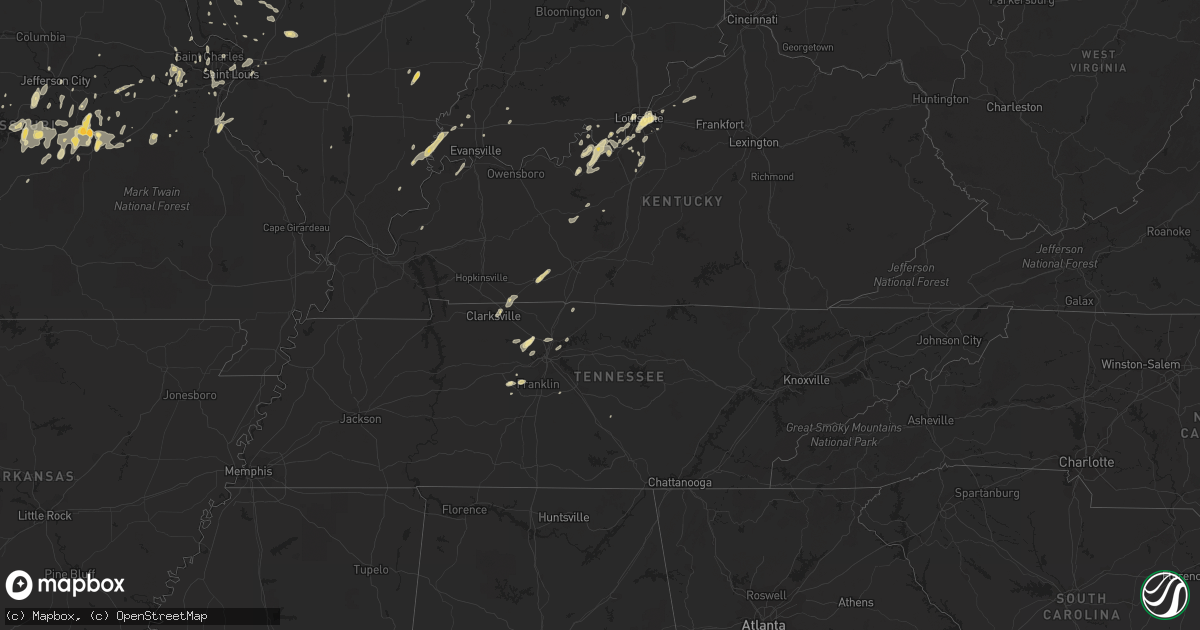
Hail Map in Illinois on March 17, 2012
Get this storm
March 17 map
$229
one time, instant access
Download today. No call, no setup
Keep the $229
Bought the map and want the full workflow? Apply the entire $229 to a subscription within 7 days. None of it is wasted.
Every map, not just this one
This buys you this map. Subscription and you get every map we run, in the markets you choose from a few cities to whole states to nationwide. Plus real-time alerts the moment a storm fires.
Contact data
Name, contact info, occupancy, even credit band for addresses in the footprint. You go from where it hit to who to call.
Become the source they trust
Unlimited branding weather history reports on demand. You already have the documented answer ready for the property owner, and you are the one who showed up with it.
Property data and RoofTrace estimates
Pull up any address you have got, its value and the exact code rules for that jurisdiction, straight from One Click Code. Then RoofTrace estimates the squares, pitch, and roof value, priced the way you price.
Storm reports in Illinois
Illinois
| Date | Description |
|---|---|
| 03/17/201210:21 AM CDT | Hemmingsen road and olson road. |
| 03/17/201210:07 AM CDT | Hemmingsen road and olson road. |
| 03/17/20129:45 AM CDT | A local report indicates 1.00 inch wind near 1 S WOODSTOCK |
| 03/17/20127:35 AM CDT | Hail ranged from half inch to one inch |
| 03/17/20127:10 AM CDT | A local report indicates 1.00 inch wind near BELVIDERE |
| 03/17/20121:30 AM CDT | Report of quarter to half dollar size hail. Report relayed from nws lincoln office. |
| 03/17/201212:45 AM CDT | A local report indicates 1.00 inch wind near 1 SE MACOMB |
| 03/17/201212:44 AM CDT | Hail reports of quarter to half dollar size. |
| 03/17/201212:44 AM CDT | A local report indicates 1.00 inch wind near 1 S MACOMB |
| 03/17/201212:43 AM CDT | A local report indicates 1.50 inch wind near 1 S MACOMB |
| 03/17/201212:43 AM CDT | A local report indicates 1.25 inch wind near 2 SSE MACOMB |
All States Impacted by Hail Map on March 17, 2012
Cities Impacted by Hail Map on March 17, 2012
- Saint Louis, MO
- Saint Charles, MO
- Maryland Heights, MO
- Rushville, IL
- Astoria, IL
- Owensville, MO
- Jacksonville, IL
- Manchester, TN
- Morrison, TN
- Pontiac, IL
- Louisville, KY
- Eldon, MO
- Gerald, MO
- Westphalia, MO
- Saint Thomas, MO
- Jefferson City, MO
- New Haven, MO
- Hermann, MO
- La Prairie, IL
- Lebanon Junction, KY
- Greenfield, IL
- Rockbridge, IL
- White Hall, IL
- Wrights, IL
- Carrollton, IL
- Fieldon, IL
- Jerseyville, IL
- Macomb, IL
- Bardolph, IL
- Bushnell, IL
- Marengo, IL
- Bowman, SC
- Belle, MO
- Vichy, MO
- Vienna, MO
- Columbus, IN
- Macks Creek, MO
- Irvington, KY
- Guston, KY
- Brandenburg, KY
- Mauckport, IN
- Laconia, IN
- Ekron, KY
- Rolla, MO
- Dixon, MO
- Newburg, MO
- Benld, IL
- Sawyerville, IL
- Mount Olive, IL
- Gillespie, IL
- Tuscola, IL
- Neeses, SC
- Payneville, KY
- Webster, KY
- Saint James, MO
- Bland, MO
- Brumley, MO
- Ulman, MO
- Richland, MO
- Litchfield, IL
- Carlinville, IL
- Edwardsville, IL
- Moro, IL
- Genoa, IL
- Camargo, IL
- Villa Grove, IL
- Dix, IL
- Lostant, IL
- Omaha, IL
- Kingston, IL
- Carmi, IL
- Elizabeth, IN
- New Albany, IN
- Shepherdsville, KY
- Sullivan, MO
- Bourbon, MO
- Fairview, TN
- Bon Aqua, TN
- Primm Springs, TN
- Frederick, IL
- Auburn, KY
- Russellville, KY
- Harned, KY
- Hardinsburg, KY
- Stoutland, MO
- Montreal, MO
- Crocker, MO
- Osage Beach, MO
- Saint Elizabeth, MO
- Tuscumbia, MO
- Iberia, MO
- Kaiser, MO
- Sunrise Beach, MO
- Lake Ozark, MO
- Guyton, GA
- Brooklet, GA
- Minonk, IL
- Rutland, IL
- Toluca, IL
- Roodhouse, IL
- Atwood, IL
- Bement, IL
- Masonic Home, KY
- Tennyson, IN
- Avon, IL
- Roseville, IL
- College Grove, TN
- Festus, MO
- Huntley, IL
- Woodstock, IL
- Orangeburg, SC
- Norway, SC
- Onarga, IL
- Hendersonville, TN
- Mount Juliet, TN
- Sorento, IL
- Belvidere, IL
- Garden Prairie, IL
- Poplar Grove, IL
- Carlyle, IL
- Centralia, IL
- Marion, KY
- Chesterfield, IL
- Bowling Green, MO
- Jacksonville, FL
- Pittsfield, IL
- Portland, TN
- Hope, IN
- Odell, IL
- Cornell, IL
- Blackville, SC
- Streator, IL
- Auburn, IL
- Virden, IL
- Divernon, IL
- Murrayville, IL
- Winchester, IL
- Saint Peters, MO
- Camden, IL
- New Harmony, IN
- Mount Vernon, IN
- New Haven, IL
- Raeford, NC
- Clayton, IN
- Plainfield, IN
- Fenton, MO
- Cuba, MO
- Leasburg, MO
- Augusta, MO
- Mulkeytown, IL
- Petersburg, IL
- Pleasant Plains, IL
- Tallula, IL
- Crest Hill, IL
- Joliet, IL
- Norris City, IL
- Ridgway, IL
- New Douglas, IL
- Greenville, IL
- Stover, MO
- Lincoln, MO
- Pewee Valley, KY
- Crestwood, KY
- Arthur, IL
- Wentzville, MO
- Marthasville, MO
- Foristell, MO
- Defiance, MO
- Labadie, MO
- Goodlettsville, TN
- Chamois, MO
- Russellville, MO
- Eugene, MO
- Henley, MO
- Olean, MO
- Medora, IL
- Franklin, TN
- Joelton, TN
- Ashland City, TN
- Wilmington, IL
- Guthrie, KY
- Clarksville, TN
- Linn, MO
- Loose Creek, MO
- Bonnots Mill, MO
- Glenview, KY
- Fairdale, KY
- Mount Erie, IL
- Olney, IL
- Noble, IL
- Corydon, KY
- Henderson, KY
- Waverly, KY
- Evansville, IN
- Berwick, IL
- West Point, KY
- Manhattan, IL
- Peotone, IL
- Barnett, MO
- Battletown, KY
- Hillview, IL
- Pearl, IL
- Barnwell, SC
- Cisne, IL
- Freeburg, MO
- Eminence, KY
- Smithfield, KY
- New Castle, KY
- Hettick, IL
- Villa Ridge, MO
- Gray Summit, MO
- Wenona, IL
- Freetown, IN
- Rhodelia, KY
- Charlotte, TN
- Chapmansboro, TN
- Lockport, IL
- Fairbury, IL
- Adams, TN
- Allensville, KY
- Washington, MO
- Brighton, IL
- Cynthiana, IN
- Tipton, MO
- Fortuna, MO
- Syracuse, MO
- Versailles, MO
- Arenzville, IL
- Beardstown, IL
- Meredosia, IL
- McNabb, IL
- Magnolia, IL
- Tonica, IL
- Portland, MO
- Pacific, MO
- Brinktown, MO
- Steelville, MO
- Leitchfield, KY
- Hampshire, IL
- Union, IL
- Bethalto, IL
- Alton, IL
- Allendale, SC
- Herod, IL
- Galesburg, IL
- Cameron, IL
- Poseyville, IN
- Argyle, MO
- Gravois Mills, MO
- Richwoods, MO
- Pawnee, IL
- Lake Saint Louis, MO
- Alexander, IL
- Granite City, IL
- Waterloo, IL
- Valmeyer, IL
- Herculaneum, MO
- Fults, IL
- Crystal City, MO
- Clarkson, KY
- Hartsburg, MO
- Troy, IL
- Saint Jacob, IL
- Industry, IL
- Georgetown, SC
- Nashville, TN
- Camdenton, MO
- Corydon, IN
- Avon, IN
- Danville, IN
- Cross, SC
- Kankakee, IL
- Arnold, MO
- Janesville, WI
- Vine Grove, KY
- Garfield, KY
- Versailles, IL
- Conway, MO
- Rosebud, MO
- Winslow, IN
- Florissant, MO
- Hazelwood, MO
- Meta, MO
- Caneyville, KY
- Morgantown, KY
- Monticello, IL
- Mount Sterling, IL
- Chapin, IL
- Madison, TN
- Old Hickory, TN
- Worden, IL
- Colchester, IL
- Lohman, MO
- Leavenworth, IN
- Fort Branch, IN
- Owensville, IN
- Whites Creek, TN
- Eldred, IL
- O'Fallon, MO
- Glen Carbon, IL
- Collinsville, IL
- Edwards, MO
- Climax Springs, MO
- Koeltztown, MO
- Holts Summit, MO
- Chandler, IN
- Lebanon, MO
- White Heath, IL
- Santa Fe, TN
- Statesboro, GA
- Elizabethtown, KY
- Waynesville, MO
- Wildwood, MO
- Bryceville, FL
- Brooks, KY
- Franklin, IL
- Caseyville, IL
- Fairview Heights, IL
- Denmark, SC
- Lonedell, MO
- Saint Clair, MO
- Chesterfield, MO


