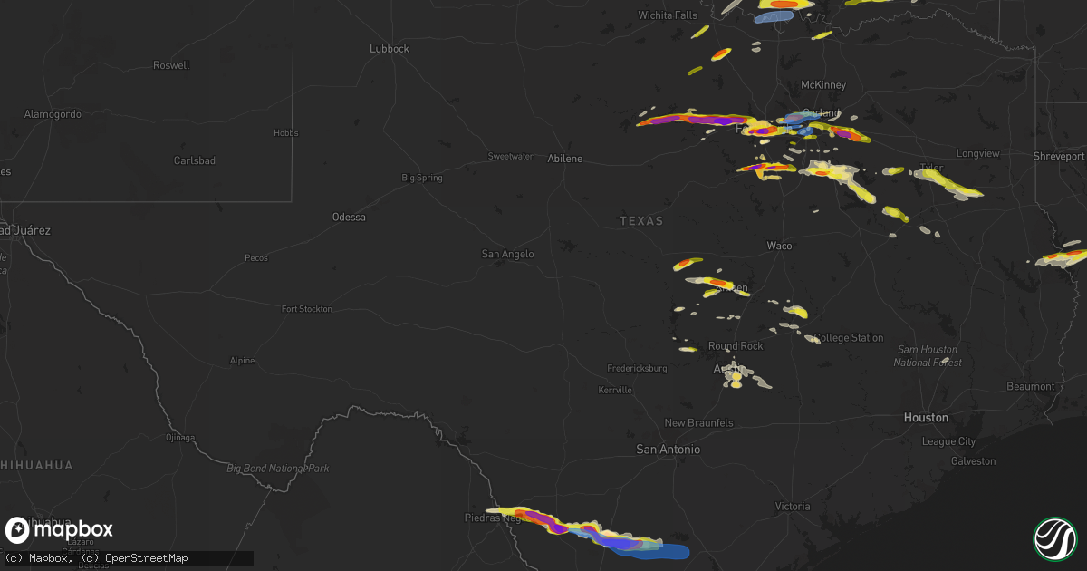
Hail Map in Texas on March 16, 2023
Get this storm
March 16 map
$229
one time, instant access
Download today. No call, no setup
Keep the $229
Bought the map and want the full workflow? Apply the entire $229 to a subscription within 7 days. None of it is wasted.
Every map, not just this one
This buys you this map. Subscription and you get every map we run, in the markets you choose from a few cities to whole states to nationwide. Plus real-time alerts the moment a storm fires.
Contact data
Name, contact info, occupancy, even credit band for addresses in the footprint. You go from where it hit to who to call.
Become the source they trust
Unlimited branding weather history reports on demand. You already have the documented answer ready for the property owner, and you are the one who showed up with it.
Property data and RoofTrace estimates
Pull up any address you have got, its value and the exact code rules for that jurisdiction, straight from One Click Code. Then RoofTrace estimates the squares, pitch, and roof value, priced the way you price.
Storm reports in Texas
Texas
| Date | Description |
|---|---|
| 03/16/20236:58 PM CDT | A local report indicates 1.75 inch wind near BARDWELL |
| 03/16/20236:49 PM CDT | A local report indicates 1.25 inch wind near 1 ESE LAWRENCE |
| 03/16/20236:46 PM CDT | A local report indicates 1.50 inch wind near 2 WSW TERRELL |
| 03/16/20236:39 PM CDT | A local report indicates 1.75 inch wind near 2 S TERRELL |
| 03/16/20236:32 PM CDT | A local report indicates 1.00 inch wind near 4 SW LAWRENCE |
| 03/16/20236:31 PM CDT | A local report indicates 1.50 inch wind near 3 S LAWRENCE |
| 03/16/20236:20 PM CDT | A local report indicates 1.75 inch wind near 2 WSW FORT HOOD |
| 03/16/20236:17 PM CDT | A local report indicates 1.00 inch wind near 3 NE FORT HOOD |
| 03/16/20236:10 PM CDT | A local report indicates 1.00 inch wind near 2 WSW FORT HOOD |
| 03/16/20236:02 PM CDT | A local report indicates 1.00 inch wind near 3 N MAYPEARL |
| 03/16/20235:58 PM CDT | A local report indicates 1.75 inch wind near 4 SE ALVARADO |
| 03/16/20235:50 PM CDT | Townhome complex lost roof... 7 units were impacted. |
| 03/16/20235:50 PM CDT | Corrects previous tstm wnd dmg report from 6 ssw irving. More tree and fence damage on social media. |
| 03/16/20235:45 PM CDT | Corrects previous tstm wnd dmg report from 1 sse irving. Photos on social media show autos of dallas in irving sustained damage to their building and a customers car. |
| 03/16/20235:45 PM CDT | Roof damage to autos of dallas and damage to a customers car. |
| 03/16/20235:35 PM CDT | A local report indicates 1.50 inch wind near 2 NE BENBROOK |
| 03/16/20235:31 PM CDT | A local report indicates 1.00 inch wind near 5 SSE BEDFORD |
| 03/16/20235:30 PM CDT | Tree limbs up to 8 inches in diameter snapped and broken. |
| 03/16/20235:30 PM CDT | Corrects previous tstm wnd dmg report from garland. Neighborhoods sustained fence damage with some trees snapped. |
| 03/16/20235:28 PM CDT | Report from mping: quarter |
| 03/16/20235:23 PM CDT | Corrects previous tstm wnd dmg report from 4 se euless. Downed trees and broken tree limbs. |
| 03/16/20235:20 PM CDT | A local report indicates 2.00 inch wind near 2 NE CLEBURNE |
| 03/16/20235:20 PM CDT | A local report indicates 3.00 inch wind near 3 SSW FORT WORTH |
| 03/16/20235:20 PM CDT | A local report indicates 1.25 inch wind near 4 NW SUNNYVALE |
| 03/16/20235:19 PM CDT | Report from mping: ping pong ball |
| 03/16/20235:17 PM CDT | Report from mping: ping pong ball |
| 03/16/20235:16 PM CDT | Corrects previous hail report from 1 wnw cleburne. |
| 03/16/20235:15 PM CDT | A local report indicates 1.75 inch wind near 2 E CLEBURNE |
| 03/16/20235:14 PM CDT | A local report indicates 1.25 inch wind near 3 S WESTOVER HILLS |
| 03/16/20235:14 PM CDT | Report from mping: quarter |
| 03/16/20235:12 PM CDT | A local report indicates 2.00 inch wind near 2 NNE BENBROOK |
| 03/16/20235:10 PM CDT | A local report indicates 1.00 inch wind near 1 SSW FORT WORTH |
| 03/16/20235:07 PM CDT | A local report indicates 1.75 inch wind near 3 S WESTOVER HILLS |
| 03/16/20235:06 PM CDT | A local report indicates 1.00 inch wind near 3 SSW FORT WORTH |
| 03/16/20235:05 PM CDT | A local report indicates 1.50 inch wind near 3 ENE BENBROOK |
| 03/16/20235:02 PM CDT | A local report indicates 1.25 inch wind near 1 S IRVING |
| 03/16/20235:01 PM CDT | Report from mping: quarter |
| 03/16/20234:59 PM CDT | Report from mping: quarter |
| 03/16/20234:43 PM CDT | Dfw asos recorded a wind gust of 58 mph |
| 03/16/20234:03 PM CDT | Report from mping: quarter |
| 03/16/20233:58 PM CDT | Report from mping: quarter |
| 03/16/20233:54 PM CDT | A local report indicates 3.00 inch wind near 3 NW WEATHERFORD |
| 03/16/20233:52 PM CDT | A local report indicates 1.00 inch wind near 6 SE BOWIE |
| 03/16/20233:48 PM CDT | A local report indicates 1.25 inch wind near 1 ENE LAKESIDE |
| 03/16/20233:44 PM CDT | A local report indicates 1.00 inch wind near 4 E BOWIE |
| 03/16/20233:39 PM CDT | A local report indicates 1.00 inch wind near 8 NNW CHICO |
| 03/16/20233:35 PM CDT | A local report indicates 1.75 inch wind near 3 SSE BOWIE |
| 03/16/20233:33 PM CDT | A local report indicates 2.00 inch wind near 6 N WEATHERFORD |
| 03/16/20233:30 PM CDT | Corrects previous hail report from 2 wnw weatherford. |
| 03/16/20233:30 PM CDT | A local report indicates 2.00 inch wind near 3 NW WEATHERFORD |
| 03/16/20233:30 PM CDT | A local report indicates 1.50 inch wind near 2 WNW WEATHERFORD |
| 03/16/20233:28 PM CDT | A local report indicates 1.50 inch wind near 9 WSW SPRINGTOWN |
| 03/16/20233:27 PM CDT | Report from mping: quarter |
| 03/16/20233:22 PM CDT | Social media photos of tennis ball hail in mineral wells. |
| 03/16/20233:20 PM CDT | Damage to windshield and mirror of a car. |
| 03/16/20233:17 PM CDT | A local report indicates 1.75 inch wind near 1 E COOL |
| 03/16/20233:06 PM CDT | A local report indicates 1.75 inch wind near 3 ENE MINERAL WELLS |
| 03/16/20232:40 PM CDT | Ping pong ball sized hail reported at possum kingdom lake. |
| 03/16/20232:40 PM CDT | A local report indicates 1.50 inch wind near PALO PINTO |
| 03/16/20236:37 AM CDT | Member of the public sent a picture of the roof of a sunoco gas station blown over. |
| 03/16/20234:21 AM CDT | La salle county sherrif reported hail damage to cars including broken windshields. Homes with broken windows. |
| 03/16/20232:10 AM CDT | Corrects previous hail report from 1 n cotulla. La salle county sherrif reported hail damage to cars including broken windshields. Homes with broken windows. |
| 03/16/20232:08 AM CDT | Asos station kcot cotulla. |
| 03/15/202310:05 PM CDT | Tree downed along cr 311 and cr 317 south of henderson... Texas. |
| 03/15/202310:03 PM CDT | Quarter size hail reported via mping in eklhart... Tx. |
| 03/15/20239:45 PM CDT | A local report indicates 1.00 inch wind near 9 WSW HENDERSON |
| 03/15/20239:37 PM CDT | 3 to 8 inch diameter trees blown over. |
| 03/15/20239:07 PM CDT | Also winds estimated at 60 mph at this location. |
| 03/15/20238:00 PM CDT | Extensive tree damage... Camper was overturned... And homes were damaged just north of corsicana. Possible injuries. Follow up will be needed. |
| 03/15/20237:58 PM CDT | A local report indicates 1.00 inch wind near 4 SSW COTTONWOOD |
| 03/15/20237:51 PM CDT | A local report indicates 1.00 inch wind near 6 WSW COPPERAS COVE |
| 03/15/20237:30 PM CDT | Downed trees and broken tree limbs. |
| 03/15/20237:25 PM CDT | More tree and fence damage on social media. |
| 03/15/20237:20 PM CDT | Photos on social media show autos of dallas in irving sustained damage to their building and a customers car. |
| 03/15/20237:20 PM CDT | Neighborhoods sustained fence damage with some trees snapped. |
| 03/15/20237:02 PM CDT | A local report indicates 1.75 inch wind near ALMA |
| 03/15/20237:01 PM CDT | A local report indicates 1.00 inch wind near 5 W VAN |
Cities Impacted by Hail Map on March 16, 2023
- Quanah, TX
- Chillicothe, TX
- Olustee, OK
- Eldorado, OK
- Odell, TX
- Vernon, TX
- Tipton, OK
- Headrick, OK
- Altus, OK
- Snyder, OK
- Elmer, OK
- Frederick, OK
- Hollister, OK
- Loveland, OK
- Indiahoma, OK
- Chattanooga, OK
- Cache, OK
- Faxon, OK
- Lawton, OK
- Geronimo, OK
- Walters, OK
- Breckenridge, TX
- Duncan, OK
- Strawn, TX
- Graford, TX
- Marlow, OK
- Palo Pinto, TX
- Mineral Wells, TX
- Elmore City, OK
- Foster, OK
- Henrietta, TX
- Weatherford, TX
- Bellevue, TX
- Ringgold, TX
- Jacksboro, TX
- Bowie, TX
- Tussy, OK
- Ratliff City, OK
- Poolville, TX
- Hennepin, OK
- Davis, OK
- Wynnewood, OK
- Springtown, TX
- Ringling, OK
- Wilson, OK
- Healdton, OK
- Sulphur, OK
- Fort Worth, TX
- Azle, TX
- Roff, OK
- Stonewall, OK
- Fitzhugh, OK
- Tupelo, OK
- Mill Creek, OK
- Tishomingo, OK
- Overbrook, OK
- Burneyville, OK
- Marietta, OK
- Lone Grove, OK
- Ardmore, OK
- Madill, OK
- Centrahoma, OK
- Milburn, OK
- Gainesville, TX
- Muenster, TX
- Leon, OK
- Whitesboro, TX
- Wapanucka, OK
- Coleman, OK
- Lebanon, OK
- Kingston, OK
- Bedford, TX
- Euless, TX
- Grand Prairie, TX
- Irving, TX
- Dallas, TX
- Atoka, OK
- Aledo, TX
- Naval Air Station Jrb, TX
- Cleburne, TX
- Godley, TX
- Lometa, TX
- Goldthwaite, TX
- Richardson, TX
- Evant, TX
- Lampasas, TX
- Gatesville, TX
- Garland, TX
- Arlington, TX
- Keene, TX
- Alvarado, TX
- Durant, OK
- Caddo, OK
- Bokchito, OK
- Graham, TX
- Loco, OK
- Santo, TX
- Millsap, TX
- Springer, OK
- Davidson, OK
- Cleveland, TX
- Elgin, OK
- Saint Jo, TX
- North Richland Hills, TX
- Hurst, TX
- Sunset, TX
- Haltom City, TX
- Coalgate, OK
- Mountain Park, OK
- Stratford, OK
- Ryan, OK
- Sherman, TX
- Comanche, OK
- Grandview, TX
- Denison, TX
- Bennington, OK
- Kempner, TX
- Copperas Cove, TX
- Maypearl, TX
- Venus, TX
- Midlothian, TX
- Waxahachie, TX
- Mesquite, TX
- Balch Springs, TX
- Sunnyvale, TX
- Boswell, OK
- Fort Hood, TX
- Forney, TX
- Killeen, TX
- Terrell, TX
- Kaufman, TX
- Ennis, TX
- Crandall, TX
- Cedar Hill, TX
- Nolanville, TX
- Wills Point, TX
- Belton, TX
- Lancaster, TX
- Hutchins, TX
- Bronson, TX
- Hemphill, TX
- Milam, TX
- Many, LA
- Florien, LA
- Rice, TX
- Chatfield, TX
- Fisher, LA
- Athens, TX
- Murchison, TX
- Kerens, TX
- Spicewood, TX
- Trinidad, TX
- Brownsboro, TX
- Malakoff, TX
- Cameron, TX
- Gause, TX
- Tyler, TX
- Whitehouse, TX
- Troup, TX
- Arp, TX
- Henderson, TX
- Montalba, TX
- Palestine, TX
- Tennessee Colony, TX
- Price, TX
- Selman City, TX
- Crowley, TX
- Burnet, TX
- Burleson, TX
- Kemp, TX
- Rowlett, TX
- Hugo, OK
- Eustace, TX
- Red Oak, TX
- Palmer, TX
- Scurry, TX
- Rockwall, TX
- Dawson, TX
- Jarrell, TX
- Seagoville, TX
- Rogers, TX
- Marble Falls, TX
- Round Mountain, TX
- Ferris, TX
- Rio Vista, TX
- Pineland, TX
- Provencal, LA
- Robeline, LA
- Joshua, TX
- Mabank, TX
- Powell, TX
- Desoto, TX
- Buckholts, TX
- Florence, TX
- Burlington, TX
- Itasca, TX
- Harker Heights, TX
- Georgetown, TX
- Horseshoe Bay, TX
- Llano, TX
- Kennedale, TX
- Duncanville, TX
- Lillian, TX
- Mansfield, TX
- Granbury, TX
- Colleyville, TX
- Rainbow, TX
- Big Wells, TX
- Asherton, TX
- Cotulla, TX
- Tilden, TX
- Fowlerton, TX
- Calliham, TX
- George West, TX
- Three Rivers, TX
- Zwolle, LA
- Rockdale, TX
- Milano, TX
- Caldwell, TX
- Rusk, TX
- Alto, TX
- Austin, TX
- Buda, TX
- Elkhart, TX
- Laneville, TX
- Chandler, TX
- Eagle Pass, TX
- Thorndale, TX
- Dale, TX
- Manor, TX
- Del Valle, TX
- Elgin, TX
- Flint, TX
- Taylor, TX
- Cedar Creek, TX
- Bastrop, TX
- Crockett, TX
- Soper, OK
- Carrizo Springs, TX
- Crystal City, TX
- Quemado, TX
- Concepcion, TX
- Dilley, TX
- Caddo, TX


