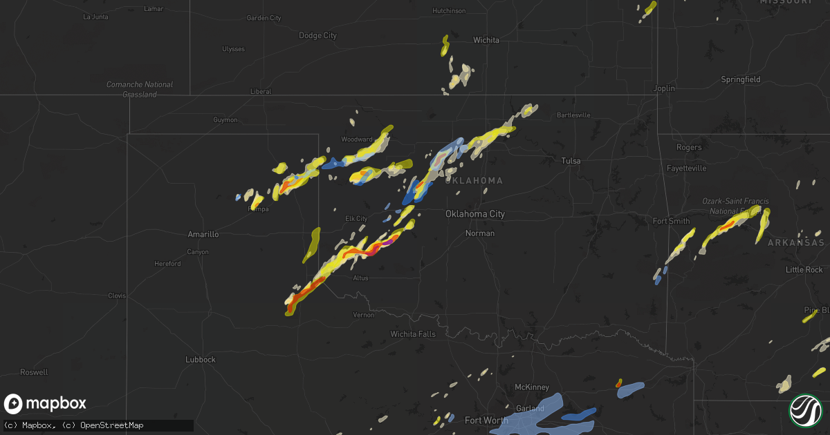
Hail Map in Oklahoma on March 16, 2021
Get this storm
March 16 map
$229
one time, instant access
Download today. No call, no setup
Keep the $229
Bought the map and want the full workflow? Apply the entire $229 to a subscription within 7 days. None of it is wasted.
Every map, not just this one
This buys you this map. Subscription and you get every map we run, in the markets you choose from a few cities to whole states to nationwide. Plus real-time alerts the moment a storm fires.
Contact data
Name, contact info, occupancy, even credit band for addresses in the footprint. You go from where it hit to who to call.
Become the source they trust
Unlimited branding weather history reports on demand. You already have the documented answer ready for the property owner, and you are the one who showed up with it.
Property data and RoofTrace estimates
Pull up any address you have got, its value and the exact code rules for that jurisdiction, straight from One Click Code. Then RoofTrace estimates the squares, pitch, and roof value, priced the way you price.
Storm reports in Oklahoma
Oklahoma
| Date | Description |
|---|---|
| 03/16/20216:56 AM CDT | At 1155 PM CDT, a severe thunderstorm was located near Alfalfa, moving northeast at 20 mph. HAZARD...60 mph wind gusts and quarter size hail. SOURCE...Radar indicated. IMPACT...Hail damage to vehicles is expected. Expect wind damage to roofs, siding, and trees. Locations impacted include... Hinton, Binger, Eakly, Lookeba, Colony, Fort Cobb Reservoir, Alfalfa, Albert and Cowden. |
| 03/16/20216:53 AM CDT | At 1153 PM CDT, a severe thunderstorm was located 6 miles southwest of Canadian, moving northeast at 45 mph. HAZARD...70 mph wind gusts and quarter size hail. SOURCE...Radar indicated. IMPACT...Expect some tree damage. Damage is likely to mobile homes, roofs, and outbuildings. Hail damage to vehicles is expected. Locations impacted include... Lipscomb, Canadian, Follett, Higgins, Lora, Glazier and Lake Marvin. |
| 03/16/20216:47 AM CDT | At 1147 PM CDT, severe thunderstorms were located along a line extending from 6 miles northwest of Lipscomb to near Higgins to 7 miles northwest of Durham, moving northeast at 40 mph. HAZARD...60 mph wind gusts and quarter size hail. SOURCE...Radar indicated. IMPACT...Hail damage to vehicles is expected. Expect wind damage to roofs, siding, and trees. Locations impacted include... Woodward, Shattuck, Arnett, Gage, Fargo, Fort Supply, May, Harmon, Tangier and Catesby. |
| 03/16/20216:40 AM CDT | At 1140 PM CDT, a severe thunderstorm was located 4 miles west of Cloud Chief, moving northeast at 25 mph. HAZARD...Ping pong ball size hail and 60 mph wind gusts. SOURCE...Radar indicated. IMPACT...People and animals outdoors will be injured. Expect hail damage to roofs, siding, windows, and vehicles. Expect wind damage to roofs, siding, and trees. Locations impacted include... Cordell, Corn, Colony, Cloud Chief and Cowden. |
| 03/16/20216:32 AM CDT | At 1132 PM CDT, severe thunderstorms were located along a line extending from 6 miles southeast of Alabaster Caverns State Park to 7 miles east of Quinlan to near Chester, moving east at 35 mph. HAZARD...70 mph wind gusts and quarter size hail. SOURCE...Radar indicated. IMPACT...Hail damage to vehicles is expected. Expect considerable tree damage. Wind damage is also likely to mobile homes, roofs, and outbuildings. Locations impacted include... Alva, Fairview, Cherokee, Helena, Waynoka, Ringwood, Carmen, Cleo Springs, Aline, Dacoma, Lambert, Quinlan, Orion, Chester, Avard, Orienta, Ingersoll, Hopeton and Bouse Junction. |
| 03/16/20216:08 AM CDT | At 1107 PM CDT, a severe thunderstorm was located 12 miles southeast of Wolf Creek Park, or 13 miles northwest of Canadian, moving northeast at 40 mph. HAZARD...60 mph wind gusts and quarter size hail. SOURCE...Radar indicated. IMPACT...Minor damage to roofs, siding, and trees is possible. Hail damage to vehicles is expected. Hail may accumulate on roadways causing hazardous travel. Locations impacted include... Lipscomb, Canadian, Higgins, Darrouzett, Wolf Creek Park, Glazier and Lake Marvin. |
| 03/16/20215:56 AM CDT | At 1055 PM CDT, a severe thunderstorm was located near Hobart, moving east at 25 mph. HAZARD...Tennis ball size hail and 60 mph wind gusts. SOURCE...Trained weather spotters reported tennis ball size hail in Hobart. IMPACT...People and animals outdoors will be injured. Expect hail damage to roofs, siding, windows, and vehicles. Expect wind damage to roofs, siding, and trees. Locations impacted include... Hobart, Sentinel, Mountain View, Gotebo, Rocky, Cloud Chief and Cowden. |
| 03/16/20215:45 AM CDT | At 1045 PM CDT, a severe thunderstorm was located 6 miles east of Harmon, moving east at 30 mph. HAZARD...Ping pong ball size hail and 60 mph wind gusts. SOURCE...Radar indicated. IMPACT...People and animals outdoors will be injured. Expect hail damage to roofs, siding, windows, and vehicles. Expect wind damage to roofs, siding, and trees. Locations impacted include... Mooreland, Seiling, Vici, Sharon, Mutual, Chester, Quinlan, Orion, Cestos and Bouse Junction. |
| 03/16/20215:43 AM CDT | At 1043 PM CDT, severe thunderstorms were located along a line extending from near Corn to 3 miles west of Cordell, moving northeast at 20 mph. HAZARD...60 mph wind gusts and penny size hail. SOURCE...Radar indicated. IMPACT...Expect damage to roofs, siding, and trees. Locations impacted include... Weatherford, Clinton, Cordell, Hinton, Geary, Hydro, Dill City, Corn, Bessie, Bridgeport and Greenfield. |
| 03/16/20215:12 AM CDT | At 1012 PM CDT, a severe thunderstorm was located 5 miles south of Lone Wolf, moving east at 25 mph. HAZARD...Golf ball size hail and 60 mph wind gusts. SOURCE...Radar indicated. IMPACT...People and animals outdoors will be injured. Expect hail damage to roofs, siding, windows, and vehicles. Expect wind damage to roofs, siding, and trees. Locations impacted include... Hobart, Granite, Lone Wolf, Roosevelt, Gotebo, Cooperton and Altus-Lugert Lake. |
| 03/16/20215:11 AM CDT | At 1011 PM CDT, severe thunderstorms were located along a line extending from near Shattuck to near Arnett to 12 miles north of Crawford, moving east at 20 mph. HAZARD...60 mph wind gusts and quarter size hail. SOURCE...Radar indicated. IMPACT...Hail damage to vehicles is expected. Expect wind damage to roofs, siding, and trees. Locations impacted include... Shattuck, Arnett, Gage, Fargo and Harmon. |
| 03/16/20215:06 AM CDT | At 1006 PM CDT, a severe thunderstorm was located 4 miles southeast of Willow, moving northeast at 20 mph. HAZARD...Ping pong ball size hail and 60 mph wind gusts. SOURCE...Radar indicated. IMPACT...People and animals outdoors will be injured. Expect hail damage to roofs, siding, windows, and vehicles. Expect wind damage to roofs, siding, and trees. Locations impacted include... Hobart, Granite, Sentinel, Lone Wolf, Willow, Retrop, Brinkman and Altus-Lugert Lake. |
| 03/16/20214:55 AM CDT | At 954 PM CDT, a severe thunderstorm was located 7 miles south of Higgins, moving northeast at 25 mph. HAZARD...60 mph wind gusts and quarter size hail. SOURCE...Radar indicated. IMPACT...Hail damage to vehicles is expected. Expect wind damage to roofs, siding, and trees. Locations impacted include... Arnett. |
| 03/16/20214:33 AM CDT | At 933 PM CDT, a severe thunderstorm was located near Higgins, moving northeast at 25 mph. HAZARD...60 mph wind gusts and quarter size hail. SOURCE...Radar indicated. IMPACT...Hail damage to vehicles is expected. Expect wind damage to roofs, siding, and trees. Locations impacted include... Shattuck. |
| 03/16/20214:32 AM CDT | At 932 PM CDT, a severe thunderstorm was located over Higgins, or 14 miles southwest of Shattuck, moving northeast at 30 mph. HAZARD...Quarter size hail. SOURCE...Radar indicated. IMPACT...Damage to vehicles is expected. Locations impacted include... Higgins. |
| 03/16/20214:29 AM CDT | At 929 PM CDT, a severe thunderstorm was located 7 miles west of Mangum, moving northeast at 25 mph. HAZARD...Golf ball size hail and 60 mph wind gusts. SOURCE...Trained weather spotters. IMPACT...People and animals outdoors will be injured. Expect hail damage to roofs, siding, windows, and vehicles. Expect wind damage to roofs, siding, and trees. Locations impacted include... Granite, Willow and Brinkman. |
| 03/16/20214:27 AM CDT | At 927 PM CDT, a severe thunderstorm was located near Higgins, or 14 miles southeast of Lipscomb, moving northeast at 30 mph. HAZARD...Quarter size hail. SOURCE...Radar indicated. IMPACT...Damage to vehicles is expected. Locations impacted include... Follett and Higgins. |
| 03/16/20214:15 AM CDT | A local report indicates 60 MPH wind near BURBANK |
| 03/16/20214:12 AM CDT | At 912 PM CDT, a severe thunderstorm was located near Canadian, moving northeast at 45 mph. HAZARD...60 mph wind gusts and quarter size hail. SOURCE...Radar indicated. IMPACT...Minor damage to roofs, siding, and trees is possible. Hail damage to vehicles is expected. Locations impacted include... Lipscomb, Canadian, Glazier and Lake Marvin. |
| 03/16/20213:47 AM CDT | At 847 PM CDT, a severe thunderstorm was located near Gould, moving northeast at 40 mph. HAZARD...60 mph wind gusts and quarter size hail. SOURCE...Radar indicated. IMPACT...Hail damage to vehicles is expected. Expect wind damage to roofs, siding, and trees. Locations impacted include... Mangum, Hollis, Granite, Martha, Willow, Gould, Duke, Brinkman, Hester, McKnight, McQueen and northwestern Altus-Lugert Lake. |
| 03/16/20213:19 AM CDT | At 819 PM CDT, a severe thunderstorm was located 9 miles south of Texola, moving northeast at 55 mph. HAZARD...60 mph wind gusts and quarter size hail. SOURCE...Radar indicated. IMPACT...Hail damage to vehicles is expected. Expect wind damage to roofs, siding, and trees. Locations impacted include... Erick, Sweetwater and Texola. |
| 03/16/20213:09 AM CDT | Report from mping: quarter |
| 03/16/20213:02 AM CDT | At 802 PM CDT, a severe thunderstorm was located over Wellington, moving north at 40 mph. HAZARD...70 mph wind gusts and ping pong ball size hail. SOURCE...Public. IMPACT...Expect some tree damage. Damage is likely to mobile homes, roofs, and outbuildings. People and animals outdoors will be injured. Expect hail damage to roofs, siding, windows, and vehicles. Locations impacted include... Wellington, Samnorwood and Lutie. |
| 03/16/20212:45 AM CDT | At 744 PM CDT, a severe thunderstorm was located 4 miles east of Tell, or 5 miles southwest of Childress, moving northeast at 25 mph. HAZARD...60 mph wind gusts and quarter size hail. SOURCE...Radar indicated. IMPACT...Hail damage to vehicles is expected. Expect wind damage to roofs, siding, and trees. Locations impacted include... Childress, Tell and Kirkland. |
| 03/16/20212:21 AM CDT | At 721 PM CDT, a severe thunderstorm was located 4 miles west of Childress, moving northeast at 45 mph. HAZARD...Golf ball size hail and 60 mph wind gusts. SOURCE...Radar indicated. IMPACT...People and animals outdoors will be injured. Expect hail damage to roofs, siding, windows, and vehicles. Expect wind damage to roofs, siding, and trees. Locations impacted include... Childress, Cee Vee, Tell and Estelline. |
| 03/16/20211:50 AM CDT | A local report indicates 59 MPH wind near 3 NE CLINTON |
| 03/16/20211:25 AM CDT | A local report indicates 1.75 inch wind near 6 W BISON |
| 03/16/20211:16 AM CDT | Twitter report with photo. |
| 03/16/202112:00 AM CDT | Cemented fences down... Anchored carport destroyed... Suv totalled... Time is radar estimate. |
| 03/16/202112:00 AM CDT | A local report indicates 1.25 inch wind near 3 ENE COWDEN |
| 03/15/202111:42 PM CDT | A local report indicates 1.50 inch wind near 7 N MOUNTAIN VIEW |
| 03/15/202111:20 PM CDT | A local report indicates 62 MPH wind near 7 WNW SEILING |
| 03/15/202111:15 PM CDT | Twitter photo of wind turbine damage east of arnett. Time estimate. |
| 03/15/202111:15 PM CDT | A local report indicates 72 MPH wind near 7 WNW SEILING |
| 03/15/202110:55 PM CDT | Brief tornado. |
| 03/15/202110:40 PM CDT | A local report indicates 2.50 inch wind near HOBART |
| 03/15/202110:35 PM CDT | A local report indicates 63 MPH wind near 4 WSW WEATHERFORD |
| 03/15/202110:30 PM CDT | A local report indicates 58 MPH wind near 4 WSW WEATHERFORD |
| 03/15/202110:27 PM CDT | A local report indicates 1.75 inch wind near 4 ENE LONE WOLF |
| 03/15/202110:05 PM CDT | A local report indicates 1.75 inch wind near 1 E BRINKMAN |
| 03/15/202110:00 PM CDT | Numerous power poles and trees down. Also damage to wind turbine at wind farm. |
| 03/15/202110:00 PM CDT | A local report indicates 1.00 inch wind near 4 N MANGUM |
| 03/15/20219:58 PM CDT | A local report indicates 1.00 inch wind near 4 SSE BRINKMAN |
| 03/15/20219:30 PM CDT | A local report indicates 1.00 inch wind near 3 WNW MANGUM |
| 03/15/20219:25 PM CDT | A local report indicates 1.75 inch wind near 1 W MANGUM |
| 03/15/20219:25 PM CDT | A local report indicates 1.00 inch wind near 10 E VINSON |
All States Impacted by Hail Map on March 16, 2021
Cities Impacted by Hail Map on March 16, 2021
- Holly Springs, MS
- Priddy, TX
- Goldthwaite, TX
- Gustine, TX
- Brownwood, TX
- Comanche, TX
- Early, TX
- Mullin, TX
- Hamilton, TX
- Blanket, TX
- Zephyr, TX
- Valera, TX
- Talpa, TX
- Coleman, TX
- Rockwood, TX
- Santa Anna, TX
- Mansfield, AR
- Fort Smith, AR
- Huntington, AR
- Greenwood, AR
- Booneville, AR
- Mangum, OK
- Fulton, KS
- Prescott, KS
- Mapleton, KS
- Pelsor, AR
- Dover, AR
- Hector, AR
- Batesville, MS
- Courtland, MS
- Magazine, AR
- Paint Rock, TX
- Rowena, TX
- San Angelo, TX
- Miles, TX
- Voss, TX
- May, TX
- Bangs, TX
- Gouldbusk, TX
- Ballinger, TX
- Sidney, TX
- El Dorado, AR
- Carlsbad, TX
- Hitchcock, OK
- Kingfisher, OK
- Hennessey, OK
- Bison, OK
- Okeene, OK
- Watonga, OK
- Ames, OK
- Waukomis, OK
- Geary, OK
- Loyal, OK
- Drummond, OK
- Greenfield, OK
- Miami, TX
- Pampa, TX
- Taloga, OK
- Leedey, OK
- Camargo, OK
- Canadian, TX
- Sharon, OK
- Arnett, OK
- Hollis, OK
- Higgins, TX
- Hazlehurst, MS
- Georgetown, MS
- Subiaco, AR
- New Blaine, AR
- Scranton, AR
- Paris, AR
- Delaware, AR
- Lamar, AR
- London, AR
- Russellville, AR
- Knoxville, AR
- Alligator, MS
- Milan, KS
- Argonia, KS
- Conway Springs, KS
- Winnsboro, LA
- Marks, MS
- Crenshaw, MS
- Lambert, MS
- Sardis, MS
- Manchester, OK
- Anthony, KS
- Calion, AR
- Hampton, AR
- Hydro, OK
- Carnegie, OK
- Canute, OK
- Dill City, OK
- Clarksdale, MS
- Delhi, LA
- Sondheimer, LA
- Epps, LA
- Red Rock, OK
- Atkins, AR
- Lone Wolf, OK
- Hobart, OK
- Gotebo, OK
- Mineral Wells, TX
- Santo, TX
- Jacksboro, TX
- Burleson, TX
- Godley, TX
- Cleburne, TX
- Joshua, TX
- Americus, KS
- Allen, KS
- Dumas, AR
- Watson, AR
- Olla, LA
- Winnfield, LA
- Sikes, LA
- Wellington, TX
- Mount Vernon, AR
- Romance, AR
- Breckenridge, TX
- Pawnee, OK
- Corn, OK
- Willow, OK
- Pottsville, TX
- Mereta, TX
- Brookesmith, TX
- Novice, TX
- Mutual, OK
- Mooreland, OK
- Gould, OK
- Childress, TX
- Blue Mound, KS
- Mound City, KS
- Winters, TX
- New Edinburg, AR
- Hartford, AR
- Waldron, AR
- Charleston, AR
- Hermitage, AR
- Wilmar, AR
- Burlingame, KS
- Chilhowee, MO
- Clinton, MO
- Blairstown, MO
- Osage City, KS
- Cisco, TX
- Rising Star, TX
- Cross Plains, TX
- Seiling, OK
- Calhoun, MO
- Ozona, TX
- Caldwell, KS
- Freeport, KS
- Bluff City, KS
- Vinson, OK
- Perryton, TX
- Granite, OK
- Kosciusko, MS
- Lauderdale, MS
- Sterling City, TX
- Mertzon, TX
- Butler, MO
- Weatherford, OK
- Okarche, OK
- Piedmont, OK
- Weatherford, TX
- Borger, TX
- Skellytown, TX
- Oxford, MS
- Chester, OK
- Dover, OK
- Wesson, MS
- Tichnor, AR
- Shattuck, OK
- Kingman, KS
- Spivey, KS
- Murdock, KS
- Leslie, AR
- Duncan, MS
- Gunnison, MS
- Irving, TX
- Coppell, TX
- Dallas, TX
- Cuba, AL
- Ethel, MS
- Sallis, MS
- McCool, MS
- Buffalo, OK
- Cordell, OK
- Lookeba, OK
- Binger, OK
- Lyon, MS
- Onia, AR
- Fox, AR
- Timbo, AR
- Rocky, OK
- Mountain View, OK
- Sentinel, OK
- Perrin, TX
- Bridgeport, TX
- Millsap, TX
- Matador, TX
- Tell, TX
- Paducah, TX
- Covington, OK
- Lucien, OK
- Perry, OK
- Grady, AR
- Gillett, AR
- Star City, AR
- Gould, AR
- Tillar, AR
- Rison, AR
- Pickens, AR
- Colony, OK
- Lake Providence, LA
- Pioneer, LA
- Norwich, KS
- Sledge, MS
- Decatur, TX
- Douglas, OK
- Marshall, OK
- Marland, OK
- Ralston, OK
- Ponca City, OK
- Orlando, OK
- Burbank, OK
- Billings, OK
- Fairmont, OK
- Garber, OK
- Clarksburg, MO
- Byhalia, MS
- Moran, TX
- Isabella, OK
- Collins, MO
- Osceola, MO
- Clyde, TX
- Enid, OK
- Meridian, MS
- Vici, OK
- Snow Lake, AR
- Gainesville, TX
- Sanger, TX
- Mayfield, KS
- Coldwater, MS
- Crawford, OK
- Conway, AR
- Pottsville, AR
- Dardanelle, AR
- Pine Bluff, AR
- Grapevine, AR
- Shidler, OK
- Kaw City, OK
- Thomas, OK
- Toomsuba, MS
- Canton, OK
- Alvord, TX
- Melvin, TX
- Mountain View, AR
- Pinola, MS
- Uniontown, KS
- Redfield, KS
- Coffeeville, MS
- Desdemona, TX
- Dublin, TX
- Burkett, TX
- Bronte, TX
- Daleville, MS
- York, AL
- Star, TX
- Camden, AR
- Sparkman, AR
- Newhebron, MS
- Fountain Hill, AR
- Granbury, TX
- Stephenville, TX
- Edmond, OK
- Arcadia, OK
- Guthrie, OK
- Senatobia, MS
- Heavener, OK
- Bailey, MS
- Abilene, TX
- Wellington, KS
- Vance, MS
- Tutwiler, MS
- Randolph, MS
- Carbon, TX
- Eastland, TX
- De Leon, TX
- Iraan, TX
- Carter, OK
- Banner, MS
- Danville, KS
- Harper, KS
- Fort Necessity, LA
- Baskin, LA
- Hodgen, OK
- Tuscumbia, MO
- Oakwood, OK
- Vilonia, AR
- Hinton, OK
- Big Creek, MS
- Calhoun City, MS
- Tullos, LA
- Grayson, LA
- Dyess Afb, TX
- San Saba, TX
- Cole Camp, MO
- Whitesboro, TX
- Elaine, AR
- Scranton, KS
- Graford, TX
- Big Lake, TX
- Dodson, TX
- Cheyenne, OK
- Casa, AR
- Hattieville, AR
- Greenbrier, AR
- Fay, OK
- Montrose, MO
- Como, MS
- Mora, MO
- Monticello, AR
- Warren, AR
- Eudora, AR
- Oak Grove, LA
- Jerusalem, AR
- Smithville, OK
- Omega, OK
- Arapaho, OK
- Clinton, OK
- Cee Vee, TX
- Texola, OK
- Erick, OK
- Shamrock, TX
- Florence, TX
- Salado, TX
- Talco, TX
- Mount Vernon, TX
- Greenville, AL
- Fort Deposit, AL
- Waynoka, OK
- Longdale, OK
- Fairview, OK
- Doole, TX
- Lohn, TX
- Eden, TX
- Eola, TX
- Millersview, TX
- Rochelle, TX
- Wall, TX
- Vancourt, TX
- Gorman, TX
- Morgan, TX
- Hico, TX
- Kopperl, TX
- Iredell, TX
- Walnut Springs, TX
- Glen Rose, TX
- Nemo, TX
- Rainbow, TX
- Tolar, TX
- Bluff Dale, TX
- Garland, TX
- Balch Springs, TX
- Grand Prairie, TX
- Cedar Hill, TX
- Ferris, TX
- Canton, TX
- Red Oak, TX
- Edgewood, TX
- Wills Point, TX
- Kemp, TX
- Hutchins, TX
- Mesquite, TX
- Fort Worth, TX
- Caddo Mills, TX
- Greenville, TX
- Arlington, TX
- Alba, TX
- Rowlett, TX
- Kennedale, TX
- Desoto, TX
- Nevada, TX
- Rockwall, TX
- Quinlan, TX
- Midlothian, TX
- Kaufman, TX
- Grand Saline, TX
- Seagoville, TX
- Royse City, TX
- Terrell, TX
- Sunnyvale, TX
- Venus, TX
- Lancaster, TX
- Duncanville, TX
- Palmer, TX
- Crandall, TX
- Fruitvale, TX
- Mabank, TX
- Mansfield, TX
- Wilmer, TX
- Forney, TX
- Lavon, TX
- Yantis, TX
- Emory, TX
- Point, TX
- Omaha, TX
- Winfield, TX
- Cookville, TX
- Scroggins, TX
- Pittsburg, TX
- Mount Pleasant, TX
- Greenville, MS
- Glen Allan, MS
- Chatham, MS
- Pittsboro, MS
- Bruce, MS
- Pretty Prairie, KS
- Admire, KS
- Emporia, KS
- Reading, KS
- Carbondale, KS
- Overbrook, KS
- Lyndon, KS
- Maple Hill, KS
- Harveyville, KS
- Eskridge, KS
- Topeka, KS
- Pleasanton, KS
- Urich, MO
- Leeton, MO


