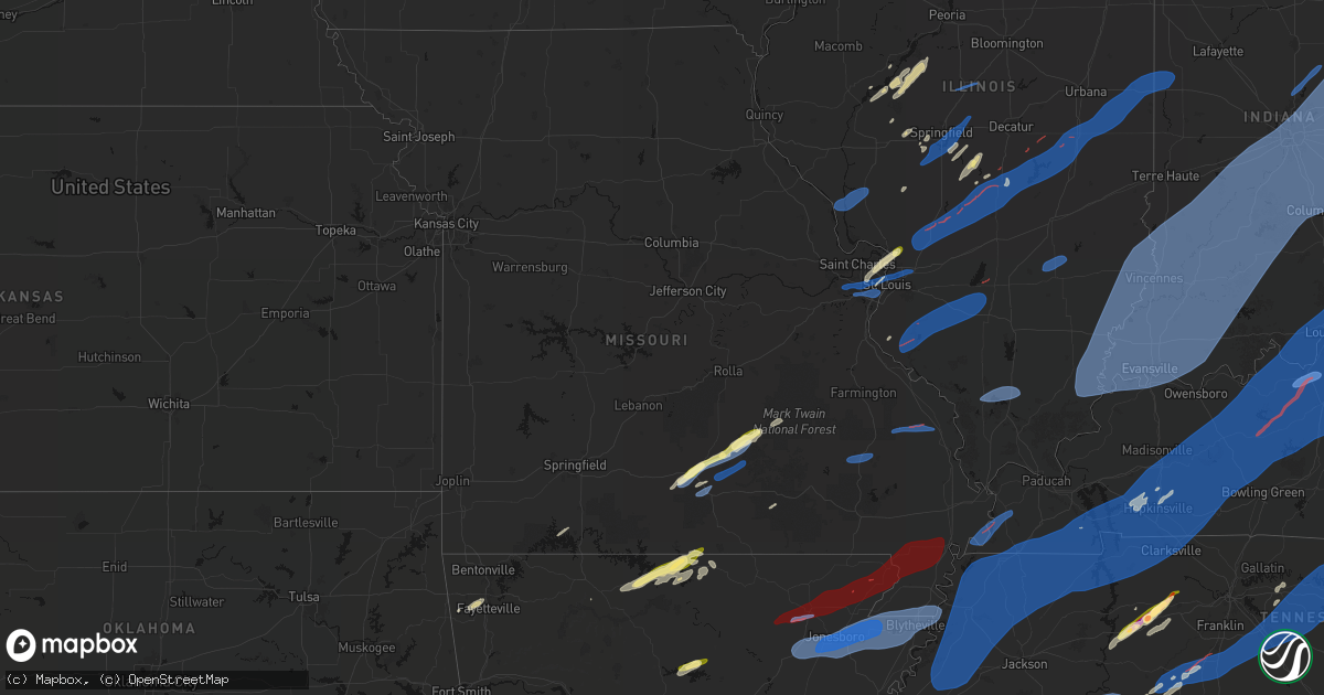
Hail Map in Missouri on March 15, 2026
Get this storm
March 15 map
$229
one time, instant access
Download today. No call, no setup
Keep the $229
Bought the map and want the full workflow? Apply the entire $229 to a subscription within 7 days. None of it is wasted.
Every map, not just this one
This buys you this map. Subscription and you get every map we run, in the markets you choose from a few cities to whole states to nationwide. Plus real-time alerts the moment a storm fires.
Contact data
Name, contact info, occupancy, even credit band for addresses in the footprint. You go from where it hit to who to call.
Become the source they trust
Unlimited branding weather history reports on demand. You already have the documented answer ready for the property owner, and you are the one who showed up with it.
Property data and RoofTrace estimates
Pull up any address you have got, its value and the exact code rules for that jurisdiction, straight from One Click Code. Then RoofTrace estimates the squares, pitch, and roof value, priced the way you price.
Storm reports in Missouri
Missouri
| Date | Description |
|---|---|
| 03/15/20266:48 PM CDT | Several reports of structure damage in clarkton. |
| 03/15/20266:47 PM CDT | Trees down... Powerlines down. Clarkton is without power. |
| 03/15/20266:39 PM CDT | Power poles downed near the intersection of hwy 61 and hwy cc. |
| 03/15/20266:32 PM CDT | A brief ef1 tornado touched down just east of i-55 along county road 510. A couple mobile homes suffered significant roof damage along with one being shifted off its fo |
| 03/15/20266:30 PM CDT | Trees damaged and along with a small shed. |
| 03/15/20266:20 PM CDT | County road 216 blocked by trees and county road 218 blocked by a shed. Time estimated by radar. |
| 03/15/20266:19 PM CDT | An ef-1 tornado touched down just north of hwy 72 about 2 miles southwest of sedgewickville. Several outbuildings or barns suffered some degree of damage... Ranging fro |
| 03/15/20266:09 PM CDT | Roof blown off a mobile home... Time estimated by radar and video of damage. |
| 03/15/20266:06 PM CDT | Report of a tree down blocking the road... Time estimated by radar. |
| 03/15/20266:05 PM CDT | Outbuilding collapsed at buckhorn general baptist church. |
| 03/15/20265:52 PM CDT | Some barns and outbuildings damaged in lodi. Time estimated from radar. |
| 03/15/20265:50 PM CDT | Multiple trees downed near sam a baker state park. |
| 03/15/20265:19 PM CDT | Couple trees down at the junction of hwy c and hwy f near eastwood. |
| 03/15/20265:15 PM CDT | Tree debris is blocking a part of hwy d just north of hwy o. Time of damage estimated from radar. |
| 03/15/20265:08 PM CDT | Rotating wall cloud or funnel cloud photographed prior to a car port being lifted and set upon a house. In addition... A row of power lines was bent over. |
| 03/15/20265:01 PM CDT | Up to 8-inch tree limbs down along green park industrial drive. |
| 03/15/20264:58 PM CDT | Report via email of two uprooted trees at a home in alton. Time estimated from radar. |
| 03/15/20264:55 PM CDT | Two to three inch limbs down. Time based on radar estimate. |
| 03/15/20264:53 PM CDT | Bradford pear tree was split in two... With a third of the tree and a 12-inch limb laid across the yard. |
| 03/15/20264:45 PM CDT | Winds blew open strong steel door... Estimated at 70 mph. |
| 03/15/20264:30 PM CDT | Report of wind damage at west plains racetrack. Time estimated from radar. |
| 03/15/20264:28 PM CDT | A barn roof had damage on county road 9030 about 6 miles south of west plains. |
| 03/15/20264:18 PM CDT | A local report indicates 60 MPH wind near 1 N Farmington |
| 03/15/20264:11 PM CDT | Multiple reports of 1.00 inch hail in the akers area. No other damage reported in this area. |
| 03/15/20264:09 PM CDT | Emergency management sent in pictures of structural damage to a church and surrounding houses just northwest of summersville. The churchs foundation was lifted off the |
| 03/15/20264:05 PM CDT | Tree down in washington. |
| 03/15/20264:05 PM CDT | Tree down in union. |
| 03/15/20264:03 PM CDT | Tree down into a house in sullivan. |
| 03/15/20264:00 PM CDT | From x.com... Picture of tree down onto east vine street near sullivan country club. |
| 03/15/20263:58 PM CDT | A large tree fell near the montauk state park campground. |
| 03/15/20263:50 PM CDT | Video report of wind overturning a barn and taking down trees on a home security system. Time estimated from radar. |
| 03/15/20263:39 PM CDT | Tree down on east cherry street with live power lines on the roadway. |
| 03/15/20263:38 PM CDT | Delayed report with time approximated from radar. Emergency management reported damage to a metal outbuilding northeast of cabool. Pictures sent in showed the walls col |
| 03/15/20263:28 PM CDT | Multiple reports were received of trees down in in several locations in douglas county. Reports occurred at county road 206 off of ff highway and county road 307 off of |
| 03/15/20263:24 PM CDT | A tree limb snapped off and was partially in the roadway. Time estimated via radar. |
| 03/15/20263:02 PM CDT | Trees down county road 206 off of ff highway. |
| 03/15/20263:00 PM CDT | Corrects previous tstm wnd dmg report from 2 nw squires. Multiple reports were received of trees down in in several locations in douglas county.â reports occurred at c |
| 03/15/20262:30 PM CDT | A large 2 to 3 foot diameter tree was down across both lanes of traffic on harris boulevard at douglas fir road. |
| 03/15/20261:02 PM CDT | Report of limb on top of house with damage to guttering and chain-link fence. |
All States Impacted by Hail Map on March 15, 2026
Cities Impacted by Hail Map on March 15, 2026
- Woodburn, IA
- Osceola, IA
- Alexander, IL
- Ashland, IL
- New Berlin, IL
- Pleasant Plains, IL
- Beardstown, IL
- Hettick, IL
- Palmyra, IL
- Bath, IL
- Kilbourne, IL
- Havana, IL
- Chandlerville, IL
- Easton, IL
- Lewistown, IL
- Browning, IL
- Springfield, IL
- Forest City, IL
- Manito, IL
- Mason City, IL
- Riverside, IA
- Kalona, IA
- Iowa City, IA
- Hills, IA
- Lincoln, AR
- Fayetteville, AR
- Summers, AR
- Prairie Grove, AR
- Farmington, AR
- Springdale, AR
- Okeechobee, FL
- Palm Bay, FL
- Lorida, FL
- Kimberling City, MO
- Reeds Spring, MO
- Fellsmere, FL
- Punta Gorda, FL
- Fort Meade, FL
- Lake Wales, FL
- Frostproof, FL
- Malabar, FL
- Dade City, FL
- Grant, FL
- Wesley Chapel, FL
- San Antonio, FL
- Land O'Lakes, FL
- Melbourne, FL
- Washington, IA
- West Branch, IA
- Spring Hill, FL
- Brooksville, FL
- Bartow, FL
- Wauchula, FL
- Broken Bow, OK
- Davenport, FL
- Kissimmee, FL
- Sebastian, FL
- Harrison, AR
- Bowling Green, FL
- Webster, FL
- Ona, FL
- Parrish, FL
- Eagletown, OK
- Haines City, FL
- Polk City, FL
- Idabel, OK
- Garvin, OK
- Mountain Grove, MO
- Cabool, MO
- Yellville, AR
- Flippin, AR
- Summit, AR
- Vanzant, MO
- Drury, MO
- Lake Alfred, FL
- Floral City, FL
- Everton, AR
- Gillham, AR
- De Queen, AR
- Grand Saline, TX
- Solo, MO
- Elk Creek, MO
- Houston, MO
- Yukon, MO
- Eunice, MO
- Raymondville, MO
- Hartshorn, MO
- De Kalb, TX
- Mountain Home, AR
- Gassville, AR
- Midway, AR
- Cotter, AR
- Cuba, MO
- Leasburg, MO
- Van, TX
- Canton, TX
- Willow Springs, MO
- Mena, AR
- Winthrop, AR
- Saint Cloud, FL
- Alba, TX
- Saint James, MO
- Quitman, TX
- Mineola, TX
- Salem, MO
- Plainview, AR
- Jadwin, MO
- Perryville, AR
- Summersville, MO
- Tyler, TX
- Lindale, TX
- Caddo Gap, AR
- Langley, AR
- Elizabeth, AR
- Clarkridge, AR
- Gepp, AR
- Gamaliel, AR
- Henderson, AR
- Mims, FL
- Pittsburg, TX
- Umpire, AR
- Lockesburg, AR
- Dierks, AR
- Norman, AR
- Glenwood, AR
- Hawkins, TX
- Windermere, FL
- Apopka, FL
- Longwood, FL
- Lake Mary, FL
- Inverness, FL
- Big Sandy, TX
- Bakersfield, MO
- Caulfield, MO
- Nashville, AR
- Sanford, FL
- Orlando, FL
- New Smyrna Beach, FL
- Port Orange, FL
- Oak Hill, FL
- Viola, AR
- Salem, AR
- Daingerfield, TX
- Mount Pleasant, TX
- Virginia, IL
- Montverde, FL
- Gotha, FL
- Chandler, TX
- Brownsboro, TX
- Moody, MO
- Clermont, FL
- Kampsville, IL
- Hamburg, IL
- Eldred, IL
- Fieldon, IL
- Carrollton, IL
- Rockbridge, IL
- White Hall, IL
- Paron, AR
- Houston, AR
- Roland, AR
- Bigelow, AR
- Mayflower, AR
- Omaha, TX
- Bullard, TX
- Flint, TX
- Murfreesboro, AR
- Bunker, MO
- Bonnerdale, AR
- Gilmer, TX
- Amity, AR
- Saratoga, AR
- Texarkana, AR
- Texarkana, TX
- Ashdown, AR
- Lithia, FL
- Hughes Springs, TX
- Arp, TX
- Troup, TX
- Conway, AR
- Maumelle, AR
- North Little Rock, AR
- Jacksonville, TX
- Fulton, AR
- Avinger, TX
- Lone Star, TX
- Gladewater, TX
- Brandon, FL
- Washington, AR
- Saint Louis, MO
- Madison, IL
- East Saint Louis, IL
- Granite City, IL
- Venice, IL
- Linden, TX
- Jefferson, TX
- Higden, AR
- Edgemont, AR
- Prim, AR
- Palestine, TX
- Longview, TX
- Hope, AR
- Lewisville, AR
- Kilgore, TX
- White Oak, TX
- Elkhart, TX
- Florissant, MO
- Overton, TX
- Alton, MO
- Delight, AR
- Okolona, AR
- Garland City, AR
- Sherwood, AR
- Jacksonville, AR
- Vilonia, AR
- Cabot, AR
- Austin, AR
- El Paso, AR
- Hallsville, TX
- Malvern, AR
- Silver Springs, FL
- Loami, IL
- Chatham, IL
- Drasco, AR
- Stamps, AR
- Emmet, AR
- Grapeland, TX
- Centerville, TX
- Henderson, TX
- Selman City, TX
- East Alton, IL
- Wood River, IL
- Rusk, TX
- Reklaw, TX
- Fort McCoy, FL
- Cottage Hills, IL
- Roxana, IL
- Hartford, IL
- Bivins, TX
- Jefferson, AR
- Redfield, AR
- Anthony, FL
- Gurdon, AR
- Laneville, TX
- Cushing, TX
- Glen Carbon, IL
- Maryville, IL
- Collinsville, IL
- Troy, IL
- Moro, IL
- Bethalto, IL
- Vivian, LA
- Oil City, LA
- Hoxie, AR
- Alicia, AR
- Crockett, TX
- Buckner, AR
- Waldo, AR
- Sparkman, AR
- Warren, AR
- New Edinburg, AR
- Banks, AR
- Tatum, TX
- Fults, IL
- Arkadelphia, AR
- Crescent City, FL
- Sherrill, AR
- Altheimer, AR
- Tucker, AR
- Alexander, AR
- Ward, AR
- Sheridan, AR
- Traskwood, AR
- Benton, AR
- Karnack, TX
- Bono, AR
- Powhatan, AR
- Walnut Ridge, AR
- Strawberry, AR
- Lynn, AR
- Delaplaine, AR
- O'Kean, AR
- Beech Grove, AR
- Smithville, AR
- Pocahontas, AR
- Mooringsport, LA
- Lonoke, AR
- Lovelady, TX
- Somerville, TX
- Rison, AR
- Wilmar, AR
- Magnolia, AR
- McNeil, AR
- White Hall, AR
- Nacogdoches, TX
- Hensley, AR
- Humnoke, AR
- Wabbaseka, AR
- England, AR
- Douglass, TX
- West Alton, MO
- Beckville, TX
- Carthage, TX
- Bauxite, AR
- Shreveport, LA
- Belcher, LA
- Rosston, AR
- Camden, AR
- Benton, LA
- Monticello, AR
- Stephens, AR
- Garrison, TX
- Little Rock, AR
- Carlisle, AR
- Des Arc, AR
- Hazen, AR
- Hickory Plains, AR
- Brenham, TX
- Griffithville, AR
- Kennard, TX
- Mount Holly, AR
- El Dorado, AR
- Paragould, AR
- Lafe, AR
- Knobel, AR
- Marmaduke, AR
- Harrisburg, AR
- Cash, AR
- Swifton, AR
- Tuckerman, AR
- Weiner, AR
- Newport, AR
- Bay, AR
- Jonesboro, AR
- Trumann, AR
- State University, AR
- Brookland, AR
- Lake City, AR
- Bossier City, LA
- Haughton, LA
- Irving, IL
- Fillmore, IL
- Witt, IL
- Nokomis, IL
- Bingham, IL
- Ramsey, IL
- Rosamond, IL
- Ohlman, IL
- Pana, IL
- Oconee, IL
- Assumption, IL
- Shelbyville, IL
- Herrick, IL
- Tower Hill, IL
- Lakewood, IL
- Chireno, TX
- Stuttgart, AR
- Bedias, TX
- Huntsville, TX
- Trinity, TX
- Apple Springs, TX
- Groveton, TX
- Augusta, AR
- Hamburg, AR
- Blanchard, LA
- Biscoe, AR
- Beebe, AR
- Cotton Plant, AR
- Searcy, AR
- McCrory, AR
- Brinkley, AR
- Wheatley, AR
- Hunter, AR
- Palestine, AR
- Clarendon, AR
- Addieville, IL
- Marissa, IL
- Princeton, LA
- Okawville, IL
- Bartelso, IL
- Oakdale, IL
- New Baden, IL
- Nashville, IL
- Carlyle, IL
- Centralia, IL
- Hoyleton, IL
- Richview, IL
- Hoffman, IL
- Rector, AR
- Greenway, AR
- Piggott, AR
- Kennett, MO
- Saint Francis, AR
- Campbell, MO
- Malden, MO
- Gibson, MO
- Holcomb, MO
- Clarkton, MO
- Gideon, MO
- Black Oak, AR
- Monette, AR
- Leachville, AR
- Manila, AR
- Caraway, AR
- Arbyrd, MO
- Cardwell, MO
- Osceola, AR
- Etowah, AR
- Hornersville, MO
- Dell, AR
- Blytheville, AR
- Pine Bluff, AR
- Tillar, AR
- Oakhurst, TX
- Onalaska, TX
- Humphrey, AR
- Hermitage, AR
- Montrose, AR
- Corrigan, TX
- San Augustine, TX
- Lilbourn, MO
- Wardell, MO
- Portageville, MO
- Parma, MO
- Catron, MO
- Steele, MO
- Luxora, AR
- Dermott, AR
- Lake Village, AR
- Marston, MO
- Hughes, AR
- Proctor, AR
- Fountain Hill, AR
- Etoile, TX
- Star City, AR
- Minden, LA
- Pointblank, TX
- Livingston, TX
- De Witt, AR
- Saint Charles, AR
- Yorktown, AR
- Grady, AR
- Junction City, AR
- Willis, TX
- New Waverly, TX
- Logansport, LA
- Pickens, AR
- Winchester, AR
- Watson, AR
- McGehee, AR
- Rohwer, AR
- Strong, AR
- Wynne, AR
- Colt, AR
- Forrest City, AR
- Widener, AR
- Goodwin, AR
- Lillie, LA
- Summerfield, LA
- Bronson, TX
- Broaddus, TX
- Conroe, TX
- Chester, TX
- Athens, LA
- Dubberly, LA
- Gibsland, LA
- Louann, AR
- Benoit, MS
- Almyra, AR
- Marvell, AR
- Elaine, AR
- Holly Grove, AR
- Sibley, LA
- Doyline, LA
- Heflin, LA
- Mansfield, LA
- Grand Cane, LA
- Hernando, MS
- Tunica, MS
- Robinsonville, MS
- Lake Cormorant, MS
- Carbondale, IL
- Cambria, IL
- Marion, IL
- Carterville, IL
- De Soto, IL
- Herrin, IL
- Energy, IL
- Pittsburg, IL
- Johnston City, IL
- Windsor, IL
- Findlay, IL
- Bethany, IL
- Sullivan, IL
- Arthur, IL
- Arcola, IL
- Mattoon, IL
- Gays, IL
- Tuscola, IL
- Humboldt, IL
- Villa Grove, IL
- Camargo, IL
- Newman, IL
- Hume, IL
- Broadlands, IL
- Sidney, IL
- Murdock, IL
- Longview, IL
- Philo, IL
- Allerton, IL
- Homer, IL
- Sidell, IL
- Converse, LA
- Portland, AR
- Arcadia, LA
- Bienville, LA
- Woodville, TX
- Shepherd, TX
- Coldspring, TX
- Goodrich, TX
- Colmesneil, TX
- Lexa, AR
- Helena, AR
- Pineland, TX
- Shelbyville, TX
- Huttig, AR
- Greenville, MS
- Brookeland, TX
- Cleveland, TX
- Splendora, TX
- Pelican, LA
- Beulah, MS
- Mount Enterprise, TX
- Ruston, LA
- Simsboro, LA
- West Helena, AR
- Spearsville, LA
- Hemphill, TX
- Pleasant Hill, LA
- New Caney, TX
- Saratoga, TX
- Kountze, TX
- Wiergate, TX
- Indianola, IL
- Oakwood, IL
- Fairmount, IL
- Tilton, IL
- Fithian, IL
- Westville, IL
- Danville, IL
- Catlin, IL
- East Prairie, MO
- Clinton, KY
- Hickman, KY
- Arlington, KY
- Columbus, KY
- Bardwell, KY
- Marshall, TX
- Bloomburg, TX
- Doddridge, AR
- Fouke, AR
- Queen City, TX
- Maud, TX
- Douglassville, TX
- Harleton, TX
- Atlanta, TX
- Ida, LA
- Bradley, AR
- Rodessa, LA
- Taylor, AR
- Emerson, AR
- Hosston, LA
- Plain Dealing, LA
- Gilliam, LA
- Springhill, LA
- Louisville, IL
- Xenia, IL
- Sarepta, LA
- Shongaloo, LA
- Waskom, TX
- Cotton Valley, LA
- Greenwood, LA
- Bethany, LA
- De Berry, TX
- Prescott, AR
- Willisville, AR
- Chidester, AR
- Bluff City, AR
- Smackover, AR
- Hampton, AR
- Haynesville, LA
- Sarah, MS
- Belmont, LA
- Zwolle, LA
- Marthaville, LA
- Dundee, MS
- Rosedale, MS
- Ripley, MS
- Wilmot, AR
- Robeline, LA
- Coushatta, LA
- Crossett, AR
- Bastrop, LA
- Sledge, MS
- Bearden, AR
- Thornton, AR
- Calion, AR
- Homer, LA
- Keithville, LA
- Lisbon, LA
- Barksdale Afb, LA
- Bernice, LA
- Farmerville, LA
- Marion, LA
- Dubach, LA
- Elm Grove, LA
- Grambling, LA
- Stonewall, LA
- Ringgold, LA
- Jamestown, LA
- Quitman, LA
- Choudrant, LA
- Downsville, LA
- Calhoun, LA
- Monroe, LA
- Eros, LA
- West Monroe, LA
- Mangham, LA
- Oak Ridge, LA
- Rayville, LA
- Cooter, MO
- Caruthersville, MO
- Finley, TN
- Jones, LA
- Ramer, TN
- Selmer, TN
- Stantonville, TN
- Guys, TN
- Coldwater, MS
- Pocahontas, TN
- Corinth, MS
- Walnut, MS
- Leland, MS
- Spurger, TX
- Natchitoches, LA
- Many, LA
- Tiplersville, MS
- Huffman, TX
- Blevins, AR
- McCaskill, AR
- Ozan, AR
- Mineral Springs, AR
- Columbus, AR
- Horatio, AR
- Wilton, AR
- Ogden, AR
- Alleene, AR
- Eudora, AR
- Kirbyville, TX
- Burkeville, TX
- Michie, TN
- Bonita, LA
- Rienzi, MS
- Evans, LA
- Bismarck, IL
- Covington, IN
- Attica, IN
- West Lebanon, IN
- State Line, IN
- Williamsport, IN
- Shiloh, TN
- Counce, TN
- Savannah, TN
- Pontotoc, MS
- Ecru, MS
- Belden, MS
- Blue Springs, MS
- Leesville, LA
- Newton, TX
- Provencal, LA
- Fulton, KY
- South Fulton, TN
- Water Valley, KY
- Wingo, KY
- Sedalia, KY
- Mayfield, KY
- Farmington, KY
- Murray, KY
- Hazel, KY
- Almo, KY
- Adamsville, TN
- Lutts, TN
- Iuka, MS
- Burnsville, MS
- Waterloo, AL
- Crump, TN
- Morris Chapel, TN
- Waynesboro, TN
- Olivehill, TN
- Collinwood, TN
- Clifton, TN
- Dexter, KY
- Cadiz, KY
- New Concord, KY
- Big Rock, TN
- Dover, TN
- Bumpus Mills, TN
- Kirksey, KY
- Baskin, LA
- Tupelo, MS
- Saltillo, MS
- Guntown, MS
- Oak Grove, LA
- Hollandale, MS
- Glen, MS
- Deridder, LA
- Cypress Inn, TN
- Puryear, TN
- Palmersville, TN
- Cottage Grove, TN
- Paris, TN
- Buchanan, TN
- Springville, TN
- Big Sandy, TN
- Stewart, TN
- Cumberland City, TN
- Erin, TN
- Tennessee Ridge, TN
- Indian Mound, TN
- Martin, TN
- Dukedom, TN
- Dresden, TN
- Waverly, TN
- Gracey, KY
- La Fayette, KY
- Hopkinsville, KY
- Herndon, KY
- Fort Campbell, KY
- Benton, KY
- Hardin, KY
- Cerulean, KY
- Princeton, KY
- Crofton, KY
- Eddyville, KY
- Woodlawn, TN
- White Plains, KY
- Oak Grove, KY
- Pembroke, KY
- Palmyra, TN
- Linden, TN
- Anguilla, MS
- Dry Prong, LA
- Baldwyn, MS
- Booneville, MS
- Pitkin, LA
- Lyford, TX
- Winnsboro, LA
- Grayville, IL
- Shawneetown, IL
- Wadesville, IN
- Uniontown, KY
- Poseyville, IN
- New Harmony, IN
- Morganfield, KY
- Crossville, IL
- Henderson, KY
- Junction, IL
- Omaha, IL
- Ridgway, IL
- Norris City, IL
- Evansville, IN
- Waverly, KY
- Griffin, IN
- New Haven, IL
- Equality, IL
- Mount Vernon, IN
- Carmi, IL
- Corydon, KY
- Mount Carmel, IL
- Owensville, IN
- Princeton, IN
- Fort Branch, IN
- Haubstadt, IN
- Cynthiana, IN
- Richland, IN
- Elberfeld, IN
- Chandler, IN
- Spottsville, KY
- Rockport, IN
- Reed, KY
- Newburgh, IN
- Owensboro, KY
- Patoka, IN
- Boonville, IN
- Lynnville, IN
- Chrisney, IN
- Tennyson, IN
- Grandview, IN
- Francisco, IN
- Spurgeon, IN
- Velpen, IN
- Petersburg, IN
- Stendal, IN
- Gentryville, IN
- Oakland City, IN
- Hazleton, IN
- Winslow, IN
- Dale, IN
- Dubois, IN
- Holland, IN
- Santa Claus, IN
- Otwell, IN
- Lincoln City, IN
- Loogootee, IN
- Cannelburg, IN
- Ferdinand, IN
- Lamar, IN
- Washington, IN
- Jasper, IN
- Shoals, IN
- Huntingburg, IN
- Montgomery, IN
- Schnellville, IN
- Leopold, IN
- Cannelton, IN
- Taswell, IN
- English, IN
- Sulphur, IN
- Tell City, IN
- Evanston, IN
- Saint Meinrad, IN
- Troy, IN
- Birdseye, IN
- Celestine, IN
- French Lick, IN
- Saint Anthony, IN
- Branchville, IN
- Battletown, KY
- Grantsburg, IN
- Leavenworth, IN
- Bristow, IN
- Eckerty, IN
- Saint Croix, IN
- Monroe City, IN
- Parkersburg, IL
- Saint Francisville, IL
- Calhoun, IL
- Bridgeport, IL
- Bellmont, IL
- Sumner, IL
- Allendale, IL
- West Salem, IL
- Decker, IN
- Browns, IL
- Bone Gap, IL
- Albion, IL
- Claremont, IL
- Golden Gate, IL
- Burnt Prairie, IL
- Ellery, IL
- Wheatland, IN
- Flat Rock, IL
- Bruceville, IN
- Lawrenceville, IL
- Palestine, IL
- Oaktown, IN
- Vincennes, IN
- Hutsonville, IL
- Robinson, IL
- Dugger, IN
- Freelandville, IN
- Merom, IN
- Lyons, IN
- Coalmont, IN
- Sandborn, IN
- Linton, IN
- Farmersburg, IN
- Jasonville, IN
- Hymera, IN
- Elnora, IN
- Bicknell, IN
- Pimento, IN
- Fairbanks, IN
- Shelburn, IN
- Terre Haute, IN
- Plainville, IN
- Westphalia, IN
- Carlisle, IN
- Odon, IN
- Lewis, IN
- Edwardsport, IN
- West Union, IL
- Sullivan, IN
- Ragsdale, IN
- Owensburg, IN
- Clay City, IN
- Scotland, IN
- Freedom, IN
- Bloomfield, IN
- Williams, IN
- Newberry, IN
- Coal City, IN
- Switz City, IN
- Centerpoint, IN
- Bowling Green, IN
- Cory, IN
- Worthington, IN
- Paoli, IN
- West Baden Springs, IN
- Mitchell, IN
- Riley, IN
- Crane, IN
- Springville, IN
- Brazil, IN
- Carbon, IN
- Poland, IN
- Bedford, IN
- Staunton, IN
- Patricksburg, IN
- Knightsville, IN
- Marengo, IN
- Greencastle, IN
- Spencer, IN
- Harmony, IN
- Reelsville, IN
- Orleans, IN
- Solsberry, IN
- Bloomington, IN
- Hardinsburg, IN
- Cloverdale, IN
- Marietta, MS
- New Site, MS
- Tishomingo, MS
- Belzoni, MS
- Hurricane Mills, TN
- Lobelville, TN
- Pollock, LA
- Georgetown, LA
- Trout, LA
- Bentley, LA
- Delhi, LA
- Long Branch, TX
- Ellettsville, IN
- Lawrenceburg, TN
- San Perlita, TX
- Jena, LA
- Tallulah, LA
- Louise, MS
- Dennis, MS
- McEwen, TN
- Only, TN
- Dickson, TN
- Mayersville, MS
- Pioneer, LA
- Lake Providence, LA
- Sugartown, LA
- Dry Creek, LA
- Grant, LA
- Mittie, LA
- Jonesville, LA
- Cherokee, AL
- Parkdale, AR
- Summertown, TN
- Hohenwald, TN
- Charlotte, TN
- Nunnelly, TN
- Bon Aqua, TN
- Florence, AL
- Oakdale, LA
- Monterey, LA
- North Charleston, SC
- Kinder, LA
- Avoca, IN
- Martinsville, IN
- Gosport, IN
- Heltonville, IN
- Trafalgar, IN
- Nashville, IN
- Norman, IN
- Morgantown, IN
- Franklin, IN
- Bargersville, IN
- Unionville, IN
- Oolitic, IN
- Whiteland, IN
- Oberlin, LA
- Nesbit, MS
- Quincy, IN
- Clayton, IN
- Fillmore, IN
- Stinesville, IN
- Stilesville, IN
- Paragon, IN
- Monrovia, IN
- Coatesville, IN
- Mooresville, IN
- Greenwood, IN
- Danville, IN
- Avon, IN
- Brooklyn, IN
- Beech Grove, IN
- Carmel, IN
- Camby, IN
- Plainfield, IN
- Indianapolis, IN
- West Newton, IN
- Charleston, SC
- Needham, IN
- Nineveh, IN
- Fairland, IN
- Flat Rock, IN
- Columbus, IN
- Freetown, IN
- Boggstown, IN
- Edinburgh, IN
- Seymour, IN
- Taylorsville, IN
- Shelbyville, IN
- Tunnelton, IN
- Medora, IN
- Brownstown, IN
- Troy, TN
- Union City, TN
- Hornbeak, TN
- Rives, TN
- Obion, TN
- Ridgely, TN
- Dyersburg, TN
- Kenton, TN
- Newbern, TN
- Trimble, TN
- Halls, TN
- Lenox, TN
- Ripley, TN
- Friendship, TN
- Gates, TN
- Henning, TN
- Trenton, TN
- Dyer, TN
- Rutherford, TN
- Brownsville, TN
- Sharon, TN
- Covington, TN
- Stanton, TN
- Alamo, TN
- Mason, TN
- Bells, TN
- Gadsden, TN
- Greenfield, TN
- Bradford, TN
- Humboldt, TN
- Milan, TN
- Gleason, TN
- Atwood, TN
- McKenzie, TN
- Henry, TN
- Hartsville, IN
- Clifford, IN
- Hope, IN
- Westport, IN
- Mansfield, TN
- Eva, TN
- Burns, TN
- Vanleer, TN
- White Bluff, TN
- Browder, KY
- Beaver Dam, KY
- Elkton, KY
- Olmstead, KY
- Beechmont, KY
- Allensville, KY
- Greenville, KY
- Guthrie, KY
- Russellville, KY
- Southside, TN
- Sharon Grove, KY
- Lewisburg, KY
- Cumberland Furnace, TN
- Adams, TN
- Rochester, KY
- Chapmansboro, TN
- Drakesboro, KY
- Trenton, KY
- Cedar Hill, TN
- Beech Creek, KY
- Pleasant View, TN
- Morgantown, KY
- Cunningham, TN
- Adairville, KY
- Ashland City, TN
- Belton, KY
- Clarksville, TN
- Dunmor, KY
- Nashville, TN
- Gallatin, TN
- Cross Plains, TN
- Cottontown, TN
- Greenbrier, TN
- Hendersonville, TN
- Portland, TN
- Goodlettsville, TN
- Rockfield, KY
- Springfield, TN
- Kingston Springs, TN
- Auburn, KY
- Whites Creek, TN
- Woodburn, KY
- White House, TN
- Franklin, KY
- Pegram, TN
- Orlinda, TN
- Joelton, TN
- Bowling Green, KY
- McHenry, KY
- Hartford, KY
- Powderly, KY
- Central City, KY
- Rockport, KY
- Centertown, KY
- Cromwell, KY
- Bremen, KY
- Graham, KY
- Nortonville, KY
- Dawson Springs, KY
- Saint Charles, KY
- Madisonville, KY
- Horse Branch, KY
- Caneyville, KY
- Falls Of Rough, KY
- Fordsville, KY
- Jetson, KY
- Olaton, KY
- Dundee, KY
- Rosine, KY
- Brownsville, KY
- Roundhill, KY
- Millwood, KY
- Bee Spring, KY
- Leitchfield, KY
- Clarkson, KY
- Sweeden, KY
- Custer, KY
- Hudson, KY
- Eastview, KY
- Garfield, KY
- Westview, KY
- Big Clifty, KY
- Cecilia, KY
- McDaniels, KY
- Hardinsburg, KY
- Island, KY
- Sacramento, KY
- Mortons Gap, KY
- Vine Grove, KY
- Radcliff, KY
- Glendale, KY
- Elizabethtown, KY
- Rineyville, KY
- White Mills, KY
- Newellton, LA
- Iowa, LA
- Goose Creek, SC
- Ladson, SC
- Hanahan, SC
- Johns Island, SC
- Ravenel, SC
- Vidalia, LA
- Harrisonburg, LA
- Natchez, MS
- Summerville, SC
- Charleston Afb, SC
- Tuscumbia, AL
- Mount Pleasant, TN
- Ethridge, TN
- Ferriday, LA
- Moncks Corner, SC
- Killen, AL
- Sicily Island, LA
- Columbia, TN
- Sturkie, AR
- Bexar, AR
- Lexington, AL
- Loretto, TN
- Mamou, LA
- Saint Joseph, TN
- Hampshire, TN
- Eunice, LA
- Kennard, IN
- Greensburg, IN
- Arlington, IN
- Milroy, IN
- Shirley, IN
- Middletown, IN
- Mccordsville, IN
- Rushville, IN
- Saint Paul, IN
- Maxwell, IN
- Greenfield, IN
- New Palestine, IN
- Gwynneville, IN
- Fountaintown, IN
- Muncie, IN
- Lapel, IN
- Fishers, IN
- Charlottesville, IN
- Ingalls, IN
- Morristown, IN
- Pendleton, IN
- Fortville, IN
- Anderson, IN
- Noblesville, IN
- Homer, IN
- Markleville, IN
- Daleville, IN
- Wilkinson, IN
- Manilla, IN
- New Castle, IN
- Knightstown, IN
- Waldron, IN
- Carthage, IN
- Elwood, IN
- Frankton, IN
- Oldenburg, IN
- Laurel, IN
- Metamora, IN
- Mays, IN
- Spiceland, IN
- Connersville, IN
- Glenwood, IN
- Lewisville, IN
- Alexandria, IN
- Falmouth, IN
- Sunman, IN
- Brookville, IN
- Batesville, IN
- Osgood, IN
- Gaston, IN
- Jonesboro, IN
- Yorktown, IN
- Milton, IN
- Summitville, IN
- Straughn, IN
- Fowlerton, IN
- Cambridge City, IN
- Gas City, IN
- Fairmount, IN
- Springport, IN
- Mammoth Cave, KY
- Cub Run, KY
- Sonora, KY
- Horse Cave, KY
- Upton, KY
- Bonnieville, KY
- Munfordville, KY
- Shepherdsville, KY
- Hardyville, KY
- Boston, KY
- West Point, KY
- Hodgenville, KY
- Magnolia, KY
- Lebanon Junction, KY
- New Haven, KY
- Taylorsville, KY
- Clermont, KY
- Bardstown, KY
- Buffalo, KY
- Coxs Creek, KY
- Mount Washington, KY
- Saint Francis, KY
- Greensburg, KY
- Summersville, KY
- Lebanon, KY
- Springfield, KY
- New Hope, KY
- Campbellsville, KY
- Bloomfield, KY
- Canmer, KY
- Mount Sherman, KY
- Raywick, KY
- Loretto, KY
- Louisville, KY
- Fisherville, KY
- Fairfield, KY
- Simpsonville, KY
- Finchville, KY
- Chaplin, KY
- Lawrenceburg, KY
- Shelbyville, KY
- Harrodsburg, KY
- Perryville, KY
- Mount Eden, KY
- Gravel Switch, KY
- Saint Catharine, KY
- Willisburg, KY
- Bradfordsville, KY
- Mackville, KY
- Danville, KY
- Ville Platte, LA
- Opelousas, LA
- Roxie, MS
- Williamsport, TN
- Culleoka, TN
- Lewisburg, TN
- Spring Hill, TN
- Chapel Hill, TN
- College Grove, TN
- Eagleville, TN
- Church Point, LA
- Lebanon, TN
- Pulaski, TN
- Losantville, IN
- Mooreland, IN
- Upland, IN
- Hagerstown, IN
- Selma, IN
- Matthews, IN
- Westpoint, TN
- Iron City, TN
- Utica, KY
- Livermore, KY
- Whitesville, KY
- Cloverport, KY
- Reynolds Station, KY
- Stephensport, KY
- Harned, KY
- Irvington, KY
- Rhodelia, KY
- Ekron, KY
- Union Star, KY
- Guston, KY
- Payneville, KY
- Webster, KY
- Brandenburg, KY
- Mauckport, IN
- Laconia, IN
- Corydon, IN
- Fort Knox, KY
- Central, IN
- New Middletown, IN
- Brooks, KY
- Elizabeth, IN
- Muldraugh, KY
- Clarksville, IN
- Masonic Home, KY
- Fairdale, KY
- Lanesville, IN
- Greenville, IN
- Jeffersonville, IN
- New Albany, IN
- Floyds Knobs, IN
- Crandall, IN
- Georgetown, IN
- New Salisbury, IN
- Goshen, KY
- Prospect, KY
- Pewee Valley, KY
- Crestwood, KY
- Borden, IN
- Sellersburg, IN
- Glenview, KY
- Charlestown, IN
- Memphis, IN
- Westport, KY
- La Grange, KY
- Buckner, KY
- Nabb, IN
- Lexington, IN
- Marysville, IN
- Otisco, IN
- New Washington, IN
- Pendleton, KY
- Hanover, IN
- Milton, KY
- Smithfield, KY
- Bethlehem, IN
- Waddy, KY
- Bedford, KY
- Carrollton, KY
- Turners Station, KY
- Frankfort, KY
- Madison, IN
- Sulphur, KY
- Eminence, KY
- Campbellsburg, KY
- Salvisa, KY
- Vevay, IN
- Bagdad, KY
- Pleasureville, KY
- New Castle, KY
- Lockport, KY
- Stamping Ground, KY
- Lancaster, KY
- Nicholasville, KY
- Versailles, KY
- Ghent, KY
- Wilmore, KY
- Worthville, KY
- Owenton, KY
- Georgetown, KY
- Midway, KY
- Sanders, KY
- Perry Park, KY
- New Liberty, KY
- Lexington, KY
- Bethlehem, KY
- Burgin, KY
- Glencoe, KY
- Sadieville, KY
- Sparta, KY
- Jonesville, KY
- Warsaw, KY
- Corinth, KY
- Crittenden, KY
- Dry Ridge, KY
- Williamstown, KY
- Verona, KY
- Unionville, TN
- Christiana, TN
- Murfreesboro, TN
- Bell Buckle, TN
- Rockvale, TN
- Arrington, TN
- Smyrna, TN
- Lascassas, TN
- Milton, TN
- Watertown, TN
- Brush Creek, TN
- Liberty, TN
- Hickman, TN
- Auburntown, TN
- Alexandria, TN
- Woodbury, TN
- Readyville, TN
- Gordonsville, TN
- Riddleton, TN
- Carthage, TN
- Lancaster, TN
- Dowelltown, TN
- Buffalo Valley, TN
- Granville, TN
- Gainesboro, TN
- Whitleyville, TN
- Chestnut Mound, TN
- Elmwood, TN
- Pleasant Shade, TN
- Silver Point, TN
- Bloomington Springs, TN
- Smithville, TN
- Baxter, TN
- Port Barre, LA
- Goodspring, TN
- Cookeville, TN
- Rickman, TN
- Monterey, TN
- Hilham, TN
- Crawford, TN
- Livingston, TN
- Alpine, TN
- Clarkrange, TN
- Wilder, TN
- Grimsley, TN
- Allred, TN
- Allons, TN
- Monroe, TN
- Celina, TN
- Jamestown, TN
- Huntland, TN
- Prospect, TN
- Golden, MS
- Fulton, MS
- Fackler, AL
- Stevenson, AL
- Brighton, TN
- Atlanta, IN
- Atoka, TN
- Sparta, TN
- Beatrice, AL
- Fairfield Bay, AR
- Lacombe, LA
- Blue Mountain, MS
- Slidell, LA
- Marrero, LA
- Harvey, LA
- Forest Home, AL
- Saucier, MS
- Gretna, LA
- Belle Chasse, LA
- New Orleans, LA
- Braithwaite, LA
- Violet, LA
- Meraux, LA
- Saint Bernard, LA
- Vancleave, MS
- Perkinston, MS
- Valdosta, GA
- Moody Afb, GA
- Naylor, GA
- Lakeland, GA
- Wetumpka, AL
- Mobile, AL
- Semmes, AL
- Eight Mile, AL
- Wilmer, AL
- Hahira, GA
- Nashville, GA
- Adel, GA
- Evergreen, AL
- Saraland, AL
- Satsuma, AL
- Creola, AL
- Castleberry, AL
- Ray City, GA
- Red Level, AL
- Greenville, AL
- Georgiana, AL
- Hamilton, GA
- Shiloh, GA
- Woodland, GA
- Warm Springs, GA
- Manchester, GA
- Pine Mountain Valley, GA
- Woodbury, GA
- Molena, GA
- Thomaston, GA
- Bon Secour, AL
- Gulf Shores, AL
- Foley, AL
- Barnesville, GA
- Yatesville, GA
- The Rock, GA
- Meansville, GA
- Eufaula, AL
- Elberta, AL
- Greenville, SC
- Duncan, SC
- Greer, SC
- Macon, GA
- Abbeville, AL
- Harrison, GA
- Orland Park, IL
- Lockport, IL
- Tinley Park, IL
- Mokena, IL
- Oak Forest, IL
- New Lenox, IL
- Homer Glen, IL
- South Holland, IL
- Dolton, IL
- Riverdale, IL
- Blue Island, IL
- Calumet City, IL
- Edinburg, IL
- Pawnee, IL
- Homerville, GA
- Taylorville, IL
- Rochester, IL
- Palmer, IL
- Stonington, IL
- Morrisonville, IL
- Owaneco, IL
- White Pigeon, MI
- Howe, IN
- Sturgis, MI
- Shipshewana, IN
- Ballwin, MO
- Chesterfield, MO
- Lovejoy, IL
- Fenton, MO
- Valley Park, MO
- Eminence, MO
- Coffeen, IL
- Litchfield, IL
- Mount Olive, IL
- Hillsboro, IL
- Walshville, IL
- Staunton, IL
- Bunker Hill, IL
- Sorento, IL
- Alhambra, IL
- Butler, IL
- Livingston, IL
- Dorsey, IL
- Edwardsville, IL
- New Douglas, IL
- Hamel, IL
- Worden, IL
- Panama, IL
- Donnellson, IL
- Taylor Springs, IL
- Lenzburg, IL
- Saint Libory, IL
- Prairie Du Rocher, IL
- Coulterville, IL
- New Athens, IL
- Red Bud, IL
- Baldwin, IL
- Mascoutah, IL
- Sparta, IL
- Evansville, IL
- Lodi, MO
- Clubb, MO
- Greenville, MO
- Patterson, MO
- Silva, MO
- Marquand, MO
- Marble Hill, MO
- Oak Ridge, MO
- Jackson, MO
- Patton, MO
- Sedgewickville, MO
- Daisy, MO
- Millersville, MO
- Friedheim, MO
- Mechanicsburg, IL
- Divernon, IL
- Dawson, IL
- Waverly, IL
- Glenarm, IL
- Virden, IL
- Riverton, IL
- Auburn, IL
- Buffalo, IL
- Lincoln, IL
- Campti, LA
- Goldonna, LA
- Noble, LA
- Arcadia, IN
- Sheridan, IN
- Westfield, IN
- Tipton, IN
- Cicero, IN
- Atlanta, LA
- Natchez, LA
- Montgomery, LA
- Colfax, LA
- Winnfield, LA
- Clayton, LA
- Myrtle, MS
- Hickory Flat, MS
- Falkner, MS
- Walls, MS
- Olive Branch, MS
- West Memphis, AR
- Marion, AR
- Byhalia, MS
- Memphis, TN
- Southaven, MS
- Horn Lake, MS
- Senatobia, MS
- Holcomb, MS
- Grenada, MS
- Coffeeville, MS
- Bruce, MS
- Big Creek, MS
- Banner, MS
- Water Valley, MS
- Randolph, MS
- Houlka, MS
- Vardaman, MS
- Pittsboro, MS
- Leoma, TN
- Elkmont, AL
- Minor Hill, TN
- Anderson, AL
- Lester, AL
- Rogersville, AL
- Five Points, TN
- Athens, AL
- Sheffield, AL
- Muscle Shoals, AL
- Leighton, AL
- Town Creek, AL
- Whitley City, KY
- Parkers Lake, KY
- Russell Springs, KY
- Corbin, KY
- Somerset, KY
- Stearns, KY
- Ferguson, KY
- Bronston, KY
- Monticello, KY
- Burnside, KY
- Nancy, KY
- London, KY
- Woodbine, KY
- Gray, KY
- Keavy, KY
- Lily, KY
- Barbourville, KY
- Manchester, KY
- Calhoun City, MS
- Harpersville, AL
- Alpine, AL
- Sylacauga, AL
- Talladega, AL
- Vincent, AL
- Childersburg, AL
- Munford, AL
- Lineville, AL
- Oxford, AL
- Anniston, AL
- Lovington, IL


