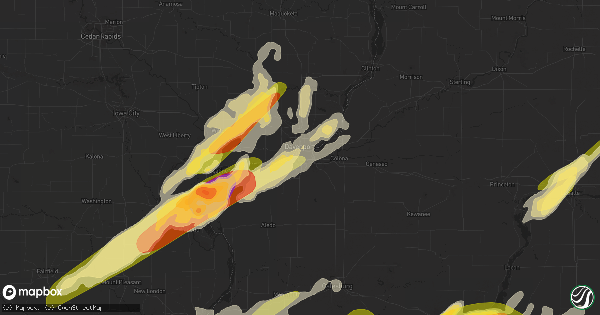
Hail Map in Rock Island, IL on March 15, 2016
Get this storm
March 15 map
$229
one time, instant access
Download today. No call, no setup
Keep the $229
Bought the map and want the full workflow? Apply the entire $229 to a subscription within 7 days. None of it is wasted.
Every map, not just this one
This buys you this map. Subscription and you get every map we run, in the markets you choose from a few cities to whole states to nationwide. Plus real-time alerts the moment a storm fires.
Contact data
Name, contact info, occupancy, even credit band for addresses in the footprint. You go from where it hit to who to call.
Become the source they trust
Unlimited branding weather history reports on demand. You already have the documented answer ready for the property owner, and you are the one who showed up with it.
Property data and RoofTrace estimates
Pull up any address you have got, its value and the exact code rules for that jurisdiction, straight from One Click Code. Then RoofTrace estimates the squares, pitch, and roof value, priced the way you price.
Storm reports in Rock Island, IL
Rock Island, IL
| Date | Description |
|---|---|
| 03/14/20167:11 PM CDT | Straight line wind damage track from il highway 92 and andalusia road through rock island...arsenal island into betterndorf. End time estimated around 725 pm by radar. |
All States Impacted by Hail Map on March 15, 2016
All Cities Impacted by Hail Map on March 15, 2016
- Ottawa, IL
- Lostant, IL
- Grand Ridge, IL
- Tonica, IL
- Utica, IL
- Wenona, IL
- Varna, IL
- Leonore, IL
- Washburn, IL
- La Rose, IL
- Oglesby, IL
- Magnolia, IL
- Toluca, IL
- Streator, IL
- Mount Morris, IL
- Stillman Valley, IL
- Polo, IL
- Amboy, IL
- Malden, IL
- Rockford, IL
- West Brooklyn, IL
- Oregon, IL
- Ohio, IL
- Leaf River, IL
- Steward, IL
- Paw Paw, IL
- Sublette, IL
- Princeton, IL
- Eldena, IL
- Lindenwood, IL
- Mendota, IL
- Harmon, IL
- Chana, IL
- Ashton, IL
- La Moille, IL
- Dixon, IL
- Holcomb, IL
- Rochelle, IL
- Davis Junction, IL
- Compton, IL
- Byron, IL
- Franklin Grove, IL
- Lee, IL
- Ladd, IL
- Earlville, IL
- Somonauk, IL
- Arlington, IL
- Sheridan, IL
- Serena, IL
- Hennepin, IL
- Peru, IL
- Granville, IL
- Dalzell, IL
- Standard, IL
- Spring Valley, IL
- Leland, IL
- La Salle, IL
- Mark, IL
- Morrison, IL
- Chadwick, IL
- Milledgeville, IL
- Ursa, IL
- Macomb, IL
- Keokuk, IA
- Lewistown, MO
- Saint Augustine, IL
- Colchester, IL
- Sciota, IL
- Carthage, IL
- Mendon, IL
- Sutter, IL
- La Belle, MO
- Saint Patrick, MO
- Williamstown, MO
- Warsaw, IL
- West Point, IL
- Avon, IL
- Roseville, IL
- Dallas City, IL
- Berwick, IL
- Maquon, IL
- Plymouth, IL
- La Harpe, IL
- Tennessee, IL
- Monticello, MO
- Elvaston, IL
- Gilson, IL
- Blandinsville, IL
- Good Hope, IL
- Basco, IL
- Prairie City, IL
- London Mills, IL
- Abingdon, IL
- Knox City, MO
- Hamilton, IL
- Kahoka, MO
- Alexandria, MO
- Canton, MO
- Joliet, IL
- Channahon, IL
- Carson City, MI
- Sheridan, MI
- Cabery, IL
- Emington, IL
- Bloomington, IL
- Williamsburg, IA
- Rensselaer, IN
- Kouts, IN
- San Pierre, IN
- Wheatfield, IN
- Marion, MI
- Sibley, IL
- Sheffield, IL
- Wilton, IA
- Durant, IA
- Lexington, IL
- Chestnut, IL
- Beason, IL
- Clinton, IL
- Farmington, IL
- Elmwood, IL
- Otterbein, IN
- Oxford, IN
- Templeton, IN
- Erie, IL
- Frankfort, IL
- Monee, IL
- Manhattan, IL
- Lincoln, IL
- Mount Pulaski, IL
- Kenney, IL
- Waynesville, IL
- Fairbury, IL
- Long Point, IL
- Ancona, IL
- Benson, IL
- Flanagan, IL
- Rutland, IL
- Dana, IL
- Minonk, IL
- Galena, IL
- Downs, IL
- Burlington, IA
- Shirley, IL
- Springfield, IL
- Danvers, IL
- Carlock, IL
- Secor, IL
- Congerville, IL
- El Paso, IL
- Goodfield, IL
- Roanoke, IL
- Eureka, IL
- Crawfordsville, IA
- Winfield, IA
- Columbus Junction, IA
- Olds, IA
- Mount Pleasant, IA
- Walcott, IA
- Dixon, IA
- Stockton, IA
- New Liberty, IA
- Martinsville, IL
- Casey, IL
- Marshall, IL
- Atalissa, IA
- Letts, IA
- Muscatine, IA
- Moscow, IA
- Carman, IL
- Gladstone, IL
- Stronghurst, IL
- Jacksonville, IL
- Franklin, IL
- Alexander, IL
- New Berlin, IL
- Winchester, IL
- Ashland, IL
- Blackstone, IL
- Ransom, IL
- Kinsman, IL
- Seneca, IL
- Verona, IL
- Galesburg, IL
- Murrayville, IL
- Pleasant Plains, IL
- Woodson, IL
- Beaverville, IL
- Lockridge, IA
- Fairfield, IA
- Mount Union, IA
- Fruitland, IA
- New Boston, IL
- Grandview, IA
- Illinois City, IL
- Wayland, IA
- Morning Sun, IA
- Wapello, IA
- Pleasant Valley, IA
- Le Claire, IA
- Bettendorf, IA
- Cameron, IL
- Monmouth, IL
- Annawan, IL
- Taylor Ridge, IL
- Pekin, IL
- Tremont, IL
- Wilmington, IL
- Marysville, IN
- Charlestown, IN
- Memphis, IN
- Sellersburg, IN
- Borden, IN
- Thawville, IL
- Dewitt, IL
- Le Roy, IL
- Bourbonnais, IL
- Roberts, IL
- Chatsworth, IL
- Kankakee, IL
- Saint Anne, IL
- Wapella, IL
- Bellflower, IL
- Martinton, IL
- Arrowsmith, IL
- Melvin, IL
- Ashkum, IL
- Anchor, IL
- Momence, IL
- Grant Park, IL
- Chebanse, IL
- Onarga, IL
- Cedar Lake, IN
- Strawn, IL
- Gilman, IL
- Clifton, IL
- Danforth, IL
- Beecher, IL
- Piper City, IL
- Saybrook, IL
- Farmer City, IL
- Gibson City, IL
- Donahue, IA
- Bennett, IA
- Bellevue, IA
- Calamus, IA
- Eldridge, IA
- Long Grove, IA
- Cullom, IL
- Brimfield, IL
- Hanna City, IL
- Hopedale, IL
- Towanda, IL
- Minier, IL
- Mackinaw, IL
- Stanford, IL
- Normal, IL
- Hudson, IL
- Chenoa, IL
- Gridley, IL
- Lowell, MI
- Geneseo, IL
- Ellisville, IL
- Fairview, IL
- Canton, IL
- Smithfield, IL
- Edwards, IL
- Peoria, IL
- Monticello, IN
- Cadillac, MI
- Ripley, TN
- Henning, TN
- New Washington, IN
- Floyds Knobs, IN
- Victoria, IL
- Williamsfield, IL
- East Peoria, IL
- Washington, IL
- Manito, IL
- Mapleton, IL
- Kingston Mines, IL
- Ladoga, IN
- Scales Mound, IL
- Reynolds, IL
- Joy, IL
- Smithshire, IL
- Media, IL
- Kirkwood, IL
- Biggsville, IL
- Lomax, IL
- Delmar, IA
- Charlotte, IA
- Lafayette, IN
- New Richmond, IN
- Westpoint, IN
- Romney, IN
- Mossville, IL
- Dunlap, IL
- Princeville, IL
- Peoria Heights, IL
- Chillicothe, IL
- Niota, IL
- Green Valley, IL
- Tiskilwa, IL
- Buda, IL
- Gardner, IL
- Tustin, MI
- Stanton, TN
- San Jose, IL
- Delavan, IL
- Sterling, IL
- Rock Falls, IL
- Sherman, IL
- Riverton, IL
- Williamsville, IL
- Blue Grass, IA
- Davenport, IA
- Andalusia, IL
- Buffalo, IA
- Milan, IL
- Wolcott, IN
- Rock Island, IL
- Maquoketa, IA
- Baldwin, IA
- Lost Nation, IA
- La Motte, IA
- Flora, IN
- Teutopolis, IL
- Sigel, IL
- Effingham, IL
- Luther, MI
- Lizton, IN
- Toledo, IL
- Easton, IL
- Bath, IL
- Mason City, IL
- Topeka, IL
- Emden, IL
- Havana, IL
- Kilbourne, IL
- Forest City, IL
- Roodhouse, IL
- Monon, IN
- Wayland, MO
- Nauvoo, IL
- Montrose, IA
- Raritan, IL
- Fort Madison, IA
- Wever, IA
- Argyle, IA
- Wyaconda, MO
- Marietta, IL
- Trivoli, IL
- Fulton, IL
- Forreston, IL
- Marseilles, IL
- De Witt, IA
- Adair, IL
- Bushnell, IL
- Wyoming, IL
- Russellville, IN
- Rockville, IN
- Greencastle, IN
- Augusta, IL
- Columbus City, IA
- Aledo, IL
- Hampton, IL
- Wheatland, IA
- Munford, TN
- Atoka, TN
- Drummonds, TN
- Bedford, KY
- Tipton, IA
- Lanark, IL
- Leroy, MI
- Covington, IN
- Westville, IL
- Perrysville, IN
- Catlin, IL
- Georgetown, IL
- Danville, IL
- Williamsport, IN
- Genoa, IL
- McBain, MI
- Colfax, IL
- Saint Johns, MI
- Dewitt, MI
- Braceville, IL
- Essex, IL
- Coopersville, MI
- Allendale, MI
- Bethlehem, IN
- Greenville, IN
- Carrollton, KY
- Campbellsburg, KY
- Metamora, IL
- Macy, IN
- Akron, IN
- Glasford, IL
- Creve Coeur, IL
- Liverpool, IL
- Lewistown, IL
- Morton, IL
- Livingston, WI
- Platteville, WI
- Lyndon, IL
- Roachdale, IN
- Carbon, IN
- Fairmount, IL
- Indianola, IL
- Elkhart, IL
- Cropsey, IL
- Lowell, IN
- Watseka, IL
- Forrest, IL
- Yates City, IL
- Atkinson, IL
- Shullsburg, WI
- Evart, MI
- Hillsdale, IL
- Cordova, IL
- Lake Village, IN
- Demotte, IN
- Mason, TN
- Covington, TN
- Ravenna, MI
- Bancroft, MI
- Tampico, IL
- Walnut, IL
- Brookston, IN
- Fowler, IN
- West Lafayette, IN
- Dennison, IL
- Westfield, IL
- Greenup, IL
- Clarence, IA
- Fair Oaks, IN
- Pembroke Township, IL
- Donovan, IL
- Idlewild, MI
- Durand, MI
- Corunna, MI
- Dwight, IL
- Cornell, IL
- Morris, IL
- Odell, IL
- Loraine, IL
- La Grange, MO
- Lowden, IA
- Cuba, IL
- Lowpoint, IL
- Edelstein, IL
- Norris, IL
- Elizabeth, IL
- Zwingle, IA
- Hanover, IL
- Savanna, IL
- Montrose, IL
- Wellston, MI
- Irons, MI
- Deer Creek, IL
- Cambridge, IL
- Grand Mound, IA
- Brighton, TN
- Athens, IL
- Cantrall, IL
- Petersburg, IL
- Kempton, IL
- Saunemin, IL
- Kirkland, IL
- Cherry Valley, IL
- Highland, WI
- Manteno, IL
- Peotone, IL
- Heyworth, IL
- Prophetstown, IL
- Crown Point, IN
- Galveston, IN
- Camden, IN
- Trufant, MI
- Hebron, IN
- Kewanee, IL
- Port Byron, IL
- East Moline, IL
- Birmingham, IA
- Moline, IL
- Conesville, IA
- Silvis, IL
- Coal Valley, IL
- Carbon Cliff, IL
- New Lothrop, MI
- Burchard, NE
- Seaton, IL
- Oquawka, IL
- Alpha, IL
- Woodhull, IL
- Ellsworth, IL
- Cooksville, IL
- Albany, IL
- Bitely, MI
- Maple Park, IL
- Hinckley, IL
- North Salem, IN
- Bradley, IL
- Clinton, IA
- McLean, IL
- Hurdland, MO
- Oxford, IA
- Bradford, IL
- Toulon, IL
- Bonfield, IL
- Hillview, IL
- Cutler, IN
- Bringhurst, IN
- Rossville, IN
- Delphi, IN
- South Pekin, IL
- Goose Lake, IA
- Attica, IN
- Montrose, MI
- Birch Run, MI
- Flushing, MI
- Fremont, MI
- White Cloud, MI
- Nunica, MI
- Saint John, IN
- Alexis, IL
- Gerlaw, IL
- Pontiac, IL
- Chrisman, IL
- Cayuga, IN
- Dana, IN
- Ridge Farm, IL
- Hersey, MI
- Sandwich, IL
- Dekalb, IL
- Edina, MO
- Knoxville, IL
- Montpelier, IA
- Stockport, IA
- Aroma Park, IL
- Bureau, IL
- Kingman, IN
- Tilton, IL
- Edgerton, WI


