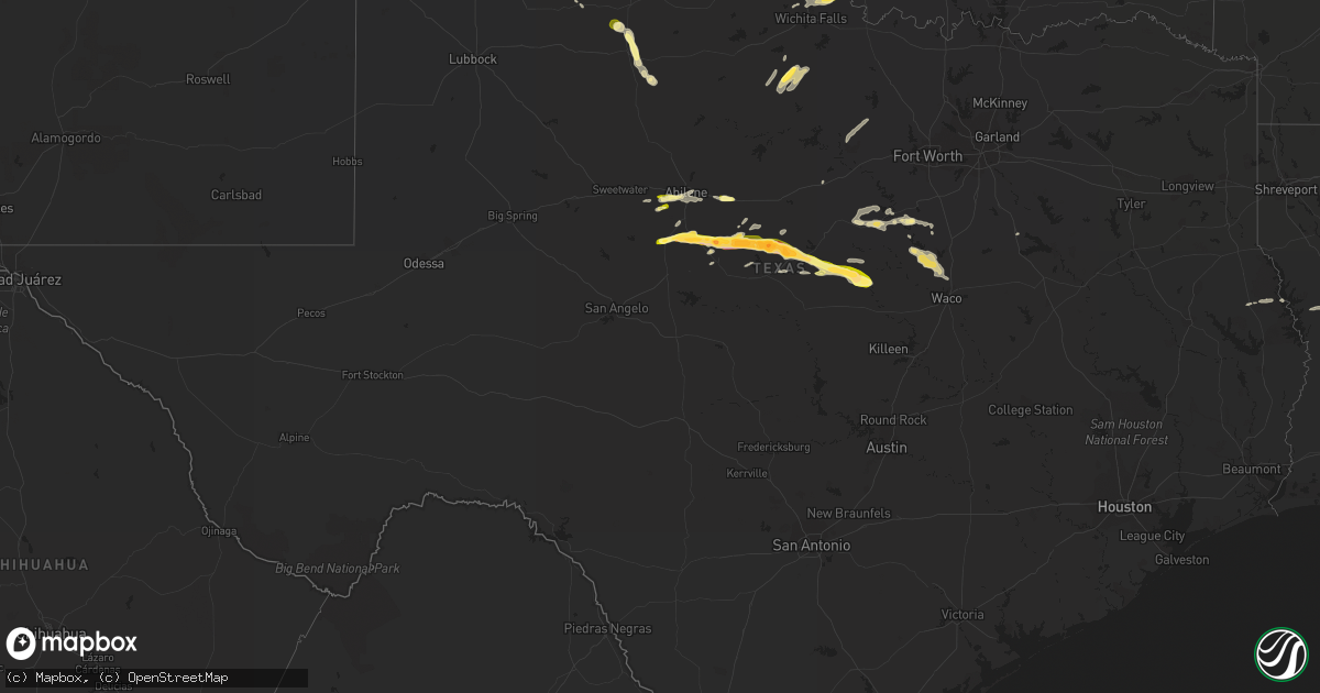
Hail Map in Texas on March 15, 2014
Get this storm
March 15 map
$229
one time, instant access
Download today. No call, no setup
Keep the $229
Bought the map and want the full workflow? Apply the entire $229 to a subscription within 7 days. None of it is wasted.
Every map, not just this one
This buys you this map. Subscription and you get every map we run, in the markets you choose from a few cities to whole states to nationwide. Plus real-time alerts the moment a storm fires.
Contact data
Name, contact info, occupancy, even credit band for addresses in the footprint. You go from where it hit to who to call.
Become the source they trust
Unlimited branding weather history reports on demand. You already have the documented answer ready for the property owner, and you are the one who showed up with it.
Property data and RoofTrace estimates
Pull up any address you have got, its value and the exact code rules for that jurisdiction, straight from One Click Code. Then RoofTrace estimates the squares, pitch, and roof value, priced the way you price.
Storm reports in Texas
Texas
| Date | Description |
|---|---|
| 03/15/20146:37 PM CDT | Quarter size hail in the city of commanche |
| 03/15/20146:20 PM CDT | A local report indicates 1.75 inch wind near SIDNEY |
| 03/15/20146:01 PM CDT | A local report indicates 2.00 inch wind near 1 E MAY |
| 03/15/20145:36 PM CDT | Golf ball hail covering highway 279. |
| 03/15/20145:30 PM CDT | Hail covering the ground on highway 206. |
| 03/15/20145:02 PM CDT | Hail covered interstate 20... With traffic slowing to 20 mph. Nickel to quarter size hail. Some car windshield cracked or broken. |
| 03/15/20144:58 PM CDT | Hail covering the ground. Most were penny size... But some were as large as golf balls. |
| 03/15/20144:33 PM CDT | A local report indicates 1.50 inch wind near GOLDSBORO |
| 03/15/20144:20 PM CDT | Spotter also reported a wall cloud 2 miles to the south. |
| 03/15/20144:07 PM CDT | A local report indicates 1.00 inch wind near 2 SW ABILENE |
| 03/15/20141:07 AM CDT | Quarter size hail falling on north side of lufkin |
| 03/14/201410:30 PM CDT | Midland international asos reported 60 mph wind gust from nearby thunderstorm |
| 03/14/20148:44 PM CDT | Roof collapsed trapping 1 person inside at 900 sw 3rd street. Person was not hurt. |
| 03/14/20148:40 PM CDT | Nickel size hail accompanied the storm as well. |
| 03/14/20147:46 PM CDT | Half dollar size hail 3 miles north of hamilton on county road 101 |
| 03/14/20147:25 PM CDT | Powerlines down at horseman and orr in lucas. |
| 03/14/20147:11 PM CDT | Fences blown down and some shingles blown off a roof in plano at the intersection of custer rd. And hedgecoxe rd. |
All States Impacted by Hail Map on March 15, 2014
Cities Impacted by Hail Map on March 15, 2014
- Paducah, TX
- Wichita, KS
- Ovalo, TX
- Tuscola, TX
- Florien, LA
- San Augustine, TX
- Rainbow, TX
- Nemo, TX
- Glen Rose, TX
- Cleburne, TX
- Granbury, TX
- Comanche, TX
- Goldsboro, TX
- May, TX
- Blanket, TX
- Sidney, TX
- Burkett, TX
- Dublin, TX
- Cross Plains, TX
- Brownwood, TX
- Gustine, TX
- Hamilton, TX
- Winters, TX
- Novice, TX
- Hico, TX
- Coleman, TX
- Lawn, TX
- Rising Star, TX
- Clyde, TX
- Carlton, TX
- Jonesboro, TX
- Olney, TX
- Windthorst, TX
- Holliday, TX
- Baird, TX
- Rio Vista, TX
- Blum, TX
- Old Glory, TX
- Manchester, OK
- Peck, KS
- Poolville, TX
- Graford, TX
- Whitt, TX
- Perrin, TX
- Mineral Wells, TX
- Newcastle, TX
- Clearwater, KS
- Elk City, KS
- Neodesha, KS
- Zephyr, TX
- Aquilla, TX
- Elm Mott, TX
- Meridian, TX
- Whitney, TX
- Morgan, TX
- Waco, TX
- Clifton, TX
- West, TX
- Kopperl, TX
- Merkel, TX
- Stephenville, TX
- Purvis, MS
- Waurika, OK
- Ryan, OK
- Byers, TX
- Wichita Falls, TX
- Petrolia, TX
- Temple, OK
- Abilene, TX
- Tye, TX
- Walnut Springs, TX
- Milam, TX
- Leon, KS
- Haysville, KS
- Mingus, TX
- Burkburnett, TX
- Sheppard Afb, TX
- Conway Springs, KS
- Dyess Afb, TX
- De Leon, TX
- Matador, TX
- Ratliff City, OK
- Bluff Dale, TX
- Hattiesburg, MS
- Eastland, TX
- Breckenridge, TX
- Ranger, TX
- Independence, KS
- Havana, KS
- Covington, TX
- Grandview, TX
- Tolar, TX
- Iowa Park, TX
- Amorita, OK
- Loco, OK
- Duncan, OK
- Milton, KS
- Hillsboro, TX
- Corsicana, TX
- Douglass, KS
- Atlanta, KS


