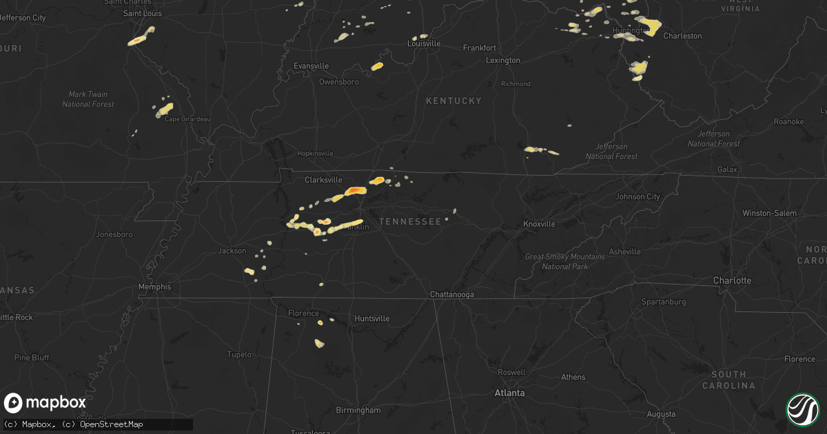
Hail Map in Tennessee on March 14, 2012
Get this storm
March 14 map
$229
one time, instant access
Download today. No call, no setup
Keep the $229
Bought the map and want the full workflow? Apply the entire $229 to a subscription within 7 days. None of it is wasted.
Every map, not just this one
This buys you this map. Subscription and you get every map we run, in the markets you choose from a few cities to whole states to nationwide. Plus real-time alerts the moment a storm fires.
Contact data
Name, contact info, occupancy, even credit band for addresses in the footprint. You go from where it hit to who to call.
Become the source they trust
Unlimited branding weather history reports on demand. You already have the documented answer ready for the property owner, and you are the one who showed up with it.
Property data and RoofTrace estimates
Pull up any address you have got, its value and the exact code rules for that jurisdiction, straight from One Click Code. Then RoofTrace estimates the squares, pitch, and roof value, priced the way you price.
Storm reports in Tennessee
Tennessee
| Date | Description |
|---|---|
| 03/14/20126:54 PM CDT | Hail reported on 109 south of portland. Damage to several vehicles. |
| 03/14/20126:41 PM CDT | A local report indicates 1.75 inch wind near GREENBRIER |
| 03/14/20126:41 PM CDT | A local report indicates 1.00 inch wind near 1 N GOODLETTSVILLE |
| 03/14/20126:36 PM CDT | A local report indicates 1.00 inch wind near MILLERSVILLE |
| 03/14/20126:36 PM CDT | A local report indicates 2.00 inch wind near 3 WSW GREENBRIER |
| 03/14/20126:35 PM CDT | A local report indicates 1.00 inch wind near 1 SW GREENBRIER |
| 03/14/20126:32 PM CDT | A local report indicates 1.00 inch wind near GREENBRIER |
| 03/14/20126:29 PM CDT | Hail reported in antioch near nolensville pike |
| 03/14/20126:29 PM CDT | A local report indicates 1.00 inch wind near 4 W GREENBRIER |
| 03/14/20126:28 PM CDT | Hail reported in coopertown |
| 03/14/20126:18 PM CDT | A local report indicates 1.00 inch wind near 1 NE FRANKLIN |
| 03/14/20126:15 PM CDT | A local report indicates 1.25 inch wind near BRENTWOOD |
| 03/14/20126:15 PM CDT | A local report indicates 1.00 inch wind near 2 N ASHLAND CITY |
| 03/14/20126:02 PM CDT | A local report indicates 1.50 inch wind near FRANKLIN |
| 03/14/20126:00 PM CDT | A local report indicates 1.50 inch wind near 4 SSE PORTLAND |
| 03/14/20126:00 PM CDT | A local report indicates 1.00 inch wind near CHARLOTTE |
| 03/14/20125:45 PM CDT | A local report indicates 1.75 inch wind near GREENBRIER |
| 03/14/20125:25 PM CDT | Public report relayed from nancy vancamp at wsmv. |
| 03/14/20125:25 PM CDT | A local report indicates 1.00 inch wind near FAIRVIEW |
| 03/14/20124:50 PM CDT | Hail reported in nunnelly |
| 03/14/20124:30 PM CDT | Hail reported in leoma |
| 03/14/20124:28 PM CDT | A local report indicates 1.25 inch wind near 10 S MCEWEN |
| 03/14/20124:20 PM CDT | A local report indicates 1.00 inch wind near LORETTO |
| 03/14/20124:17 PM CDT | A local report indicates 1.75 inch wind near 6 S WAVERLY |
| 03/14/20123:35 PM CDT | Pea to quarter size hail reported on hwy 22 1 mile from the intersection with hwy 64 near adamsville. |
| 03/14/20122:38 PM CDT | Ping pong ball size hail was reported 4 ene of finger in mcnairy county. |
| 03/14/20121:50 AM CDT | A local report indicates 1.00 inch wind near MONTEREY |
| 03/13/20127:43 PM CDT | A local report indicates 1.00 inch wind near LAFAYETTE |
| 03/13/20127:32 PM CDT | A local report indicates 1.00 inch wind near 1 W WESTMORELAND |
| 03/13/20127:10 PM CDT | A local report indicates 1.00 inch wind near 2 N GALLATIN |
All States Impacted by Hail Map on March 14, 2012
Cities Impacted by Hail Map on March 14, 2012
- Columbia, IL
- Mount Cory, OH
- Bluffton, OH
- Rawson, OH
- Bellevue, OH
- Monroeville, OH
- Alexandria, OH
- Newark, OH
- Granville, OH
- Johnstown, OH
- Huntingburg, IN
- Velpen, IN
- Stendal, IN
- Wellington, OH
- Hawthorne, FL
- Bellville, OH
- Butler, OH
- Fredericktown, OH
- Haviland, OH
- Lenore, WV
- Lovely, KY
- Williamson, WV
- Goodlettsville, TN
- Joelton, TN
- Ashland City, TN
- Springfield, TN
- Greenbrier, TN
- Pleasant View, TN
- Woodville, OH
- Perrysburg, OH
- Pemberville, OH
- Genoa, OH
- Luckey, OH
- Cutler, IN
- Kalamazoo, MI
- Waverly, TN
- Evergreen, AL
- Gallatin, TN
- Bethpage, TN
- Portland, TN
- Cottontown, TN
- Tallahassee, FL
- Huron, OH
- Mount Vernon, OH
- Ona, WV
- Glenwood, WV
- Milton, WV
- Hurricane, WV
- Lesage, WV
- Culloden, WV
- Londonderry, OH
- Chillicothe, OH
- Arjay, KY
- Flat Lick, KY
- Walker, KY
- Stout, OH
- Vanceburg, KY
- Centerville, TN
- Cumberland Furnace, TN
- Vanleer, TN
- Dickson, TN
- Town Creek, AL
- Mount Olive, IL
- Walshville, IL
- Staunton, IL
- Litchfield, IL
- Ney, OH
- Defiance, OH
- Canal Winchester, OH
- Baltimore, OH
- Carroll, OH
- Pickerington, OH
- Medora, IN
- Lawrenceville, IL
- Bridgeport, IL
- Jasper, IN
- Bryan, OH
- Evansport, OH
- Stryker, OH
- Archbold, OH
- Napoleon, OH
- Sherwood, OH
- Wauseon, OH
- New London, OH
- Nova, OH
- Sullivan, OH
- Laurelville, OH
- South Bloomingville, OH
- Circleville, OH
- Adelphi, OH
- McArthur, OH
- Kingston, OH
- Petersburg, MI
- Ida, MI
- Pevely, MO
- Waterloo, IL
- Valmeyer, IL
- Herculaneum, MO
- Festus, MO
- McEwen, TN
- Thomasville, GA
- Pierceton, IN
- Findlay, OH
- Bethel Springs, TN
- Adamsville, TN
- Finger, TN
- Burns, TN
- Bon Aqua, TN
- Lafayette, TN
- Only, TN
- Hurricane Mills, TN
- Nunnelly, TN
- Quitman, GA
- Duck River, TN
- Lyles, TN
- Jackson, MO
- Patton, MO
- Oak Ridge, MO
- Burfordville, MO
- Marble Hill, MO
- Glenallen, MO
- Millersville, MO
- Franklin, TN
- Brentwood, TN
- Huron, TN
- Reagan, TN
- Lexington, TN
- Greenville, MO
- Starkville, MS
- West Point, MS
- Charlotte, TN
- Chapmansboro, TN
- Dingess, WV
- Fort Gay, WV
- Kermit, WV
- Harts, WV
- Dunlow, WV
- Wilsondale, WV
- Crum, WV
- Breeden, WV
- Winfield, WV
- Dola, OH
- Ada, OH
- Milan, OH
- Berlin Heights, OH
- Vermilion, OH
- Kiahsville, WV
- Millersport, OH
- Pataskala, OH
- Hebron, OH
- Kirkersville, OH
- Ashland, OH
- Perrysville, OH
- Waverly, OH
- Gordon, AL
- Millstadt, IL
- Kenova, WV
- Catlettsburg, KY
- Old Town, FL
- Sylvester, GA
- Albany, GA
- Paw Paw, MI
- Doerun, GA
- Newton, GA
- Bainbridge, OH
- Hillsboro, OH
- Argillite, KY
- Hastings, MI
- Middleville, MI
- Primm Springs, TN
- Oak Harbor, OH
- Lindsey, OH
- Fremont, OH
- Monterey, TN
- Sizerock, KY
- Hyden, KY
- Thousandsticks, KY
- West Portsmouth, OH
- Otway, OH
- Columbia City, IN
- Union Star, KY
- Stephensport, KY
- Rhodelia, KY
- Cannelton, IN
- Rome, IN
- Payneville, KY
- Greenwich, OH
- Crawford, MS
- Brooksville, MS
- Garrison, KY
- Jeffersonville, IN
- Lamont, FL
- Summerville, SC
- Maumee, OH
- Gray, KY
- Barbourville, KY
- Heidrick, KY
- Salt Rock, WV
- Crown City, OH
- Scottown, OH
- West Hamlin, WV
- Fraziers Bottom, WV
- Barboursville, WV
- South Shore, KY
- Quincy, KY
- South Portsmouth, KY
- Sardis, TN
- Saltillo, TN
- Jacksonville, FL
- Middleburg, FL
- Mansfield, OH
- Sellersburg, IN
- Clarksville, IN
- New Albany, IN
- Tifton, GA
- Ashburn, GA
- Corbin, KY
- Woodbine, KY
- Mount Hope, AL
- Moulton, AL
- Derby, IN
- Hardinsburg, KY
- Marshall, MI
- Homer, MI
- Ranger, WV
- Orleans, IN
- Mitchell, IN
- Elmore, OH
- Croton, OH
- Centerburg, OH
- Hendersonville, TN
- Perryville, MO
- Friedheim, MO
- Gainesville, FL
- Huntington, IN
- Parsons, TN
- Darden, TN
- Rensselaer, IN
- Pilgrim, KY
- Inez, KY
- Archer, FL
- Hartsville, TN
- Jakin, GA
- Norwalk, OH
- Macclenny, FL
- Jackson, OH
- Floyds Knobs, IN
- Georgetown, IN
- Hillsboro, AL
- Coldwater, MI
- Chiefland, FL
- Warfield, KY
- Carleton, MI
- Monroe, MI
- Huntington, WV
- Loretto, TN
- Leoma, TN
- Lawrenceburg, TN
- Venedocia, OH
- Delphos, OH
- Sumner, GA
- Poulan, GA
- Portage, OH
- Rudolph, OH
- White House, TN
- Benld, IL
- Oak Hill, OH
- Waterloo, OH
- Gallipolis, OH
- Patriot, OH
- Warsaw, IN
- Winona Lake, IN
- Schoolcraft, MI
- Loogootee, IN
- Kitts Hill, OH
- Pedro, OH
- New Albany, OH
- Utica, OH
- Wakeman, OH
- Olive Hill, KY
- Lavalette, WV
- Thornville, OH
- Buckeye Lake, OH
- Columbus, OH
- Fairview, TN
- Sedgewickville, MO
- Continental, OH
- French Lick, IN
- Paoli, IN
- Markle, IN
- Roanoke, IN
- Yoder, IN
- Lucas, OH
- Sparta, TN
- Lancaster, OH
- Cannon, KY
- Columbus Grove, OH
- Ottawa, OH
- Shelby, OH
- Three Rivers, MI
- Crystal City, MO
- Hillsboro, MO
- Wheelersburg, OH
- Franklin Furnace, OH
- Hohenwald, TN
- Trenton, FL
- Camilla, GA
- Newberry, FL
- Headland, AL
- Newville, AL
- Mississippi State, MS
- Sawyerville, IL
- Willow Wood, OH
- Crothersville, IN
- Paris Crossing, IN
- Claremont, IL
- Calhoun, IL
- Fort Jennings, OH
- Bolivia, NC
- Winnabow, NC
- Wallingford, KY
- Mount Gilead, OH
- Emerson, KY
- Tuscumbia, AL
- Piketon, OH
- Van Wert, OH
- Grayson, KY
- Paulding, OH
- Polk, OH
- Mount Victory, OH
- Portage, MI
- White Pigeon, MI
- Bronson, MI
- Decatur, IN
- Burr Oak, MI
- Centreville, MI
- Colon, MI
- Sturgis, MI
- Salem, IN
- Rockholds, KY
- Montgomery, IN
- Galion, OH
- Arlington, OH
- Forest, OH
- Morven, GA
- Decatur, MI
- Dowagiac, MI
- Grover Hill, OH
- Oakwood, OH
- Cloverdale, OH
- Wayne, WV
- Rush, KY
- Prichard, WV
- Branchland, WV
- Bunker Hill, IL
- Austin, IN
- Marquand, MO
- Proctorville, OH
- Ray, OH
- Wellston, OH
- Chagrin Falls, OH
- Novelty, OH
- Chula, GA
- Chesapeake, OH
- Greenup, KY
- Shoals, IN
- Bimble, KY
- Hinkle, KY
- Convoy, OH
- Lawton, MI
- Marcellus, MI
- Castalian Springs, TN
- Maybee, MI
- Brownstown, IN
- Niles, MI
- Westmoreland, TN
- Marengo, OH
- Campbellsburg, IN
- Blue Creek, OH
- Otwell, IN
- Sumner, IL
- Dubois, IN
- Scotts Hill, TN
- Buchanan, MI
- Gillespie, IL
- Pleasantville, OH
- Adolphus, KY
- Gibsonburg, OH
- Ossian, IN
- Vallonia, IN
- Delton, MI


