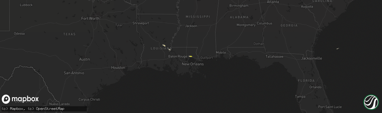
Hail Map on March 11, 2018
The weather event on March 11, 2018 includes Hail map. 1 state and 8 cities were impacted and suffered possible damage. The total estimated number of properties impacted is 4,798.
Want more than just the map?
Turn this storm into a full workflow.
- Owner + property data so you know who to knock
- OnDemand branded weather history reports to win the "did we even have hail?" argument
- RoofTrace estimate so reps stop guessing numbers at the door
Bought this map? Upgrade within 7 days and we'll credit the $230. (10-15 min setup call)
Hail
4,798
Estimated number of impacted properties by a 1.00" hail or larger0
Estimated number of impacted properties by a 1.75" hail or larger0
Estimated number of impacted properties by a 2.50" hail or largerStates Impacted by Hail Map on March 11, 2018
Storm reports
Arkansas
| Date | Description |
|---|---|
| 03/11/20187:44 AM CDT | At 1244 AM CST, a severe thunderstorm was located over Lanark, or 11 miles east of Hampton, moving southeast at 25 mph. HAZARD...60 mph wind gusts and quarter size hail. SOURCE...Radar indicated. IMPACT...Hail damage to vehicles is expected. Expect wind damage to roofs, siding, and trees. Locations impacted include... Hermitage... Lanark... Banks... Carmel... Farmville... Gravelridge... |
| 03/11/20187:26 AM CDT | At 1225 AM CST, a severe thunderstorm was located over Old Milo, or 8 miles north of North Crossett, moving east at 25 mph. HAZARD...Ping pong ball size hail and 60 mph wind gusts. SOURCE...Radar indicated. IMPACT...People and animals outdoors will be injured. Expect hail damage to roofs, siding, windows, and vehicles. Expect wind damage to roofs, siding, and trees. This severe thunderstorm will be near... Fountain Hill and Old Milo around 1230 AM CST. Hamburg around 1245 AM CST. Snyder around 105 AM CST. Portland around 120 AM CST. Parkdale around 125 AM CST. |
| 03/10/20187:27 PM CST | At 127 AM CST, a severe thunderstorm was located over Wilmot, moving southeast at 35 mph. HAZARD...Golf ball size hail and 60 mph wind gusts. SOURCE...Radar indicated. IMPACT...People and animals outdoors will be injured. Expect hail damage to roofs, siding, windows, and vehicles. Expect wind damage to roofs, siding, and trees. This severe thunderstorm will be near... Millikin and Gassoway around 300 AM CDT. Shelburn around 305 AM CDT. Lake Providence around 315 AM CDT. Other locations impacted by this severe thunderstorm includeMayersville and Kilbourne. |
| 03/10/20187:01 PM CST | At 101 AM CST, a severe thunderstorm was located over Eudora, moving southeast at 30 mph. HAZARD...60 mph wind gusts and quarter size hail. SOURCE...Radar indicated. IMPACT...Hail damage to vehicles is expected. Expect wind damage to roofs, siding, and trees. This severe thunderstorm will be near... Glen Allan around 130 AM CST. Grace around 140 AM CST. |
Alabama
| Date | Description |
|---|---|
| 03/10/201810:07 PM CST | At 406 AM CDT, severe thunderstorms were located along a line extending from near Little Rock to near Decatur to near Newton, moving southeast at 40 mph. HAZARD...60 mph wind gusts. SOURCE...Radar indicated. IMPACT...Expect damage to roofs, siding, and trees. Severe thunderstorms will be near... Duffee around 415 AM CDT. Suqualena around 420 AM CDT. Meehan around 425 AM CDT. Meridian and Nellieburg around 430 AM CDT. Marion and Savoy around 435 AM CDT. Zero around 440 AM CDT. Stonewall around 445 AM CDT. Increase, Sable and Toomsuba around 450 AM CDT. Other locations impacted by these severe thunderstorms include Chunkyand Hickory. |
Mississippi
| Date | Description |
|---|---|
| 03/11/20182:37 PM CDT | .yazoo county/bentonia tornado... Rating: ef1 estimated peak wind: 90 mph path length /statute/: 1.5 miles path width /maximum/: 200 yards fatalities: 0 injuries: 0 sta |
| 03/11/201812:05 PM CDT | Quarter size hail reported across pickens. |
| 03/11/20187:51 AM CDT | At 1251 AM CST, a severe thunderstorm was located near Coxburg, or 10 miles northeast of Yazoo City, moving southeast at 30 mph. HAZARD...60 mph wind gusts. SOURCE...Radar indicated. IMPACT...Expect damage to roofs, siding, and trees. This severe thunderstorm will be near... Benton around 1255 AM CST. Pickens and Vaughan around 120 AM CST. Way around 125 AM CST. Cameron around 130 AM CST. Camden and Sharon around 140 AM CST. Farmhaven around 150 AM CST. |
| 03/11/20187:13 AM CDT | At 1213 AM CST, a severe thunderstorm was located over Delta City, or 9 miles southeast of Hollandale, moving southeast at 30 mph. HAZARD...Golf ball size hail and 60 mph wind gusts. SOURCE...Radar indicated. IMPACT...People and animals outdoors will be injured. Expect hail damage to roofs, siding, windows, and vehicles. Expect wind damage to roofs, siding, and trees. This severe thunderstorm will be near... Midnight around 1235 AM CST. Yazoo City around 105 AM CST. Other locations impacted by this severe thunderstorm include Eden andLouise. |
| 03/11/20187:11 AM CDT | At 1211 AM CST, a severe thunderstorm was located over Ebenezer, or 15 miles southeast of Thornton, moving southeast at 30 mph. HAZARD...Golf ball size hail and 60 mph wind gusts. SOURCE...Radar indicated. IMPACT...People and animals outdoors will be injured. Expect hail damage to roofs, siding, windows, and vehicles. Expect wind damage to roofs, siding, and trees. This severe thunderstorm will be near... Goodman and Pickens around 1230 AM CST. Cameron around 1240 AM CST. Camden and Newport around 1250 AM CST. |
| 03/11/20187:02 AM CDT | At 1202 AM CST, a severe thunderstorm was located over Pickens, or 16 miles south of Durant, moving east at 25 mph. HAZARD...60 mph wind gusts and quarter size hail. SOURCE...Radar indicated. IMPACT...Hail damage to vehicles is expected. Expect wind damage to roofs, siding, and trees. This severe thunderstorm will be near... Cameron around 1210 AM CST. Camden around 1220 AM CST. Thomastown around 1240 AM CST. Carthage around 1255 AM CST. Singleton around 100 AM CST. Other locations impacted by this severe thunderstorm includeRedwater. |
| 03/10/201810:06 PM CST | At 405 AM CDT, a severe thunderstorm was located near Burns, or 12 miles south of Forest, moving southeast at 40 mph. HAZARD...60 mph wind gusts. SOURCE...Radar indicated. IMPACT...Expect damage to roofs, siding, and trees. This severe thunderstorm will be near... Pineville around 420 AM CDT. Bay Springs around 435 AM CDT. Turnerville around 440 AM CDT. Vernon around 450 AM CDT. Other locations impacted by this severe thunderstorm includeSylvarena, Montrose and Louin. |
| 03/10/20189:08 PM CST | At 308 AM CDT, a severe thunderstorm was located over Gluckstadt, or near Canton, moving southeast at 40 mph. HAZARD...Golf ball size hail and 70 mph wind gusts. SOURCE...Radar indicated. IMPACT...People and animals outdoors will be injured. Expect hail damage to roofs, siding, windows, and vehicles. Expect considerable tree damage. Wind damage is also likely to mobile homes, roofs, and outbuildings. This severe thunderstorm will be near... Goshen Springs around 320 AM CDT. Fannin and Pisgah around 325 AM CDT. Leesburg around 335 AM CDT. Pelahatchie and Branch around 340 AM CDT. Morton around 345 AM CDT. Pulaski around 355 AM CDT. Homewood around 405 AM CDT. Other locations impacted by this severe thunderstorm includePolkville. |
| 03/10/20187:49 PM CST | At 149 AM CST, a severe thunderstorm was located over Farmhaven, or 15 miles southwest of Carthage, moving southeast at 40 mph. HAZARD...Ping pong ball size hail and 60 mph wind gusts. SOURCE...Radar indicated. IMPACT...People and animals outdoors will be injured. Expect hail damage to roofs, siding, windows, and vehicles. Expect wind damage to roofs, siding, and trees. This severe thunderstorm will be near... Ludlow around 300 AM CDT. Tuscola around 310 AM CDT. Harperville and Hillsboro around 320 AM CDT. Steele around 325 AM CDT. Other locations impacted by this severe thunderstorm include Lena,Walnut Grove and Sebastopol. |
| 03/10/20187:25 PM CST | At 125 AM CST, a severe thunderstorm was located over Tinsley, or near Yazoo City, moving southeast at 35 mph. HAZARD...Golf ball size hail and 60 mph wind gusts. SOURCE...Radar indicated. IMPACT...People and animals outdoors will be injured. Expect hail damage to roofs, siding, windows, and vehicles. Expect wind damage to roofs, siding, and trees. This severe thunderstorm will be near... Little Yazoo around 135 AM CST. Myrleville around 145 AM CST. Canton and Gluckstadt around 310 AM CDT. Sharon around 315 AM CDT. Other locations impacted by this severe thunderstorm include Satartiaand Bentonia. |
Texas
| Date | Description |
|---|---|
| 03/10/201810:40 PM CST | At 440 AM CDT, severe thunderstorms were located along a line extending from near Scroggins to near Emory, moving southeast at 25 mph. HAZARD...60 mph wind gusts and quarter size hail. SOURCE...Radar indicated. IMPACT...Hail damage to vehicles is expected. Expect wind damage to roofs, siding, and trees. Locations impacted include... Gilmer, Mineola, Winnsboro, Leesburg, Quitman, Rosewood, Scroggins, Pleasant Grove, Newsome, Hainesville, Golden, Forest Hill, Alba, Yantis, Midway, Perryville, Bettie and Grice. |
| 03/10/201810:05 PM CST | At 404 AM CDT, a severe thunderstorm was located near Cumby, or 9 miles south of Commerce, moving southeast at 35 mph. HAZARD...60 mph wind gusts and quarter size hail. SOURCE...Radar indicated. IMPACT...Hail damage to vehicles is expected. Expect wind damage to roofs, siding, and trees. Locations impacted include... Sulphur Springs, Commerce, Emory, Cumby, Como, Campbell, Point, Lone Oak and Neylandville.This includes Interstate 30 between mile markers 90 and 134. |
| 03/10/201810:04 PM CST | At 404 AM CDT, a severe thunderstorm was located over Longview, moving southeast at 35 mph. HAZARD...70 mph wind gusts and half dollar size hail. SOURCE...Radar indicated. IMPACT...Hail damage to vehicles is expected. Expect considerable tree damage. Wind damage is also likely to mobile homes, roofs, and outbuildings. Locations impacted include... Longview, Kilgore, Hallsville, Tatum, Beckville, Lakeport, Easton, Rolling Meadows, Chalk Hill, Darco, Judson and Stewart. |
| 03/10/20189:33 PM CST | At 333 AM CDT, a severe thunderstorm was located near Gilmer, moving east at 35 mph. HAZARD...70 mph wind gusts and quarter size hail. SOURCE...Radar indicated. IMPACT...Hail damage to vehicles is expected. Expect considerable tree damage. Wind damage is also likely to mobile homes, roofs, and outbuildings. Locations impacted include... Longview, White Oak, Gladewater, Gilmer, Clarksville City, East Mountain, Diana, Rosewood, West Mountain, Union Grove, Warren City, Pritchett and Judson. |
| 03/10/20189:16 PM CST | At 316 AM CDT, a severe thunderstorm was located over Diana, or 10 miles east of Gilmer, moving southeast at 20 mph. HAZARD...70 mph wind gusts and half dollar size hail. SOURCE...Radar indicated. IMPACT...Hail damage to vehicles is expected. Expect considerable tree damage. Wind damage is also likely to mobile homes, roofs, and outbuildings. Locations impacted include... Longview, Hallsville, Diana, Harleton, Nesbitt and Judson. |
| 03/10/20187:12 PM CST | At 112 AM CST, a severe thunderstorm was located near Elysian Fields, or 19 miles northeast of Carthage, moving southeast at 35 mph. HAZARD...70 mph wind gusts and half dollar size hail. SOURCE...Radar indicated. IMPACT...Hail damage to vehicles is expected. Expect considerable tree damage. Wind damage is also likely to mobile homes, roofs, and outbuildings. Locations impacted include... Deberry, Elysian Fields, Keachi, Longstreet, Keat Chie, Midyett, Kickapoo, Front and Spring Ridge. |
Louisiana
| Date | Description |
|---|---|
| 03/11/201812:06 PM CDT | Fence downed on veronica drive in chalmette. |
| 03/11/201811:46 AM CDT | A local report indicates 64 MPH wind near LAKEFRONT AIRPORT |
| 03/11/201811:25 AM CDT | Large tree down across highway 190 near soult street. |
| 03/11/201811:20 AM CDT | 60 mph winds and two waterspouts reported by lake pontchartrain causeway officials. |
| 03/11/201811:12 AM CDT | A local report indicates 1.00 inch wind near MADISONVILLE |
| 03/11/20188:10 AM CDT | Fire dept reported damage to house with injuries. |
| 03/11/20188:10 AM CDT | *** 4 inj *** tornado hit double wide trailer and rolled it. Family of 4 sustained minor injuries. |
| 03/11/20187:39 AM CDT | Received image of large tree blown down. |
| 03/11/20187:21 AM CDT | At 1220 AM CST, a severe thunderstorm was located near Woodlawn, or 8 miles northwest of Marshall, moving southeast at 35 mph. HAZARD...Two inch hail and 60 mph wind gusts. SOURCE...Radar indicated. IMPACT...People and animals outdoors will be injured. Expect hail damage to roofs, siding, windows, and vehicles. Expect wind damage to roofs, siding, and trees. Locations impacted include... Marshall, Deberry, Elysian Fields, Woodlawn, Scottsville, Nesbitt and Darco. |
| 03/11/20186:55 AM CDT | At 1155 AM CDT, a severe thunderstorm was located over Chalmette, moving southeast at 35 mph. HAZARD...60 mph wind gusts. SOURCE...Radar indicated. IMPACT...Expect damage to roofs, siding, and trees. Locations impacted include... New Orleans, Chalmette, Violet, Meraux, Shell Beach, Arabi and Poydras.65 mph gust measured at Lakefront Airport. |
| 03/11/20186:37 AM CDT | At 1137 AM CDT, a severe thunderstorm was located near St. Rose, or 7 miles west of Metairie, moving southeast at 35 mph. HAZARD...60 mph wind gusts. SOURCE...Radar indicated. IMPACT...Expect damage to roofs, siding, and trees. Locations impacted include... Metairie, Avondale, Jefferson, Harahan, Westwego, Elmwood, Bridge City, River Ridge, Ama, Waggaman, St. Rose, Luling, Destrehan and New Orleans Armstrong Airport. |
| 03/11/20186:34 AM CDT | At 1133 AM CDT, a severe thunderstorm was located near East New Orleans, moving southeast at 30 mph. HAZARD...60 mph wind gusts. SOURCE...Radar indicated. IMPACT...Expect damage to roofs, siding, and trees. Locations impacted include... New Orleans, East New Orleans, Chalmette, Arabi and Lakefront Airport. |
| 03/11/20185:59 AM CDT | At 1059 AM CDT, a severe thunderstorm was located near Madisonville, or near Covington, moving east at 30 mph. HAZARD...60 mph wind gusts and quarter size hail. SOURCE...Radar indicated. IMPACT...Hail damage to vehicles is expected. Expect wind damage to roofs, siding, and trees. Locations impacted include... Covington, Abita Springs and Madisonville. |
| 03/11/20184:57 AM CDT | At 957 AM CDT, a severe thunderstorm was located near Baker, moving southeast at 35 mph. HAZARD...60 mph wind gusts. SOURCE...Radar indicated. IMPACT...Expect damage to roofs, siding, and trees. Locations impacted include... Baton Rouge, Zachary, Baker, Denham Springs, Port Allen, Oak Hills Place, Westminster, Old Jefferson, Merrydale, Inniswold, Village St. George, Shenandoah, Brownfields, Greenwell Spring, Gardere and Baton Rouge Airport. |
| 03/11/20184:07 AM CDT | At 907 AM CDT, a severe thunderstorm was located over Batchelor, or 7 miles east of Bayou Current, moving southeast at 30 mph. HAZARD...60 mph wind gusts and penny size hail. SOURCE...Radar indicated. IMPACT...Expect damage to roofs, siding, and trees. Locations impacted include... New Roads, St. Francisville, Livonia, Fordoche, Morganza, Wakefield, Batchelor and Lottie. |
| 03/10/201810:48 PM CST | At 448 AM CDT, a severe thunderstorm was located 7 miles west of Deberry, or 9 miles north of Carthage, moving southeast at 30 mph. HAZARD...60 mph wind gusts and quarter size hail. SOURCE...Radar indicated. IMPACT...Hail damage to vehicles is expected. Expect wind damage to roofs, siding, and trees. Locations impacted include... Carthage, Tatum, Beckville, Deberry, Gary City, Midyett, Deadwood, Dotson, Front, Woods and Fairplay. |
| 03/10/201810:23 PM CST | At 423 AM CDT, a severe thunderstorm was located 8 miles north of Coushatta, or 24 miles east of Mansfield, moving east at 30 mph. HAZARD...60 mph wind gusts and quarter size hail. SOURCE...Radar indicated. IMPACT...Hail damage to vehicles is expected. Expect wind damage to roofs, siding, and trees. Locations impacted include... Coushatta, Martin, Goldonna, Hall Summit, Saline, Ashland, Edgefield, Womack, Chestnut, Creston and Black Lake. |
| 03/10/201810:21 PM CST | At 421 AM CDT, a severe thunderstorm was located near Marshall, moving southeast at 30 mph. HAZARD...70 mph wind gusts and half dollar size hail. SOURCE...Radar indicated. IMPACT...Hail damage to vehicles is expected. Expect considerable tree damage. Wind damage is also likely to mobile homes, roofs, and outbuildings. Locations impacted include... Marshall, Waskom, Deberry, Elysian Fields, Scottsville, Darco, Midyett and Nesbitt. |
| 03/10/20189:43 PM CST | At 343 AM CDT, a severe thunderstorm was located 11 miles east of Stonewall, or 12 miles north of Mansfield, moving southeast at 30 mph. HAZARD...70 mph wind gusts and quarter size hail. SOURCE...Radar indicated. IMPACT...Hail damage to vehicles is expected. Expect considerable tree damage. Wind damage is also likely to mobile homes, roofs, and outbuildings. Locations impacted include... Coushatta, Edgefield, Carmel, Evelyn, Crichton, Grand Bayou, Kingston, Loggy Bayou, Rambin and Armistead. |