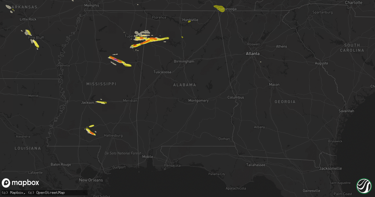
Hail Map in Alabama on March 9, 2017
Get this storm
March 9 map
$229
one time, instant access
Download today. No call, no setup
Keep the $229
Bought the map and want the full workflow? Apply the entire $229 to a subscription within 7 days. None of it is wasted.
Every map, not just this one
This buys you this map. Subscription and you get every map we run, in the markets you choose from a few cities to whole states to nationwide. Plus real-time alerts the moment a storm fires.
Contact data
Name, contact info, occupancy, even credit band for addresses in the footprint. You go from where it hit to who to call.
Become the source they trust
Unlimited branding weather history reports on demand. You already have the documented answer ready for the property owner, and you are the one who showed up with it.
Property data and RoofTrace estimates
Pull up any address you have got, its value and the exact code rules for that jurisdiction, straight from One Click Code. Then RoofTrace estimates the squares, pitch, and roof value, priced the way you price.
Storm reports in Alabama
Alabama
| Date | Description |
|---|---|
| 03/09/20174:20 AM CST | Trees reported down near the 1600 block of highway 31 north. Report via social media. |
| 03/09/20174:18 AM CST | Millbrook police dept. Reports tree across coosada road. Time estimated by radar. |
| 03/09/20174:16 AM CST | Large tree uprooted near millbrook. |
| 03/09/20174:12 AM CST | Roof damage to numerous structures in downtown wetumpka including coach's corner restaurant... Elmore scrap metals... The old fain theater building. |
| 03/09/20174:12 AM CST | Millbrook police dept reports tree on house on fieldcrest ct. Time estimated by radar. |
| 03/09/20174:12 AM CST | Tree down on road at intersection of hogan road and cold springs road near holtville. Report from elmore county sheriffs dept. Time estimated by radar. . |
| 03/09/20174:03 AM CST | Tree down on house in deatsvile. |
| 03/09/20173:57 AM CST | Trees reported down. Report via social media. |
| 03/09/20173:20 AM CST | Emergency manager reports tree down across hwy 148 between mile markers 5 and 10. Vehicle wrecked into downed tree. Time estimated by radar. |
| 03/09/20173:18 AM CST | Portion of tin roof removed from barn near ashland. Photo relayed via social media. |
| 03/09/20173:18 AM CST | Tree blown across both lanes of floyd springs road. Time estimated by radar. |
| 03/09/20173:18 AM CST | Emergency manager reports tree down across both lanes of royster road. Time estimated by radar. |
| 03/09/20173:16 AM CST | Trees down blocking the road. |
| 03/09/20173:16 AM CST | Trees down blocking the roadway. |
| 03/09/20173:13 AM CST | Trees down near the intersection of clairmont sprimgs road and highland road in the pyriton community. |
| 03/09/20173:12 AM CST | Emergency manager reports tree down at intersection of idaho rd. And mountain view rd. Time estimated by radar. |
| 03/09/20173:10 AM CST | Nws employee estimated 60mph gust at wfo. . |
| 03/09/20173:08 AM CST | Power lines down. |
| 03/09/20173:00 AM CST | Damage report at timber ridge golf course via social media. At least 8 trees down with some tops of trees torn off. Pump house damaged by falling trees. |
| 03/09/20173:00 AM CST | 2 trees reported down... One in a yard and the other onto a power line near the intersection of crestview road and mount olive circle. Report via social media. |
| 03/09/20173:00 AM CST | Some trees and power lines reported down across pickens county... Including trees down along cr12 and cr24. Estimated 40-50 mph winds. |
| 03/09/20172:55 AM CST | Tree and power lines down near intersection of old highway 280 and oak tree drive near chelsea... Road closed. |
| 03/09/20172:50 AM CST | Tree down near the intersection of hill avenue and pope drive in concord... Tree downed power lines causing power outage. |
| 03/09/20172:44 AM CST | Tree down on house along 42nd place north. |
| 03/09/20172:40 AM CST | Pleasant grove fire dept reporting tree down on 7th avenue. Time estimated by radar. |
| 03/09/20171:48 AM CST | Power pole reported down on home with power line attached in the rainsville area. |
| 03/09/20171:40 AM CST | Thunderstorm wind gusts estimated around 60 mph near arab. |
| 03/09/20171:30 AM CST | Two pine trees and one pecan tree uprooted. Penny sized hail also at location. Wind estimated at 55mph. . |
| 03/09/20171:28 AM CST | Thunderstorm wind gusts estimated near 60 mph in the crossville area. Dime size hail also reported. |
| 03/09/20171:28 AM CST | Several trees reported down near ider. |
| 03/09/20171:23 AM CST | Quarter size hail reported in south vinemont. |
| 03/09/201712:55 AM CST | Tree down on peck mountain road near gullian farms. |
| 03/09/201712:49 AM CST | Trees down on arvida drive near sherbrook drive. |
| 03/09/201712:45 AM CST | Quarter size hail reported at the intersection of golf road and south memorial parkway in huntsville. |
| 03/09/201712:15 AM CST | Power lines reported down just east of ardmore. A tree was also down that apparently was blocking a medical vehicle in the same area. |
| 03/09/201712:15 AM CST | Tree down on power lines on barksdale road in east limestone county. |
| 03/09/201712:10 AM CST | Quarter sized hail south of hackleburg at around 12:10am. . |
| 03/09/201712:05 AM CST | Tree reported down on one of the tree haven glen apartment complex buildings in huntsville. Twelve apartment units were affected. |
| 03/08/201711:52 PM CST | Hail larger than quarter-sized reported by public in the hamilton area. Time estimated by radar. |
| 03/08/20178:04 PM CST | . |
| 03/08/20178:01 PM CST | . |
| 03/08/20177:46 PM CST | Golfball size hail reported along highway 19 in the byrd community. |
| 03/08/20177:01 PM CST | Report relayed via social media. |
| 03/08/20176:35 PM CST | . |
| 03/08/20176:00 PM CST | Traveler reported hail covering the ground and it looked like snow cover. The largest piece was estimated at quarter size... But most was smaller. |
All States Impacted by Hail Map on March 9, 2017
Cities Impacted by Hail Map on March 9, 2017
- Lamar, MO
- Cedar Grove, TN
- Dover, TN
- Hazel, KY
- Buchanan, TN
- New Concord, KY
- Verona, MO
- Monett, MO
- Monticello, MS
- Tahlequah, OK
- Checotah, OK
- Trenton, KY
- Oak Grove, KY
- Shell Knob, MO
- Deepwater, MO
- Calhoun, MO
- Montrose, MO
- Lincoln, MO
- Warsaw, MO
- Roach, MO
- Macks Creek, MO
- Butler, MO
- Quincy, MO
- Linn Creek, MO
- Wheatland, MO
- Lowry City, MO
- Camdenton, MO
- Preston, MO
- Urich, MO
- Cross Timbers, MO
- Rich Hill, MO
- Windsor, MO
- Clinton, MO
- Appleton City, MO
- Osceola, MO
- Edwards, MO
- Climax Springs, MO
- Okemah, OK
- Ottawa, KS
- Baldwin City, KS
- Eufaula, OK
- Gonzales, TX
- Harwood, TX
- Murray, KY
- Cabool, MO
- Mountain Grove, MO
- Solo, MO
- Elk Creek, MO
- Grove, OK
- Tremont, MS
- Fulton, MS
- Nettleton, MS
- Hamilton, AL
- Hartshorn, MO
- Fort Gibson, OK
- Hulbert, OK
- Creighton, MO
- Aurora, MO
- West Plains, MO
- Cumberland City, TN
- Cumberland Furnace, TN
- Cunningham, TN
- Palmyra, TN
- Maysville, AR
- Fayetteville, AR
- Decatur, AR
- Gravette, AR
- Siloam Springs, AR
- Springdale, AR
- Gentry, AR
- Washburn, MO
- Exeter, MO
- McEwen, TN
- Overbrook, KS
- Pomona, KS
- Wellsville, KS
- Decaturville, TN
- Ava, MO
- Ponca, AR
- Brumley, MO
- Stoutland, MO
- Crocker, MO
- Montreal, MO
- Waynesville, MO
- Fort Leonard Wood, MO
- Richland, MO
- Yates Center, KS
- Piqua, KS
- Foxworth, MS
- Columbia, MS
- Jayess, MS
- Brookhaven, MS
- Norwood, MO
- Stigler, OK
- Poteau, OK
- Howe, OK
- Pelahatchie, MS
- Brandon, MS
- Morton, MS
- Jasper, MO
- Carthage, MO
- Maud, OK
- La Russell, MO
- Sarcoxie, MO
- Stotts City, MO
- Miller, MO
- Mount Vernon, MO
- Golden City, MO
- Reeds, MO
- Neosho, MO
- Granby, MO
- Centerville, KS
- Amory, MS
- Aberdeen, MS
- Smithville, MS
- Mansfield, MO
- Seymour, MO
- Marshfield, MO
- Fairland, OK
- Bentonville, AR
- Prairie Grove, AR
- Sulphur Springs, AR
- Lincoln, AR
- Farmington, AR
- Noel, MO
- Afton, OK
- West Fork, AR
- Elkins, AR
- Bluejacket, OK
- South West City, MO
- Colcord, OK
- Jay, OK
- Yellville, AR
- Carterville, MO
- Carl Junction, MO
- Joplin, MO
- Diamond, MO
- Webb City, MO
- Summersville, MO
- Birch Tree, MO
- Wentworth, MO
- Pierce City, MO
- Colony, KS
- Kincaid, KS
- Dora, MO
- Fair Grove, MO
- Brighton, MO
- Ash Grove, MO
- Buffalo, MO
- Walnut Grove, MO
- Pleasant Hope, MO
- Willard, MO
- Goodman, MO
- Seneca, MO
- Silver Creek, MS
- Castalian Springs, TN
- Lebanon, TN
- Eldridge, MO
- Lebanon, MO
- Watertown, TN
- Conway, MO
- Atwood, TN
- Haleyville, AL
- Mountain View, AR
- Hodges, AL
- Marietta, MS
- Red Bay, AL
- Golden, MS
- Mantachie, MS
- Vina, AL
- Iola, KS
- Fort Scott, KS
- Schell City, MO
- La Harpe, KS
- Harwood, MO
- Redfield, KS
- Deerfield, MO
- Bronson, KS
- Nevada, MO
- Uniontown, KS
- Richards, MO
- Moran, KS
- Moundville, MO
- Walker, MO
- El Dorado Springs, MO
- Hardy, AR
- Williford, AR
- Jackson, TN
- Smiley, TX
- Locust Grove, OK
- Pulaski, MS
- Everton, MO
- Morrisville, MO
- Elkland, MO
- Springfield, MO
- Eminence, MO
- Hartville, MO
- Yukon, MO
- Mountain View, MO
- Willow Springs, MO
- Houston, MO
- Licking, MO
- Raymondville, MO
- Pittsburg, KS
- Oronogo, MO
- Mindenmines, MO
- Liberal, MO
- Asbury, MO
- Galena, KS
- Lexington, TN
- Wildersville, TN
- Mayfield, KY
- Fisk, MO
- Broseley, MO
- Greenwood Springs, MS
- Double Springs, AL
- Plantersville, MS
- Okolona, MS
- Guin, AL
- Hackleburg, AL
- Bear Creek, AL
- Detroit, AL
- Navasota, TX
- Plantersville, TX
- Anderson, TX
- Eureka Springs, AR
- Eagle Rock, MO
- Theodosia, MO
- Thornfield, MO
- Mathiston, MS
- Eupora, MS
- Walthall, MS
- Maben, MS
- Starkville, MS
- Oxly, MO
- Doniphan, MO
- Cassville, MO
- Pleasanton, KS
- Clifton, TN
- Taneyville, MO
- Freer, TX
- Lampe, MO
- Golden, MO
- Calico Rock, AR
- Norfork, AR
- Fordland, MO
- Ackerman, MS
- Strafford, MO
- Cove, AR
- Crane, MO
- Marionville, MO
- Reeds Spring, MO
- Blue Eye, MO
- Branson, MO
- Columbus, KS
- Hollister, MO
- Valley Springs, AR
- Flippin, AR
- Berryville, AR
- Fifty Six, AR
- Frontenac, KS
- Pyatt, AR
- Spokane, MO
- Timbo, AR
- Onia, AR
- Rueter, MO
- Chestnutridge, MO
- Kimberling City, MO
- Everton, AR
- Harrison, AR
- Forsyth, MO
- Pleasant Grove, AR
- Rockaway Beach, MO
- Oak Grove, AR
- Purdy, MO
- Billings, MO
- Cedarcreek, MO
- Harriet, AR
- Cape Fair, MO
- Saint Joe, AR
- Kissee Mills, MO
- Peel, AR
- Green Forest, AR
- Lead Hill, AR
- Powersite, MO
- Melbourne, AR
- Kirbyville, MO
- Galena, MO
- Protem, MO
- Freistatt, MO
- Summit, AR
- Walnut Shade, MO
- Ridgedale, MO
- Big Flat, AR
- Omaha, AR
- Stark City, MO
- Benton, KY
- Quinton, OK
- Mcalester, OK
- Nashville, TN
- Puxico, MO
- Bloomfield, MO
- Linden, TN
- Summertown, TN
- Lawrenceburg, TN
- Ethridge, TN
- Stella, MO
- Anderson, MO
- Powell, MO
- Bells, TN
- Gadsden, TN
- Beech Bluff, TN
- Oakfield, TN
- Huron, TN
- Humboldt, TN
- Scotts Hill, TN
- Murfreesboro, TN
- Readyville, TN
- Vanzant, MO
- Buffalo Valley, TN
- Silver Point, TN
- Pocahontas, AR
- Maynard, AR
- Smithville, OK
- Watson, OK
- Vian, OK
- Pryor, OK
- Paola, KS
- Louisburg, KS
- Spring Hill, KS
- Edgerton, KS
- Bucyrus, KS
- Lancaster, TN
- Baxter, TN
- Hickman, TN
- Perryville, AR
- Seminole, OK
- Williamsville, MO
- Grandin, MO
- Ellsinore, MO
- Park Hill, OK
- Cookson, OK
- Wingo, KY
- Fancy Farm, KY
- Clinton, KY
- Ozark, MO
- Nixa, MO
- Newburg, MO
- Hermitage, TN
- Antioch, TN
- Mount Juliet, TN
- Campbell, MO
- Poplar Bluff, MO
- Qulin, MO
- Parma, MO
- Dexter, MO
- Naylor, MO
- Malden, MO
- Neelyville, MO
- Van Buren, MO
- Winona, MO
- Harviell, MO
- Fairdealing, MO
- Fremont, MO
- Wappapello, MO
- Bernie, MO
- Catron, MO
- Clarksville, TN
- Adams, TN
- Columbus, MS
- Butterfield, MO
- Avilla, MO
- Oakland, AR
- Marcella, AR
- Osawatomie, KS
- Rantoul, KS
- Mena, AR
- Rogersville, MO
- Alton, MO
- Gideon, MO
- Lilbourn, MO
- Wardell, MO
- Clarkton, MO
- Portageville, MO
- Brookline, MO
- Salem, MO
- Peace Valley, MO
- Alpena, AR
- Falls City, TX
- Campbellton, TX
- Brush Creek, TN
- Woodlawn, TN
- Indian Mound, TN
- Dickson, TN
- Pottersville, MO
- Keota, OK
- Ellington, MO
- Water Valley, KY
- Fulton, KY
- Falcon, MO
- Laquey, MO
- Proctor, OK
- Earlsboro, OK
- Bokoshe, OK
- Garden City, MO
- Blairstown, MO
- Moody, MO
- Hermitage, MO
- Plato, MO
- Duke, MO
- Dexter, KY
- Sheridan, AR
- White Hall, AR
- Eagleville, TN
- Rockvale, TN
- Chapel Hill, TN
- Unionville, TN
- Lewisburg, TN
- Columbia, TN
- Quenemo, KS
- Madison, TN
- Le Roy, KS
- Burlington, KS
- Mapleton, KS
- Fulton, KS
- Hume, MO
- Heavener, OK
- Paragould, AR
- Cedar Hill, TN
- Tennessee Ridge, TN
- Caulfield, MO
- Tecumseh, MO
- Mcdonough, GA
- Batesville, AR
- Cleveland, MO
- Freeman, MO
- Cameron, OK
- Gardner, KS
- Drury, MO
- Red Oak, OK
- Fairview, TN
- Kingston Springs, TN
- Foster, MO
- Amoret, MO
- Pegram, TN
- Ashland City, TN
- White Bluff, TN
- Burns, TN
- Hardin, KY
- Eagletown, OK
- Success, MO
- Roby, MO
- Pine Bluff, AR
- Star City, AR
- Rison, AR
- Henning, TN
- Peggs, OK
- Gillham, AR
- De Queen, AR
- Humboldt, KS
- Mount Pleasant, TN
- Salem, AR
- Mammoth Spring, AR
- Elmwood, TN
- Cookeville, TN
- Gordonsville, TN
- Bon Aqua, TN
- Alexandria, TN
- Gates, TN
- Huggins, MO
- Pineville, MO
- Lanagan, MO
- Buffalo, KS
- Springville, TN
- Sontag, MS
- Bucyrus, MO
- Lynchburg, MO
- Windyville, MO
- Long Lane, MO
- Louisburg, MO
- Tunas, MO
- Lenox, MO
- Beulah, MO
- Edgar Springs, MO
- Harrisonville, MO
- Archie, MO
- Morris, OK
- Cadiz, KY
- Almo, KY
- Puryear, TN
- Half Way, MO
- Urbana, MO
- Kirksey, KY
- Konawa, OK
- Strawberry, AR
- Sparta, MO
- Webbers Falls, OK
- East Prairie, MO
- Drexel, MO
- Whites Creek, TN
- Hayti, MO
- Waynesboro, TN
- Parsons, TN
- Bruner, MO
- Wynne, AR
- Friendship, TN
- Halls, TN
- Pineville, AR
- Denmark, TN
- Mercer, TN
- Farmington, KY
- Dyersburg, TN
- Ridgely, TN
- Newbern, TN
- Huntsville, AR
- Holladay, TN
- Charleston, MO
- Newport, AR
- Bertrand, MO
- Braggs, OK
- Gore, OK
- Muskogee, OK
- South Greenfield, MO
- Greenfield, MO
- Bois D Arc, MO
- Tiptonville, TN
- Stantonville, TN
- Jadwin, MO
- Niangua, MO
- Burlingame, KS
- Seligman, MO
- Pomona, MO
- Deer, AR
- Wickliffe, KY
- Kevil, KY
- Bolivar, MO
- Obion, TN
- La Vernia, TX
- Encinal, TX
- Ravenden Springs, AR
- Shady Point, OK
- Blue Springs, MS
- Reagan, TN
- Alamo, TN
- Yuma, TN
- Darden, TN
- Medina, TN
- Muldrow, OK
- Gans, OK
- Sallisaw, OK
- Henderson, TN
- Medon, TN
- Pinson, TN
- Amsterdam, MO
- Chouteau, OK
- Big Sandy, TN
- Hartshorne, OK
- Wilburton, OK
- Canadian, OK
- Caruthersville, MO
- Steele, MO
- Finley, TN
- Ponce De Leon, MO
- Oil Trough, AR
- Magness, AR
- Rosie, AR
- Stover, MO
- Spiro, OK
- Christiana, TN
- Milton, TN
- Woodbury, TN
- Hurricane Mills, TN
- Waverly, TN
- Macon, GA
- Dry Branch, GA
- Bradleyville, MO
- Melber, KY
- Bardwell, KY
- Hickory, KY
- Cunningham, KY
- Boaz, KY
- Gainesville, MO
- Zanoni, MO
- Dardanelle, AR
- Morrilton, AR
- Casa, AR
- Porter, OK
- Rocky Comfort, MO
- Nauvoo, AL
- Hickory Ridge, AR
- Hohenwald, TN
- Lockwood, MO
- Fisher, AR
- Huntingdon, TN
- Lavinia, TN
- Milan, TN
- Buena Vista, TN
- La Fayette, KY
- Herndon, KY
- Holden, MO
- Vinita, OK
- Wyandotte, OK
- Lyndon, KS
- Vassar, KS
- Compton, AR
- Kingston, AR
- Jasper, AR
- Parthenon, AR
- Oak Vale, MS
- Adona, AR
- Pottsville, AR
- Republic, MO
- Wister, OK
- Hampshire, TN
- Saint Robert, MO
- Paris, TN
- Clarksville, AR
- Hartman, AR
- Kennett, MO
- Gobler, MO
- Hornersville, MO
- Blue Mound, KS
- Mound City, KS
- Imboden, AR
- Smithville, AR
- Black Rock, AR
- Wright City, OK
- Wagoner, OK
- Nashoba, OK
- Garfield, AR
- Scranton, AR
- New Blaine, AR
- Aldrich, MO
- Dadeville, MO
- Rogers, AR
- Wickes, AR
- Mantee, MS
- Pittsburg, MO
- Senath, MO
- Ada, OK
- Tupelo, MS
- Mooreville, MS
- Isabella, MO
- Monterey, TN
- Dukedom, TN
- Lascassas, TN
- Squires, MO
- Koshkonong, MO
- Covington, GA
- Stockbridge, GA
- Cottage Grove, TN
- Sedalia, KY
- Hornbeak, TN
- Bell City, MO
- Sikeston, MO
- Pea Ridge, AR
- Chadwick, MO
- Oldfield, MO
- Scranton, KS
- Broken Bow, OK
- Rattan, OK
- Stark, KS
- Hepler, KS
- Gamaliel, AR
- Henderson, AR
- Gepp, AR
- Clarkridge, AR
- Hatfield, AR
- Jefferson, AR
- Goodlettsville, TN
- Culleoka, TN
- Bell Buckle, TN
- Liberty, TN
- Cornersville, TN
- Petersburg, TN
- Belfast, TN
- Tullahoma, TN
- Gore Springs, MS
- Pheba, MS
- Bellefontaine, MS
- Houston, AL
- Cullman, AL
- Vinemont, AL
- Miami, OK
- Porum, OK
- Whiteside, TN
- Chattanooga, TN
- Wildwood, GA
- Guild, TN
- Sequatchie, TN
- Whitwell, TN
- Jasper, TN
- Trenton, GA
- South Pittsburg, TN
- Huntsville, AL
- Prentiss, MS
- Neosho Falls, KS
- Collins, MO
- Weaubleau, MO
- Macomb, MO
- Holcomb, MO
- Piggott, AR
- Saint Francis, AR
- Gibson, MO
- Greenville, MO
- Cardwell, MO


