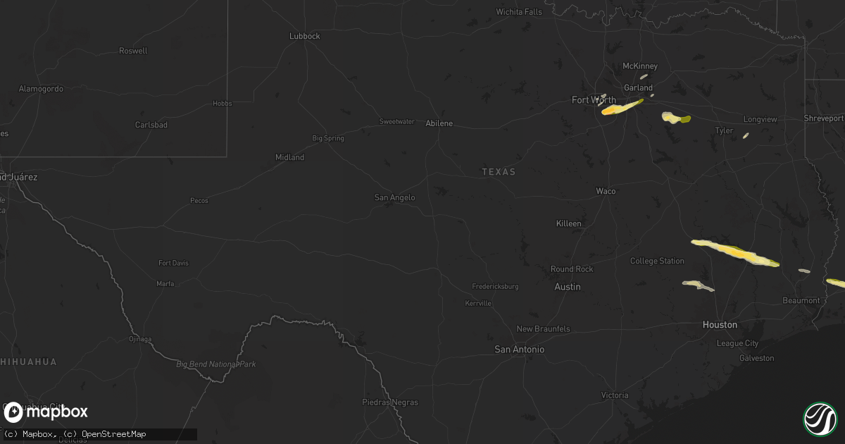
Hail Map in Texas on March 8, 2025
Get this storm
March 8 map
$229
one time, instant access
Download today. No call, no setup
Keep the $229
Bought the map and want the full workflow? Apply the entire $229 to a subscription within 7 days. None of it is wasted.
Every map, not just this one
This buys you this map. Subscription and you get every map we run, in the markets you choose from a few cities to whole states to nationwide. Plus real-time alerts the moment a storm fires.
Contact data
Name, contact info, occupancy, even credit band for addresses in the footprint. You go from where it hit to who to call.
Become the source they trust
Unlimited branding weather history reports on demand. You already have the documented answer ready for the property owner, and you are the one who showed up with it.
Property data and RoofTrace estimates
Pull up any address you have got, its value and the exact code rules for that jurisdiction, straight from One Click Code. Then RoofTrace estimates the squares, pitch, and roof value, priced the way you price.
Storm reports in Texas
Texas
| Date | Description |
|---|---|
| 03/08/20255:47 PM CST | A local report indicates 1.50 inch wind near 5 SSE Onalaska |
| 03/08/20255:31 PM CST | A local report indicates 1.00 inch wind near Point Blank |
| 03/08/20255:29 PM CST | A local report indicates 1.00 inch wind near 1 WNW Point Blank |
| 03/08/20257:23 AM CST | Delayed report from mping. Quarter-sized hail 2 miles north of wylie. |
| 03/08/20256:26 AM CST | Report from mping: quarter |
| 03/08/20256:25 AM CST | Collapsed metal multi vehicle shed. Time estimated. |
| 03/08/20256:25 AM CST | Delayed report. Social media pictures of damaged wooden/metal buildings |
| 03/08/20256:22 AM CST | A local report indicates 1.00 inch wind near 1 NW Desoto |
| 03/08/20256:09 AM CST | Report from mping: half dollar |
| 03/08/20256:07 AM CST | Report from mping: half dollar |
| 03/08/20256:05 AM CST | Report from mping: golf ball |
| 03/07/20256:20 PM CST | A local report indicates 1.25 inch wind near 2 SE Livingston |
| 03/07/20256:05 PM CST | A local report indicates 1.00 inch wind near 1 W Livingston |
| 03/07/20256:00 PM CST | A local report indicates 1.00 inch wind near 5 WSW Livingston |
All States Impacted by Hail Map on March 8, 2025
Cities Impacted by Hail Map on March 8, 2025
- Rising Star, TX
- Novice, TX
- Coleman, TX
- Burkett, TX
- Cross Plains, TX
- Fort Worth, TX
- Lipan, TX
- Mansfield, TX
- Bluff Dale, TX
- Cresson, TX
- Granbury, TX
- Burleson, TX
- Tolar, TX
- Crowley, TX
- Joshua, TX
- Godley, TX
- Ferris, TX
- Ennis, TX
- Rosser, TX
- Maypearl, TX
- Nemo, TX
- Rainbow, TX
- Grandview, TX
- Glen Rose, TX
- Venus, TX
- Waxahachie, TX
- Midlothian, TX
- Scurry, TX
- Cleburne, TX
- Palmer, TX
- Alvarado, TX
- Stephenville, TX
- Arlington, TX
- Grand Prairie, TX
- Cedar Hill, TX
- Kemp, TX
- Kaufman, TX
- Mabank, TX
- Dallas, TX
- Desoto, TX
- Duncanville, TX
- Lancaster, TX
- Hutchins, TX
- Canton, TX
- Bedford, TX
- Hurst, TX
- Euless, TX
- Balch Springs, TX
- Mesquite, TX
- Grand Saline, TX
- Ben Wheeler, TX
- Van, TX
- Lindale, TX
- Forney, TX
- Sunnyvale, TX
- Rockwall, TX
- Wylie, TX
- Allen, TX
- Plano, TX
- Royse City, TX
- Quinlan, TX
- Princeton, TX
- Nevada, TX
- Farmersville, TX
- Brashear, TX
- Mount Pleasant, TX
- Overton, TX
- Kilgore, TX
- Huntsville, TX
- Midway, TX
- Vicksburg, MS
- Port Gibson, MS
- Utica, MS
- Hermanville, MS
- Terry, MS
- Crystal Springs, MS
- Oakhurst, TX
- Pointblank, TX
- Plantersville, TX
- Navasota, TX
- Florence, MS
- Onalaska, TX
- Livingston, TX
- Montgomery, TX
- Braxton, MS
- Coldspring, TX
- Magnolia, TX
- Conroe, TX
- Goodrich, TX
- Spring, TX
- Warren, TX
- Kountze, TX
- Silsbee, TX
- Buna, TX
- Starks, LA
- Dequincy, LA
- Vinton, LA
- Sulphur, LA
- Westlake, LA
- Lake Charles, LA
- Iowa, LA
- Sumrall, MS
- Bassfield, MS
- Seminary, MS
- Ellisville, MS
- Coden, AL
- Meadville, MS
- Smithdale, MS
- McCall Creek, MS
- Bogue Chitto, MS
- Brookhaven, MS
- Theodore, AL
- Bayou La Batre, AL
- Moselle, MS
- Petal, MS
- Hattiesburg, MS
- Collins, MS
- Columbia, MS
- Richton, MS
- Carson, MS
- Ovett, MS
- Laurel, MS


