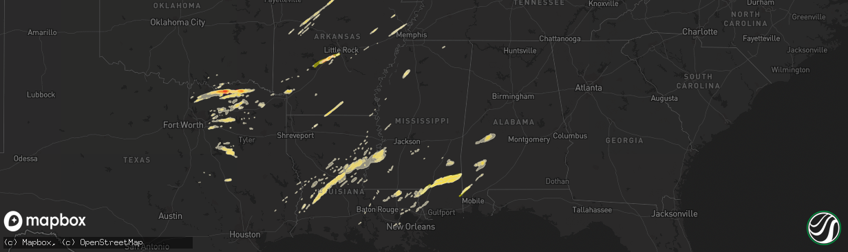
Hail Map in Mississippi on March 8, 2011
The weather event in Mississippi on March 8, 2011 includes Hail map. 8 states and 367 cities were impacted and suffered possible damage. The total estimated number of properties impacted is 8,179.
Want more than just the map?
Turn this storm into a full workflow.
- Owner + property data so you know who to knock
- OnDemand branded weather history reports to win the "did we even have hail?" argument
- RoofTrace estimate so reps stop guessing numbers at the door
Bought this map? Upgrade within 7 days and we'll credit the $230. (10-15 min setup call)
Hail
8,179
Estimated number of impacted properties by a 1.00" hail or larger0
Estimated number of impacted properties by a 1.75" hail or larger0
Estimated number of impacted properties by a 2.50" hail or largerStorm reports in Mississippi
Mississippi
| Date | Description |
|---|---|
| 03/08/20115:56 PM CST | A local report indicates 1.00 inch wind near 2 NW LUMBERTON |
| 03/08/20112:19 PM CST | Large limbs were reported down. |
| 03/08/20115:46 AM CST | Tree limbs down throughout city. |
| 03/08/20115:25 AM CST | Trees down goodyear blvd in picayune. Possible tornado... Surveys this morning. |
| 03/08/20115:25 AM CST | Survey has determined that the damage in the picayune area is a confirmed ef1 tornado with a path of 3 miles and an estimated width of 100 yards. The track starts with |
| 03/08/20113:15 AM CST | Minor roof damage reported to one residence |
| 03/08/20113:01 AM CST | A few trees down along hwy 35n and 501. |
| 03/08/20112:21 AM CST | A few power lines down along hwy 552 |
| 03/08/20112:08 AM CST | Powerlines down at luckney road and mary miles drive. Also some minor tree damage reported in area. |
| 03/08/20111:34 AM CST | Trees down along old port gibson road near mt. Moriah road. |
| 03/08/20111:34 AM CST | Tornado rated ef-2 with 115 mph winds tracked for three miles from 3 nw of terry to 5 nnw of terry and had a path width of 150 yds...numerous trees snapped or uprooted |
| 03/08/20111:30 AM CST | Tree down on powerlines |
| 03/08/20111:27 AM CST | Trees and power lines were downed along bridewell ln...causing power outages throughout the city. |
| 03/08/20111:24 AM CST | Trees down along old highway 51 near the copiah county line. |
| 03/08/20111:11 AM CST | Trees and power lines down on ernie martin rd and hickstown rd. A mobile home had the roof blown off. Possible tornado. |
| 03/08/20111:08 AM CST | This tornado was on the ground for 6 miles. It had maximum winds of 95 mph and a max width of 250 yards. Numerous trees were snapped and uprooted...and damage occurred |
| 03/08/201112:30 AM CST | A few power lines down along hwy 552 |
| 03/08/201112:27 AM CST | Mobile home blown off its blocks on wolfe circle |
| 03/08/201112:25 AM CST | Trees and power lines were downed along bridewell ln...causing power outages throughout the city. |
| 03/07/20118:36 PM CST | Trees reported down by fox40 |
| 03/07/20118:00 PM CST | Public reported quarter size hail 4 miles southwest of avera near the intersection of tung oil and neely-avera roads. |
| 03/07/20117:14 PM CST | Multiple trees down across carmel-new hope road and olivar wilson road. |
| 03/07/20116:55 PM CST | A local report indicates 1.00 inch wind near 4 SE HATTIESBURG |
| 03/07/20116:46 PM CST | A local report indicates 1.00 inch wind near ROCK HILL |
| 03/07/20116:30 PM CST | Tree down on lost john road. Time estimated from radar |
All States Impacted by Hail Map on March 8, 2011
Cities Impacted by Hail Map on March 8, 2011
- Clayton, LA
- Eudora, AR
- Nashville, AR
- Mineral Springs, AR
- Angie, LA
- Maringouin, LA
- Grosse Tete, LA
- New Boston, TX
- De Kalb, TX
- England, AR
- Carlisle, AR
- Lonoke, AR
- Winnsboro, LA
- Pollock, LA
- Jena, LA
- Ravenna, TX
- Dike, TX
- Sulphur Springs, TX
- Strong, AR
- Hermitage, AR
- Jersey, AR
- Lillie, LA
- Summerfield, LA
- Junction City, AR
- El Dorado, AR
- Biscoe, AR
- De Valls Bluff, AR
- Franklinton, LA
- Bogalusa, LA
- Royse City, TX
- Nevada, TX
- Malvern, AR
- Hot Springs National Park, AR
- Pineville, LA
- Lambert, MS
- Enid, MS
- Tutwiler, MS
- Batesville, MS
- Delhi, LA
- Clarksville, AR
- Pitkin, LA
- Singer, LA
- Earle, AR
- Grove Hill, AL
- Jackson, AL
- Lorman, MS
- Leesville, LA
- Point, TX
- Bismarck, AR
- Burkeville, TX
- Dickinson, AL
- Saint Stephens, AL
- Whatley, AL
- Leroy, AL
- Thomasville, AL
- Lamar, AR
- Mountain Home, AR
- Neely, MS
- Leakesville, MS
- Jasper, TX
- Kirbyville, TX
- Sicily Island, LA
- Harrisonburg, LA
- Jonesville, LA
- Ferriday, LA
- Magazine, AR
- Booneville, AR
- Pocahontas, AR
- Ravenden Springs, AR
- Pilot Point, TX
- Groesbeck, TX
- Paris, TX
- Harriet, AR
- Marshall, AR
- Athens, TX
- Malakoff, TX
- Centerville, TX
- Trumann, AR
- Harrisburg, AR
- Benton, AR
- Laurel, MS
- Shubuta, MS
- Waynesboro, MS
- Heidelberg, MS
- Blossom, TX
- Brookston, TX
- Honey Grove, TX
- Windom, TX
- Sumner, TX
- Roxton, TX
- Savoy, TX
- Dodd City, TX
- Bells, TX
- Bonham, TX
- Detroit, TX
- Telephone, TX
- Sherman, TX
- Petty, TX
- Bauxite, AR
- Citronelle, AL
- Chunchula, AL
- Forest, MS
- Brinkley, AR
- Wheatley, AR
- Colfax, LA
- Dry Prong, LA
- Bentley, LA
- Sulphur Bluff, TX
- Cumby, TX
- Cooper, TX
- Quinlan, TX
- Rockwall, TX
- Lavon, TX
- Ivanhoe, TX
- Hendrix, OK
- Dequincy, LA
- Port Gibson, MS
- Fayette, MS
- Hineston, LA
- Grant, LA
- Deridder, LA
- Glenmora, LA
- Pattison, MS
- Deville, LA
- Elizabeth, LA
- Effie, LA
- Newellton, LA
- Natchez, MS
- Center Point, LA
- Waterproof, LA
- Longville, LA
- Hermanville, MS
- Lecompte, LA
- Alexandria, LA
- Elmer, LA
- Mittie, LA
- Saint Joseph, LA
- Forest Hill, LA
- Dry Creek, LA
- Sugartown, LA
- Woodworth, LA
- Vidalia, LA
- Vicksburg, MS
- Trout, LA
- Jackson, LA
- Celina, TX
- Gunter, TX
- Winnsboro, TX
- Wesson, MS
- McCall Creek, MS
- Brookhaven, MS
- Poyen, AR
- Traskwood, AR
- Parkin, AR
- Fluker, LA
- Roseland, LA
- Kentwood, LA
- Amite, LA
- Greensburg, LA
- Bagwell, TX
- Ector, TX
- Collinsville, TX
- Tom Bean, TX
- Clarksville, TX
- Ladonia, TX
- Wolfe City, TX
- Howe, TX
- Leonard, TX
- Whitewright, TX
- Pattonville, TX
- Van Alstyne, TX
- Tioga, TX
- Independence, KS
- Terrell, TX
- Wills Point, TX
- Paris, AR
- Valley View, TX
- Kountze, TX
- London, AR
- Scranton, AR
- Knoxville, AR
- New Blaine, AR
- Crandall, TX
- Kaufman, TX
- Forney, TX
- Seagoville, TX
- Hagarville, AR
- Palestine, TX
- Montalba, TX
- Pelsor, AR
- Dover, AR
- Mount Judea, AR
- Anacoco, LA
- Hardy, AR
- Ravenden, AR
- Myrtle, MO
- Williford, AR
- Couch, MO
- Doniphan, MO
- Gatewood, MO
- Yellville, AR
- Flippin, AR
- Hartman, AR
- Saint Joe, AR
- Mabelvale, AR
- Little Rock, AR
- Alexander, AR
- Hector, AR
- Crawfordsville, AR
- Gilmore, AR
- Turrell, AR
- Fruitdale, AL
- Lumberton, MS
- Richton, MS
- Columbia, MS
- State Line, MS
- Beaumont, MS
- Hattiesburg, MS
- Petal, MS
- Purvis, MS
- Poplarville, MS
- McLain, MS
- New Augusta, MS
- Starks, LA
- Marion Junction, AL
- Demopolis, AL
- Sweet Water, AL
- Gallion, AL
- Uniontown, AL
- Linden, AL
- Faunsdale, AL
- Safford, AL
- Newbern, AL
- Thomaston, AL
- Greenville, TX
- Amity, AR
- Commerce, TX
- Talco, TX
- Klondike, TX
- Deport, TX
- Brashear, TX
- Lake Creek, TX
- Quitman, TX
- Ethel, LA
- Wilson, LA
- Merryville, LA
- Ogden, AR
- Ashdown, AR
- Fulton, AR
- Lone Oak, TX
- Fort Polk, LA
- Augusta, AR
- McCrory, AR
- Emory, TX
- Evans, LA
- Loranger, LA
- Husser, LA
- Tennessee Colony, TX
- Woodville, MS
- Eustace, TX
- La Place, LA
- Norco, LA
- Bryant, AR
- Marksville, LA
- Florence, MS
- Braxton, MS
- Subiaco, AR
- Calico Rock, AR
- Larue, TX
- Minden, LA
- Fruitvale, TX
- Mabank, TX
- Midway, AR
- Murfreesboro, AR
- Trinidad, TX
- Homer, LA
- Norwood, LA
- Norfork, AR
- Como, TX
- Delaware, AR
- Mount Pleasant, TX
- Enloe, TX
- Winnfield, LA
- Georgetown, LA
- Picayune, MS
- Hawkins, TX
- Falkner, MS
- Acme, LA
- Newton, TX
- Gilbert, LA
- Lena, LA
- Erwinville, LA
- Port Allen, LA
- Bennington, OK
- Loreauville, LA
- New Iberia, LA
- Mead, OK
- Durant, OK
- Harrisville, MS
- Big Sandy, TX
- Spurger, TX
- Mendenhall, MS
- Bokchito, OK
- Oak Grove, LA
- Wilmer, AL
- Campbell, TX
- Bogata, TX
- Ponchatoula, LA
- Valley Park, MS
- Yazoo City, MS
- Rolling Fork, MS
- Gainesville, TX
- Witts Springs, AR
- Kemp, TX
- Kerens, TX
- Monterey, LA
- Fort Necessity, LA
- Reagan, TX
- Farmersville, TX
- Leland, MS
- Caddo, OK
- Caddo Mills, TX
- Celeste, TX
- Covington, LA
- Boyce, LA
- Pecan Gap, TX
- Mount Vernon, AL
- Lucedale, MS
- Alba, TX
- Pine Grove, LA
- Clinton, LA
- Denham Springs, LA
- Greenwell Springs, LA
- Colt, AR
- Wynne, AR
- Forrest City, AR
- Omaha, TX
- Cherokee Village, AR
- Cookville, TX
- Russellville, AR
- Tullos, LA
- Lacombe, LA
- Carriere, MS
- Pearl River, LA
- Slidell, LA
- Pittsburg, TX
- Thornton, TX
- Bush, LA
- Abita Springs, LA
- Pickton, TX
- Sondheimer, LA
- Mount Vernon, TX
- Scroggins, TX
- Olla, LA
- Chidester, AR
- Madisonville, LA
- Sieper, LA
- Lockesburg, AR
- Horatio, AR
- Havana, AR
- Mount Olive, MS
- Mize, MS
- Hessmer, LA
- Cheneyville, LA
- Meadville, MS
- Edgard, LA
- Donaldson, AR


