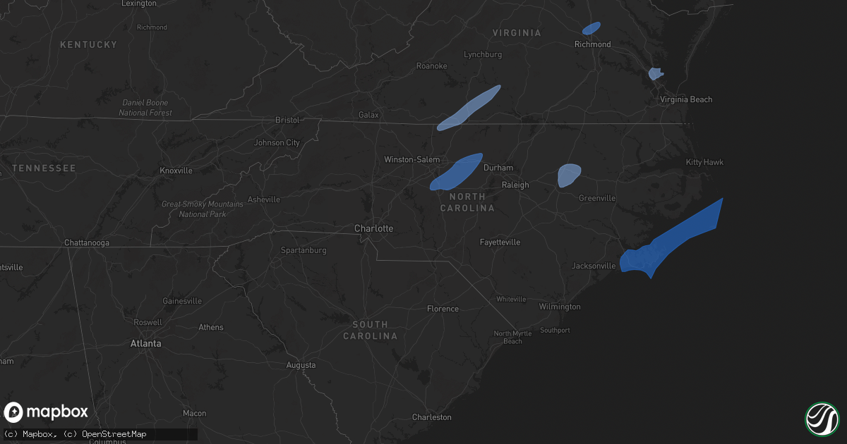
Hail Map in North Carolina on March 5, 2025
Get this storm
March 5 map
$229
one time, instant access
Download today. No call, no setup
Keep the $229
Bought the map and want the full workflow? Apply the entire $229 to a subscription within 7 days. None of it is wasted.
Every map, not just this one
This buys you this map. Subscription and you get every map we run, in the markets you choose from a few cities to whole states to nationwide. Plus real-time alerts the moment a storm fires.
Contact data
Name, contact info, occupancy, even credit band for addresses in the footprint. You go from where it hit to who to call.
Become the source they trust
Unlimited branding weather history reports on demand. You already have the documented answer ready for the property owner, and you are the one who showed up with it.
Property data and RoofTrace estimates
Pull up any address you have got, its value and the exact code rules for that jurisdiction, straight from One Click Code. Then RoofTrace estimates the squares, pitch, and roof value, priced the way you price.
Storm reports in North Carolina
North Carolina
| Date | Description |
|---|---|
| 03/05/20255:18 PM CST | Measured at the avon weatherflow. Anemometer height is 39 feet. |
| 03/05/20255:04 PM CST | Frisco woods weatherflow. |
| 03/05/20254:49 PM CST | 911 center reported the entire island of ocracoke is without power. Time estimated based on the peak wind gust at the ocracoke lighthouse. |
| 03/05/20254:06 PM CST | Several personal weather stations showed thunderstorm wind gusts of 50 to 60 knots on harkers island. |
| 03/05/20253:45 PM CST | Power lines down throughout perquimans county. |
| 03/05/20253:39 PM CST | Power lines down. Time estimated. |
| 03/05/20253:35 PM CST | Corrects previous tstm wnd gst report from 1 e havelock. Measured by knkt asos. |
| 03/05/20253:35 PM CST | Carteret-craven electric cooperative reported limbs on powerlines on speight street in havelock. |
| 03/05/20253:35 PM CST | Measured by knkt asos. |
| 03/05/20253:17 PM CST | A tree was blown down across the road at the intersection of star hill rd and pine lake rd. The time was estimated based on radar data. |
| 03/05/20252:52 PM CST | Power lines down on jack branch road. Time estimated. |
| 03/05/20252:46 PM CST | Some very minor damage to a barn... With damage to the studs. At the same location a tree was snapped at the base. Time estimated by radar. |
| 03/05/20252:40 PM CST | A tree fell on a house and caused ceiling damage. |
| 03/05/20252:24 PM CST | Nos station on johnnie mercers pier measured a sustained wind of 56 mph with a peak gust to 71 mph at 50 ft above msl. |
| 03/05/20252:15 PM CST | Tree down in scotland neck near rt 258. |
| 03/05/20252:15 PM CST | Barn damaged near lawrence. |
| 03/05/20252:12 PM CST | Multiple trees down along dobbs farm road. Time estimated by radar. |
| 03/05/20252:12 PM CST | Multiple trees down along albrittons road. |
| 03/05/20252:11 PM CST | Trees down along hillman road. |
| 03/05/20252:10 PM CST | Tree down in pinetops. |
| 03/05/20252:05 PM CST | Trees down in macclesfield near fountain road. |
| 03/05/20252:04 PM CST | Branches down and also dime size hail reported. |
| 03/05/20251:41 PM CST | Duke energy reported outage of 2000 people caused by fallen trees or limbs damaging equipment. |
| 03/05/20251:40 PM CST | Multiple fences blown over in neighborhood. Wind gust measured on home weather station. |
| 03/05/20251:38 PM CST | Numerous trees down in the airport blvd area of wilson. Trees reported down on bridgers street... Bell street... Christopher drive... Hart avenue and others. Some tress |
| 03/05/20251:31 PM CST | Duke energy reported outage caused by fallen trees or limbs damaging equipment. |
| 03/05/20251:30 PM CST | Spotter reported multiple large branches down. |
| 03/05/20251:20 PM CST | Tree reported down in enfield. |
| 03/05/20251:15 PM CST | Trees down in roanoke rapids. |
| 03/05/20251:10 PM CST | Tree and some property damage near the intersection of healthy plains road & high road. |
| 03/05/202512:50 PM CST | Duke energy reported outage caused by fallen trees or limbs damaging equipment. |
| 03/05/202512:45 PM CST | Several reports of trees down... Mainly in southeastern warren county near centerville. |
| 03/05/202512:30 PM CST | Tree down near gannon avenue. |
| 03/05/202512:05 PM CST | Duke energy reported outage caused by fallen trees or limbs damaging equipment. |
| 03/05/202511:33 AM CST | Trees down near i440 and glenwood dr. |
| 03/05/202511:30 AM CST | Broadcast news reported a tree split and down. Time estimated based on radar. |
| 03/05/202511:18 AM CST | Trees down in north raleigh neighborhood from tv media. |
| 03/05/202511:15 AM CST | Multiple trees down in henderson including near oxford road and raleigh road. |
| 03/05/202511:12 AM CST | Duke energy reported outage caused by fallen trees or limbs damaging equipment. |
| 03/05/202511:10 AM CST | Duke energy reported outage caused by fallen trees or limbs damaging equipment. |
| 03/05/202511:01 AM CST | Trees down and power outages. |
| 03/05/202510:59 AM CST | Duke energy reported outage caused by fallen trees or limbs damaging equipment. |
| 03/05/202510:33 AM CST | Duke energy reported outage caused by fallen trees or limbs damaging equipment. |
| 03/05/202510:30 AM CST | Tree down on bass road. |
| 03/05/202510:15 AM CST | Tree down at the intersection of morgan street and berry street. |
| 03/05/202510:13 AM CST | Trees down and power outage. |
| 03/05/20259:40 AM CST | Law enforcement reports multiple trees down in chatham county including pittsboro. |
| 03/05/20259:30 AM CST | Tree on a residence in 2400 block of mckinney st.... Burlington... Nc. |
| 03/05/20259:29 AM CST | Duke energy reported outage caused by fallen trees or limbs damaging equipment. |
| 03/05/20259:20 AM CST | Law enforcement reports multiple trees down in chatham county including one down in bear creek near old route 421. |
| 03/05/20259:15 AM CST | Law enforcement reports multiple trees down in chatham county including one down in siler city. |
| 03/05/20259:12 AM CST | Duke energy reported outage caused by fallen trees or limbs damaging equipment. |
| 03/05/20259:11 AM CST | 60 mph thunderstorm wind gust at kbuy. |
| 03/05/20259:06 AM CST | Duke energy reported an outage caused by fallen trees or limbs damaging equipment. |
| 03/05/20258:58 AM CST | Tree down on 2200 block of w o w rd. |
| 03/05/20258:40 AM CST | Tree down next to home in pleasant garden. |
| 03/05/20258:25 AM CST | At least one tree blown down by thunderstorm winds on w. Harrison street. |
| 03/05/20258:18 AM CST | Trees down and power outages. |
| 03/05/20258:11 AM CST | Duke energy reported power outages caused by downed trees or limbs. |
| 03/05/20258:10 AM CST | At least one tree blown down by thunderstorm winds near the intersection of u.s. Highway 158 and witty road. |
| 03/05/20258:07 AM CST | At least one tree blown down by thunderstorm winds near the intersection of settle bridge road and eagle ralls road. |
| 03/05/20258:05 AM CST | Trees down and power outages. |
| 03/05/20257:39 AM CST | Roof off of a barn... And a metal car port was blown in the road off of dodge town road in walnut cove. |
| 03/05/20257:36 AM CST | Numerous trees and power lines down on lawyers rd between i-485 and us 601. Numerous trees down on friendly church rd. |
| 03/05/20257:33 AM CST | Trees down and power outages. |
| 03/05/20257:30 AM CST | Tree fallen over road on w meadows road about 1/2 mile east of nc highway 16 s. |
| 03/05/20257:30 AM CST | Tree fallen over s nc highway 16 near central wilkes middle school. |
| 03/05/20257:25 AM CST | Several trees down across the city of winston-salem. |
| 03/05/20257:23 AM CST | A large tree was reported blown down across old westfield road... Blocking both lanes of traffic. |
| 03/05/20257:15 AM CST | A large tree was reported blown down along the 2700 block of pine street. |
| 03/05/20257:10 AM CST | A large tree was reported blown down along hattie lane. |
| 03/05/20257:03 AM CST | Power line down and smoking. Time estimated from radar. |
| 03/05/20257:00 AM CST | Power lines down. |
| 03/05/20256:43 AM CST | Tree down on west forest drive in pleasant ridge in wilkes county north carolina. |
| 03/05/20256:38 AM CST | Report from mping: 1-inch tree limbs broken; shingles blown off near intersection of clark rd and fishing creek rd. |
| 03/05/20256:29 AM CST | Tree fell on a house on robinson road in north wilkesboro north carolina. |
| 03/05/20256:24 AM CST | Tree fallen over s nc highway 16 near central wilkes middle school. |
| 03/05/20256:24 AM CST | Tree fallen over road on w meadows road about 1/2 mile east of nc highway 16 s. |
| 03/05/20256:24 AM CST | Corrects previous tstm wnd dmg report from 1 se moravian falls with accurate time. Tree fallen over s nc highway 16 near central wilkes middle school. |
| 03/05/20256:24 AM CST | Corrects previous tstm wnd dmg report from 2 sse moravian falls with accurate time. Tree fallen over road on w meadows road about 1/2 mile east of nc highway 16 s. |
| 03/05/20256:23 AM CST | Thunderstorm winds ripped off an awning at a starbucks. Relayed by media. |
All States Impacted by Hail Map on March 5, 2025
Cities Impacted by Hail Map on March 5, 2025
- Ridgeway, VA
- Eden, NC
- Mayodan, NC
- Madison, NC
- Stoneville, NC
- Axton, VA
- Cascade, VA
- Danville, VA
- Ruffin, NC
- Pelham, NC
- Dry Fork, VA
- Chatham, VA
- Vernon Hill, VA
- Blairs, VA
- Keeling, VA
- Ringgold, VA
- Gretna, VA
- Java, VA
- Nathalie, VA
- Halifax, VA
- Brookneal, VA
- Sophia, NC
- Randleman, NC
- Asheboro, NC
- Trinity, NC
- Franklinville, NC
- Liberty, NC
- Pleasant Garden, NC
- Julian, NC
- Climax, NC
- Staley, NC
- Ramseur, NC
- Burlington, NC
- Whitsett, NC
- Elon, NC
- Snow Camp, NC
- Graham, NC
- Haw River, NC
- Siler City, NC
- Mebane, NC
- Efland, NC
- Cedar Grove, NC
- Hillsborough, NC
- Glen Allen, VA
- Ashland, VA
- Hanover, VA
- Doswell, VA
- Ruther Glen, VA
- Mechanicsville, VA
- Richmond, VA
- Henrico, VA
- Daytona Beach, FL
- Port Orange, FL
- Nashville, NC
- Elm City, NC
- Rocky Mount, NC
- Wilson, NC
- Pinetops, NC
- Tarboro, NC
- Battleboro, NC
- Newport News, VA
- Yorktown, VA
- Poquoson, VA
- Seaford, VA
- Havelock, NC
- Newport, NC
- New Bern, NC
- Beaufort, NC
- Morehead City, NC
- Emerald Isle, NC
- Atlantic Beach, NC
- Salter Path, NC
- Harkers Island, NC
- Smyrna, NC
- Gloucester, NC
- Marshallberg, NC
- Davis, NC
- Atlantic, NC
- Stacy, NC
- Cedar Island, NC
- Sealevel, NC
- Ocracoke, NC
- Hatteras, NC
- Buxton, NC
- Frisco, NC
- Salvo, NC
- Waves, NC
- Rodanthe, NC
- Avon, NC
- Stonyford, CA
- Williams, CA


