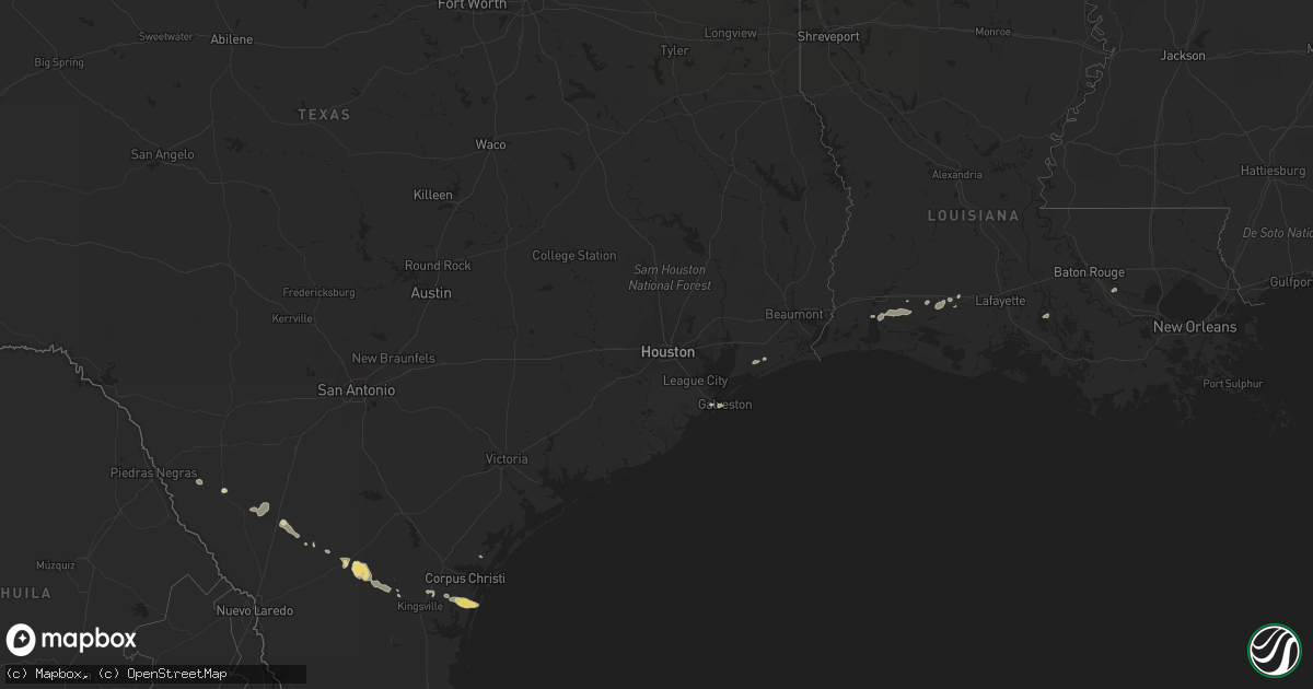
Hail Map in Louisiana on March 5, 2011
Get this storm
March 5 map
$229
one time, instant access
Download today. No call, no setup
Keep the $229
Bought the map and want the full workflow? Apply the entire $229 to a subscription within 7 days. None of it is wasted.
Every map, not just this one
This buys you this map. Subscription and you get every map we run, in the markets you choose from a few cities to whole states to nationwide. Plus real-time alerts the moment a storm fires.
Contact data
Name, contact info, occupancy, even credit band for addresses in the footprint. You go from where it hit to who to call.
Become the source they trust
Unlimited branding weather history reports on demand. You already have the documented answer ready for the property owner, and you are the one who showed up with it.
Property data and RoofTrace estimates
Pull up any address you have got, its value and the exact code rules for that jurisdiction, straight from One Click Code. Then RoofTrace estimates the squares, pitch, and roof value, priced the way you price.
Storm reports in Louisiana
Louisiana
| Date | Description |
|---|---|
| 03/05/20111:40 PM CST | Emergency manager reported damage at the corner of ames and fourth. Power lines down...roof damage to a business with debris thrown about and standing water on streets |
| 03/05/20111:30 PM CST | Roof damage to trailers in the lafitte area reported by emergency management and fire department. Possible tornado. Time of event estimated by radar. |
| 03/05/20111:30 PM CST | Public reported minor street flooding...wind gusts estimated near 55 miles per hour and small tree limbs down in the terrytown area. |
| 03/05/20111:29 PM CST | Emergency manager reported damage at the corner of ames and fourth. Power lines down...roof damage to a business with debris thrown about and standing water on streets |
| 03/05/20111:29 PM CST | Emergency manager reported damage at the corner of ames and fourth. Power lines down...roof damage to a business with debris thrown about and standing water on streets |
| 03/05/20111:00 PM CST | Houma newspaper reported a service trailer blown over in motegut. |
| 03/05/201112:50 PM CST | Lafourche parish emergency manager reported wind damage associated with a possible tornado including a destroyed trailer...trees snapped...shingles blown off a roof and |
| 03/05/201112:40 PM CST | Residence with extensive damage in baker. Reported by local media with pictures sent to wfo. |
| 03/05/201112:32 PM CST | Nws storm survey confirmed weak ef1 tornado. Approximately one half mile long and 30 yards wide. Several houses roof damage windows blown in...mobile home heavily damag |
| 03/05/201112:31 PM CST | Power lines reported down in schriever...possible tornado. |
| 03/05/201112:30 PM CST | Rain wrapped tornado south of antioch and tiger bend roads in shenandoah subdivision near east baton rouge parish and ascension parish line. |
| 03/05/201112:30 PM CST | Ascension parish emergency manager reported several trees down in the galvez area. Time estimated by radar. |
| 03/05/201112:30 PM CST | Ascension parish emergency manager reported several trees down in the galvez area. Time estimated by radar. |
| 03/05/201112:27 PM CST | Possible tornado reported on taylor road just off of south satsuma road. Damage occurred to one residence. |
| 03/05/201112:27 PM CST | Weak tornado touched down removing significant portion of roof and exterior wall. Large tree limbs snapped. Sheet metal wrapped in trees. Damage path 0.2 miles width 25 |
| 03/05/201112:23 PM CST | Tree damage blocking highway 42 near port vincent. Picture forwarded to wfo by broadcast media. Possible tornado. |
| 03/05/201112:22 PM CST | Rain wrapped tornado south of antioch and tiger bend roads near east baton rouge parish and ascension parish line. |
| 03/05/201112:20 PM CST | House roof partially removed along with portion of back wall. Outbuildings and shed heavily damaged. Large tree knocked over. Large tree limbs snapped. Insulation and t |
| 03/05/201112:20 PM CST | 59 mph gust measured by the lsu ag station at ben hur. |
| 03/05/201112:20 PM CST | 59 mph gust measured by the lsu ag station at ben hur. |
| 03/05/201112:16 PM CST | Ascension parish emergency manager reported several trees down in the gonzales area. |
| 03/05/201112:16 PM CST | *** 1 inj *** ascension parish emergenecy manager reported a tree downed on a vehicle near the intersection of highway 44 and highway 941. Time estimated by radar. |
| 03/05/201112:13 PM CST | Public reported that their trampoline was picked up above the roof line of their home and tossed into another yard. Tree limbs also reported downed. |
| 03/05/201112:13 PM CST | *** 1 inj *** ascension parish emergency manager reported a tree downed on a vehicle near the intersection of highway 44 and highway 941. Time estimated by radar. |
| 03/05/201112:04 PM CST | Iberville parish emergency manager reported roof damage to a residence on highway 405 just east of plaquemine. |
| 03/05/201110:00 AM CST | Building damge reported by lafayette skywarn spotter network in rayne. Possible tornado. |
| 03/05/20119:44 AM CST | *** 3 inj *** nws storm survey confirms an ef 0 tornado touchdown. The tornado was 25 yards wide and produced a damage path two miles long. 3 injuries were confirmed in |
| 03/05/20119:30 AM CST | *** 3 inj *** katc reports moderate building damage near a waffle house along hwy 100 and 13 just north of i-10. Additional damage includes two ruptured gas lines. Katc |
| 03/05/20118:51 AM CST | Ef0 tornado began southwest of lyons rd and mouton rd intersection and ended northwest of hwy 26 and bobby rd. Several power poles were knocked down along mouton rd and |
| 03/05/20118:40 AM CST | Ef0 tornado began northeast of hwy 99 and marceaux rd intersection and ended east of hwy 382. Several farm buildings were damaged along hwy 382 with sheet metal blown a |
Cities Impacted by Hail Map on March 5, 2011
- Galveston, TX
- Iowa, LA
- Asherton, TX
- Saint Martinville, LA
- Jennings, LA
- Welsh, LA
- Freer, TX
- San Diego, TX
- Concepcion, TX
- Rio Grande City, TX
- Anahuac, TX
- Alice, TX
- Carrizo Springs, TX
- Encinal, TX
- Robstown, TX
- Bishop, TX
- Corpus Christi, TX
- Laredo, TX
- Crowley, LA
- Stamps, AR
- Buckner, AR
- Lewisville, AR
- Morse, LA
- Mermentau, LA
- Winnie, TX
- Saint Amant, LA
- Gonzales, LA
- Prairieville, LA
- Mission, TX
- Lake Charles, LA
- Bell City, LA
- Egan, LA
- Aransas Pass, TX
- Portland, TX


