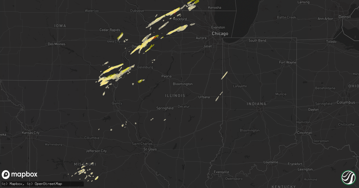
Hail Map in Illinois on March 4, 2024
Get this storm
March 4 map
$229
one time, instant access
Download today. No call, no setup
Keep the $229
Bought the map and want the full workflow? Apply the entire $229 to a subscription within 7 days. None of it is wasted.
Every map, not just this one
This buys you this map. Subscription and you get every map we run, in the markets you choose from a few cities to whole states to nationwide. Plus real-time alerts the moment a storm fires.
Contact data
Name, contact info, occupancy, even credit band for addresses in the footprint. You go from where it hit to who to call.
Become the source they trust
Unlimited branding weather history reports on demand. You already have the documented answer ready for the property owner, and you are the one who showed up with it.
Property data and RoofTrace estimates
Pull up any address you have got, its value and the exact code rules for that jurisdiction, straight from One Click Code. Then RoofTrace estimates the squares, pitch, and roof value, priced the way you price.
Storm reports in Illinois
Illinois
| Date | Description |
|---|---|
| 03/04/20244:48 PM CST | Trained spotter reports quarter sized hail on the north side of dixon. |
| 03/04/20244:15 PM CST | Report from mping: quarter |
| 03/04/20244:15 PM CST | Delayed report via social media. |
| 03/04/20244:12 PM CST | Delayed report via social media picture. |
| 03/04/20243:05 PM CST | A local report indicates 1.00 inch wind near Lanark |
| 03/04/20243:05 PM CST | Delayed report via social media. Lasted 10 minutes. |
| 03/04/20243:00 PM CST | Extensive quarter sized hail had virtually stopped traffic along i-80 west of geneseo. Estimated around mm15 around 3 pm. Time based on radar. |
| 03/04/20243:00 PM CST | Extensive quarter sized hail had virtually stopped traffic along i-80 w |
| 03/04/20241:29 PM CST | Delayed report... Near intersection of zion rd and elizabeth rd... Time estimated from radar. |
| 03/04/20242:39 AM CST | A local report indicates 1.00 inch wind near 3 E Danville |
| 03/03/20249:23 PM CST | A local report indicates 1.00 inch wind near 1 SE La Grange |
| 03/03/20248:32 PM CST | Relayed by nws lincoln. |
| 03/03/20248:04 PM CST | 4 to 5 inch tree limbs down. Also... Dime size hail. |
| 03/03/20246:03 PM CST | Quarter sized hail reported southwest of kirkland. Some melting had occurred prior to observation. Time estimated by radar. |
All States Impacted by Hail Map on March 4, 2024
Cities Impacted by Hail Map on March 4, 2024
- Port Sulphur, LA
- Pollock, LA
- Georgetown, LA
- Mount Carroll, IL
- Elizabeth, IL
- Stockton, IL
- Pearl City, IL
- Monroe, LA
- Lena, IL
- Freeport, IL
- Cedarville, IL
- Dakota, IL
- Strong, AR
- Huttig, AR
- Rock City, IL
- Davis, IL
- Durand, IL
- Hermitage, AR
- Bettendorf, IA
- Brodhead, WI
- Beloit, WI
- Sterlington, LA
- Bastrop, LA
- Jersey, AR
- Banks, AR
- Warren, AR
- Orion, IL
- Osco, IL
- Geneseo, IL
- Trout, LA
- Tullos, LA
- Olla, LA
- Prophetstown, IL
- Kelly, LA
- Grayson, LA
- Columbia, LA
- Taylor Ridge, IL
- Illinois City, IL
- Reynolds, IL
- Keosauqua, IA
- Stockport, IA
- Hillsboro, IA
- Salem, IA
- Mount Pleasant, IA
- Bernice, LA
- Andalusia, IL
- Spearsville, LA
- Milan, IL
- Arbela, MO
- Luray, MO
- Mount Sterling, IA
- Farmington, IA
- Bonaparte, IA
- Kahoka, MO
- Donnellson, IA
- Lillie, LA
- Buffalo, IA
- Blue Grass, IA
- Davenport, IA
- New London, IA
- Rock Island, IL
- West Point, IA
- Moline, IL
- East Moline, IL
- Le Claire, IA
- Port Byron, IL
- Cordova, IL
- Hillsdale, IL
- Albany, IL
- Erie, IL
- Fulton, IL
- Fenton, IL
- Pickens, AR
- Whitewater, WI
- Avalon, WI
- Delavan, WI
- Tillar, AR
- Elkhorn, WI
- East Troy, WI
- Morrison, IL
- Dumas, AR
- Hampton, AR
- Louann, AR
- Princeton, IA
- Sherrard, IL
- Lynn Center, IL
- Shannon, IL
- Silvis, IL
- El Dorado, AR
- Marrero, LA
- Milledgeville, IL
- Lanark, IL
- Forreston, IL
- Chadwick, IL
- Bonita, LA
- Jones, LA
- Hamburg, AR
- Montrose, AR
- Rockton, IL
- Lake Village, AR
- Collinston, LA
- Pecatonica, IL
- Dermott, AR
- Lafitte, LA
- Braithwaite, LA
- Savanna, IL
- Sabula, IA
- Long Grove, IA
- Camanche, IA
- Eldridge, IA
- Chatham, LA
- La Place, LA
- Coal Valley, IL
- Pleasant Valley, IA
- Janesville, WI
- Miles, IA
- Lettsworth, LA
- Simmesport, LA
- Moreauville, LA
- Farmerville, LA
- West Monroe, LA
- Marion, LA
- Oak Ridge, LA
- Jonesville, LA
- Pineville, LA
- Dry Prong, LA
- Clinton, IA
- Hampton, IL
- Carbon Cliff, IL
- Athens, LA
- Dubberly, LA
- Rapids City, IL
- Yarmouth, IA
- Mount Union, IA
- Morning Sun, IA
- Mediapolis, IA
- Dixon, IL
- Oregon, IL
- Pine Bluff, AR
- Grady, AR
- Altheimer, AR
- Sterling, IL
- Rock Falls, IL
- Burlington, WI
- Meraux, LA
- Violet, LA
- New Orleans, LA
- Gillett, AR
- Chana, IL
- Ashton, IL
- Franklin Grove, IL
- Rochelle, IL
- Davis Junction, IL
- Holcomb, IL
- West Burlington, IA
- Burlington, IA
- De Witt, AR
- Humphrey, AR
- Wabbaseka, AR
- Humnoke, AR
- Esmond, IL
- Kirkland, IL
- Poplar Bluff, MO
- Harrisburg, AR
- Trumann, AR
- Bay, AR
- Jonesboro, AR
- Bushnell, IL
- Good Hope, IL
- Prairie City, IL
- Macomb, IL
- Iowa City, IA
- West Branch, IA
- Solon, IA
- Tipton, IA
- Mechanicsville, IA
- Rockford, IL
- Harrell, AR
- Saint Patrick, MO
- Carlisle, AR
- Darien, WI
- Machesney Park, IL
- Sharon, WI
- Zalma, MO
- Sturdivant, MO
- Batesville, AR
- Cave City, AR
- Ridott, IL
- Franklin, WI
- Genoa, IL
- Hampshire, IL
- Winnebago, IL
- Wever, IA
- Fort Madison, IA
- Denmark, IA
- Bloomfield, MO
- Puxico, MO
- Dudley, MO
- Cantril, IA
- Carthage, AR
- Searcy, AR
- Junction City, AR
- Malta, IL
- Lindenwood, IL
- Monroe Center, IL
- Clare, IL
- Kingston, IL
- Beebe, AR
- Wheatley, AR
- Brinkley, AR
- Cotton Plant, AR
- Muskego, WI
- Montrose, IA
- England, AR
- Bluffton, TX
- Buchanan Dam, TX
- Clarendon, AR
- Bennett, IA
- Casscoe, AR
- Holly Grove, AR
- Stuttgart, AR
- Roe, AR
- Goodwin, AR
- Moro, AR
- Hazen, AR
- Gladstone, IL
- Danville, IA
- Middletown, IA
- Memphis, MO
- Oquawka, IL
- Little York, IL
- Monmouth, IL
- Carman, IL
- Seaton, IL
- Sperry, IA
- Milwaukee, WI
- Clinton, WI
- Williams Bay, WI
- Walworth, WI
- Capron, IL
- Lake Geneva, WI
- Stronghurst, IL
- Baileyville, IL
- German Valley, IL
- Birmingham, IA
- Gould, AR
- Cherry Valley, AR
- Leola, AR
- Saint Bernard, LA
- Oil Trough, AR
- Clinton, AR
- Watson, AR
- Winchester, AR
- Marked Tree, AR
- Moscow, IA
- Atalissa, IA
- Muscatine, IA
- Wynne, AR
- Parkin, AR
- Forrest City, AR
- Widener, AR
- Weiner, AR
- Brookland, AR
- Heth, AR
- Magnolia, AR
- Emerson, AR
- McRae, AR
- Wayland, MO
- New Berlin, WI
- Paragould, AR
- Sparkman, AR
- Joy, IL
- Hales Corners, WI
- Newport, AR
- Tichnor, AR
- Crocketts Bluff, AR
- Lockridge, IA
- Graff, MO
- Cabool, MO
- Hico, TX
- Iredell, TX
- Marble Hill, MO
- Nashville, AR
- Dierks, AR
- Ava, MO
- Hermitage, MO
- Preston, MO
- Laddonia, MO
- Witts Springs, AR
- Glenallen, MO
- Louisiana, MO
- Bowling Green, MO
- Waynesville, MO
- Saint Robert, MO
- Fort Leonard Wood, MO
- Fairfield, IA
- Brighton, IA
- Mount Judea, AR
- Neelyville, MO
- Scotland, AR
- Avon, IL
- La Belle, MO
- Mountain Grove, MO
- Patton, MO
- Murfreesboro, AR
- Kirby, AR
- Stanwood, IA
- Nebo, IL
- Colchester, IL
- Galva, IL
- Amity, AR
- Altona, IL
- Langley, AR
- Delight, AR
- Newhope, AR
- Glenwood, AR
- Umpire, AR
- Centralia, MO
- Victoria, IL
- Deer, AR
- Marshall, AR
- Buras, LA
- Powell, TX
- Corsicana, TX
- Kerens, TX
- Trinidad, TX
- Malakoff, TX
- Athens, TX
- Mabank, TX
- Eustace, TX
- Palestine, TX
- Frankston, TX
- Larue, TX
- Chandler, TX
- Flint, TX
- Bullard, TX
- Tyler, TX
- Farmersville, IL
- Chester, AR
- Cedarville, AR
- Rudy, AR
- Camdenton, MO
- Milford, IL
- Earl Park, IN
- Coushatta, LA
- Hemphill, TX
- Kaufman, TX
- Wills Point, TX
- Grapeland, TX
- Jacksonville, TX
- Oakwood, TX
- Buffalo, TX
- Stoutland, MO
- Mansfield, LA
- Shirley, AR
- Richland, MO
- Leslie, AR
- Tilly, AR
- Carthage, TX
- Terrell, TX
- Montreal, MO
- Saint Elizabeth, MO
- Iberia, MO
- Tuscumbia, MO
- Grand Cane, LA
- Logansport, LA
- Quinlan, TX
- Greenville, TX
- Lone Oak, TX
- Hector, AR
- Dennard, AR
- Jerusalem, AR
- Pelsor, AR
- Hagarville, AR
- Alto, TX
- Kentland, IN
- Lewisville, AR
- Taylor, AR
- Chireno, TX
- Huntington, TX
- Etoile, TX
- Linn Creek, MO
- Mountainburg, AR
- Ozark, AR
- Van Buren, AR
- Center, TX
- Jessieville, AR
- Hot Springs Village, AR
- Springhill, LA
- Arp, TX
- Troup, TX
- Henderson, TX
- Overton, TX
- Uniontown, AR
- Natural Dam, AR
- Russellville, MO
- Pettigrew, AR
- Rice, TX
- Shreveport, LA
- Middletown, MO
- Bismarck, IL
- West Lebanon, IN
- Bronson, TX
- Danville, IL
- Fairmount, IL
- Catlin, IL
- Alma, IL
- Osage Beach, MO
- Kaiser, MO
- Groveton, TX
- Tuskahoma, OK
- San Augustine, TX
- Crockett, TX
- Pittsburg, TX
- Muldrow, OK
- Roodhouse, IL
- Palmyra, IL
- Florien, LA
- Crocker, MO
- Ringgold, LA
- Tunas, MO
- Urbana, MO
- Clarksville, AR
- Hartman, AR
- Cookson, OK
- Bradley, AR
- Lufkin, TX
- Paris, AR
- Modesto, IL
- Lebanon, MO
- Arkadelphia, AR
- Winslow, AR
- Many, LA
- Dodson, LA
- Park Hill, OK
- Vian, OK
- Brumley, MO
- Whitehouse, TX
- Streetman, TX
- Fairfield, TX
- Campbell, TX
- Selman City, TX
- Sulphur Springs, TX
- Lake Ozark, MO
- Sunrise Beach, MO
- Tennessee Colony, TX
- Eldridge, MO
- Rusk, TX
- Point, TX
- Como, TX
- Macks Creek, MO
- Roach, MO
- Roland, OK
- Bryant, IA
- Goodland, IN


