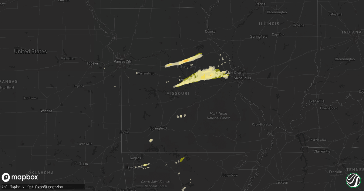
Hail Map in Missouri on March 4, 2011
Get this storm
March 4 map
$229
one time, instant access
Download today. No call, no setup
Keep the $229
Bought the map and want the full workflow? Apply the entire $229 to a subscription within 7 days. None of it is wasted.
Every map, not just this one
This buys you this map. Subscription and you get every map we run, in the markets you choose from a few cities to whole states to nationwide. Plus real-time alerts the moment a storm fires.
Contact data
Name, contact info, occupancy, even credit band for addresses in the footprint. You go from where it hit to who to call.
Become the source they trust
Unlimited branding weather history reports on demand. You already have the documented answer ready for the property owner, and you are the one who showed up with it.
Property data and RoofTrace estimates
Pull up any address you have got, its value and the exact code rules for that jurisdiction, straight from One Click Code. Then RoofTrace estimates the squares, pitch, and roof value, priced the way you price.
Storm reports in Missouri
Missouri
| Date | Description |
|---|---|
| 03/04/20115:20 PM CST | Hail between three quarter inch and one inch in diameter. |
| 03/04/20114:46 PM CST | Trees down |
| 03/04/20114:03 PM CST | A local report indicates 78 MPH wind near 4 E PORTLAND |
| 03/04/20113:43 PM CST | A local report indicates 1.00 inch wind near 1 E JEFFERSON CITY |
| 03/04/20113:40 PM CST | Several locations along hwy c between jefferson city and russelville |
| 03/04/20113:40 PM CST | Pea sized hail covering the ground...possible wall cloud with rotation |
| 03/04/20113:35 PM CST | On hwy 124 just south of town |
| 03/04/20113:33 PM CST | Shingles blown off house and into trees...also pea sized hail |
| 03/04/20113:30 PM CST | Minor roof damage and a report of trees across a road |
| 03/04/20113:30 PM CST | A local report indicates 64 MPH wind near 4 NNE ASHLAND |
| 03/04/20113:20 PM CST | Utility poles down on hwy 124 north somewhere between centralia and hallsville |
| 03/04/20113:16 PM CST | A local report indicates 1.75 inch wind near HALLSVILLE |
All States Impacted by Hail Map on March 4, 2011
Cities Impacted by Hail Map on March 4, 2011
- Lawrence, KS
- Huntsville, AR
- Russellville, MO
- Lohman, MO
- Jefferson City, MO
- Eldon, MO
- Columbia, MO
- Auxvasse, MO
- Mayflower, AR
- Lebanon, MO
- Falcon, MO
- Foristell, MO
- Defiance, MO
- Augusta, MO
- Laquey, MO
- Lynchburg, MO
- Crane, MO
- Galena, MO
- Cookville, TX
- Omaha, TX
- Mount Pleasant, TX
- Hermann, MO
- Rush Hill, MO
- Sturgeon, MO
- Rocheport, MO
- Franklin, MO
- Centralia, MO
- Blackwater, MO
- Fayette, MO
- Hallsville, MO
- Mexico, MO
- Thompson, MO
- Harrisburg, MO
- New Franklin, MO
- Laddonia, MO
- Olean, MO
- Troy, MO
- Fulton, MO
- New Bloomfield, MO
- Jonesburg, MO
- Portland, MO
- Mokane, MO
- Williamsburg, MO
- Holts Summit, MO
- High Hill, MO
- Morrison, MO
- Berger, MO
- Wright City, MO
- Chamois, MO
- Tebbetts, MO
- Steedman, MO
- Marthasville, MO
- New Florence, MO
- Warrenton, MO
- Rhineland, MO
- New Haven, MO
- Montgomery City, MO
- Bonnots Mill, MO
- Linn, MO
- Eugene, MO
- Greenbrier, AR
- Kingsville, MO
- Mcalister, NM
- Wentzville, MO
- Foley, MO
- Eolia, MO
- Uvalde, TX
- Hawk Point, MO
- Leslie, AR
- Damascus, AR
- Conway, AR
- Sherwood, AR
- Versailles, MO
- Stover, MO
- California, MO
- Barnett, MO
- Aurora, MO
- Quitman, AR
- Bee Branch, AR
- Springfield, AR
- Elkins, AR
- Lake Saint Louis, MO
- Harrison, AR
- Everton, AR
- Western Grove, AR
- Covington, LA
- Harrisonville, MO
- Truesdale, MO
- Truxton, MO
- Eagle Pass, TX
- O'Fallon, MO
- Saint Peters, MO
- Saint Charles, MO
- Fayetteville, AR
- Grovespring, MO
- Boonville, MO
- Nelson, MO
- Grady, NM
- Silex, MO
- Elsberry, MO
- Nash, TX
- Texarkana, TX
- Edgemont, AR
- Higden, AR
- Solgohachia, AR
- Wesley, AR
- Batchtown, IL
- Clarksville, MO
- Garnett, KS
- Kingdom City, MO
- Louisburg, KS
- Hindsville, AR
- Flippin, AR
- Mountain View, AR
- Prim, AR
- Fontana, KS
- Jacksonville, AR
- Yellville, AR
- Fouke, AR
- Doddridge, AR
- Hartsburg, MO
- Mountain Home, AR
- Gassville, AR


