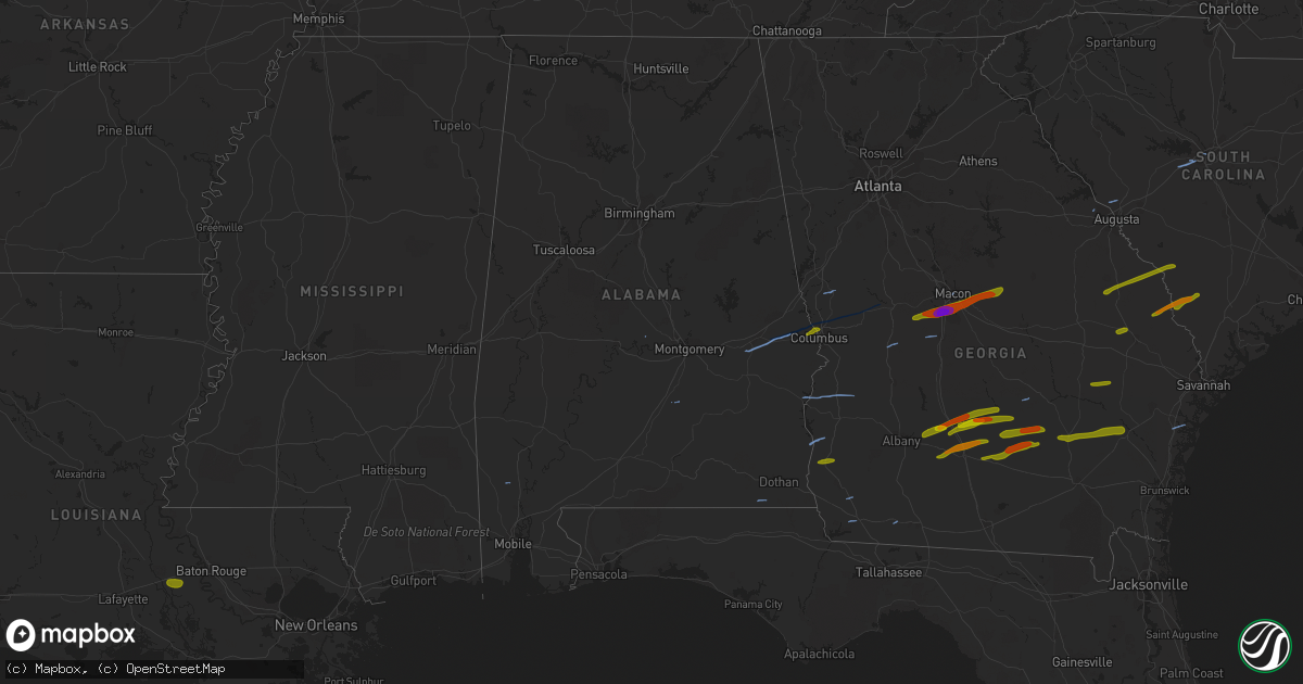
Hail Map in Alabama on March 3, 2019
Get this storm
March 3 map
$229
one time, instant access
Download today. No call, no setup
Keep the $229
Bought the map and want the full workflow? Apply the entire $229 to a subscription within 7 days. None of it is wasted.
Every map, not just this one
This buys you this map. Subscription and you get every map we run, in the markets you choose from a few cities to whole states to nationwide. Plus real-time alerts the moment a storm fires.
Contact data
Name, contact info, occupancy, even credit band for addresses in the footprint. You go from where it hit to who to call.
Become the source they trust
Unlimited branding weather history reports on demand. You already have the documented answer ready for the property owner, and you are the one who showed up with it.
Property data and RoofTrace estimates
Pull up any address you have got, its value and the exact code rules for that jurisdiction, straight from One Click Code. Then RoofTrace estimates the squares, pitch, and roof value, priced the way you price.
Storm reports in Alabama
Alabama
| Date | Description |
|---|---|
| 03/03/20195:30 PM CST | Trees down near 10808 east county road 8. |
| 03/03/20195:13 PM CST | Power pole down on hartford street in dale county. |
| 03/03/20195:05 PM CST | A small shed collapsed with some of the tin strewn across the road. |
| 03/03/20195:03 PM CST | Tree fell on a home. |
| 03/03/20194:55 PM CST | Multiple trees and powerlines down with trees on houses reported. |
| 03/03/20194:53 PM CST | Numerous trees and power lines down between slocomb and fadette. Dual-pol tornadic debris signature in the same area. |
| 03/03/20194:26 PM CST | Corrects previous tstm wnd dmg report from 1 se newton. Power pole down on hartford street in dale county. Corrected time of event. |
| 03/03/20194:02 PM CST | Confirmed tornado at weedon field in eufaula. Damage to fire department. |
| 03/03/20193:58 PM CST | A tornado touched down 4 miles north of eufaula... Moved northeast... Crossed cr 97 strengthening slightly before entering the weedon field complex where the most exten |
| 03/03/20193:45 PM CST | A tornado touched down near mary c smith road... Moved eastward... Crossed cr 79... And reverend crawford road. Numerous trees were snapped and uprooted with trees comp |
| 03/03/20193:35 PM CST | Several trees down along open pond rd with one falling on a car. Time estimated by radar. |
| 03/03/20193:20 PM CST | Bullock county ema reports numerous trees down near the blues stand and perote communities. Time estimated by radar. Possible tornado damage. |
| 03/03/20193:18 PM CST | Rfd winds from the same storm that produced a weak tornado a few miles to the northwest caused damage along us hwy 29. Several trees were uprooted and many branches bro |
| 03/03/20193:15 PM CST | A weak tornado touched down 5 miles west northwest of perote... Tracked east across cr 27 and crossed cr 8 where it eventually lifted. Trees were uprooted and large bra |
| 03/03/20193:00 PM CST | Structural damage along 280 between opelika and phenix city. |
| 03/03/20192:52 PM CST | Damage to mobile homes with trees and power lines down. |
| 03/03/20192:51 PM CST | Multiple trees and power lines down along cr100. |
| 03/03/20192:43 PM CST | Several trees and treetops down nw of atmore... Al along jack springs rd. Time estimated by radar. |
| 03/03/20192:40 PM CST | Damage reported to trees and structures near the vicinity of white road. Possible tornado. Time estimated from radar. |
| 03/03/20192:39 PM CST | Damage reported to trees and structures near the vicinity of bowden road. Possible tornado. Time estimated from radar. |
| 03/03/20192:38 PM CST | Storm survey team found numerous trees snapped and damage to outbuildings consistent with ef-1 strength. Time estimated by radar. |
| 03/03/20192:35 PM CST | Damage reported to homes and multiple trees down near steiner store road and spring creek rd northeast of greenville... Al. Possible tornado. Time estimated by radar. |
| 03/03/20192:34 PM CST | Corrects previous tstm wnd dmg report from 6 nnw honoraville to tornado. Damage reported to homes and multiple trees down near steiner store road and spring creek rd no |
| 03/03/20192:30 PM CST | Multiple trees down across lee county rd 240 west of smiths station. |
| 03/03/20192:27 PM CST | *** 1 inj *** a weak tornado touched down 4 miles south of tuskegee... Tracked northeast... Strengthened near us hwy 29... Continued across us hwy 80 into lee county an |
| 03/03/20192:25 PM CST | Damage along hwy 280 near smith station. |
| 03/03/20192:22 PM CST | Corrects previous tornado report from salem. Us hwy 280 blocked by downed cell tower across hwy. |
| 03/03/20192:22 PM CST | Us hwy 280 blocked by downed cell tower across hwy. |
| 03/03/20192:20 PM CST | Trees down near us 80 south of tuskegee. |
| 03/03/20192:20 PM CST | Corrects previous tornado report from 1 sw tuskegee. Trees down near us 80 south of tuskegee. |
| 03/03/20192:09 PM CST | Trees and power lines down near the intersection 401 and 175 near crawford...al. |
| 03/03/20192:03 PM CST | Confirmed damage near dupree... Al. Multiple homes damaged. Tornado confirmed by radar. |
| 03/03/20192:00 PM CST | *** 23 fatal... 90 inj *** a tornado touched down in eastern macon county and quickly intensified as it moved into lee county... To an ef4... With winds of 170 mph. Dev |
| 03/03/20191:45 PM CST | Tree blocking road at walker springs road near overstreet grocery. |
| 03/03/20191:39 PM CST | Public reported 1 inch hail near sims chapel... Al. Time estimated by radar. |
| 03/03/20191:39 PM CST | Significant damage to a church and one mobile home reported as well as several trees down along fairford rd in sims chapel... Al. Time estimated by radar. |
| 03/03/20191:37 PM CST | The tornado began near john johnston road and continued east... Adjacent to fairford road. The tornado lifted roughly just south of price rivers road and just east of f |
| 03/03/20191:27 PM CST | Trees down along cr 45 nw of autaugaville. |
| 03/03/20191:25 PM CST | Trees down along cr 19 north of autaugaville. |
| 03/03/20191:19 PM CST | A tornado touched 6 miles northwest of autaugaville and tracked northeast towards cr 33. Several trees were uprooted and snapped along cr 33. The tornado turned north.. |
| 03/03/201912:57 PM CST | Storm spotter reports several trees and powerlines down across hwy 17 five miles south of chatom... Al. Possible tornado damage. Time estimated by radar. |
| 03/03/201912:55 PM CST | The tornado touched down just west of highway 17... 3 miles south of chatom. The tornado crossed highway 17 and continued east into a more forested area. The path lengt |
| 03/03/20196:23 AM CST | At 1223 PM CST, severe thunderstorms were located along a line extending from 6 miles northeast of Millry to 7 miles west of State Line to 4 miles northwest of New Augusta, moving east at 55 mph. HAZARD...60 mph wind gusts and penny size hail. SOURCE...Radar indicated. IMPACT...Expect damage to roofs, siding, and trees. Locations impacted include... Jackson, Grove Hill, Chatom, Richton, Leakesville, Saint Stephens, Wagarville, Leroy, Deer Park, Whatley, Tibbie, New Augusta, Millry, State Line, Buckatunna, Fruitdale, Coffeeville and Fulton. |
| 03/03/20196:04 AM CST | At 1203 PM CST, a severe thunderstorm was located near De Funiak Springs, moving northeast at 35 mph. HAZARD...60 mph wind gusts and quarter size hail. SOURCE...Radar indicated. IMPACT...Hail damage to vehicles is expected. Expect wind damage to roofs, siding, and trees. Locations impacted include... De Funiak Springs, Eglin Air Force Base, Union, Liberty, Gordon, Oakwood Hills, Cluster Springs, Fox Hill, Leonia, Sand Hill, Alpine Heights, Darlington, Glendale, Pleasant Hill, Center Ridge, New Harmony, Piney Grove and Caney Creek. |
| 03/03/20195:52 AM CST | At 1152 AM CST, severe thunderstorms were located along a line extending from 3 miles north of Clara to Hattiesburg, moving east at 55 mph. HAZARD...60 mph wind gusts and penny size hail. SOURCE...Radar indicated. IMPACT...Expect damage to roofs, siding, and trees. Locations impacted include... Waynesboro, Chatom, Richton, Clara, New Augusta, Millry, State Line, Buckatunna and Fruitdale. |
| 03/03/20195:05 AM CST | At 1105 AM CST, a severe thunderstorm was located near Goodwater, or 11 miles southwest of Quitman, moving east at 60 mph. HAZARD...60 mph wind gusts. SOURCE...Radar indicated. IMPACT...Expect damage to roofs, siding, and trees. This severe thunderstorm will be near... De Soto around 1110 AM CST. Crandall around 1125 AM CST.Other locations impacted by this severe thunderstorm include Shubuta. |
| 03/03/201912:27 AM CST | At 627 PM EST/527 PM CST/, severe thunderstorms were located along a line extending from near Arabi to 11 miles west of Donalsonville, moving east at 60 mph. HAZARD...60 mph wind gusts. SOURCE...Radar indicated. IMPACT...Expect damage to roofs, siding, and trees. Locations impacted include... Colquitt, Newton, Morgan, Albany, Dawson, Pelham, Putney, Donalsonville, Leesburg, Camilla, Arlington, Baconton, Leary, Smithville, East Albany, Marine Corps Logistics Base, Turner City, Walker, Douglasville and Centerville. |
| 03/02/201911:11 PM CST | At 511 PM EST/411 PM CST/, severe thunderstorms were located along a line extending from near Lumpkin to near Abbeville, moving east at 45 mph. HAZARD...60 mph wind gusts. SOURCE...Radar indicated. IMPACT...Expect damage to roofs, siding, and trees. Locations impacted include... Fort Gaines, Georgetown, Dawson, Cuthbert, Edison, Shellman, Smithville, Bronwood, Parrott, Bellville, Bluffton, Wire Bridge, Parksville, Carnegie, Watson Crossroads, Scottsboro Crossroads, Ricks Place, Pecan, Thomas Mill Creek and Chambliss. |
| 03/02/201910:37 PM CST | At 437 PM CST, severe thunderstorms were located along a line extending from 9 miles south of Hartford to near Destin, moving east at 45 mph. HAZARD...60 mph wind gusts. SOURCE...Radar indicated. IMPACT...Expect damage to roofs, siding, and trees. Locations impacted include... Vernon, Chipley, Graceville, Santa Rosa Beach, Bonifay, De Funiak Springs, Eglin Air Force Base, Bradford, Live Oak, Malone, Freeport, Cottondale, Greenwood, Ponce De Leon, Caryville, Wausau, Esto, Westville, Ebro and Campbellton. |
| 03/02/201910:04 PM CST | At 403 PM CST, severe thunderstorms were located along a line extending from near Geneva to 6 miles north of Wright, moving east at 40 mph. HAZARD...60 mph wind gusts. SOURCE...Radar indicated. IMPACT...Expect damage to roofs, siding, and trees. Locations impacted include... De Funiak Springs, Geneva, Santa Rosa Beach, Samson, Eglin Air Force Base, Union, Liberty, Freeport, Ponce De Leon, Caryville, Westville, Black, Oakwood Hills, Cluster Springs, Villa Tasso, Cerrogordo, Gritney, Logan Field Municipal A/P, Rock Hill and Glendale. |
| 03/02/20199:37 PM CST | At 337 PM CST, severe thunderstorms were located along a line extending from 8 miles northwest of Samson to 11 miles east of Roeville, moving east at 35 mph. HAZARD...60 mph wind gusts and nickel size hail. SOURCE...Radar indicated. IMPACT...Expect damage to roofs, siding, and trees. Locations impacted include... Geneva, Samson, Eglin Air Force Base, Liberty, Paxton, Coffee Springs, Pond Creek, Oakwood Hills, Cluster Springs, Gaskin, Alpine Heights, Lytle, Darlington, Marl, Logan Field Municipal A/P, Geneva Municipal A/P, Glendale, New Harmony, Piney Grove and Somerset. |
| 03/02/20199:29 PM CST | At 329 PM CST, a severe thunderstorm was located 7 miles southwest of River Falls, or 8 miles west of Andalusia, moving east at 55 mph. HAZARD...60 mph wind gusts and penny size hail. SOURCE...Radar indicated. IMPACT...Expect damage to roofs, siding, and trees. Locations impacted include... Andalusia, Opp, River Falls and Heath. |
| 03/02/20199:25 PM CST | At 325 PM CST, a severe thunderstorm was located 6 miles northwest of Baker, or 12 miles northwest of Crestview, moving east at 55 mph. HAZARD...60 mph wind gusts and nickel size hail. SOURCE...Radar indicated. IMPACT...Expect damage to roofs, siding, and trees. Locations impacted include... Baker and Laurel Hill. |
| 03/02/20199:12 PM CST | At 312 PM CST, severe thunderstorms were located along a line extending from near Banks to 10 miles southwest of Red Level, moving southeast at 30 mph. HAZARD...60 mph wind gusts and nickel size hail. SOURCE...Radar indicated. IMPACT...Expect damage to roofs, siding, and trees. Locations impacted include... Elba, Fort Rucker, New Brockton, Ariton, Lee, Kinston, Pine Level, Mixons Crossroads, Perry Store, Curtis, Carl Folsom A/p, Ino, Lowry Mill, Camp Humming Hills, Clintonville, Wise Mill, Roeton, Clowers Crossroads, Basin and Phillips Crossroads. |
| 03/02/20199:04 PM CST | At 304 PM CST, a severe thunderstorm was located 9 miles north of Point Baker, or 13 miles north of Milton, moving east at 50 mph. HAZARD...60 mph wind gusts and nickel size hail. SOURCE...Radar indicated. IMPACT...Expect damage to roofs, siding, and trees. Locations impacted include... Baker. |
| 03/02/20198:38 PM CST | At 238 PM CST, a severe thunderstorm was located near I65 And AL 113, or 13 miles south of Frisco City, moving east at 50 mph. HAZARD...60 mph wind gusts and nickel size hail. SOURCE...Radar indicated. IMPACT...Expect damage to roofs, siding, and trees. Locations impacted include... Atmore, Brewton, Flomaton, McCullough, East Brewton, Castleberry, Pollard, Riverview, I65 And CR 1, I65 And AL 113, I65 And AL 21 and Poarch Creek Reservation. |
| 03/02/20198:23 PM CST | At 223 PM CST, severe thunderstorms were located along a line extending from 4 miles west of Greenville to 5 miles southwest of Excel, moving east at 45 mph. HAZARD...60 mph wind gusts and nickel size hail. SOURCE...Radar indicated. IMPACT...Expect damage to roofs, siding, and trees. Locations impacted include... Greenville, Evergreen, Luverne, Georgiana, Brantley, McKenzie, Red Level, Rutledge, Dozier, Repton, Gantt, Glenwood, Petrey, I65 And US 84 and Highland Home. |
| 03/02/20198:13 PM CST | At 212 PM CST, severe thunderstorms were located along a line extending from 7 miles east of Calvert to 3 miles northwest of Stockton to 3 miles northwest of Axis, moving east at 25 mph. HAZARD...60 mph wind gusts and quarter size hail. SOURCE...Radar indicated. IMPACT...Hail damage to vehicles is expected. Expect wind damage to roofs, siding, and trees. Locations impacted include... Atmore, Stockton, I65 And CR 1, I65 And AL 225, Bratt and Poarch Creek Reservation. |
| 03/02/20197:55 PM CST | At 155 PM CST, a severe thunderstorm was located 7 miles east of McIntosh, or 19 miles south of Jackson, moving east at 50 mph. HAZARD...60 mph wind gusts and quarter size hail. SOURCE...Radar indicated. IMPACT...Hail damage to vehicles is expected. Expect wind damage to roofs, siding, and trees. Locations impacted include... McCullough, Uriah, I65 And AL 113 and I65 And AL 21. |
| 03/02/20197:49 PM CST | At 149 PM CST, severe thunderstorms were located along a line extending from 8 miles northeast of Beatrice to 11 miles northwest of Uriah, moving east at 55 mph. HAZARD...60 mph wind gusts and nickel size hail. SOURCE...Radar indicated. IMPACT...Expect damage to roofs, siding, and trees. Locations impacted include... Greenville, Monroeville, Evergreen, Camden, Frisco City, Peterman, Georgiana, McKenzie, Excel, Beatrice, Vredenburgh, Repton, Pine Apple, I65 And US 84 and Highland Home. |
| 03/02/20197:40 PM CST | At 140 PM CST, severe thunderstorms were located along a line extending from Boylston to 11 miles north of Pine Apple, moving east at 50 mph. HAZARD...60 mph wind gusts and nickel size hail. SOURCE...Radar indicated. IMPACT...Expect damage to roofs, siding, and trees. Locations impacted include... Montgomery, Fort Deposit, Mosses, Hayneville, Meadville, Pike Road, White Hall, Gordonville, Lowndesboro, Benton, Hyundai Motors Of Alabama, Auburn University In Montgomery, Dublin, Woodcrest, Snowdoun, Sellers, Ramer, Waugh, Lagoon Park and Hunter. |
| 03/02/20197:21 PM CST | At 121 PM EST, a severe thunderstorm was located over Green Island Hills, or near Phenix City, moving northeast at 45 mph. HAZARD...60 mph wind gusts and quarter size hail. SOURCE...Radar indicated. IMPACT...Hail damage to vehicles is expected. Expect wind damage to roofs, siding, and trees. Locations impacted include... Columbus, Talbotton, Waverly Hall, Geneva, Bibb City, Upatoi, Ellerslie, Laurel Hills, Green Island Hills, Vista Terrace, Cataula, Columbus Metropolitan Airport, Baughville, Rose Hill, Avondale, Benning Park, Fortson, Mulberry Grove, Saint Marys Hills and Edgewood. |
| 03/02/20197:09 PM CST | At 109 PM CST, a severe thunderstorm was located over Whatley, or 6 miles southeast of Grove Hill, moving east at 50 mph. HAZARD...60 mph wind gusts and penny size hail. SOURCE...Radar indicated. IMPACT...Expect damage to roofs, siding, and trees. Locations impacted include... Thomasville, Camden, Grove Hill, Peterman, Whatley, Pine Hill, Beatrice, Vredenburgh, Fulton, Yellow Bluff and Pine Apple. |
All States Impacted by Hail Map on March 3, 2019
Cities Impacted by Hail Map on March 3, 2019
- Midland, GA
- Talbotton, GA
- Ellerslie, GA
- Auburn, AL
- Salem, AL
- Box Springs, GA
- Waverly Hall, GA
- Fortson, GA
- Columbus, GA
- Cataula, GA
- Smiths Station, AL
- Opelika, AL
- Tuskegee, AL
- Evans, GA
- McRae Helena, GA
- Pine Mountain, GA
- Rupert, GA
- Reynolds, GA
- Marshallville, GA
- Fort Valley, GA
- Lumpkin, GA
- Eufaula, AL
- Georgetown, GA
- Richland, GA
- Coleman, GA
- Shorterville, AL
- Fort Gaines, GA
- Honoraville, AL
- Fort Deposit, AL
- Prattville, AL
- Colquitt, GA
- Bainbridge, GA
- Cairo, GA
- Slocomb, AL
- Macon, GA
- Riceboro, GA
- McIntosh, AL
- Clarks Hill, SC
- North Augusta, SC
- Gilbert, SC
- West Columbia, SC
- Lexington, SC
- Columbia, SC
- Phenix City, AL
- Ashburn, GA
- Sylvester, GA
- Fitzgerald, GA
- Abbeville, GA
- Rochelle, GA
- Rebecca, GA
- Gordon, GA
- Byron, GA
- Irwinton, GA
- Warner Robins, GA
- McIntyre, GA
- Roberta, GA
- Toomsboro, GA
- Dry Branch, GA
- Jeffersonville, GA
- Blakely, GA
- Damascus, GA
- Chula, GA
- Ty Ty, GA
- Sumner, GA
- Tifton, GA
- Ocilla, GA
- Sycamore, GA
- Girard, GA
- Allendale, SC
- Martin, SC
- Perkins, GA
- Sardis, GA
- Millen, GA
- Sylvania, GA
- Portal, GA
- Twin City, GA
- Statesboro, GA
- Warwick, GA
- Estill, SC
- Luray, SC
- Fairfax, SC
- Hampton, SC
- Brunson, SC
- Wray, GA
- Douglas, GA
- Enigma, GA
- Willacoochee, GA
- Ambrose, GA
- Alapaha, GA
- Broxton, GA
- Denton, GA
- West Green, GA
- Lyons, GA
- Collins, GA
- Claxton, GA
- Reidsville, GA
- Jesup, GA
- Alma, GA
- Baxley, GA
- Surrency, GA
- Screven, GA
- Odum, GA
- Grosse Tete, LA
- Columbia, AL
- Arlington, GA
- Andersonville, GA
- Americus, GA
- Byromville, GA
- Montezuma, GA
- Poulan, GA
- Albany, GA
- Jacksonville, GA
- Green Pond, SC
- Yemassee, SC
- Midway, GA
- Metter, GA
- Pinehurst, GA
- Vienna, GA
- Leary, GA
- Morgan, GA
- Nicholls, GA
- Oakfield, GA
- Rhine, GA
- Leesburg, GA
- Seale, AL
- Pitts, GA
- Knoxville, GA
- Leakesville, MS
- Vinegar Bend, AL
- State Line, MS
- Deer Park, AL
- Beaumont, MS
- Richton, MS
- Lizella, GA
- Bonaire, GA
- Kathleen, GA
- Perry, GA
- Ludowici, GA
- Allenhurst, GA
- Richmond Hill, GA
- Ebro, FL
- Vernon, FL
- Selma, AL
- Ponce De Leon, FL
- Freeport, FL
- Defuniak Springs, FL
- Milton, FL
- Cordele, GA
- Arabi, GA
- Milan, GA
- Hazlehurst, GA
- Carrabelle, FL
- Uvalda, GA
- Glennville, GA
- Fort Stewart, GA
- Citronelle, AL
- Ellabell, GA
- Pembroke, GA
- Montgomery, AL
- Neely, MS
- Heidelberg, MS
- Garnett, SC
- Lumber City, GA
- Pike Road, AL
- Shorter, AL


