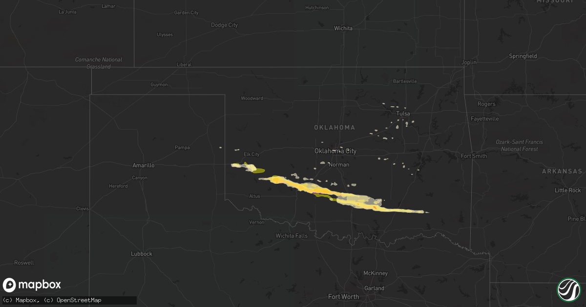
Hail Map in Oklahoma on February 29, 2016
Get this storm
February 29 map
$229
one time, instant access
Download today. No call, no setup
Keep the $229
Bought the map and want the full workflow? Apply the entire $229 to a subscription within 7 days. None of it is wasted.
Every map, not just this one
This buys you this map. Subscription and you get every map we run, in the markets you choose from a few cities to whole states to nationwide. Plus real-time alerts the moment a storm fires.
Contact data
Name, contact info, occupancy, even credit band for addresses in the footprint. You go from where it hit to who to call.
Become the source they trust
Unlimited branding weather history reports on demand. You already have the documented answer ready for the property owner, and you are the one who showed up with it.
Property data and RoofTrace estimates
Pull up any address you have got, its value and the exact code rules for that jurisdiction, straight from One Click Code. Then RoofTrace estimates the squares, pitch, and roof value, priced the way you price.
Storm reports in Oklahoma
Oklahoma
| Date | Description |
|---|---|
| 02/29/20161:55 AM CST | Reported at wal-mart |
| 02/29/20161:10 AM CST | A local report indicates 1.75 inch wind near CONNERVILLE |
| 02/29/201612:52 AM CST | A local report indicates 1.00 inch wind near 5 E SULPHUR |
| 02/29/201612:02 AM CST | Covering the entire ground with some hail drifts |
| 02/28/201611:20 PM CST | A local report indicates 2.00 inch wind near 2 S COX CITY |
| 02/28/201610:58 PM CST | A local report indicates 1.25 inch wind near 4 N MARLOW |
| 02/28/201610:57 PM CST | A local report indicates 2.00 inch wind near 4 WNW STERLING |
| 02/28/201610:55 PM CST | A local report indicates 60 MPH wind near 4 S RUSH SPRINGS |
| 02/28/201610:55 PM CST | A local report indicates 1.75 inch wind near 4 S RUSH SPRINGS |
| 02/28/201610:45 PM CST | A local report indicates 1.25 inch wind near ELGIN |
| 02/28/201610:18 PM CST | A local report indicates 1.50 inch wind near 2 E ELGIN |
| 02/28/20169:35 PM CST | A local report indicates 1.75 inch wind near COOPERTON |
| 02/28/20168:45 PM CST | A local report indicates 58 MPH wind near OKARCHE |
Cities Impacted by Hail Map on February 29, 2016
- Stratford, OK
- Pauls Valley, OK
- Byars, OK
- Paoli, OK
- Wetumka, OK
- Elgin, OK
- Apache, OK
- Fletcher, OK
- Tupelo, OK
- Stonewall, OK
- Roff, OK
- Atoka, OK
- Choctaw, OK
- Harrah, OK
- Cheyenne, OK
- Mounds, OK
- Sapulpa, OK
- Skiatook, OK
- Sand Springs, OK
- Wapanucka, OK
- Bristow, OK
- Stroud, OK
- Depew, OK
- Sayre, OK
- Erick, OK
- Elmore City, OK
- Hennepin, OK
- Lone Wolf, OK
- Carter, OK
- Sentinel, OK
- Granite, OK
- Mountain View, OK
- Lindsay, OK
- Marlow, OK
- Rush Springs, OK
- Lawton, OK
- Tishomingo, OK
- Davis, OK
- Wynnewood, OK
- Mill Creek, OK
- Milburn, OK
- Sulphur, OK
- Carnegie, OK
- Foster, OK
- Roosevelt, OK
- Gotebo, OK
- Hobart, OK
- Stringtown, OK
- Antlers, OK
- Moyers, OK
- Chickasha, OK
- Cement, OK
- Ninnekah, OK
- Sperry, OK
- Tulsa, OK
- Briscoe, TX
- Duncan, OK
- Willow, OK
- Okemah, OK
- Anadarko, OK
- Fort Cobb, OK
- Mcalester, OK
- Dustin, OK
- Finley, OK
- Lane, OK
- Cyril, OK
- Hominy, OK
- Osage, OK
- Pocasset, OK
- Amber, OK
- Bixby, OK
- Jenks, OK
- Oklahoma City, OK
- Coleman, OK
- Blanchard, OK
- Newcastle, OK
- Wewoka, OK
- Seminole, OK
- Broken Arrow, OK
- Snow, OK
- Hanna, OK
- Piedmont, OK
- Maysville, OK
- Tuttle, OK
- Prue, OK
- Indianola, OK
- Jones, OK
- Spencer, OK
- Bradley, OK


