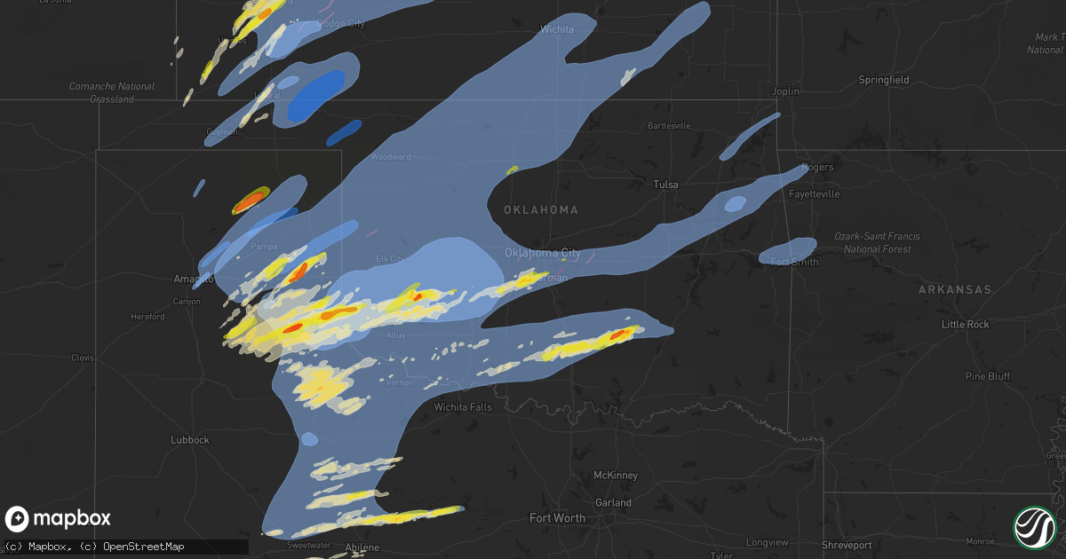
Hail Map on February 26, 2023
Get this storm
February 26 map
$229
one time, instant access
Download today. No call, no setup
Keep the $229
Bought the map and want the full workflow? Apply the entire $229 to a subscription within 7 days. None of it is wasted.
Every map, not just this one
This buys you this map. Subscription and you get every map we run, in the markets you choose from a few cities to whole states to nationwide. Plus real-time alerts the moment a storm fires.
Contact data
Name, contact info, occupancy, even credit band for addresses in the footprint. You go from where it hit to who to call.
Become the source they trust
Unlimited branding weather history reports on demand. You already have the documented answer ready for the property owner, and you are the one who showed up with it.
Property data and RoofTrace estimates
Pull up any address you have got, its value and the exact code rules for that jurisdiction, straight from One Click Code. Then RoofTrace estimates the squares, pitch, and roof value, priced the way you price.
Storm reports
Kansas
| Date | Description |
|---|---|
| 02/26/20235:47 PM CST | Mesonet station fw8871 cimarron. |
| 02/26/20235:44 PM CST | Social media report of flipped irrigation pivots with also a photo of a possible funnel cloud time estimate based off radar. |
| 02/26/20235:35 PM CST | Mesonet station fw8871 cimarron. |
| 02/26/20235:32 PM CST | Storm survey found no solid evidence for a tornado as this previous report has been corrected to thunderstorm wind damage. A video was received via social media of stru |
| 02/26/20235:32 PM CST | A video was received via social media of structural damage on a farm around 8 miles southwest of cimarron. Radar data supports tornadic circulation went over this locat |
| 02/26/20235:30 PM CST | Large tree uprooted in montezuma. Picture of the damage was received via social media. |
| 02/26/20235:29 PM CST | Corrects previous tstm wnd dmg report from 5 nnw the haggard elevator. Social media photos of irrigation pivots flipped time estimates based off radar. |
| 02/26/20235:25 PM CST | Mesonet station ur350 4.4 ne hayne |
| 02/26/20235:15 PM CST | Awos station k19s 1 ne sublette. |
| 02/26/20235:13 PM CST | Pictures on social media show tree damage and windows blown out of the bowling alley in sublette. |
| 02/26/20235:12 PM CST | From sunday 02/26/2023. |
| 02/26/20234:51 PM CST | A local report indicates 1.50 inch wind near 3 NNW PLYMELL |
| 02/26/20234:48 PM CST | Corrects previous tornado report. Possible tornado or wind intensity unknown. |
| 02/26/20234:45 PM CST | Report received from social media. Pictures were included. |
| 02/26/20234:31 PM CST | A local report indicates 1.00 inch wind near 10 NNE HICKOK |
| 02/26/20234:20 PM CST | Report received through social media with photos. |
| 02/26/20234:15 PM CST | Corrects time of previous hail report from ulysses. Report received through social media with photos. |
| 02/26/20234:15 PM CST | Report received through social media. |
| 02/26/20235:29 AM CST | Social media photos of irrigation pivots flipped time estimates based off radar. |
| 02/26/20232:20 AM CST | A local report indicates 62 MPH wind near 1 WNW CLARE |
| 02/26/20232:20 AM CST | A local report indicates 60 MPH wind near 1 W CLARE |
| 02/25/202311:54 PM CST | Report was from kansas mesonet. |
| 02/25/202311:54 PM CST | Report was from kansas mesonet. |
| 02/25/202310:15 PM CST | A damage report of a tree down in the north lane at 14th and country club on the west side of winfield. Time is estimated from radar. |
| 02/25/202310:12 PM CST | Delayed report of a tree down at 150th and indianola rd. A vehicle ran into the tree. Time estimated via radar. |
| 02/25/202310:12 PM CST | Delayed report...roof damage to home. Roof partial peeled back. |
| 02/25/202310:02 PM CST | Delayed report...several trees down. Time estimated by radar. |
| 02/25/202310:02 PM CST | Spotter reported 60 mph winds. |
| 02/25/20239:57 PM CST | A local report indicates 59 MPH wind near MCCONNELL AIR FORCE BAS |
| 02/25/20239:53 PM CST | 58 mph wind recorded at the airport. |
| 02/25/20239:32 PM CST | Off duty firefighter reported a 67 mph gust. |
| 02/25/20238:57 PM CST | 70 mph winds reported by a storm chaser as well as tree limbs down and debris across the road. |
| 02/25/20236:20 PM CST | Reports of a roof over a deck blown off and shed damage...time estimate based off radar and when the photos were taken. |
| 02/25/20236:15 PM CST | Report was from social media. Pivot sprinklers blown over. Pictures were included. |
| 02/25/20236:05 PM CST | Mesonet station spuk1 spearville. |
| 02/25/20236:05 PM CST | Photos of thunderstorm wind damage. |
Texas
| Date | Description |
|---|---|
| 02/26/20235:33 PM CST | A local report indicates 77 MPH wind near 1 ESE PANTEX |
| 02/26/20235:12 PM CST | A local report indicates 67 MPH wind near 1 NW PALO DURO RESERVOI |
| 02/26/20235:11 PM CST | Mesonet station 85 goodnight. |
| 02/26/20234:40 PM CST | Gusts of 58 mph to 80 mph beginning at 3:09 pm cst and ending at 9:41 pm cst. |
| 02/26/20234:36 PM CST | A local report indicates 71 MPH wind near 3 N BORGER |
| 02/26/20234:33 PM CST | A local report indicates 73 MPH wind near 1 W CANYON |
| 02/26/20234:32 PM CST | Curry tx 3272 10086 mesonet station 37 snyder 3e. |
| 02/26/20234:32 PM CST | A local report indicates 74 MPH wind near 6 ENE AMARILLO |
| 02/26/20234:27 PM CST | A local report indicates 79 MPH wind near 9 NNE AMARILLO |
| 02/26/20234:22 PM CST | Reported at fritch 1wnw mesonet station. |
| 02/26/20234:21 PM CST | West texas mesonet kst3. |
| 02/26/20233:52 PM CST | A local report indicates 65 MPH wind near 9 NNE SUNRAY |
| 02/26/20233:15 PM CST | A local report indicates 71 MPH wind near 2 N TEXLINE |
| 02/26/202312:06 AM CST | 58 mph wind gust measured at mckinney national airport. |
| 02/25/202311:30 PM CST | Top part of cedar tree down... Limbs off around it; 2 big cedar trees down in n/ne direction; lifted a shed and moved it 20 ft ne; limbs are down... Moved 30 ft from tr |
| 02/25/20239:12 PM CST | A local report indicates 62 MPH wind near 1 NNW ALBANY |
| 02/25/20239:01 PM CST | A local report indicates 59 MPH wind near 2 WNW SHEPPARD AFB |
| 02/25/20238:55 PM CST | A local report indicates 59 MPH wind near BURKBURNETT |
| 02/25/20238:45 PM CST | A local report indicates 64 MPH wind near 3 W GOODLETT |
| 02/25/20238:36 PM CST | A local report indicates 62 MPH wind near ELECTRA |
| 02/25/20238:35 PM CST | A local report indicates 66 MPH wind near 3 NW SEYMOUR |
| 02/25/20238:26 PM CST | A local report indicates 70 MPH wind near OKLAUNION |
| 02/25/20238:20 PM CST | A local report indicates 61 MPH wind near 4 NNW GOREE |
| 02/25/20238:20 PM CST | A local report indicates 1.00 inch wind near STAMFORD |
| 02/25/20238:10 PM CST | A local report indicates 58 MPH wind near RULE |
| 02/25/20238:05 PM CST | A local report indicates 63 MPH wind near 4 ENE ODELL |
| 02/25/20237:45 PM CST | A local report indicates 63 MPH wind near ROTAN |
| 02/25/20237:40 PM CST | A local report indicates 59 MPH wind near COMANCHE SPRINGS |
| 02/25/20237:39 PM CST | A local report indicates 64 MPH wind near QUANAH |
| 02/25/20237:33 PM CST | Measured by the west texas mesonet as a broken line of thunderstorm moved through. |
| 02/25/20237:31 PM CST | Mesonet station 37 snyder 3e. |
| 02/25/20237:30 PM CST | A local report indicates 71 MPH wind near GOODLETT |
| 02/25/20237:24 PM CST | Measured by the west texas mesonet as a broken line of showers and thunderstorms went through. |
| 02/25/20237:22 PM CST | Measured by the west texas mesonet as a broken line of showers and thunderstorms moved through. |
| 02/25/20237:17 PM CST | Measured by the west texas mesonet as a broken line of showers and thunderstorms moved through. |
| 02/25/20237:03 PM CST | Destroyed out buildings and several trees down 5 miles east of kelton on highway 2697. |
| 02/25/20237:03 PM CST | Measured by the west texas mesonet as a line of thunderstorms moved through. |
| 02/25/20236:59 PM CST | A local report indicates 71 MPH wind near 2 W CHILDRESS |
| 02/25/20236:58 PM CST | Mesonet station wgtt2 wellington 6se. |
| 02/25/20236:55 PM CST | A local report indicates 58 MPH wind near GOODLETT |
| 02/25/20236:55 PM CST | Several reports of quarter size hail in wellington... Roughly 2 miles south of town and 2 to 3 miles southwest of town. |
| 02/25/20236:52 PM CST | 8 wood power poles broken/snapped. Estimated wind speeds of 100 mph. |
| 02/25/20236:52 PM CST | A local report indicates 1.50 inch wind near WELLINGTON |
| 02/25/20236:52 PM CST | Report from mping. |
| 02/25/20236:50 PM CST | Tree uprooted. Estimated winds of 90 mph. |
| 02/25/20236:50 PM CST | A local report indicates 62 MPH wind near 3 SSE ESTELLINE |
| 02/25/20236:50 PM CST | Power lines were brought down in shamrock. |
| 02/25/20236:48 PM CST | Reported at the dozier 3w mesonet site. |
| 02/25/20236:48 PM CST | Three snapped wood power poles found on damage survey. Estimated wind speeds of 100 mph. |
| 02/25/20236:47 PM CST | House/ barn significantly damaged... No longer standing. Tree uprooted and snapped in the area. |
| 02/25/20236:45 PM CST | Wind driven hail has knocked out windows in town. |
| 02/25/20236:41 PM CST | This tornado began at 6:41 pm cst about 8 miles northeast of twitty... Texas. It had a path length of 2.19 miles... A path width of 50 yards... And an estimated peak wi |
| 02/25/20236:37 PM CST | Measured by the west texas mesonet. |
| 02/25/20236:29 PM CST | This brief tornado begin at 6:29 pm cst and ended around 6:30 pm cst. The path length was about 0.20 mile... Had a width of 25 yards... A maximum wind speed of 75 mph.. |
| 02/25/20236:25 PM CST | Measured by the west texas mesonet as a quick-moving thunderstorm went through. |
| 02/25/20236:23 PM CST | Measured by the west texas mesonet as a line of thunderstorms moved through. First severe gust at 6:22pm. |
| 02/25/20236:22 PM CST | Measured by the west texas mesonet as a line of thunderstorms moved through. |
| 02/25/20236:20 PM CST | A local report indicates 1.75 inch wind near 5 E MCLEAN |
| 02/25/20236:15 PM CST | A local report indicates 61 MPH wind near 2 NW LAKE MCCLELLAN |
| 02/25/20236:14 PM CST | A local report indicates 71 MPH wind near CAPROCK CANYON SP |
| 02/25/20236:12 PM CST | Spotter reported a garage door blown in on a business in the city of mclean. |
| 02/25/20236:05 PM CST | A local report indicates 79 MPH wind near 2 W CLARENDON |
| 02/25/20236:05 PM CST | Measured by the west texas mesonet as a thin line of thunderstorms moved through. |
| 02/25/20236:03 PM CST | Mesonet station 108 palo duro 4e |
| 02/25/20236:00 PM CST | An 18 wheeler was blown over and another one jackknifed at mm134 eastbound on i-40. |
Missouri
| Date | Description |
|---|---|
| 02/26/20234:10 AM CST | Asos station kvih vichy rolla asos. |
| 02/26/20233:54 AM CST | Several power lines and a tree down at east ave. Time estimated from radar. |
| 02/26/20233:35 AM CST | Tree in powerlines per social media. |
| 02/26/20233:20 AM CST | Two trees uprooted and blocking highway and a shed collapsed. |
| 02/26/20233:15 AM CST | Roof blown off a house. |
| 02/26/20233:05 AM CST | A local report indicates 70 MPH wind near 3 W BUNCETON |
| 02/26/20233:02 AM CST | 32 highway 3 miles east of lebanon. Wind destroyed a barn... And large tree limbs down on part of a house. |
| 02/26/20233:00 AM CST | Debris scattered on strip in front of stewarts restaurant.....looks like metal roofing. |
| 02/26/20232:59 AM CST | Corrects previous time of tstm wnd dmg report from 1 ene versailles. 1-inch tree limbs broken; shingles blown off. Time estimated based on radar. |
| 02/26/20232:55 AM CST | Damage to a metal outbuilding. Roof off. Time based on radar estimate. |
| 02/26/20232:50 AM CST | Delayed report: electric coop and emergency management reported power pole and electrical damage due to damaging winds. 3500 were without power... Mainly in the souther |
| 02/26/20232:48 AM CST | Tree on a house in niangua. Road is blocked as well... M highway & ac highway. |
| 02/26/20232:48 AM CST | Electric utility damage with numerous outages in eastern benton county per como electric map. |
| 02/26/20232:44 AM CST | Tree down on a home in niangua. |
| 02/26/20232:42 AM CST | Cottonwood tree downed blocking road. Time estimate via radar. |
| 02/26/20232:35 AM CST | A local report indicates 59 MPH wind near ALMA |
| 02/26/20232:30 AM CST | Tree down on house. Wind gust measured at school as 59 mph. Time estimated via radar. |
| 02/26/20232:30 AM CST | Barn destroyed. Time estimated via radar. |
| 02/26/20232:29 AM CST | Downed tree in urbana. |
| 02/26/20232:25 AM CST | Mesonet station fw9611 branson. |
| 02/26/20232:22 AM CST | Tree onto powerline. |
| 02/26/20232:22 AM CST | Highway nn is currently blocked by a tree near the hickory-dallas county line... East of county road 302. |
| 02/26/20232:21 AM CST | Several utility poles snapped. |
| 02/26/20232:20 AM CST | Corrects time of previous tstm wnd dmg report from 2 nw urbana. Two trees uprooted and blocking highway and a shed collapsed. |
| 02/26/20232:15 AM CST | Corrects time of previous tstm wnd dmg report from 4 sw hermitage. Fallen trees in the galmey area. |
| 02/26/20232:15 AM CST | Tree across roadway near pittsburg south of bullseye fuel station. |
| 02/26/20232:11 AM CST | A storage structure collapsed and a fallen tree blocking the road in the co 340 area. Time estimated by radar. |
| 02/26/20232:07 AM CST | Electric utility damage with numerous outages in southeast st clair county per sacosage electric map. |
| 02/26/20232:07 AM CST | Main street between slim wilson and aldersgate is closed because of damage to a downed power pole. |
| 02/26/20232:05 AM CST | Corrects previous tstm wnd dmg report from flemington. Limbs down in roadway in flemington... East of humansville. 2-4 inches in diamter limbs. Flemington is out of pow |
| 02/26/20232:05 AM CST | Limbs down in roadway in flemington... East of humansville. Unknown sizes at this time. |
| 02/26/20232:04 AM CST | Hickory county road 340 near flemington a sawmill building was damaged. |
| 02/26/20232:04 AM CST | Humansville fire reports east of humansville toward flemington on hwy v... Multiple limbs down... And barn damage from straight line winds. On 315 road... Feed troughs |
| 02/26/20231:52 AM CST | Small greenhouse picked up and thrown 100 yards. Metal pipes bent to a 90 degree angle. |
| 02/26/20231:49 AM CST | Public sent in pictures of large tree limbs down. |
| 02/26/20231:47 AM CST | A national weather service storm survey concluded that an ef-0 tornado... With maximum wind speeds of 76 mph... Uprooted a few weak trees with large branches also broke |
| 02/26/20231:45 AM CST | Delayed report: tree down blocking yy highway 1 mile east of 39. |
| 02/26/20231:33 AM CST | Two separate reports of trees down on highway 76 east of cassville. |
| 02/26/20231:30 AM CST | Straightline winds caused a barn to collapse. Time estimated by radar. |
| 02/26/20231:30 AM CST | Delayed report: 3 trailer homes lost roofs at this location off farm road 2000. |
| 02/26/20231:27 AM CST | Delayed report. Barns down and trees down off 37 highway. Powerpole also broken near this location. A cable was down in the roadway just south of this location at highw |
| 02/26/20231:27 AM CST | Three separate reports of powerlines down in southeast monett near maple... Kyler and summit streets. |
| 02/26/20231:27 AM CST | Delayed report: 2 large trees in the road just east of butterfield on highway u. |
| 02/26/20231:25 AM CST | A national weather service storm survey concluded that an ef-0 tornado... With maximum wind speeds of 77 mph... Heavily damaged a machine barn. Tin was blown in a cyclo |
| 02/26/20231:25 AM CST | An nws survey revealed that straight-line wind gusts caused roof damage to a turkey farm. Time estimated by radar. |
| 02/26/20231:24 AM CST | Corrects previous tstm wnd dmg report from 2 sw harwood. Two outbuildings and two barns destroyed. Debris thrown 500 yards to the north. |
| 02/26/20231:14 AM CST | Avilla fire dept is reporting pieces of a barn |
| 02/26/20231:04 AM CST | Tree down on a home. |
| 02/26/20231:02 AM CST | A national weather service storm survey concluded that an ef-1 tornado... With maximum wind speeds of 105 mph... Damaged or destroyed more than 10 outbuildings and over |
| 02/26/202312:59 AM CST | Significant damage to a barn and other farm outbuildings... Along with a power outage to the area ... On poppy drive between kodiak road and jaguar road in rural neosho |
| 02/26/202312:59 AM CST | Shed destroyed... Rolled rv... Downed trees... And debris blown onto powerlines. |
| 02/26/202312:57 AM CST | Report from mping: 1-inch tree limbs broken; shingles blown off. Time based on radar estimate. |
| 02/26/202312:56 AM CST | Downed trees and utility poles. |
Oklahoma
| Date | Description |
|---|---|
| 02/26/20235:45 PM CST | Mesonet station beav beaver. |
| 02/26/20235:16 PM CST | A local report indicates 60 MPH wind near 1 W GUYMON |
| 02/26/20234:37 PM CST | Corrects previous tstm wnd gst report from 1 w guymon. |
| 02/26/20234:30 PM CST | A local report indicates 68 MPH wind near 2 ENE GOODWELL |
| 02/26/202312:30 AM CST | Tree down. |
| 02/26/202312:27 AM CST | Power pole down. |
| 02/26/202312:22 AM CST | Tree and barn roof damage. |
| 02/26/202312:20 AM CST | Corrects previous tstm wnd gst report from 1 n afton. |
| 02/26/202312:04 AM CST | A local report indicates 64 MPH wind near 5 WSW TAHLEQUAH |
| 02/25/202311:58 PM CST | Large tree limb down and lawn furniture scattered. |
| 02/25/202311:35 PM CST | A local report indicates 58 MPH wind near 1 WNW LANE |
| 02/25/202311:35 PM CST | A local report indicates 58 MPH wind near 5 ESE CALERA |
| 02/25/202311:25 PM CST | A local report indicates 60 MPH wind near STIGLER |
| 02/25/202311:25 PM CST | A local report indicates 60 MPH wind near PORTER |
| 02/25/202311:25 PM CST | A local report indicates 60 MPH wind near SALLISAW |
| 02/25/202310:55 PM CST | A local report indicates 61 MPH wind near 3 ESE HOLDENVILLE |
| 02/25/202310:33 PM CST | A local report indicates 1.75 inch wind near STONEWALL |
| 02/25/202310:32 PM CST | Sheet metal roof removed from outbuilding. Time estimated by radar. |
| 02/25/202310:25 PM CST | A local report indicates 86 MPH wind near 6 SW FITTSTOWN |
| 02/25/202310:15 PM CST | A local report indicates 69 MPH wind near 4 NNE SULPHUR |
| 02/25/202310:10 PM CST | A local report indicates 60 MPH wind near 3 ESE BYARS |
| 02/25/202310:00 PM CST | A local report indicates 59 MPH wind near 7 SW SOONER LAKE |
| 02/25/20239:55 PM CST | A local report indicates 61 MPH wind near SHAWNEE |
| 02/25/20239:55 PM CST | A local report indicates 59 MPH wind near 1 SSW PAULS VALLEY |
| 02/25/20239:47 PM CST | Beginning of tornado path; based on radar estimate and beginning of damage reports. |
| 02/25/20239:42 PM CST | Beginning of tornado path; based on radar estimate. |
| 02/25/20239:40 PM CST | Damage to trees... Car port tops; some shingles removed from roofs... Metal shop overturned... Roof removed from old shop. Time estimated from radar. |
| 02/25/20239:36 PM CST | A local report indicates 1.00 inch wind near 6 NNW STELLA |
| 02/25/20239:30 PM CST | 30ft tall large tree over 12-in diameter uprooted. Backyard fence damaged and minor roof damage to home. |
| 02/25/20239:25 PM CST | A local report indicates 77 MPH wind near 7 NW VELMA |
| 02/25/20239:25 PM CST | A local report indicates 60 MPH wind near 1 W KINGFISHER |
| 02/25/20239:20 PM CST | A local report indicates 58 MPH wind near 2 N YUKON |
| 02/25/20239:19 PM CST | A local report indicates 59 MPH wind near 1 NE OKARCHE |
| 02/25/20239:18 PM CST | Beginning of tornado path; time radar estimate; based on beginning damage reports; tornado traveled ne into norman. |
| 02/25/20239:16 PM CST | A local report indicates 59 MPH wind near OKLAHOMA CITY |
| 02/25/20239:15 PM CST | Three sections of fence down |
| 02/25/20239:15 PM CST | A local report indicates 60 MPH wind near 1 N RINGLING |
| 02/25/20239:12 PM CST | A local report indicates 1.00 inch wind near NEWCASTLE |
| 02/25/20239:10 PM CST | A local report indicates 66 MPH wind near 2 S DUNCAN |
| 02/25/20239:09 PM CST | Roof removed from trailer in hillsdale. Time estimated by radar. |
| 02/25/20239:07 PM CST | Beginning of tornado path; based on radar estimate and beginning of damage reports. |
| 02/25/20239:05 PM CST | Time estimated based on radar. |
| 02/25/20239:05 PM CST | Time is radar estimated. |
| 02/25/20239:00 PM CST | Time is radar estimated. |
| 02/25/20239:00 PM CST | A local report indicates 59 MPH wind near 2 SSW MINCO |
| 02/25/20239:00 PM CST | A local report indicates 65 MPH wind near 4 NW WALTERS |
| 02/25/20238:56 PM CST | A local report indicates 71 MPH wind near CHICKASHA |
| 02/25/20238:55 PM CST | A local report indicates 65 MPH wind near 2 SSE CHICKASHA |
| 02/25/20238:55 PM CST | A local report indicates 1.00 inch wind near CHICKASHA |
| 02/25/20238:55 PM CST | A local report indicates 60 MPH wind near 4 NW WALTERS |
| 02/25/20238:52 PM CST | Beginning of tornado path; based on radar estimate and beginning of damage reports. |
| 02/25/20238:46 PM CST | A local report indicates 72 MPH wind near LAWTON |
| 02/25/20238:40 PM CST | A local report indicates 69 MPH wind near 3 W GRANDFIELD |
| 02/25/20238:35 PM CST | A local report indicates 68 MPH wind near 7 W HINTON |
| 02/25/20238:35 PM CST | A local report indicates 64 MPH wind near 3 SSE STECKER |
| 02/25/20238:31 PM CST | Farm shed destroyed. Time based on radar data. |
| 02/25/20238:30 PM CST | A local report indicates 66 MPH wind near 3 SSE FORT COBB RESERVO |
| 02/25/20238:30 PM CST | A local report indicates 80 MPH wind near 1 S BRIDGEPORT |
| 02/25/20238:30 PM CST | A local report indicates 66 MPH wind near 7 W HINTON |
| 02/25/20238:20 PM CST | Wind damage to home and outbuilding... Utility lines down. |
| 02/25/20238:16 PM CST | A local report indicates 1.00 inch wind near CARNEGIE |
| 02/25/20238:15 PM CST | A local report indicates 63 MPH wind near 3 N ALTUS |
| 02/25/20238:10 PM CST | A local report indicates 69 MPH wind near 4 S TIPTON |
| 02/25/20238:09 PM CST | Spotter network report. |
| 02/25/20238:01 PM CST | A local report indicates 77 MPH wind near CLINTON |
| 02/25/20237:58 PM CST | A local report indicates 73 MPH wind near 3 SE HOBART |
| 02/25/20237:55 PM CST | A local report indicates 77 MPH wind near 4 SE HOBART |
| 02/25/20237:55 PM CST | A local report indicates 62 MPH wind near 3 N ALTUS |
| 02/25/20237:53 PM CST | A local report indicates 70 MPH wind near CLINTON |
| 02/25/20237:49 PM CST | A local report indicates 59 MPH wind near ALTUS AIR FORCE BASE |
| 02/25/20237:45 PM CST | Beginning of tornado path; based on radar estimate and beginning of damage reports; traveled ne into hobart. |
| 02/25/20237:35 PM CST | A local report indicates 62 MPH wind near 2 NNW HESTER |
| 02/25/20237:21 PM CST | Powerlines reported down along highway 152 west of sayre. Time estimated by radar. |
| 02/25/20237:15 PM CST | Tornado confirmed from a combination of spotter reports and radar. Damage survey will be conducted in the area on tuesday. |
| 02/25/20237:15 PM CST | A local report indicates 75 MPH wind near 3 W GOULD |
| 02/25/20237:15 PM CST | 2 manufactured homes destroyed. 1 state barn damaged. Time estimated based on radar. |
| 02/25/20237:02 PM CST | Beginning of tornado path; based on radar estimate and beginning of damage reports. |
| 02/25/20237:00 PM CST | A local report indicates 78 MPH wind near 4 ESE ERICK |
Illinois
| Date | Description |
|---|---|
| 02/26/20235:21 AM CST | A local report indicates 60 MPH wind near 3 NNE NEW HARTFORD |
| 02/26/20235:02 AM CST | Emailed pictures indicate a tin machine shed lost parts of its roofing. |
Ohio
| Date | Description |
|---|---|
| 02/26/20233:15 AM CST | Roof of garage damaged. Several large branches down. Possible tornado. |
Arkansas
| Date | Description |
|---|---|
| 02/26/20231:25 AM CST | Power lines down. |
| 02/26/20231:25 AM CST | Large tree limbs broken. Power poles broken. |
| 02/26/20231:22 AM CST | A local report indicates 59 MPH wind near EXCELSIOR |
| 02/26/20231:13 AM CST | Large tree limbs broken. |
| 02/26/20231:05 AM CST | Large tree limbs broken. |
| 02/25/202311:05 PM CST | A local report indicates 58 MPH wind near FAYETTEVILLE |
Cities Impacted by Hail Map on February 26, 2023
- McIntire, IA
- Riceville, IA
- Chester, IA
- Stacyville, IA
- Richfield, KS
- Sunray, TX
- Stratford, TX
- Gruver, TX
- Panhandle, TX
- Lakin, KS
- Ulysses, KS
- Satanta, KS
- Amarillo, TX
- Pampa, TX
- Borger, TX
- Miami, TX
- Garden City, KS
- Stinnett, TX
- Spearman, TX
- Perryton, TX
- Sublette, KS
- Pierceville, KS
- Skellytown, TX
- Copeland, KS
- Ingalls, KS
- Montezuma, KS
- Dighton, KS
- Ness City, KS
- Cimarron, KS
- Beeler, KS
- Mclean, TX
- Guymon, OK
- Goodwell, OK
- Hooker, OK
- Kismet, KS
- Liberal, KS
- Plains, KS
- Meade, KS
- Forgan, OK
- Beaver, OK
- Hugoton, KS
- Turpin, OK
- Gate, OK
- Englewood, KS
- Fowler, KS
- Minneola, KS
- Ensign, KS
- Dodge City, KS
- Booker, TX
- Canadian, TX
- Mobeetie, TX
- Shamrock, TX
- Quitaque, TX
- Groom, TX
- White Deer, TX
- Claude, TX
- Wheeler, TX
- Ashland, KS
- Clarendon, TX
- Wright, KS
- Jetmore, KS
- Silverton, TX
- Spearville, KS
- Bazine, KS
- Brownell, KS
- Hanston, KS
- Offerle, KS
- Kinsley, KS
- Larned, KS
- Burdett, KS
- McCracken, KS
- Alexander, KS
- Ransom, KS
- Hays, KS
- Ellis, KS
- Briscoe, TX
- Reydon, OK
- Hedley, TX
- Lelia Lake, TX
- Lewis, KS
- Belpre, KS
- Rozel, KS
- Garfield, KS
- Nekoma, KS
- La Crosse, KS
- Rush Center, KS
- Memphis, TX
- Wellington, TX
- Childress, TX
- Lakeview, TX
- Crawford, OK
- Durham, OK
- Macksville, KS
- Bucklin, KS
- Ford, KS
- St John, KS
- Schoenchen, KS
- Hoisington, KS
- Gorham, KS
- Liebenthal, KS
- Pfeifer, KS
- Albert, KS
- Olmitz, KS
- Pawnee Rock, KS
- Otis, KS
- Victoria, KS
- Great Bend, KS
- Russell, KS
- Bison, KS
- Walker, KS
- Wakeeney, KS
- Paradise, KS
- Quail, TX
- Turkey, TX
- Matador, TX
- Paducah, TX
- Tell, TX
- Cee Vee, TX
- Erick, OK
- Texola, OK
- Arnett, OK
- Cheyenne, OK
- Sweetwater, OK
- Laverne, OK
- Sayre, OK
- Hollis, OK
- Dodson, TX
- Gould, OK
- Quanah, TX
- Mangum, OK
- Vinson, OK
- Hudson, KS
- Chase, KS
- Raymond, KS
- Ellinwood, KS
- Claflin, KS
- Holyrood, KS
- Bushton, KS
- Bunker Hill, KS
- Dorrance, KS
- Wilson, KS
- Gage, OK
- Fort Supply, OK
- Shattuck, OK
- Sharon, OK
- Buffalo, OK
- Fargo, OK
- Woodward, OK
- Higgins, TX
- Leedey, OK
- Hammon, OK
- Elk City, OK
- Carter, OK
- Willow, OK
- Eldorado, OK
- Duke, OK
- Dickens, TX
- Roaring Springs, TX
- Crowell, TX
- Chillicothe, TX
- Benjamin, TX
- Seymour, TX
- Altus, OK
- Elmer, OK
- Olustee, OK
- Headrick, OK
- Altus Afb, OK
- Mountain Park, OK
- Roosevelt, OK
- Blair, OK
- Lone Wolf, OK
- Granite, OK
- Sentinel, OK
- Butler, OK
- Canute, OK
- Foss, OK
- Dill City, OK
- Hobart, OK
- Vici, OK
- Taloga, OK
- Mutual, OK
- Camargo, OK
- Mooreland, OK
- Tipton, OK
- Vernon, TX
- Frederick, OK
- Odell, TX
- Davidson, OK
- Electra, TX
- Oklaunion, TX
- Munday, TX
- Goree, TX
- Harrold, TX
- Rocky, OK
- Cordell, OK
- Gotebo, OK
- Clinton, OK
- Arapaho, OK
- Custer City, OK
- Bessie, OK
- Corn, OK
- Seiling, OK
- Putnam, OK
- Snyder, TX
- Jayton, TX
- Aspermont, TX
- Sweetwater, TX
- Loraine, TX
- Roscoe, TX
- Hermleigh, TX
- Rotan, TX
- Roby, TX
- Old Glory, TX
- Rochester, TX
- O'Brien, TX
- Knox City, TX
- Mountain View, OK
- Snyder, OK
- Lawton, OK
- Sylvester, TX
- Hamlin, TX
- McCaulley, TX
- Rule, TX
- Weinert, TX
- Hollister, OK
- Haskell, TX
- Colony, OK
- Weatherford, OK
- Hydro, OK
- Geary, OK
- Chester, OK
- Carnegie, OK
- Binger, OK
- Oakwood, OK
- Fay, OK
- Greenfield, OK
- Canton, OK
- Hinton, OK
- Thomas, OK
- Lookeba, OK
- Watonga, OK
- Fort Cobb, OK
- Freedom, OK
- Waynoka, OK
- Alva, OK
- Carmen, OK
- Longdale, OK
- Southard, OK
- Cleo Springs, OK
- Dacoma, OK
- Okeene, OK
- Fairview, OK
- Aline, OK
- Burlington, OK
- Hitchcock, OK
- Isabella, OK
- Helena, OK
- Cherokee, OK
- Ringwood, OK
- Cache, OK
- Loveland, OK
- Medicine Park, OK
- Indiahoma, OK
- Apache, OK
- Elgin, OK
- Anson, TX
- Merkel, TX
- Stamford, TX
- Hennessey, OK
- Meno, OK
- Kingfisher, OK
- Omega, OK
- Ames, OK
- Calumet, OK
- Loyal, OK
- Okarche, OK
- Minco, OK
- Union City, OK
- Chickasha, OK
- Anadarko, OK
- El Reno, OK
- Cement, OK
- Verden, OK
- Gracemont, OK
- Cyril, OK
- Pocasset, OK
- Fletcher, OK
- Fort Sill, OK
- Amber, OK
- Chattanooga, OK
- Manter, KS
- Tyrone, OK
- Mankato, KS
- Elkhart, KS
- Moscow, KS
- Johnson, KS
- Holcomb, KS
- Walters, OK
- Geronimo, OK
- Grandfield, OK
- Faxon, OK
- Devol, OK
- Avoca, TX
- Lueders, TX
- Throckmorton, TX
- Lahoma, OK
- Enid, OK
- Nash, OK
- Jet, OK
- Drummond, OK
- Carrier, OK
- Goltry, OK
- Waukomis, OK
- Blanchard, OK
- Tuttle, OK
- Mustang, OK
- Abilene, TX
- Albany, TX
- Yukon, OK
- Newcastle, OK
- Oklahoma City, OK
- Bethany, OK
- Wheatland, OK
- Norman, OK
- Washington, OK
- Breckenridge, TX
- Amorita, OK
- Waldron, KS
- Kiowa, KS
- Manchester, OK
- Wakita, OK
- Hazelton, KS
- Anthony, KS
- Attica, KS
- Medicine Lodge, KS
- Sharon, KS
- Hardtner, KS
- Harper, KS
- Bluff City, KS
- Freeport, KS
- Danville, KS
- Wellington, KS
- Pond Creek, OK
- Milan, KS
- Conway Springs, KS
- Caldwell, KS
- Argonia, KS
- Clearwater, KS
- Mayfield, KS
- Medford, OK
- Kremlin, OK
- Milton, KS
- Spivey, KS
- Kingman, KS
- Norwich, KS
- Cheney, KS
- Viola, KS
- Goddard, KS
- Wichita, KS
- Valley Center, KS
- Peck, KS
- Haysville, KS
- Kechi, KS
- Hunter, OK
- Lamont, OK
- Belle Plaine, KS
- South Haven, KS
- Deer Creek, OK
- Newalla, OK
- Jones, OK
- Arcadia, OK
- Edmond, OK
- Choctaw, OK
- Spencer, OK
- Luther, OK
- Noble, OK
- Tecumseh, OK
- Harrah, OK
- Shawnee, OK
- Mcloud, OK
- Wellston, OK
- Rush Springs, OK
- Duncan, OK
- Marlow, OK
- Burkburnett, TX
- Iowa Park, TX
- Wichita Falls, TX
- Waurika, OK
- Comanche, OK
- Hastings, OK
- Temple, OK
- Randlett, OK
- Ringling, OK
- Loco, OK
- Healdton, OK
- Graham, OK
- Hennepin, OK
- Ratliff City, OK
- Lindsay, OK
- Foster, OK
- Elmore City, OK
- Tussy, OK
- Wilson, OK
- Springer, OK
- Maysville, OK
- Paoli, OK
- Davis, OK
- Pauls Valley, OK
- Wynnewood, OK
- Ardmore, OK
- Ryan, OK
- Strawn, TX
- Graford, TX
- Graham, TX
- Meeker, OK
- Earlsboro, OK
- Prague, OK
- Chandler, OK
- Davenport, OK
- Stroud, OK
- Sparks, OK
- Ada, OK
- Sulphur, OK
- Roff, OK
- Stratford, OK
- Dougherty, OK
- Seminole, OK
- Paden, OK
- Depew, OK
- Towanda, KS
- Greenwich, KS
- Rose Hill, KS
- Mulvane, KS
- Benton, KS
- Andover, KS
- Mcconnell Afb, KS
- Derby, KS
- Augusta, KS
- Douglass, KS
- El Dorado, KS
- Udall, KS
- Potwin, KS
- Oxford, KS
- Rock, KS
- Nardin, OK
- Blackwell, OK
- Newkirk, OK
- Arkansas City, KS
- Braman, OK
- Winfield, KS
- Geuda Springs, KS
- Atlanta, KS
- Burden, KS
- Garber, OK
- Tonkawa, OK
- Fairmont, OK
- Perry, OK
- Billings, OK
- Bison, OK
- Covington, OK
- Ponca City, OK
- Red Rock, OK
- Marland, OK
- Douglas, OK
- Hawley, TX
- Rolla, KS
- Ninnekah, OK
- Konawa, OK
- Fitzhugh, OK
- Stonewall, OK
- Mill Creek, OK
- Allen, OK
- Fittstown, OK
- Boley, OK
- Okemah, OK
- Castle, OK
- Wewoka, OK
- Sasakwa, OK
- Wetumka, OK
- Dexter, KS
- Tupelo, OK
- Holdenville, OK
- Calvin, OK
- Atwood, OK
- Weleetka, OK
- Okmulgee, OK
- Bristow, OK
- Beggs, OK
- Henryetta, OK
- Centrahoma, OK
- Morris, OK
- Haskell, OK
- Maple City, KS
- Cambridge, KS
- Cedar Vale, KS
- Latham, KS
- Howard, KS
- Moline, KS
- Grenola, KS
- Leon, KS
- Coalgate, OK
- Stuart, OK
- Wardville, OK
- Kiowa, OK
- Boynton, OK
- Elk Falls, KS
- Longton, KS
- Pittsburg, OK
- Council Hill, OK
- Oktaha, OK
- Porter, OK
- Taft, OK
- Muskogee, OK
- Coweta, OK
- Fall River, KS
- Fort Gibson, OK
- Hulbert, OK
- Wagoner, OK
- Locust Grove, OK
- Chouteau, OK
- Tahlequah, OK
- Stilwell, OK
- Park Hill, OK
- Proctor, OK
- Welling, OK
- Rose, OK
- Peggs, OK
- Oaks, OK
- Kansas, OK
- Twin Oaks, OK
- Westville, OK
- Fredonia, KS
- Yates Center, KS
- Buffalo, KS
- Humboldt, KS
- Chanute, KS
- Benedict, KS
- Toronto, KS
- Piqua, KS
- Iola, KS
- Watts, OK
- Big Cabin, OK
- Vinita, OK
- Adair, OK
- Afton, OK
- Fairland, OK
- Wyandotte, OK
- Miami, OK
- Seneca, MO
- Colcord, OK
- Siloam Springs, AR
- Gentry, AR
- Sallisaw, OK
- Muldrow, OK
- Gans, OK
- Roland, OK
- Bentonville, AR
- Decatur, AR
- Van Buren, AR
- Uniontown, AR
- Cedarville, AR
- Rudy, AR
- Chester, AR
- Cave Springs, AR
- Alma, AR
- Mountainburg, AR
- Nolan, TX
- Ira, TX
- Fort Smith, AR
- Arkoma, OK
- Mulberry, AR
- Piedmont, OK