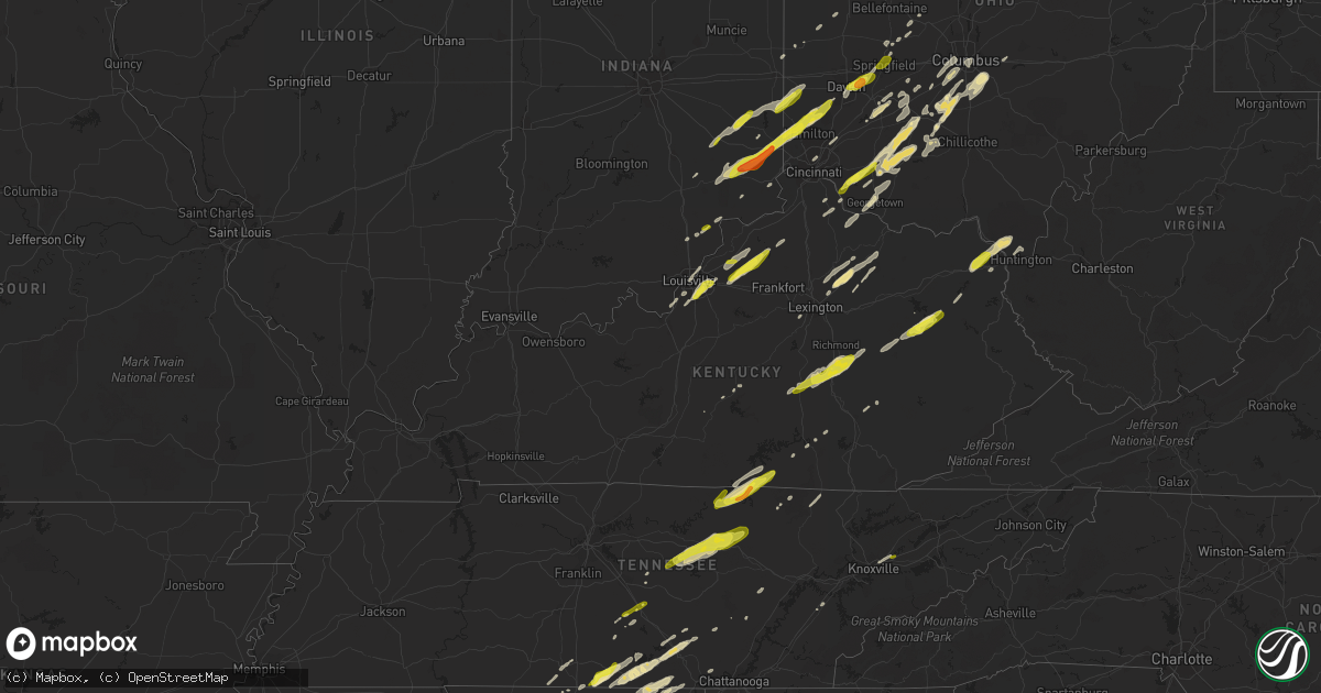
Hail Map in Kentucky on February 24, 2017
Get this storm
February 24 map
$229
one time, instant access
Download today. No call, no setup
Keep the $229
Bought the map and want the full workflow? Apply the entire $229 to a subscription within 7 days. None of it is wasted.
Every map, not just this one
This buys you this map. Subscription and you get every map we run, in the markets you choose from a few cities to whole states to nationwide. Plus real-time alerts the moment a storm fires.
Contact data
Name, contact info, occupancy, even credit band for addresses in the footprint. You go from where it hit to who to call.
Become the source they trust
Unlimited branding weather history reports on demand. You already have the documented answer ready for the property owner, and you are the one who showed up with it.
Property data and RoofTrace estimates
Pull up any address you have got, its value and the exact code rules for that jurisdiction, straight from One Click Code. Then RoofTrace estimates the squares, pitch, and roof value, priced the way you price.
Storm reports in Kentucky
Kentucky
| Date | Description |
|---|---|
| 02/23/201711:55 PM CST | Several large branches down |
| 02/23/201711:50 PM CST | Fire department called out for tree smoldering on power lines |
| 02/23/20179:50 PM CST | . |
| 02/23/20176:59 PM CST | Tree limbs down near intersection of hwy 16 and cemetary rd. Time estimated by radar. |
| 02/23/20176:59 PM CST | Large tree down near us 127 near owen county line. Time estimated by radar. |
| 02/23/20176:51 PM CST | Trees reported down. |
| 02/23/20176:45 PM CST | Several trees down in yard. Time estimated by radar. |
All States Impacted by Hail Map on February 24, 2017
Cities Impacted by Hail Map on February 24, 2017
- Pulaski, TN
- Remus, MI
- Vandalia, MI
- Cassopolis, MI
- Jones, MI
- Union, MI
- Mio, MI
- Mount Pleasant, MI
- Blanchard, MI
- Cable, OH
- Woodstock, OH
- New Buffalo, MI
- Michigan City, IN
- Ypsilanti, MI
- Lynchburg, TN
- Winchester, TN
- Estill Springs, TN
- Tullahoma, TN
- Cadillac, MI
- Merritt, MI
- Lewiston, MI
- Falmouth, MI
- Comins, MI
- Tustin, MI
- Grayling, MI
- McBain, MI
- Marion, MI
- Lake City, MI
- Roscommon, MI
- Carlisle, KY
- Decherd, TN
- Pelham, TN
- Hillsboro, TN
- Louisville, KY
- Hudson, MI
- Livonia, MI
- Dearborn Heights, MI
- Redford, MI
- Detroit, MI
- Garden City, MI
- Canton, MI
- Westland, MI
- Millersburg, KY
- Paris, KY
- Flatwoods, KY
- Argillite, KY
- Kitts Hill, OH
- Russell, KY
- Pedro, OH
- Grayson, KY
- Greenup, KY
- Ironton, OH
- Ashland, KY
- College Corner, OH
- Camden, OH
- Eaton, OH
- Liberty, IN
- Milan, IN
- Trenton, OH
- Germantown, OH
- New Trenton, IN
- Sunman, IN
- West Harrison, IN
- Okeana, OH
- Butlerville, IN
- Middletown, OH
- Versailles, IN
- Seven Mile, OH
- Oxford, OH
- Hamilton, OH
- Franklin, OH
- Aurora, IN
- Miamisburg, OH
- Brookville, IN
- Holton, IN
- Cedar Grove, IN
- Guilford, IN
- Batesville, IN
- Osgood, IN
- Somerville, OH
- Philipp, MS
- Minter City, MS
- Bethlehem, KY
- Shelbyville, KY
- Pleasureville, KY
- Eminence, KY
- Jamestown, OH
- Jeffersonville, OH
- Clinton, MI
- Wellington, KY
- Hazel Green, KY
- Ezel, KY
- West Liberty, KY
- Campton, KY
- Portage, MI
- Vicksburg, MI
- Turner, MI
- Au Gres, MI
- Estillfork, AL
- Sherwood, TN
- South Pittsburg, TN
- Freeland, MI
- Dowagiac, MI
- West Branch, MI
- Gladwin, MI
- Mount Vernon, KY
- Berea, KY
- Nicholasville, KY
- Versailles, KY
- Beverly Shores, IN
- Philadelphia, TN
- Sweetwater, TN
- Shelbyville, TN
- Milan, MI
- Saline, MI
- Britton, MI
- Tipton, MI
- Tecumseh, MI
- Owenton, KY
- Smithfield, KY
- Lockport, KY
- Simpsonville, KY
- Beaverton, MI
- Coleman, MI
- Milton, TN
- Greenwood, MS
- Sidon, MS
- Mascot, TN
- Strawberry Plains, TN
- Knoxville, TN
- Ann Arbor, MI
- Isola, MS
- Bell Buckle, TN
- Bellevue, OH
- Atlanta, MI
- Hillman, MI
- Cookeville, TN
- Hamersville, OH
- Felicity, OH
- Georgetown, OH
- Rose City, MI
- Batavia, OH
- Amelia, OH
- Williamsburg, OH
- New Holland, OH
- Mount Sterling, OH
- Williamsport, OH
- Washington Court House, OH
- Circleville, OH
- Clarksburg, OH
- Fairborn, OH
- Dayton, OH
- Curran, MI
- Greensburg, IN
- Rushville, IN
- Connersville, IN
- West College Corner, IN
- Laurel, IN
- Belvidere, TN
- Crossville, TN
- Pikeville, TN
- Inverness, MS
- Indianola, MS
- Bloomingburg, OH
- Oldenburg, IN
- Clare, MI
- Bremen, IN
- Mishawaka, IN
- South Bend, IN
- East Tawas, MI
- Manchester, KY
- Tyner, KY
- Annville, KY
- Mount Orab, OH
- Sardinia, OH
- Lynchburg, OH
- Fairview, MI
- Monterey, TN
- Silver Point, TN
- Liberty, TN
- Buffalo Valley, TN
- Smithville, TN
- Baxter, TN
- Whitwell, TN
- Byrdstown, TN
- Livingston, TN
- Monroe, TN
- Allons, TN
- Albany, KY
- Carrollton, MS
- Crestwood, KY
- La Grange, KY
- Hanover, IN
- Madison, IN
- Farwell, MI
- Alexandria, KY
- Chatfield, OH
- Bucyrus, OH
- Sycamore, OH
- Bloomville, OH
- Clayton, MI
- Manitou Beach, MI
- Onsted, MI
- Adrian, MI
- Grove City, OH
- London, OH
- Columbus, OH
- Galloway, OH
- Scipio, IN
- North Vernon, IN
- Sabina, OH
- Leesburg, OH
- Scobey, MS
- Houghton Lake, MI
- Wilmington, OH
- Oscoda, MI
- Hillsboro, OH
- Xenia, OH
- Plymouth, IN
- Harrisonburg, LA
- Flintville, TN
- Huntland, TN
- Malinta, OH
- Napoleon, OH
- Holgate, OH
- Greenville, MS
- Urbana, OH
- Paint Lick, KY
- Waco, KY
- Brodhead, KY
- Crab Orchard, KY
- Frankfort, OH
- South Branch, MI
- Charleston, MS
- Yellow Springs, OH
- Enon, OH
- Springfield, OH
- Waynesburg, KY
- Ewing, KY
- Mayslick, KY
- Cynthiana, KY
- Sidney, OH
- Greenville, OH
- Alpha, KY
- Celina, TN
- Burkesville, KY
- Merrill, MI
- Hemlock, MI
- Ardmore, TN
- Ardmore, AL
- Elkmont, AL
- Versailles, OH
- Russia, OH
- New Vienna, OH
- Rising Sun, IN
- Stevenson, AL
- Hollansburg, OH
- Fountain City, IN
- Belleville, MI
- Pall Mall, TN
- Lachine, MI
- Duck Hill, MS
- McCarley, MS
- Jamestown, TN
- Stanton, KY
- Slade, KY
- Ravenna, KY
- Irvine, KY
- Mulberry, TN
- Fayetteville, TN
- Kelso, TN
- Taft, TN
- Kalkaska, MI
- Orient, OH
- Ashville, OH
- Greenfield, OH
- Canal Winchester, OH
- Lockbourne, OH
- Lithopolis, OH
- Groveport, OH
- Wheeler, MI
- Midland, MI
- Berrien Springs, MI
- Berrien Center, MI
- Niles, MI
- Clyde, OH
- Lakeville, IN
- Stanford, KY
- Attica, OH
- New Washington, OH
- Bryan, OH
- Elora, TN
- Marysville, OH
- North Lewisburg, OH
- Hollandale, MS
- Rickman, TN
- Dowelltown, TN
- Sparta, TN
- Crawford, TN
- Saint Helen, MI
- Somerset, KY
- Cincinnati, OH
- Underwood, IN
- Marysville, IN
- Lexington, IN
- Three Rivers, MI
- Schoolcraft, MI
- Wartrace, TN
- Mansfield, OH
- Readyville, TN
- Rush, KY
- Catlettsburg, KY
- Martinsville, OH
- Fayetteville, OH
- Bethel, OH
- Monticello, KY
- Alger, MI
- Athens, AL
- Sunflower, MS
- Altamont, TN
- South Salem, OH
- Bainbridge, OH
- Fairdale, KY
- Prospect, TN
- Minor Hill, TN
- Gruetli Laager, TN
- Coalmont, TN
- Hazel Green, AL
- Tracy City, TN
- Brooks, KY
- Luzerne, MI
- New Richmond, OH
- Winchester, OH
- Greensburg, KY
- Helenwood, TN
- Oneida, TN
- Winfield, TN
- Moscow, OH
- California, KY
- Elizabeth, IN
- Wapakoneta, OH
- Lakeview, OH
- Waynesfield, OH
- New Hampshire, OH
- Anderson, AL
- Rogersville, AL
- Nabb, IN
- Hicksville, OH
- Edgerton, OH
- Canaan, IN
- Cross Plains, IN
- Cedarville, OH
- Harrisburg, OH
- Burnside, KY
- Bronston, KY
- Beechgrove, TN
- Three Oaks, MI
- Galien, MI
- Buchanan, MI
- Haslett, MI
- East Lansing, MI
- Fackler, AL
- Scottsboro, AL
- Bridgeport, AL
- Prospect, KY
- Jeffersonville, IN
- Sandy Hook, KY
- Isonville, KY
- Tillatoba, MS
- Herron, MI
- Millersport, OH
- Pataskala, OH
- Hebron, OH
- Kirkersville, OH
- Plymouth, MI
- Lakeside, MI
- Hilham, TN
- Brooksville, KY
- Foster, KY
- Augusta, KY
- Elkhart, IN
- Edwardsburg, MI
- Tawas City, MI
- Weidman, MI
- Rosebush, MI
- Raymond, OH
- Frenchburg, KY
- South Solon, OH
- Lexington, KY
- Campbellsville, KY
- Elkfork, KY
- Owosso, MI
- Laingsburg, MI
- South Point, OH
- Chesapeake, OH
- Henryville, IN
- Prudenville, MI
- Nevada, OH
- Berlin Heights, OH
- Vermilion, OH
- Huron, OH
- Twining, MI
- Omer, MI
- Standish, MI
- Belzoni, MS
- Mason, OH
- Dunlap, TN
- Riverdale, MI
- Vestaburg, MI
- Elwell, MI
- Moores Hill, IN
- Harrison, OH
- London, KY
- Perry, MI
- New Castle, KY
- Campbellsburg, KY
- Sulphur, KY
- Hustonville, KY
- Kings Mountain, KY
- Middleburg, KY
- Commercial Point, OH
- Pickerington, OH
- Amanda, OH
- De Mossville, KY
- Butler, KY
- Madison, AL
- Mize, KY
- Elmwood Park, IL
- Berkeley, IL
- Lincolnwood, IL
- Evanston, IL
- Plainfield, IL
- Yorkville, IL
- Bolingbrook, IL
- Brookfield, IL
- Joliet, IL
- Downers Grove, IL
- La Grange, IL
- La Grange Park, IL
- Bellwood, IL
- Riverside, IL
- Romeoville, IL
- Hines, IL
- Newark, IL
- River Grove, IL
- Chicago, IL
- Harwood Heights, IL
- Hinsdale, IL
- Darien, IL
- Westmont, IL
- Oak Park, IL
- Forest Park, IL
- River Forest, IL
- Oak Brook, IL
- Morris, IL
- Lemont, IL
- Maywood, IL
- Western Springs, IL
- Minooka, IL
- Elmhurst, IL
- Skokie, IL
- Naperville, IL
- Melrose Park, IL
- Hillside, IL
- Oswego, IL
- Lisle, IL
- Broadview, IL
- Westchester, IL
- Woodridge, IL
- Villa Park, IL
- Willowbrook, IL
- Clarendon Hills, IL
- Lockport, IL
- West Chicago, IL
- Bartlett, IL
- Carol Stream, IL
- Roselle, IL
- Bloomingdale, IL
- Hanover Park, IL
- Arlington Heights, IL
- Palatine, IL
- Wheeling, IL
- Rolling Meadows, IL
- Deerfield, IL
- Lincolnshire, IL
- Buffalo Grove, IL
- Massena, IA
- Anita, IA
- Cumberland, IA
- Amboy, IL
- Harmon, IL
- Walnut, IL
- Dixon, IL
- Wheatland, IA
- Christiana, TN


