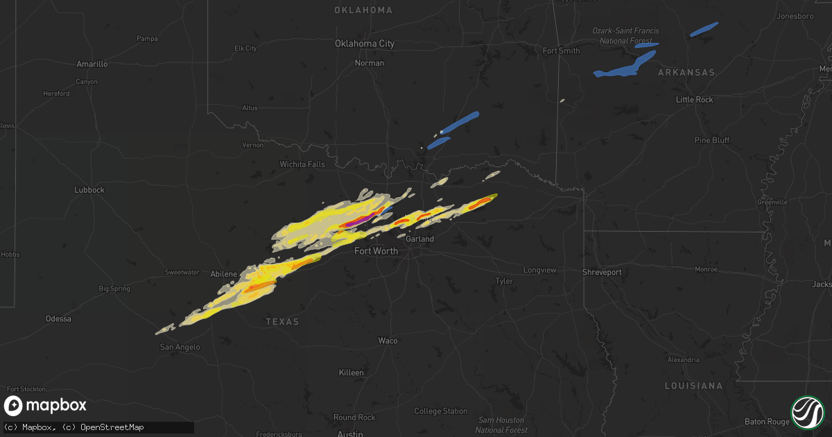
Hail Map on February 21, 2022
Get this storm
February 21 map
$229
one time, instant access
Download today. No call, no setup
Keep the $229
Bought the map and want the full workflow? Apply the entire $229 to a subscription within 7 days. None of it is wasted.
Every map, not just this one
This buys you this map. Subscription and you get every map we run, in the markets you choose from a few cities to whole states to nationwide. Plus real-time alerts the moment a storm fires.
Contact data
Name, contact info, occupancy, even credit band for addresses in the footprint. You go from where it hit to who to call.
Become the source they trust
Unlimited branding weather history reports on demand. You already have the documented answer ready for the property owner, and you are the one who showed up with it.
Property data and RoofTrace estimates
Pull up any address you have got, its value and the exact code rules for that jurisdiction, straight from One Click Code. Then RoofTrace estimates the squares, pitch, and roof value, priced the way you price.
Storm reports
Texas
| Date | Description |
|---|---|
| 02/21/20225:38 PM CST | Andrews mesonet. |
| 02/21/20225:00 AM CST | At 1059 PM CST, a severe thunderstorm was located 10 miles northeast of Decatur, moving east at 50 mph. HAZARD...Quarter size hail. SOURCE...Radar indicated. IMPACT...Damage to vehicles is possible. Locations impacted include... Denton, Gainesville, Sanger, Decatur, Krum, Pilot Point, Aubrey, Ray Roberts Park Isle Du Bois, Lake Kiowa, Ray Roberts Park Johnson Branch and Valley View.This includes Interstate 35 between mile markers 472 and 494. |
| 02/21/20224:25 AM CST | At 1025 PM CST, a severe thunderstorm was located near Chico, or 10 miles northwest of Bridgeport, moving northeast at 60 mph. HAZARD...60 mph wind gusts and quarter size hail. SOURCE...Radar indicated. IMPACT...Hail damage to vehicles is expected. Expect wind damage to roofs, siding, and trees. Locations impacted include... Decatur, Bridgeport, Alvord, Chico, Newport, Runaway Bay and Lake Bridgeport. |
| 02/21/20224:01 AM CST | At 1000 PM CST, a severe thunderstorm was located 8 miles northeast of Ranger, moving east at 55 mph. HAZARD...60 mph wind gusts and half dollar size hail. SOURCE...Radar indicated. IMPACT...Hail damage to vehicles is expected. Expect wind damage to roofs, siding, and trees. Locations impacted include... Mineral Wells, Graford, Gordon, Possum Kingdom State Park, Strawn and Mingus.This includes Interstate 20 between mile markers 374 and 389. |
| 02/21/20224:01 AM CST | Report from mping: ping pong ball |
| 02/21/20223:49 AM CST | Report from mping: ping pong ball |
| 02/21/20223:47 AM CST | Report from mping: half dollar |
| 02/21/20223:46 AM CST | Report from mping: quarter |
| 02/21/20223:46 AM CST | At 944 PM CST, a severe thunderstorm was located over Norton, moving northeast at 60 mph. HAZARD...60 mph wind gusts and quarter size hail. SOURCE...Radar indicated. IMPACT...Hail damage to vehicles is expected. Expect wind damage to roofs, siding, and trees. Locations impacted include... Winters, Lawn, Novice, Norton, Glen Cove, Hatchel, Silver Valley, Crews, Oplin, Wilmeth, Lake Coleman, Goldsboro, Lake Winters Lake and Ballinger Lake. |
| 02/21/20223:45 AM CST | Report from mping: half dollar |
| 02/21/20223:40 AM CST | Delayed report: trained spotter reported quarter |
| 02/21/20223:40 AM CST | At 939 PM CST, severe thunderstorms were located along a line extending from near Tye to near Lawn, moving northeast at 60 mph. HAZARD...60 mph wind gusts and nickel size hail. SOURCE...Radar indicated. IMPACT...Expect damage to roofs, siding, and trees. Locations impacted include... Abilene, Clyde, Albany, Baird, Wylie, Tye, Tuscola, Hawley, Buffalo Gap, Lawn, Moran, Putnam, Dudley, Caps, Dyess Afb, Eula, Potosi, View, Hamby and Impact.This includes Interstate 20 between Mile Markers 272 and 323. |
| 02/21/20223:38 AM CST | At 937 PM CST, a severe thunderstorm was located 15 miles north of Cisco, moving east at 50 mph. HAZARD...60 mph wind gusts and half dollar size hail. SOURCE...Radar indicated. IMPACT...Hail damage to vehicles is expected. Expect wind damage to roofs, siding, and trees. Locations impacted include... Breckenridge, Eastland, Cisco, Ranger, Necessity, Gunsight, Crystal Falls and Us-180 Near The Shackelford-Stephens County Line.This includes Interstate 20 between mile markers 324 and 352. |
| 02/21/20223:33 AM CST | At 933 PM CST, a severe thunderstorm was located near Graham, moving northeast at 50 mph. HAZARD...60 mph wind gusts and half dollar size hail. SOURCE...Radar indicated. IMPACT...Hail damage to vehicles is expected. Expect wind damage to roofs, siding, and trees. Locations impacted include... Graham, Jacksboro, Bryson and Newcastle. |
| 02/21/20223:32 AM CST | Report from mping: half dollar |
| 02/21/20223:30 AM CST | Report from mping: quarter |
| 02/21/20223:27 AM CST | Report from mping: quarter |
| 02/21/20223:26 AM CST | Report from mping: quarter |
| 02/21/20223:25 AM CST | Delayed report: quarter |
| 02/21/20223:25 AM CST | Report from mping: golf ball |
| 02/21/20223:24 AM CST | Report from mping: quarter |
| 02/21/20223:22 AM CST | 1.5 inch hail measured in lakewood village. |
| 02/21/20223:18 AM CST | Delayed report: quarter |
| 02/21/20223:05 AM CST | At 904 PM CST, a severe thunderstorm was located over Reno, or near Briar, moving east at 45 mph. HAZARD...60 mph wind gusts and quarter size hail. SOURCE...Radar indicated. IMPACT...Hail damage to vehicles is expected. Expect wind damage to roofs, siding, and trees. Locations impacted include... Azle, Briar, Reno, Springtown, Boyd, Cottondale and Sanctuary. |
| 02/21/20223:04 AM CST | At 903 PM CST, a severe thunderstorm was located over Briar, moving east at 55 mph. HAZARD...60 mph wind gusts and quarter size hail. SOURCE...Radar indicated. IMPACT...Hail damage to vehicles is expected. Expect wind damage to roofs, siding, and trees. Locations impacted include... Plano, McKinney, Carrollton, Frisco, Denton, Lewisville, Allen, Flower Mound, Grapevine, Keller, The Colony, Southlake, Corinth, Highland Village, Azle, Trophy Club, Lake Dallas, Eagle Mountain, Lake Lewisville and Briar.This includes the following highways... Interstate 35 between mile markers 468 and 471. Interstate 35W between mile markers 63 and 85. Interstate 35E between mile markers 448 and 466. |
| 02/21/20222:42 AM CST | At 842 PM CST, a severe thunderstorm was located 7 miles northwest of Gordon, or 14 miles northeast of Ranger, moving east at 55 mph. HAZARD...60 mph wind gusts and half dollar size hail. SOURCE...Radar indicated. IMPACT...Hail damage to vehicles is expected. Expect wind damage to roofs, siding, and trees. Locations impacted include... Weatherford, Mineral Wells, Willow Park, Hudson Oaks, Annetta, Graford, Gordon, Cool, Poolville, Mineral Wells State Park, Strawn, Annetta South, Annetta North, Millsap and Mingus.This includes Interstate 20 between mile markers 373 and 416. |
| 02/21/20222:21 AM CST | At 821 PM CST, a severe thunderstorm was located 7 miles south of Graford, or 11 miles west of Mineral Wells, moving east at 45 mph. HAZARD...60 mph wind gusts and nickel size hail. SOURCE...Radar indicated. IMPACT...Expect damage to roofs, siding, and trees. Locations impacted include... Weatherford, Mineral Wells, Azle, Briar, Willow Park, Reno, Aledo, Springtown, Hudson Oaks, Annetta, Boyd, Graford, Cool, Poolville, Cottondale, Mineral Wells State Park, Annetta South, Annetta North, Millsap and Sanctuary. |
| 02/21/20222:19 AM CST | At 818 PM CST, a severe thunderstorm was located near Atwell, or 13 miles southwest of Cisco, moving northeast at 55 mph. HAZARD...Half dollar size hail. SOURCE...Radar indicated. IMPACT...Damage to vehicles is possible. Locations impacted include... Eastland, Cisco, Ranger, Necessity, Gunsight and Strawn. This includes Interstate 20 between mile markers 324 and 363. |
| 02/21/20222:15 AM CST | At 813 PM CST, a severe thunderstorm was located near New Fairview, or 7 miles southeast of Decatur, moving east at 50 mph. HAZARD...Half dollar size hail. SOURCE...Radar indicated. IMPACT...Damage to vehicles is possible. Locations impacted include... McKinney, Frisco, Denton, Sherman, Corinth, Sanger, Prosper, Celina, Krum, Pilot Point, Argyle, Shady Shores, Aubrey, Northlake, Krugerville, Cross Roads, Gunter, New Fairview, Dorchester and Ray Roberts Park Isle Du Bois. |
| 02/21/20222:02 AM CST | At 802 PM CST, a severe thunderstorm was located near Rowden, moving northeast at 55 mph. HAZARD...60 mph wind gusts and quarter size hail. SOURCE...Radar indicated. IMPACT...Hail damage to vehicles is expected. Expect wind damage to roofs, siding, and trees. Locations impacted include... Putnam, Rowden, Atwell, Admiral, Us-283 Near The Coleman- Callahan County Line and I-20 Near The Callahan- Eastland County Line.This includes Interstate 20 between Mile Markers 311 and 323. |
| 02/21/20221:35 AM CST | At 734 PM CST, a severe thunderstorm was located 11 miles northeast of Graford, or 14 miles south of Jacksboro, moving east at 50 mph. HAZARD...60 mph wind gusts and quarter size hail. SOURCE...Radar indicated. IMPACT...Hail damage to vehicles is expected. Expect wind damage to roofs, siding, and trees. Locations impacted include... Decatur, Bridgeport, Briar, Pecan Acres, Springtown, New Fairview, Aurora, Boyd, Paradise, Poolville, Cottondale, Boonsville, Rhome, Runaway Bay, Newark and Lake Bridgeport. |
| 02/20/202210:18 PM CST | Social media report. |
| 02/20/20229:48 PM CST | A local report indicates 1.00 inch wind near 1 NNW GRAHAM |
| 02/20/20229:05 PM CST | Report from mping: ping pong ball |
| 02/20/20228:57 PM CST | A local report indicates 1.00 inch wind near 2 W SPRINGTOWN |
| 02/20/20228:45 PM CST | A local report indicates 1.00 inch wind near 3 S POOLVILLE |
| 02/20/20228:31 PM CST | A local report indicates 58 MPH wind near MINERAL WELLS |
| 02/20/20228:30 PM CST | Golf ball hail jackson rd and highway 380. |
| 02/20/20228:29 PM CST | Report from mping: ping pong ball |
| 02/20/20228:21 PM CST | Report from mping: quarter |
| 02/20/20228:17 PM CST | Numerous houses in heritage creek north subdivision lost windows on west side from large hail. |
| 02/20/20228:17 PM CST | Numerous houses in the heritage creek north subdivision lost windows on the west side fron large hail. |
| 02/20/20228:03 PM CST | A local report indicates 1.50 inch wind near PARADISE |
| 02/20/20228:00 PM CST | 2.125 inch hail measured. Time estimated. |
| 02/20/20227:56 PM CST | A local report indicates 1.00 inch wind near 4 W COTTONDALE |
Missouri
| Date | Description |
|---|---|
| 02/21/20225:55 AM CST | Small portion of large metal building collapsed with many of the roof metal sheets blown off. Several houses/buildings with some shingles blown off. Minor tree damage w |
| 02/21/20225:54 AM CST | A few outbuildings had shingles removed from their roofs. Large barns suffered roof damage. Minor siding and roof damage to a few homes. A few large tree limbs downed. |
| 02/21/20225:32 AM CST | Roof blown off a building on highway 25 just north of malden. |
| 02/21/20225:31 AM CST | Tree fell onto house off highway j. Additionally... A motorist driving down highway j had a tree fall on their car. No injuries. |
| 02/21/20225:30 AM CST | 8-10 inch diameter tree... 20 feet long... Fallen onto hwy u. |
| 02/21/20225:24 AM CST | Multiple trees down on highway ww just north of campbell. |
| 02/21/20225:12 AM CST | An nws storm damage survey found a microburst with winds of 80 to 90 mph struck southeast butler county early tuesday morning between 512 and 518 am cst. The microburst |
Arkansas
| Date | Description |
|---|---|
| 02/21/20225:55 AM CST | Multiple trees/limbs down in roads. |
| 02/21/20225:55 AM CST | Large tree down at stanford in road. |
| 02/21/20225:53 AM CST | At 1153 PM CST, severe thunderstorms were located along a line extending from 4 miles southwest of Howe to 4 miles south of Heavener to 3 miles south of Big Cedar, moving northeast at 45 mph. HAZARD...60 mph wind gusts and penny size hail. SOURCE...Radar indicated. IMPACT...Expect damage to roofs, siding, and trees. Locations in or near the path include... Poteau... Heavener... Wister... Howe... Hartford... Huntington... Midland... Heavener Runestone State Park... Big Cedar... Lake Wister State Park... Patterson... Arkola... Crossroads... Witcherville... Dayton... Hodgen... |
| 02/21/20225:27 AM CST | Report from cross co sherriff: tree has fallen across hwy near us 64 & 64b. Semi truck crashed into said tree. |
| 02/21/20225:20 AM CST | Multiple trees/limbs down in roads. |
| 02/21/20225:06 AM CST | Large tree down at stanford in road. |
| 02/21/20224:58 AM CST | Report of a tree that has fallen on a house in sedgwick... Ar. |
| 02/21/20224:57 AM CST | A roof partially blown off of a mobile home and several trees and power lines down on cypress street in sedgwick... Ar. |
| 02/21/20224:54 AM CST | Several trees down on roads and a house. |
| 02/21/20224:35 AM CST | Roof blown off two houess in maynard. |
| 02/21/20224:30 AM CST | Roof blown off a duplex in biggers. |
| 02/21/20224:30 AM CST | Tree fell on house north of pocahontas. Also roof blown off factory building in pocahontas. Numerous power lines are down. |
| 02/21/20224:13 AM CST | Multiple trees down in batesville... Ar. |
| 02/21/20223:50 AM CST | Several trees down across northern parts of cleburne county. |
| 02/21/20223:45 AM CST | A few large trees down in the area. |
| 02/21/20223:34 AM CST | Multiple trees down in clinton... Ar and several homes without power. |
| 02/21/20223:05 AM CST | Media report of multiple trees and powerlines down. |
| 02/21/20223:03 AM CST | Highway 7 and east h street in russellville... Ar blocked by downed power lines. |
| 02/21/20223:02 AM CST | Roof torn off of barn in hector... Ar. Roof debris is blocking pine street. |
| 02/21/20222:55 AM CST | A few large trees down in the area. One home was damaged by a snapped tree. |
Oklahoma
| Date | Description |
|---|---|
| 02/21/20224:32 AM CST | At 1032 PM CST, a severe thunderstorm was located near Clayton Lake State Park, moving northeast at 45 mph. HAZARD...60 mph wind gusts and quarter size hail. SOURCE...Radar indicated. IMPACT...Hail damage to vehicles is expected. Expect wind damage to roofs, siding, and trees. Locations in or near the path include... Clayton... Talihina... Albion... Clayton Lake State Park... Talimena State Park... Bengal... Tuskahoma... Yanush... Nashoba... Kiamichi... Whitesboro... Muse... Sardis... Honobia... |
| 02/21/20223:36 AM CST | At 936 PM CST, a severe thunderstorm was located 9 miles east of Stringtown, moving northeast at 45 mph. HAZARD...70 mph wind gusts and quarter size hail. SOURCE...Radar indicated. IMPACT...Hail damage to vehicles is expected. Expect considerable tree damage. Wind damage is also likely to mobile homes, roofs, and outbuildings. Locations in or near the path include... Clayton... Hartshorne... Clayton Lake State Park... Stanley... Dunbar... Haileyville... Sardis... Dow... |
| 02/21/20222:38 AM CST | At 838 PM CST, severe thunderstorms were located along a line extending from near Coleman to 3 miles west of Little City, moving northeast at 50 mph. HAZARD...70 mph wind gusts and quarter size hail. SOURCE...Radar indicated. IMPACT...Hail damage to vehicles is expected. Expect considerable tree damage. Wind damage is also likely to mobile homes, roofs, and outbuildings. Locations impacted include... Durant, Madill, Atoka, Caddo, Wapanucka, Stringtown, Lehigh, Silo, Milburn, Tushka, Caney, Kenefic, Mead, Armstrong, Fillmore, Lane, Woodville, Coleman, Daisy and Little City. |
Cities Impacted by Hail Map on February 21, 2022
- Jacksboro, TX
- Commerce, TX
- Klondike, TX
- Ladonia, TX
- Pecan Gap, TX
- Enloe, TX
- Cooper, TX
- Lake Creek, TX
- Wolfe City, TX
- Greenville, TX
- Farmersville, TX
- Celeste, TX
- Perrin, TX
- Graford, TX
- Moran, TX
- Rhome, TX
- Decatur, TX
- Era, TX
- Muenster, TX
- Alvord, TX
- Rosston, TX
- Sunset, TX
- Saint Jo, TX
- Forestburg, TX
- Winters, TX
- Strawn, TX
- Ranger, TX
- Paris, TX
- Powderly, TX
- Mineral Wells, TX
- Breckenridge, TX
- Graham, TX
- Allen, TX
- Princeton, TX
- Cisco, TX
- Paradise, TX
- Wylie, TX
- Poolville, TX
- Weatherford, TX
- Palo Pinto, TX
- Cross Plains, TX
- Gordon, TX
- Novice, TX
- Eastland, TX
- Clyde, TX
- Rising Star, TX
- Coleman, TX
- Abilene, TX
- Burkett, TX
- Baird, TX
- Goldsboro, TX
- Atoka, OK
- Coleman, OK
- Kenefic, OK
- Mckinney, TX
- Plano, TX
- Lawn, TX
- Ovalo, TX
- Springtown, TX
- Newark, TX
- Haslet, TX
- Sanger, TX
- Krum, TX
- Bridgeport, TX
- Bryson, TX
- Chico, TX
- Bowie, TX
- Lake Dallas, TX
- Frisco, TX
- Lewisville, TX
- Little Elm, TX
- Argyle, TX
- Flower Mound, TX
- South Bend, TX
- Ponder, TX
- Boyd, TX
- Shabbona, IL
- Waterman, IL
- Lee, IL
- Ravenna, TX
- Savoy, TX
- Carlsbad, TX
- Robert Lee, TX
- Millsap, TX
- Justin, TX
- Maple Park, IL
- Dekalb, IL
- Prosper, TX
- Bronte, TX
- Norton, TX
- Roanoke, TX
- Fort Worth, TX
- Denton, TX
- Ballinger, TX
- Santo, TX
- The Colony, TX
- Anna, TX
- Whitt, TX
- Melissa, TX
- Blue Ridge, TX
- Carrollton, TX
- Leonard, TX
- Valley View, TX
- Azle, TX
- Gainesville, TX
- Dallas, TX
- Tuscola, TX
- Sumner, TX
- Tioga, TX
- Coppell, TX
- Irving, TX
- Keller, TX
- Bonham, TX
- Albany, TX
- Howe, TX
- Pilot Point, TX
- Whitesboro, TX
- Collinsville, TX
- Madill, OK
- Paw Paw, IL
- Bells, TX
- Gunter, TX
- Trenton, TX
- Danville, AR
- Booneville, AR
- Russellville, AR
- Havana, AR
- Pottsville, AR
- Dardanelle, AR
- Belleville, AR
- Atkins, AR
- Dover, AR
- Hector, AR
- Shirley, AR
- Prim, AR
- Drasco, AR
- Edgemont, AR
- Mountain View, AR
- Fairfield Bay, AR
- Caruthersville, MO
- Hayti, MO
- Gobler, MO
- Steele, MO
- Bragg City, MO
- Cooter, MO
- Durant, OK
- Milburn, OK
- Caney, OK
- Caddo, OK
- Daisy, OK
- Stringtown, OK
- Aubrey, TX
- Pattonville, TX