Hail Map in Kansas City, MO on February 19, 2014
The weather event in Kansas City, MO on February 19, 2014 includes Hail map. 3 states and 35 cities were impacted and suffered possible damage. The total estimated number of properties impacted is 28,798.
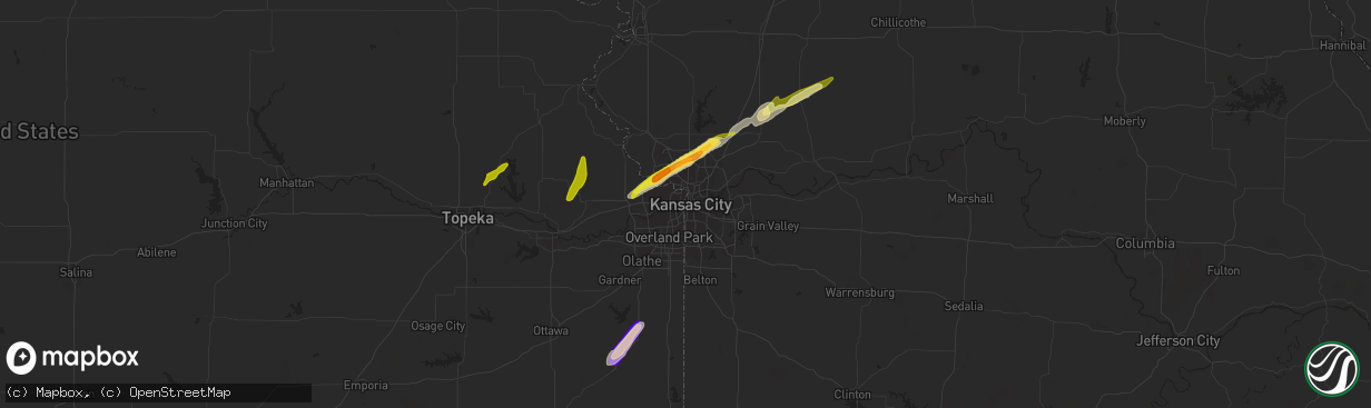
Hail
28,798
Estimated number of impacted properties by a 1.00" hail or larger0
Estimated number of impacted properties by a 1.75" hail or larger0
Estimated number of impacted properties by a 2.50" hail or largerStorm reports in Kansas City, MO
Kansas City, MO
| Date | Description |
|---|---|
| 02/19/20144:58 AM CST | A local report indicates 1.00 inch wind near 4 N GLADSTONE |
| 02/19/20144:55 AM CST | Near staley high school in kc north |
| 02/19/20144:54 AM CST | Hail up to quarter size covering the ground near zona rosa |
| 02/19/20144:45 AM CST | Picture posted on social media from public |
All Cities Impacted by Hail Map on February 19, 2014
- Osawatomie, KS
- Paola, KS
- Cowgill, MO
- Polo, MO
- Kearney, MO
- Holt, MO
- Kansas City, KS
- Smithville, MO
- Liberty, MO
- Kansas City, MO
- Braymer, MO
- Ludlow, MO
- Valley Falls, KS
- Ozawkie, KS
- Lane, KS
- Lawson, MO
- Weston, MO
- Leavenworth, KS
- Fontana, KS
- De Kalb, MO
- Rantoul, KS
- Meriden, KS
- Topeka, KS
- Tonganoxie, KS
- Easton, KS
- McLouth, KS
- Signal Mountain, TN
- Whitwell, TN
- Dunlap, TN
- White Pine, TN
- Newport, TN
- Dandridge, TN
- La Cygne, KS
- Pleasanton, KS
- Mound City, KS


