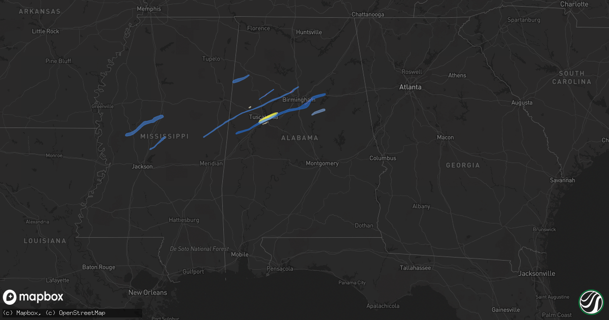
Hail Map in Alabama on February 17, 2022
Get this storm
February 17 map
$229
one time, instant access
Download today. No call, no setup
Keep the $229
Bought the map and want the full workflow? Apply the entire $229 to a subscription within 7 days. None of it is wasted.
Every map, not just this one
This buys you this map. Subscription and you get every map we run, in the markets you choose from a few cities to whole states to nationwide. Plus real-time alerts the moment a storm fires.
Contact data
Name, contact info, occupancy, even credit band for addresses in the footprint. You go from where it hit to who to call.
Become the source they trust
Unlimited branding weather history reports on demand. You already have the documented answer ready for the property owner, and you are the one who showed up with it.
Property data and RoofTrace estimates
Pull up any address you have got, its value and the exact code rules for that jurisdiction, straight from One Click Code. Then RoofTrace estimates the squares, pitch, and roof value, priced the way you price.
Storm reports in Alabama
Alabama
| Date | Description |
|---|---|
| 02/17/20225:45 PM CST | Tree on a home. |
| 02/17/20224:55 PM CST | Multiple trees and power lines down. Possible tornado. |
| 02/17/20224:54 PM CST | Trees snapped along al hwy 5. Possible tornado. |
| 02/17/20224:53 PM CST | 18 wheeler blown over on interstate 22. Possible tornado. |
| 02/17/20224:18 PM CST | Trees in roadway and structural damage reported. |
| 02/17/20224:14 PM CST | Pronounced tds evident on radar in northern tuscaloosa county. |
| 02/17/20224:00 PM CST | Pine tree uprooted and fell on a corner of a home. |
| 02/17/20223:34 PM CST | Barn roof damaged. Possible tornado. |
| 02/17/20221:50 AM CST | At 750 PM CST, severe thunderstorms were located along a line extending from near Piedmont to near Fort McClellan, moving east at 55 mph. HAZARD...60 mph wind gusts. SOURCE...Radar indicated. IMPACT...Expect damage to roofs, siding, and trees. Locations impacted include... Anniston, Jacksonville, Piedmont, Fort McClellan, Fruithurst, Edwardsville, Muscadine, Pleasant Gap, Mars Hills, Sweetwater Lake, Coleman Lake And Campground, Spring Garden, Liberty Hill, Oak Level and Borden Springs. |
| 02/17/20221:32 AM CST | At 732 PM CST, a severe thunderstorm was located over Shelby County Airport, or near Calera, moving east at 50 mph. HAZARD...60 mph wind gusts. SOURCE...Radar indicated. IMPACT...Expect damage to roofs, siding, and trees. Locations impacted include... Alabaster, Pelham, Calera, Montevallo, Childersburg, Columbiana, Wilsonville, Vincent, Harpersville, Wilton, American Village, Maylene, University Of Montevallo, Shelby County Airport, Lay Lake, Shelby, Shelby Shores, Kelley Branch, Camp Branch and Siluria. |
| 02/16/202211:28 PM CST | At 527 PM CST, a severe thunderstorm was located near Brookwood, or 14 miles east of Holt, moving northeast at 65 mph. HAZARD...60 mph wind gusts and quarter size hail. SOURCE...Radar indicated. IMPACT...Hail damage to vehicles is expected. Expect wind damage to roofs, siding, and trees. Locations impacted include... Birmingham, Hoover, Vestavia Hills, Alabaster, Bessemer, Homewood, Pelham, Mountain Brook, Helena, Hueytown, Irondale, Leeds, Fairfield, Chelsea, Fultondale, Pleasant Grove, Tarrant, Midfield, Adamsville and Brighton. |
| 02/16/20227:01 PM CST | Tree on house. |
| 02/16/20226:20 PM CST | Corrects previous tornado report from 1 s leeds. Tree on mobile home with entrapment. |
| 02/16/20226:20 PM CST | Tree down. |
| 02/16/20226:19 PM CST | Hwy 25 blocked by trees down. Possible tornado. |
| 02/16/20226:13 PM CST | Tree down. |
| 02/16/20226:07 PM CST | Road blocked by trees. |
| 02/16/20226:05 PM CST | Power outage reported in the skyline area. |
| 02/16/20226:03 PM CST | Tree on house. Possible tornado. |
| 02/16/20226:00 PM CST | Power outage was reported in the skyline area. A power pole was broken in this area. |
All States Impacted by Hail Map on February 17, 2022
Cities Impacted by Hail Map on February 17, 2022
- Cottondale, AL
- Tuscaloosa, AL
- Brookwood, AL
- Fosters, AL
- Duncanville, AL
- Hagarville, AR
- Lamar, AR
- Gordo, AL
- Yazoo City, MS
- West, MS
- Durant, MS
- Lexington, MS
- Kosciusko, MS
- Canton, MS
- Camden, MS
- Mulga, AL
- Mount Olive, AL
- Shuqualak, MS
- Coker, AL
- Reform, AL
- Carrollton, AL
- Macon, MS
- Northport, AL
- Bessemer, AL
- Aliceville, AL
- Quinton, AL
- Elrod, AL
- Oakman, AL
- Graysville, AL
- Adamsville, AL
- De Kalb, MS
- Preston, MS
- Gardendale, AL
- Morris, AL
- Echola, AL
- Buhl, AL
- Adger, AL
- Guin, AL
- Sulligent, AL
- Beaverton, AL
- Berry, AL
- Parrish, AL
- McCalla, AL
- Moody, AL
- Odenville, AL
- Eutaw, AL
- Vance, AL
- Riverside, AL
- Leeds, AL
- Ralph, AL
- Sterrett, AL
- Pelham, AL
- Knoxville, AL
- Boligee, AL
- Birmingham, AL
- Pell City, AL
- Alpine, AL
- Wilsonville, AL
- Harpersville, AL
- Childersburg, AL
- Wartrace, TN
- Unionville, TN
- Woodbury, TN
- Beechgrove, TN
- Bell Buckle, TN
- Christiana, TN
- Bradyville, TN
- Manchester, TN
- Shelbyville, TN
- Louisville, TN
- Rockford, TN
- Maryville, TN
- Alcoa, TN
- Knoxville, TN
- Munfordville, KY
- Bonnieville, KY
- Summersville, KY
- Mount Sherman, KY
- Magnolia, KY
- Garwood, NJ
- Roselle Park, NJ
- Newark, NJ
- Jersey City, NJ
- Mountainside, NJ
- Far Rockaway, NY
- Brooklyn, NY
- Hillside, NJ
- Bayonne, NJ
- Union, NJ
- Roselle, NJ
- Rockaway Park, NY
- Westfield, NJ
- Kenilworth, NJ
- Arverne, NY
- Linden, NJ
- Staten Island, NY
- Springfield, NJ
- Elizabeth, NJ
- Elizabethport, NJ
- Cranford, NJ


