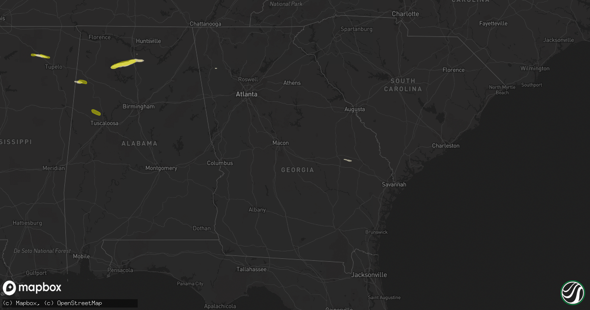
Hail Map in Georgia on February 8, 2017
Get this storm
February 8 map
$229
one time, instant access
Download today. No call, no setup
Keep the $229
Bought the map and want the full workflow? Apply the entire $229 to a subscription within 7 days. None of it is wasted.
Every map, not just this one
This buys you this map. Subscription and you get every map we run, in the markets you choose from a few cities to whole states to nationwide. Plus real-time alerts the moment a storm fires.
Contact data
Name, contact info, occupancy, even credit band for addresses in the footprint. You go from where it hit to who to call.
Become the source they trust
Unlimited branding weather history reports on demand. You already have the documented answer ready for the property owner, and you are the one who showed up with it.
Property data and RoofTrace estimates
Pull up any address you have got, its value and the exact code rules for that jurisdiction, straight from One Click Code. Then RoofTrace estimates the squares, pitch, and roof value, priced the way you price.
Storm reports in Georgia
Georgia
| Date | Description |
|---|---|
| 02/08/20173:03 AM CST | National weather service survey team determined that the ongoing tornado damaged additional small trees before lifting just east of highway 17 near pineora. The tornado |
| 02/08/20173:02 AM CST | Public witnessed a tornado along floyd avenue. The tornado destroyed a pumphouse and damaged carports. Numerous trees and power lines were blown down. |
| 02/08/20173:01 AM CST | National weather service survey team determined that a tornado crossed the ogeechee river from bulloch county into effingham county. The tornado produced mainly ef-1 da |
| 02/08/20173:01 AM CST | Effingham county 911 center reported many trees blown down onto honey ridge road. This was a possible tornado. |
| 02/08/20172:57 AM CST | *** 2 inj *** national weather service survey team reported continued tornado damage just southeast of the south old river road...terrell road and little hagan road are |
| 02/08/20172:56 AM CST | *** 5 inj *** national weather service survey team determined that a tornado attained ef-2 intensity with estimated maximum wind speeds of 130 mph just west of south ol |
| 02/08/20172:56 AM CST | *** 7 inj *** bulloch county 911 center reported at least 3 to 4 residences damaged or destroyed along old river road south and lillie hagan road. This was a possible t |
| 02/08/20172:51 AM CST | National weather service survey team determined the initial touchdown of a tornado near stillson leefield road in eastern bulloch county. Many trees were snapped and up |
All States Impacted by Hail Map on February 8, 2017
Cities Impacted by Hail Map on February 8, 2017
- New Albany, MS
- Blue Springs, MS
- Wilder, TN
- Jamestown, TN
- Robbins, TN
- Huntsville, TN
- Allardt, TN
- Helenwood, TN
- Falkville, AL
- Addison, AL
- New Tazewell, TN
- Tazewell, TN
- Oneida, TN
- Winfield, TN
- Eva, AL
- Hartselle, AL
- Houston, AL
- Haleyville, AL
- Double Springs, AL
- Vinemont, AL
- Danville, AL
- Rome, GA
- Sulligent, AL
- Beaverton, AL
- Somerville, AL
- Twin City, GA
- Metter, GA
- Myrtle, MS
- Detroit, AL
- Pioneer, TN
- Fuquay Varina, NC
- Willow Spring, NC
- Angier, NC
- Guin, AL
- Etta, MS
- Moulton, AL
- Northport, AL
- Elrod, AL
- Coker, AL
- Kennedy, AL
- Fayette, AL


