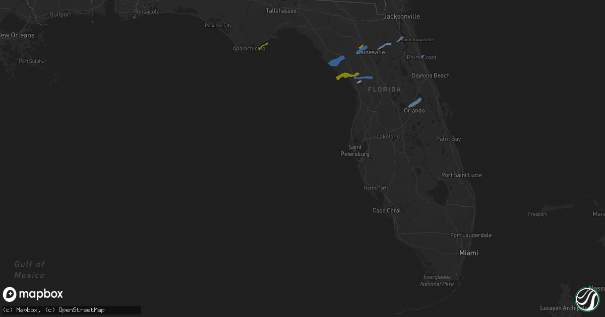
Hail Map in Florida on February 6, 2021
Get this storm
February 6 map
$229
one time, instant access
Download today. No call, no setup
Keep the $229
Bought the map and want the full workflow? Apply the entire $229 to a subscription within 7 days. None of it is wasted.
Every map, not just this one
This buys you this map. Subscription and you get every map we run, in the markets you choose from a few cities to whole states to nationwide. Plus real-time alerts the moment a storm fires.
Contact data
Name, contact info, occupancy, even credit band for addresses in the footprint. You go from where it hit to who to call.
Become the source they trust
Unlimited branding weather history reports on demand. You already have the documented answer ready for the property owner, and you are the one who showed up with it.
Property data and RoofTrace estimates
Pull up any address you have got, its value and the exact code rules for that jurisdiction, straight from One Click Code. Then RoofTrace estimates the squares, pitch, and roof value, priced the way you price.
Storm reports in Florida
Florida
| Date | Description |
|---|---|
| 02/06/20215:50 PM CST | Trees were damaged in the virginia village area of clay county. The time of the damage was based on radar imagery. |
| 02/06/20215:45 PM CST | Emergency manager reported minor damage to one home and light to moderate tree damage in the area of keystone heights. Time estimate based on radar. |
| 02/06/20214:10 PM CST | Media relayed report of one quarter inch hail in the city of alachua. |
| 02/06/20213:38 PM CST | Public reports fence damage to several homes near the intersection of 79th street and 100 ave in vero lakes estates... Along with some backyard items thrown about. Poss |
| 02/06/20213:20 PM CST | Two homes received minor to moderate roof damage. Multiple trees and powerlines down between chiefland and fanning springs. |
| 02/06/20216:56 AM CST | At 1256 PM EST, a severe thunderstorm was located 8 miles east of Eastpoint, moving northeast at 55 mph. HAZARD...60 mph wind gusts and quarter size hail. SOURCE...Radar indicated. IMPACT...Hail damage to vehicles is expected. Expect wind damage to roofs, siding, and trees. Locations impacted include... Carrabelle, Carrabelle Beach, Alligator Point, Saint Teresa, Turkey Point, Bald Point, Royal Bluff, Mcintyre, Yent Place, Lanark Village, St George Island St Pk and Green Point. |
| 02/06/20212:39 AM CST | At 839 PM EST, severe thunderstorms were located along a line extending from 8 miles east of San Mateo to 6 miles east of Andalusia to 8 miles southwest of Bunnell, moving east at 55 mph. HAZARD...60 mph wind gusts. SOURCE...Radar indicated. IMPACT...Expect damage to roofs, siding, and trees. Locations impacted include... Palm Coast, Flagler Beach, Bunnell, Marineland, Beverly Beach and Espanola. |
| 02/06/202112:53 AM CST | At 653 PM EST, a severe thunderstorm was located near Williston Highlands, or 7 miles northwest of Rainbow Lakes Estates, moving east at 45 mph. HAZARD...60 mph wind gusts and quarter size hail. SOURCE...Radar indicated. IMPACT...Hail damage to vehicles is expected. Expect wind damage to roofs, siding, and trees. Locations impacted include... Ocala, Rainbow Lakes Estates, Citra, Sparr, Anthony, Ocala Airport, Reddick, McIntosh, Flemington and Lowell. |
| 02/06/202112:41 AM CST | At 641 PM EST, a severe thunderstorm was located 11 miles southwest of Williston Highlands, or 14 miles west of Rainbow Lakes Estates, moving east at 50 mph. HAZARD...60 mph wind gusts and penny size hail. SOURCE...Radar indicated. IMPACT...Expect damage to roofs, siding, and trees. Locations impacted include... Williston, Williston Highlands, Williston Municipal Airport and Lebanon. |
| 02/06/202112:16 AM CST | At 615 PM EST, a severe thunderstorm was located 14 miles south of Fowlers Bluff, or 21 miles south of Chiefland, moving northeast at 50 mph. HAZARD...60 mph wind gusts and penny size hail. SOURCE...Radar indicated. IMPACT...Expect damage to roofs, siding, and trees. Locations impacted include... Otter Creek. |
| 02/06/202112:07 AM CST | At 607 PM EST, a severe thunderstorm was located near Bunnell, moving northeast at 40 mph. HAZARD...60 mph wind gusts and penny size hail. SOURCE...Radar indicated. IMPACT...Expect damage to roofs, siding, and trees. Locations impacted include... Palm Coast, Flagler Beach, Bunnell, Marineland and Beverly Beach. |
| 02/05/202110:59 PM CST | At 459 PM EST, a severe thunderstorm was located near High Springs, or 13 miles east of Bell, moving northeast at 55 mph. HAZARD...60 mph wind gusts and quarter size hail. SOURCE...Radar indicated. IMPACT...Hail damage to vehicles is expected. Expect wind damage to roofs, siding, and trees. Locations impacted include... Starke, Trenton, Lake Butler, Bell, Raiford, Worthington Spring, Alachua, High Springs, Worthington Springs and Groves. |
| 02/05/20217:45 PM CST | Emergency manager relayed a report from fcso of a tree down on woodhaven drive near us1 in palm coast. |
| 02/05/20217:40 PM CST | Emergency manager reported wires down near the intersection of sr100 and betra rd and sr 100 and water oak rd in the neighborhood of daytona north. |
| 02/05/20217:35 PM CST | Emergency manager reported wires down near the intersection of sr100 and betra rd and sr 100 and water oak rd in the neighborhood of daytona north. |
Cities Impacted by Hail Map on February 6, 2021
- Inglis, FL
- Fitzgerald, GA
- Wray, GA
- Eastpoint, FL
- Carrabelle, FL
- Cedar Key, FL
- Morriston, FL
- Alachua, FL
- Newberry, FL
- Gainesville, FL
- Palm Coast, FL
- Dunnellon, FL
- Ocala, FL
- Chiefland, FL
- Horseshoe Beach, FL
- Old Town, FL
- Trenton, FL
- Waldo, FL
- Melrose, FL
- Florahome, FL
- Earleton, FL
- Keystone Heights, FL
- Hawthorne, FL
- Green Cove Springs, FL
- Winter Springs, FL
- Ocoee, FL
- Sanford, FL
- Altamonte Springs, FL
- Lake Mary, FL
- Longwood, FL
- Apopka, FL
- Casselberry, FL
- Maitland, FL
- Orlando, FL


