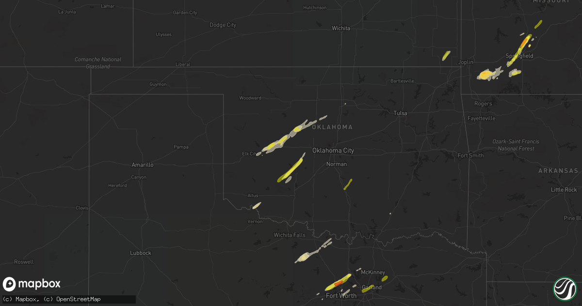
Hail Map in Oklahoma on February 6, 2019
Get this storm
February 6 map
$229
one time, instant access
Download today. No call, no setup
Keep the $229
Bought the map and want the full workflow? Apply the entire $229 to a subscription within 7 days. None of it is wasted.
Every map, not just this one
This buys you this map. Subscription and you get every map we run, in the markets you choose from a few cities to whole states to nationwide. Plus real-time alerts the moment a storm fires.
Contact data
Name, contact info, occupancy, even credit band for addresses in the footprint. You go from where it hit to who to call.
Become the source they trust
Unlimited branding weather history reports on demand. You already have the documented answer ready for the property owner, and you are the one who showed up with it.
Property data and RoofTrace estimates
Pull up any address you have got, its value and the exact code rules for that jurisdiction, straight from One Click Code. Then RoofTrace estimates the squares, pitch, and roof value, priced the way you price.
Storm reports in Oklahoma
Oklahoma
| Date | Description |
|---|---|
| 02/06/20195:42 AM CST | At 1141 PM CST, a severe thunderstorm was located 4 miles west of Tipton, moving northeast at 60 mph. HAZARD...Quarter size hail and the potential for a large amount of smaller hail. SOURCE...Radar indicated. IMPACT...Damage to vehicles is expected. Locations impacted include... Snyder, Tipton, Mountain Park, Medicine Park, Indiahoma, Manitou, Headrick, Cooperton, Meers, Tom Steed Reservoir, Lake Lawtonka, Boone, Humphreys, southwestern Lake Ellsworth, southwestern Fort Sill, Wichita Mountains Wildlife Refuge and Hess. |
| 02/06/20194:24 AM CST | At 1023 PM CST, a severe thunderstorm was located near Cogar, moving northeast at 65 mph. HAZARD...Quarter size hail and the potential for a large amount of smaller hail. SOURCE...Radar indicated. IMPACT...Damage to vehicles is expected. Locations impacted include... Northwestern Oklahoma City, El Reno, Yukon, Piedmont, Concho, Cedar Lake and Richland. |
| 02/06/20193:51 AM CST | At 950 PM CST, a severe thunderstorm was located 9 miles northwest of Boone, moving northeast at 60 mph. HAZARD...Quarter size hail. SOURCE...Radar indicated. IMPACT...Damage to vehicles is expected. Locations impacted include... Anadarko, Tuttle, Union City, Minco, Binger, Fort Cobb, Gracemont, Cogar, Albert, Lake Chickasha, Fort Cobb Reservoir and Cedar Lake. |
| 02/06/20193:15 AM CST | Reported tree down blocking roadway on bullard chapel road 1/2 mile south of harbert road. Time based on radar estimate. |
| 02/06/20193:00 AM CST | Two large trees downed blocking driveway. |
| 02/06/20192:14 AM CST | Strong thunderstorm wind uprooted trees |
| 02/06/20192:13 AM CST | Strong thunderstorm wind uprooted trees...damaged the roof of a home...and destroyed outbuildings. |
| 02/06/20191:28 AM CST | At 726 PM CST, a severe thunderstorm was located 8 miles southeast of Fay, moving northeast at 45 mph. HAZARD...Quarter size hail and the potential for a large of amount of smaller hail. SOURCE...Radar indicated. IMPACT...Damage to vehicles is expected. Locations impacted include... Watonga, Kingfisher, Hitchcock, Greenfield, Loyal and Omega. |
| 02/06/201912:45 AM CST | At 645 PM CST, a severe thunderstorm was located 5 miles west of Clinton, moving northeast at 45 mph. HAZARD...Quarter size hail. SOURCE...Radar indicated. IMPACT...Damage to vehicles is expected. Locations impacted include... Weatherford, Clinton, Thomas, Arapaho, Custer City and Stafford. |
| 02/05/20199:03 PM CST | At 258 PM CST, a severe thunderstorm was located near Paden, moving northeast at 60 mph. HAZARD...60 mph wind gusts and quarter size hail. SOURCE...Radar indicated. IMPACT...Hail damage to vehicles is expected. Expect wind damage to roofs, siding, and trees. Locations in or near the path include... Bristow... Boley... Paden... Slick... Welty... Mason...This includes Interstate 44 between mile markers 190 and 192. |
| 02/05/20197:57 PM CST | At 156 PM CST, a severe thunderstorm was located 4 miles southeast of Rosedale, moving northeast at 45 mph. HAZARD...60 mph wind gusts and quarter size hail. SOURCE...Radar indicated. IMPACT...Hail damage to vehicles is expected. Expect wind damage to roofs, siding, and trees. Locations impacted include... Asher, Wanette, Byars, Rosedale and Trousdale. |
| 02/05/20197:53 PM CST | Mping report. |
| 02/05/20197:32 PM CST | At 131 PM CST, a severe thunderstorm was located near Elmore City, moving northeast at 50 mph. HAZARD...60 mph wind gusts and quarter size hail. SOURCE...Radar indicated. IMPACT...Hail damage to vehicles is expected. Expect wind damage to roofs, siding, and trees. Locations impacted include... Pauls Valley, Elmore City, Paoli, Katie and Whitebead. |
| 02/05/20196:55 PM CST | A local report indicates 1.00 inch wind near CLINTON |
Cities Impacted by Hail Map on February 6, 2019
- Clinton, MO
- Purdy, MO
- Verona, MO
- Marshfield, MO
- Fair Grove, MO
- Brookline, MO
- Republic, MO
- Scammon, KS
- Columbus, KS
- Hennessey, OK
- Marshall, OK
- Azle, TX
- Weatherford, TX
- Springtown, TX
- Haslet, TX
- Justin, TX
- Newark, TX
- Fort Worth, TX
- Buffalo, MO
- Elkland, MO
- Springfield, MO
- Stark City, MO
- Monett, MO
- Pierce City, MO
- Fort Cobb, OK
- Carnegie, OK
- Apache, OK
- Dover, OK
- Clinton, OK
- Omega, OK
- Watonga, OK
- Hitchcock, OK
- Corn, OK
- Kingfisher, OK
- Thomas, OK
- Loyal, OK
- Arapaho, OK
- Geary, OK
- Weatherford, OK
- Foss, OK
- Greenfield, OK
- Elmer, OK
- Tipton, OK
- Strafford, MO
- Bedford, TX
- Haltom City, TX
- Hurst, TX
- North Richland Hills, TX
- Clever, MO
- Billings, MO
- Bellevue, TX
- Henrietta, TX
- Bowie, TX
- Jacksboro, TX
- Chetopa, KS
- Perry, OK
- Fairview, MO
- Conway, MO
- Butterfield, MO
- Granby, MO
- Cassville, MO
- Wheaton, MO
- Exeter, MO
- Aurora, MO
- Stella, MO
- Crane, MO
- Gracemont, OK
- Binger, OK
- Anadarko, OK
- Hardyville, KY
- Vernon, TX
- Grapevine, TX
- Irving, TX
- Dallas, TX
- Coppell, TX
- Half Way, MO
- Saint Jo, TX
- Nocona, TX
- Mountain View, OK
- Greensburg, KY
- Canute, OK
- Argyle, TX
- Roanoke, TX
- Ponce De Leon, MO
- Galena, MO
- Highlandville, MO
- Denton, TX
- Spokane, MO
- Montague, TX
- Aubrey, TX
- Hinton, OK
- Minco, OK
- Chadwick, MO
- Oldfield, MO
- Atoka, OK
- Prosper, TX
- Paoli, OK
- Wanette, OK
- Byars, OK
- Pauls Valley, OK
- Garland, TX
- Farmersville, TX
- Nevada, TX
- Royse City, TX
- Deepwater, MO
- Green Ridge, MO
- Windsor, MO
- Calhoun, MO
- Pleasant Hope, MO
- Long Lane, MO
- Windyville, MO
- Eldridge, MO
- Lebanon, MO


