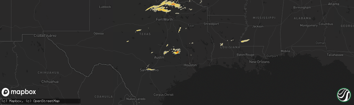
Hail Map on February 3, 2012
The weather event on February 3, 2012 includes Hail map. 5 states and 212 cities were impacted and suffered possible damage. The total estimated number of properties impacted is 19,278.
Want more than just the map?
Turn this storm into a full workflow.
- Owner + property data so you know who to knock
- OnDemand branded weather history reports to win the "did we even have hail?" argument
- RoofTrace estimate so reps stop guessing numbers at the door
Bought this map? Upgrade within 7 days and we'll credit the $230. (10-15 min setup call)
Hail
19,278
Estimated number of impacted properties by a 1.00" hail or larger6,562
Estimated number of impacted properties by a 1.75" hail or larger0
Estimated number of impacted properties by a 2.50" hail or largerStates Impacted by Hail Map on February 3, 2012
Storm reports
Texas
| Date | Description |
|---|---|
| 02/03/20125:02 PM CST | 5 nw alvord |
| 02/03/20125:02 PM CST | Quarter-size hail reported e of st. Jo |
| 02/03/20125:00 PM CST | In sunset |
| 02/03/20124:55 PM CST | Quarter-sized hail 3 w of st. Jo |
| 02/03/20123:15 PM CST | A local report indicates 1.00 inch wind near VASHTI |
| 02/03/20121:45 PM CST | A local report indicates 1.25 inch wind near 7 S WINDTHORST |
| 02/02/201211:15 PM CST | 1 and quarter size hail. |
| 02/02/201211:15 PM CST | A local report indicates 1.00 inch wind near KIRBY |
| 02/02/201210:55 PM CST | A local report indicates 1.00 inch wind near CASTLE HILLS |
| 02/02/201210:45 PM CST | Quarter size hail and 1 inch of rainfall in 30 minutes. |
| 02/02/201210:30 PM CST | Quarter size near babcock and 410. |
| 02/02/20128:40 PM CST | Broke out skylight...hail possibly bigger. In bonham |
| 02/02/20128:36 PM CST | Lake bonham |
| 02/02/20128:19 PM CST | In ravenna at cemetery |
| 02/02/20127:57 PM CST | Quarter hail. Also water over road. |
| 02/02/20127:56 PM CST | Nickels to quarters |
| 02/02/20127:38 PM CST | 2.25 inch hail just north of the a and m campus. |
| 02/02/20127:38 PM CST | Power poles down on ashford road and finfeather road. |
| 02/02/20127:35 PM CST | One inch hail caused a broken window on home at marion pugh and george bush drive. |
| 02/02/20127:25 PM CST | From previous storm. Hail covering the ground. Travel difficult. Hail fog also. |
| 02/02/20127:20 PM CST | Quarter sized hail in college station at marion pugh and george bush drive...other pea sized hail reports at bizzell street and lincoln avenue. |
| 02/02/20127:20 PM CST | Quarters covering ground |
| 02/02/20127:11 PM CST | A local report indicates 1.00 inch wind near 3 W KRUM |
| 02/02/20127:10 PM CST | A local report indicates 1.00 inch wind near DENISON |
| 02/02/20127:09 PM CST | A local report indicates 1.00 inch wind near SOUTHMAYD |
| 02/02/20127:04 PM CST | Chicken egg sized hail 1/2 mile se of north tx regional airport |
| 02/02/20127:04 PM CST | 1 ne kgyi |
| 02/02/20127:01 PM CST | 2ne kgyi |
| 02/02/20126:59 PM CST | Golf balls at kgyi. Kgyi awos reports g37kt. |
| 02/02/20126:50 PM CST | Tornado touched about 2 miles northeast of snook and did major damage to a large metal building. The tornado also moved and flipped an automobile about 50 yards. 5 eigh |
| 02/02/20126:48 PM CST | Possible tornado on the ground in snook...power lines down. Fedex facility severely damaged. |
| 02/02/20126:45 PM CST | Hail covered fm 455 1 mile east of slidell |
| 02/02/20126:45 PM CST | Tornado touched down in snook damaging numerous homes uprooting trees and destroying several barns and metal sheds. Storm was on the ground for about 2miles and a path |
| 02/02/20126:42 PM CST | A local report indicates 1.25 inch wind near 1 W SLIDELL |
| 02/02/20126:40 PM CST | A local report indicates 1.00 inch wind near 5 N POTTSBORO |
| 02/02/20126:39 PM CST | A local report indicates 1.00 inch wind near 4 N POTTSBORO |
| 02/02/20126:34 PM CST | A local report indicates 1.00 inch wind near SLIDELL |
| 02/02/20126:06 PM CST | Golf ball hail reported in alvord... Additional report of ground covered with quarter to ping-pong sized hail |
Mississippi
| Date | Description |
|---|---|
| 02/03/20123:30 PM CST | Slightly larger than quarter size hail fell in meadville |
| 02/03/20122:30 PM CST | Two trees down along kingston road |
Louisiana
| Date | Description |
|---|---|
| 02/03/201212:05 PM CST | Trees down along highway 129 near monterey |
Arkansas
| Date | Description |
|---|---|
| 02/02/201210:31 PM CST | Estimated 60-70 mph winds caused damage in a 2-mile swath across waldron. Dozens of trees and power lines were blown down...as well as street lights. Several houses had |
Oklahoma
| Date | Description |
|---|---|
| 02/03/20125:52 PM CST | Hwy 77 in town |
| 02/03/20125:10 PM CST | A local report indicates 1.75 inch wind near SEMINOLE |
| 02/03/20123:54 PM CST | A local report indicates 1.00 inch wind near WAURIKA |
| 02/03/20123:45 PM CST | Hwy 81 |
| 02/02/20126:25 PM CST | A local report indicates 1.00 inch wind near WILLIS |
Cities Impacted by Hail Map on February 3, 2012
- Cache, OK
- Indiahoma, OK
- Bonham, TX
- Dodd City, TX
- Windom, TX
- Decatur, TX
- Krum, TX
- Burkett, TX
- Windthorst, TX
- Olney, TX
- Aubrey, TX
- Jacksboro, TX
- Henrietta, TX
- Bellevue, TX
- Temple, TX
- Lott, TX
- Burlington, TX
- Rosebud, TX
- Bowie, TX
- Ponder, TX
- Gainesville, TX
- Era, TX
- Chico, TX
- Muenster, TX
- Celina, TX
- Alvord, TX
- Sanger, TX
- Pilot Point, TX
- Forestburg, TX
- Sunset, TX
- Denton, TX
- Rosston, TX
- Saint Jo, TX
- Meadville, MS
- Taylor, TX
- Coupland, TX
- Thrall, TX
- Kerens, TX
- Caldwell, TX
- Bryan, TX
- Valley View, TX
- Waurika, OK
- Temple, OK
- Hastings, OK
- Wewoka, OK
- Macomb, OK
- Maud, OK
- Earlsboro, OK
- Seminole, OK
- Tecumseh, OK
- Farmersville, TX
- Somerville, TX
- College Station, TX
- Thorndale, TX
- Denison, TX
- Talihina, OK
- Wister, OK
- Red Oak, OK
- Pennington, TX
- Kennard, TX
- Groveton, TX
- Sulphur Bluff, TX
- Talco, TX
- Ladonia, TX
- Leonard, TX
- Honey Grove, TX
- Sherman, TX
- San Antonio, TX
- Rogers, TX
- Snow, OK
- Iola, TX
- Eola, TX
- Vancourt, TX
- Inola, OK
- Coweta, OK
- Broken Arrow, OK
- Paden, OK
- Ardmore, OK
- Marietta, OK
- Overbrook, OK
- Madill, OK
- Savoy, TX
- Ector, TX
- Cross Plains, TX
- Saint Hedwig, TX
- Jbsa Ft Sam Houston, TX
- Adkins, TX
- Converse, TX
- Byers, TX
- Comanche, OK
- Pottsboro, TX
- Stringtown, OK
- Rush Springs, OK
- Lindsay, OK
- Pryor, OK
- Ravenna, TX
- Hendrix, OK
- Bells, TX
- Soper, OK
- Boswell, OK
- Taloga, OK
- Fort Towson, OK
- Foster, OK
- Marlow, OK
- Crosby, MS
- Woodville, MS
- Durant, OK
- Burneyville, OK
- Leedey, OK
- Centrahoma, OK
- Coalgate, OK
- Mclean, TX
- Snook, TX
- Marble Falls, TX
- Walters, OK
- Caddo Mills, TX
- Princeton, TX
- Greenville, TX
- Hearne, TX
- Milano, TX
- Gause, TX
- Bradley, OK
- Montague, TX
- Thackerville, OK
- Mead, OK
- Pitkin, LA
- Hineston, LA
- Trenton, TX
- Cartwright, OK
- Tom Bean, TX
- Whitesboro, TX
- Whitewright, TX
- Kingston, OK
- Gordonville, TX
- Nocona, TX
- Telephone, TX
- Sadler, TX
- Leon, OK
- Ivanhoe, TX
- Horseshoe Bay, TX
- Bokchito, OK
- Bennington, OK
- Malakoff, TX
- Mabank, TX
- Trinidad, TX
- Howe, TX
- Konawa, OK
- Leesville, LA
- Cameron, TX
- Broken Bow, OK
- Rattan, OK
- Coleman, TX
- Roxie, MS
- Lane, OK
- Atoka, OK
- De Queen, AR
- Ben Franklin, TX
- Roxton, TX
- Cooper, TX
- Rockdale, TX
- Bulverde, TX
- Calvert, TX
- Argyle, TX
- Natchez, MS
- Gloster, MS
- Caddo, OK
- Bogata, TX
- Haworth, OK
- Winthrop, AR
- Duncan, OK
- La Vernia, TX
- Marion, TX
- Seguin, TX
- Antlers, OK
- Pineville, LA
- Randlett, OK
- Chouteau, OK
- Okemah, OK
- Rising Star, TX
- Wolfe City, TX
- Clarendon, TX
- Helotes, TX
- Streetman, TX
- Nashoba, OK
- Anadarko, OK
- Elgin, TX
- Asher, OK
- Lake Creek, TX
- Calera, OK
- Colbert, OK
- Holdenville, OK
- Lovelady, TX
- Moyers, OK
- Pecan Gap, TX
- Houston, TX
- Larue, TX
- Collinsville, TX
- Hugo, OK
- Grant, OK
- Gracemont, OK
- Deville, LA
- Eagletown, OK
- Okmulgee, OK
- Cleveland, TX
- Conroe, TX
- Willis, TX
- Caney, OK
- Coleman, OK
- Kenefic, OK
- Finley, OK
- Wichita Falls, TX
- Anderson, TX