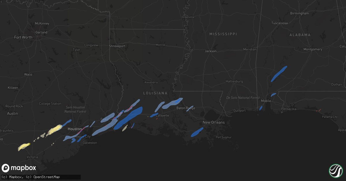
Hail Map in Louisiana on January 24, 2023
Get this storm
January 24 map
$229
one time, instant access
Download today. No call, no setup
Keep the $229
Bought the map and want the full workflow? Apply the entire $229 to a subscription within 7 days. None of it is wasted.
Every map, not just this one
This buys you this map. Subscription and you get every map we run, in the markets you choose from a few cities to whole states to nationwide. Plus real-time alerts the moment a storm fires.
Contact data
Name, contact info, occupancy, even credit band for addresses in the footprint. You go from where it hit to who to call.
Become the source they trust
Unlimited branding weather history reports on demand. You already have the documented answer ready for the property owner, and you are the one who showed up with it.
Property data and RoofTrace estimates
Pull up any address you have got, its value and the exact code rules for that jurisdiction, straight from One Click Code. Then RoofTrace estimates the squares, pitch, and roof value, priced the way you price.
Storm reports in Louisiana
Louisiana
| Date | Description |
|---|---|
| 01/24/20235:23 PM CST | Asos station klch lake charles. |
| 01/24/20235:17 PM CST | A local report indicates a tornado near 4 S RAGLEY |
| 01/24/20235:13 PM CST | Several homes had roofs blow off... Trees down... Power lines down around ragley. |
| 01/24/20235:13 PM CST | Several homes had r |
| 01/24/20235:12 PM CST | Several homes had roof damage and trees blow down from the tornado. |
| 01/24/20235:12 PM CST | A tornado touched down near jackson gimnick loop causing damage to trees... Power poles... And multiple outbuildings. The tornado then moved northeast through a heavily |
| 01/24/20235:12 PM CST | A tornado touched down near jackson gimnick loop causing damage to trees... Power poles... And multiple outbuildings. The tornado then moved northeast through a heavily |
| 01/24/20235:11 PM CST | Report from mping: 1-inch tree limbs broken; shingles blown off. |
| 01/24/20235:10 PM CST | Radar indicated tds. |
| 01/24/20235:05 PM CST | A tornado touched down near perkins pipeline road and moved northeast through northern portions of calcasieu parish. Damage to trees were noted as the tornado crossed p |
| 01/24/20234:49 PM CST | Radar indicates tds. |
| 01/24/20234:46 PM CST | Several trees blow down on la 109. Emergency crews inspecting the region for more damage. |
| 01/24/20234:45 PM CST | An ef1 tornado is either a continuation of the orange county... Texas tornado... Or touched down in the sabine river swamp... And impacted portions of western and centr |
| 01/24/20234:44 PM CST | The gum slough tornado touched down just south of line road... And merged with the nibletts bluff tornado. Trees were damaged while sections of roofs were taken off of |
| 01/24/20234:38 PM CST | Damaged homes and snapped trees on navajo trail and big woods/edgerly roads. |
| 01/23/202310:18 PM CST | Large tree down on brewster rd near hwy 1077. Time estimated from radar. |
| 01/23/202310:12 PM CST | Damage on dantin st. And st. Phillip st. In raceland. Possible tornado. |
| 01/23/202310:01 PM CST | A brief tornado touched down near holley street and moved quickly northeast. A rv that was not tied down was flipped here along with minor fence damage. Farther northea |
| 01/23/202310:00 PM CST | Damage to a homes near the intersection of bayou bend and hwy 316. Possible tornado. |
| 01/23/20239:59 PM CST | Overturned travel trailer near funderburk and broadmoor. Unknown damage also reported in bayou blue. |
| 01/23/20238:52 PM CST | Trained spotter measured 65 mph wind gust using handheld anemometer. |
| 01/23/20238:47 PM CST | Corrects previous tornado report from 3 nnw carville. Em reported a travel trailer rolled and was destroyed on steward st. Time estimated from radar. |
| 01/23/20237:39 PM CST | *** 3 inj *** a brief tornado touched down near cuff point drive and moved northeast before lifting near michael lane. Three manufactured homes were damaged which were |
| 01/23/20237:39 PM CST | *** 3 inj *** corrects previous tornado report from 2 ese new roads. A brief tornado touched down near cutt pointe drive and moved northeast before lifting near michael |
| 01/23/20237:34 PM CST | *** 3 inj *** mobile homes overturned on morel ln and trees down in the area also. Time estimated from radar. Report updated to reflect 3 minor to moderate injuries tra |
| 01/23/20237:34 PM CST | Mobile homes overturned on morel ln and trees down in the area also. Time estimated from radar. |
| 01/23/20236:35 PM CST | Thunderstorm wind gusts to 63 mph. |
| 01/23/20236:27 PM CST | Semi overturned near rayne... La. |
Cities Impacted by Hail Map on January 24, 2023
- Starks, LA
- Dequincy, LA
- Vinton, LA
- Sulphur, LA
- Welsh, LA
- Iowa, LA
- Westlake, LA
- Jennings, LA
- Hackberry, LA
- Elton, LA
- Cameron, LA
- Kinder, LA
- Lake Charles, LA
- Creole, LA
- Ragley, LA
- Dry Creek, LA
- Reeves, LA
- Mittie, LA
- Duson, LA
- Rayne, LA
- Scott, LA
- Crowley, LA
- Morse, LA
- Estherwood, LA
- Port Barre, LA
- Opelousas, LA
- Branch, LA
- Church Point, LA
- Washington, LA
- Arnaudville, LA
- Krotz Springs, LA
- Melville, LA
- Jarreau, LA
- New Roads, LA
- Jackson, LA
- Morganza, LA
- Maringouin, LA
- Saint Francisville, LA
- Lottie, LA
- Livonia, LA
- Oscar, LA
- Fordoche, LA
- Lakeland, LA
- Ventress, LA
- Walker, LA
- Baton Rouge, LA
- Denham Springs, LA
- Gibson, LA
- Des Allemands, LA
- Houma, LA
- Schriever, LA
- Thibodaux, LA
- Raceland, LA
- Mathews, LA
- Theriot, LA
- Gray, LA
- Yoakum, TX
- Yorktown, TX
- Cuero, TX
- Sealy, TX
- Brookshire, TX
- Irvington, AL
- Grand Bay, AL
- Gainestown, AL
- Vredenburgh, AL
- Beatrice, AL
- Jackson, AL
- Frisco City, AL
- Franklin, AL
- Grove Hill, AL
- Whatley, AL
- Bay Minette, AL
- Hallettsville, TX
- Wallis, TX
- Eagle Lake, TX
- Garwood, TX
- Columbus, TX
- Weimar, TX
- Wharton, TX
- El Campo, TX
- Alleyton, TX
- Fulshear, TX
- Katy, TX
- Westhoff, TX
- Houston, TX
- Tomball, TX
- Cypress, TX
- Spring, TX
- Pearland, TX
- Baytown, TX
- Richmond, TX
- Rosharon, TX
- Deer Park, TX
- Needville, TX
- Pasadena, TX
- La Porte, TX
- Guy, TX
- Manvel, TX
- Missouri City, TX
- Bacliff, TX
- Kemah, TX
- League City, TX
- Dickinson, TX
- Santa Fe, TX
- Alvin, TX
- Liberty, TX
- Devers, TX
- Wallisville, TX
- Bridge City, TX
- Port Neches, TX
- Port Arthur, TX
- Anahuac, TX
- Winnie, TX
- Groves, TX
- Nederland, TX
- Beaumont, TX
- Orange, TX
- Vidor, TX
- Buna, TX
- Kaplan, LA
- Maurice, LA
- Santa Rosa Beach, FL
- Vernon, FL


