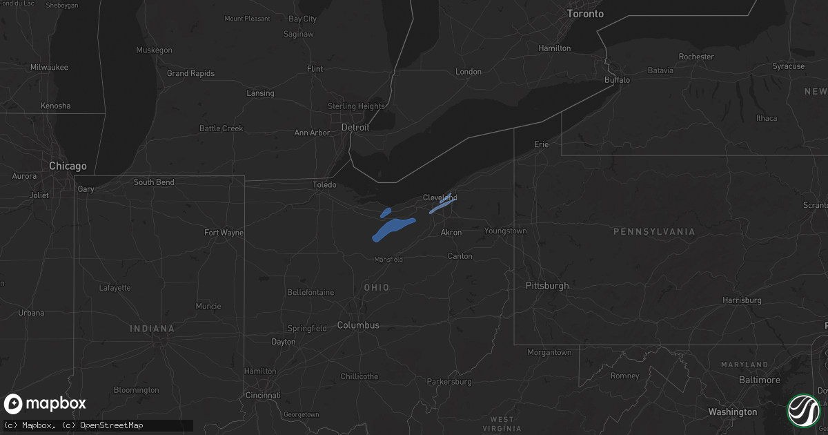
Hail Map in Ohio on January 19, 2023
Get this storm
January 19 map
$229
one time, instant access
Download today. No call, no setup
Keep the $229
Bought the map and want the full workflow? Apply the entire $229 to a subscription within 7 days. None of it is wasted.
Every map, not just this one
This buys you this map. Subscription and you get every map we run, in the markets you choose from a few cities to whole states to nationwide. Plus real-time alerts the moment a storm fires.
Contact data
Name, contact info, occupancy, even credit band for addresses in the footprint. You go from where it hit to who to call.
Become the source they trust
Unlimited branding weather history reports on demand. You already have the documented answer ready for the property owner, and you are the one who showed up with it.
Property data and RoofTrace estimates
Pull up any address you have got, its value and the exact code rules for that jurisdiction, straight from One Click Code. Then RoofTrace estimates the squares, pitch, and roof value, priced the way you price.
Storm reports in Ohio
Ohio
| Date | Description |
|---|---|
| 01/19/20235:58 PM CST | Tree and wires down on rydalmount road. |
| 01/19/20235:58 PM CST | Tree down across ardmore. |
| 01/19/20235:58 PM CST | Tree down and blocking the road at clarendon and lee roads. |
| 01/19/20235:56 PM CST | Very large tree down across edgepark drive. |
| 01/19/20235:48 PM CST | Measured 63 mph gust relayed through skywarn. |
| 01/19/20235:40 PM CST | Light pole down near royalton and howe roads. Report obtained via social media. |
| 01/19/20235:25 PM CST | Tree downed along richmond rd in chatham township. Time estimated via radar. |
| 01/19/20235:10 PM CST | A few trees and large limbs down in and around the city of ashland. Time estimated via radar. |
| 01/19/20235:05 PM CST | Tree and powerlines down. |
| 01/19/20234:58 PM CST | Scattered reports of trees and wires down across huron county. Time estimated via radar. |
| 01/19/20234:52 PM CST | Tree downed in franklin township. Time estimated via radar. |
| 01/19/20234:49 PM CST | Tree downed near springfield township. Time estimated via radar. |
| 01/19/20234:48 PM CST | Tree and powerlines down on spring street. |
| 01/19/20234:32 PM CST | Tree across roadway at sr 19 and e cole road. |
| 01/19/20234:32 PM CST | A few reports of limbs down in sandusky county... Mainly in the vicinity of clyde. Time estimated via radar. |
| 01/19/20234:26 PM CST | Power lines reported down. |
| 01/19/20234:23 PM CST | A few reports of trees and wires down in the vicinity of bucyrus. Time estimated via radar. |
| 01/19/20234:02 PM CST | Tree downed on county highway 97 between county highways 42 and 47. |
| 01/18/20236:44 PM CST | Road closed due to downed tree and/or wires. Time estimated via radar. |
| 01/18/20236:34 PM CST | Tree downed across road. Time estimated via radar. |
| 01/18/20236:29 PM CST | Report and photo of downed tree and power line in backyard. Time estimated based on radar. |
| 01/18/20236:25 PM CST | Multiple roads closed in and around burton due to downed trees and/or wires. Time estimated via radar. |
| 01/18/20236:16 PM CST | Road closed due to downed tree and/or wires in chesterland. Time estimated via radar. |
| 01/18/20236:01 PM CST | Tree down on euclid avenue. |
All States Impacted by Hail Map on January 19, 2023
Cities Impacted by Hail Map on January 19, 2023
- Milan, OH
- Berlin Heights, OH
- Huron, OH
- Norwalk, OH
- Collins, OH
- Maple Heights, OH
- Independence, OH
- North Royalton, OH
- Beachwood, OH
- Strongsville, OH
- Cleveland, OH
- Plymouth, OH
- Wellington, OH
- New London, OH
- Grafton, OH
- North Fairfield, OH
- Lagrange, OH
- Shelby, OH
- Willard, OH
- Greenwich, OH
- Wakeman, OH
- Cheswick, PA
- Pittsburgh, PA
- Springdale, PA
- Harwick, PA
- Tarentum, PA
- Oakmont, PA
- Verona, PA
- New Kensington, PA


