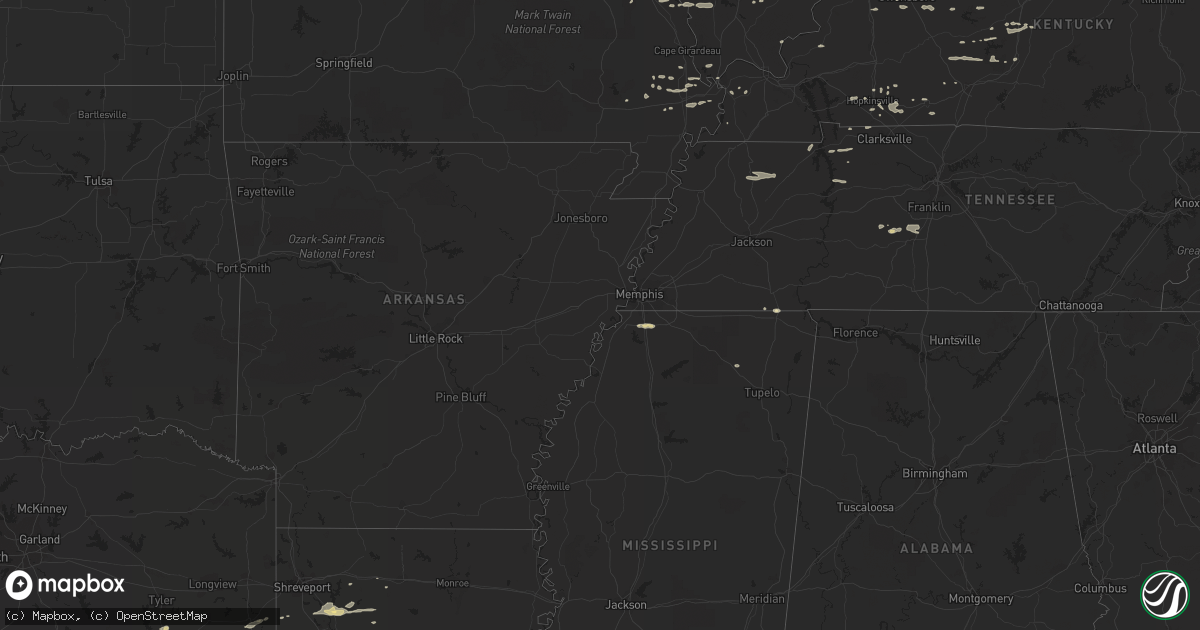
Hail Map in Mississippi on January 17, 2012
Get this storm
January 17 map
$229
one time, instant access
Download today. No call, no setup
Keep the $229
Bought the map and want the full workflow? Apply the entire $229 to a subscription within 7 days. None of it is wasted.
Every map, not just this one
This buys you this map. Subscription and you get every map we run, in the markets you choose from a few cities to whole states to nationwide. Plus real-time alerts the moment a storm fires.
Contact data
Name, contact info, occupancy, even credit band for addresses in the footprint. You go from where it hit to who to call.
Become the source they trust
Unlimited branding weather history reports on demand. You already have the documented answer ready for the property owner, and you are the one who showed up with it.
Property data and RoofTrace estimates
Pull up any address you have got, its value and the exact code rules for that jurisdiction, straight from One Click Code. Then RoofTrace estimates the squares, pitch, and roof value, priced the way you price.
Storm reports in Mississippi
Mississippi
| Date | Description |
|---|---|
| 01/17/20124:07 PM CST | *** 2 inj *** probable tornado...path about 100 yards wide...along mail route rd and clear creek church rd...mobile home destroyed and one house heavily damaged...numer |
| 01/17/20124:02 PM CST | *** 2 inj *** path length 3 miles...max width 1/4 mile...moved to 7 ne sandy hook. One mobile home was destroyed...wood frame home was heavily damaged...power poles wer |
| 01/17/201212:35 PM CST | One inch hail reported by officer on hwy 305 near byhalia. |
| 01/17/201212:00 PM CST | Tornado sighted in the dumas pine grove area near highway 4. |
All States Impacted by Hail Map on January 17, 2012
Cities Impacted by Hail Map on January 17, 2012
- Slaughter, LA
- Clinton, LA
- Carthage, TX
- Laneville, TX
- Greenfield, TN
- Deville, LA
- Hernando, MS
- Lovelady, TX
- Apple Springs, TX
- Groveton, TX
- Pennington, TX
- Crockett, TX
- Mount Enterprise, TX
- Woodville, MS
- Diboll, TX
- Lufkin, TX
- Sonora, KY
- Philpot, KY
- Owensboro, KY
- Royalton, IL
- Fluker, LA
- Roseland, LA
- Amite, LA
- Keatchie, LA
- Henderson, KY
- Russellville, KY
- Westport, KY
- La Grange, KY
- Seymour, IN
- Lewisburg, KY
- Sharon, TN
- McKenzie, TN
- Dresden, TN
- Gleason, TN
- Hymera, IN
- Shelburn, IN
- Williamsport, TN
- Hampshire, TN
- Duck River, TN
- Santa Fe, TN
- New Albany, MS
- Centreville, MS
- Gloster, MS
- Keenes, IL
- Nesbit, MS
- Williams, IN
- Mitchell, IN
- Shoals, IN
- Charleston, MO
- Centerville, TN
- Sims, IL
- Carrier Mills, IL
- Ringgold, LA
- Calhoun, KY
- Robards, KY
- Alexandria, LA
- Chaffee, MO
- Golconda, IL
- Fredericktown, MO
- Boonville, IN
- Marion, KY
- West Union, IL
- Noble, IL
- Clay City, IL
- Mount Erie, IL
- Odon, IN
- Crane, IN
- Loogootee, IN
- Benton, MO
- Hopkinsville, KY
- Wickliffe, KY
- Frohna, MO
- Perryville, MO
- Olney, IL
- Effie, LA
- Bienville, LA
- Shreveport, LA
- Coushatta, LA
- Elm Grove, LA
- Castor, LA
- Pride, LA
- Greenwell Springs, LA
- Greensburg, LA
- Bell City, MO
- Sikeston, MO
- Boyce, LA
- Elmer, LA
- Leesville, LA
- Lena, LA
- Dubberly, LA
- Hornbeck, LA
- Anacoco, LA
- Otis, LA
- Simpson, LA
- Jacksonville, TX
- Carbondale, IL
- Murphysboro, IL
- Pomona, IL
- Long Branch, TX
- Corinth, MS
- Tamms, IL
- Sparta, IL
- Louisville, IL
- Bowling Green, KY
- Norris City, IL
- Troup, TX
- Reklaw, TX
- Henderson, TX
- Rusk, TX
- Bullard, TX
- Blue Mountain, MS
- Ripley, MS
- Carterville, IL
- Herrin, IL
- Clarkson, KY
- Leitchfield, KY
- Barlow, KY
- Cairo, IL
- Crofton, KY
- Arcadia, LA
- Elkton, KY
- Pembroke, KY
- Trenton, KY
- Guthrie, KY
- Deridder, LA
- Waverly, TN
- Caneyville, KY
- Whitesville, KY
- Reynolds Station, KY
- Tylertown, MS
- Odin, IL
- Salem, IL
- Cave City, KY
- West Frankfort, IL
- Thompsonville, IL
- Durham, CA
- Ramer, TN
- Pocahontas, TN
- Morgantown, KY
- Auburn, KY
- Gorham, IL
- Grand Tower, IL
- Jacob, IL
- Saline, LA
- Broughton, IL
- Parkersburg, IL
- Iuka, IL
- Columbia, TN
- Spring Hill, TN
- Simsboro, LA
- Ava, IL
- Campbell Hill, IL
- Steeleville, IL
- Rockwood, IL
- Chester, IL
- Ethel, LA
- Rinard, IL
- Hodgenville, KY
- Buffalo, KY
- Magnolia, KY
- Saint Mary, MO
- Sainte Genevieve, MO
- Belle Rive, IL
- Guys, TN
- Wheeler, IL
- East Prairie, MO
- Macedonia, IL
- Pineville, LA
- Sieper, LA
- Slagle, LA
- Lewisport, KY
- Washington, IN
- Plainville, IN
- Bruceville, IN
- Matthews, MO
- Bertrand, MO
- Rockport, IN
- Nashville, IL
- Adairville, KY
- Cloverport, KY
- Hawesville, KY
- Newton, IL
- Roundhill, KY
- Jetson, KY
- Brownsville, KY
- Cannelton, IN
- Tell City, IN
- Chrisney, IN
- Cunningham, KY
- Lawrenceville, IL
- Oran, MO
- Horse Cave, KY
- Advance, MO
- Bloomfield, MO
- Maceo, KY
- Dale, IN
- Huntingburg, IN
- Elberfeld, IN
- Falls Of Rough, KY
- Fordsville, KY
- Magnolia, MS
- Newburgh, IN
- Cumberland City, TN
- Dover, TN
- Stewart, TN
- Tennessee Ridge, TN
- Marion, IL
- Evansville, IN
- Dexter, MO
- Big Rock, TN
- Opdyke, IL
- Mount Vernon, IL
- Bonnie, IL
- Utica, KY
- Carmi, IL
- Dieterich, IL
- Oakdale, IL
- Coulterville, IL
- Tilden, IL
- Flora, IL
- Xenia, IL
- Marksville, LA
- Moreauville, LA
- Leopold, IN
- Lamar, IN
- Evanston, IN
- Dudley, MO
- Cisne, IL
- Barnhill, IL
- Mammoth Cave, KY
- Essex, MO
- Waltonville, IL
- Scheller, IL
- Upton, KY
- Garfield, KY
- Hudson, KY
- Harned, KY
- Center Point, LA
- Jonesville, LA
- Du Bois, IL
- Ashley, IL
- Hineston, LA
- Baldwin, IL
- Galatia, IL
- Gracey, KY
- Cadiz, KY
- Crossville, IL
- Buchanan, TN
- Clinton, KY
- Jamestown, LA
- White Mills, KY
- Dry Creek, LA


