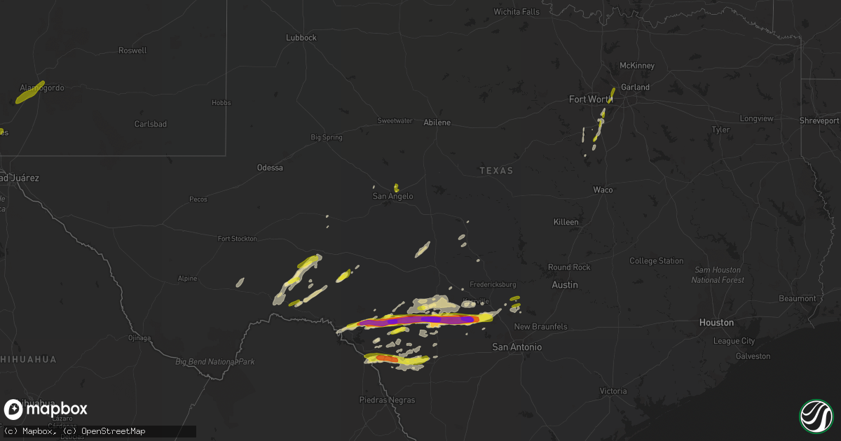
Hail Map in Texas on January 15, 2017
Get this storm
January 15 map
$229
one time, instant access
Download today. No call, no setup
Keep the $229
Bought the map and want the full workflow? Apply the entire $229 to a subscription within 7 days. None of it is wasted.
Every map, not just this one
This buys you this map. Subscription and you get every map we run, in the markets you choose from a few cities to whole states to nationwide. Plus real-time alerts the moment a storm fires.
Contact data
Name, contact info, occupancy, even credit band for addresses in the footprint. You go from where it hit to who to call.
Become the source they trust
Unlimited branding weather history reports on demand. You already have the documented answer ready for the property owner, and you are the one who showed up with it.
Property data and RoofTrace estimates
Pull up any address you have got, its value and the exact code rules for that jurisdiction, straight from One Click Code. Then RoofTrace estimates the squares, pitch, and roof value, priced the way you price.
Storm reports in Texas
Texas
| Date | Description |
|---|---|
| 01/15/20175:56 PM CST | A local report indicates 2.50 inch wind near 9 NNE KICKAPOO CAVERN S |
| 01/15/20175:45 PM CST | Tennis ball size hail 17 miles sw of rocksprings |
| 01/15/20175:36 PM CST | Damage to homes in the coryell city area |
| 01/15/20175:30 PM CST | Quarter to ping pong size hail covering the road on highway 377 near fm2523 |
| 01/15/20175:27 PM CST | Quarter to slightly larger size hailstones observed |
| 01/15/20175:03 PM CST | Nickel to quarter size hail reported by border patrol agents one mile south of the 277 and 377 highway intersection |
| 01/15/20173:48 PM CST | Kbtx reporter forwarded video of tornado passing near highway 21 by north zulch. Emergency manager reported minor tree damage in the area of diserens and bundic rd.... |
| 01/15/20172:47 PM CST | A local report indicates 59 MPH wind near PERSIMMON GAP |
| 01/15/20172:48 AM CST | Damage occurred to the mexia state supported living center near hwy 171 and fm 2838. Six bldgs were damaged... Roof panels were torn off... And portable bldgs shifted o |
| 01/14/201711:20 PM CST | Delayed report - several homes with roof damage...multiple trees blown down and a flagpole snapped. |
| 01/14/201710:10 PM CST | Thunderstorm wind gusts estimated to 60 mph |
| 01/14/201710:00 PM CST | A local report indicates 64 MPH wind near MURPHY |
| 01/14/20179:50 PM CST | A local report indicates 1.00 inch wind near KENDALIA |
| 01/14/20179:40 PM CST | 4-6 inch tree limbs and 6 to 8 feet tall fences downed near eldorado parkway and fm423 |
| 01/14/20179:40 PM CST | About 10-20 windows were blown out of a 17-story office building near i-35 and 635 |
| 01/14/20179:39 PM CST | Estimated 65 mph wind gust. Dallas north tollway and belt line road. |
| 01/14/20179:30 PM CST | A local report indicates 65 MPH wind near 3 NNE PLANO |
| 01/14/20179:26 PM CST | Social media report with photos of large tree limbs down near the intersection of schmidt lane and ernst road. Wind speeds were estimated at 60 mph. |
| 01/14/20178:55 PM CST | At kgpm |
| 01/14/20178:43 PM CST | Confirmed tornado state highway 161 and arkansas |
| 01/14/20178:30 PM CST | From a photo it appears a portion of the mini mart number13 business awning near the intersection of highway 173 and veterans highway in kerrville was torn down by high |
| 01/14/20178:30 PM CST | Shingles off roof near 360 and north holland road |
| 01/14/20178:15 PM CST | A local report indicates 1.25 inch wind near 4 NNW BANDERA |
| 01/14/20178:08 PM CST | A local report indicates 1.75 inch wind near MEDINA |
| 01/14/20178:07 PM CST | A local report indicates 1.00 inch wind near MANSFIELD |
| 01/14/20178:06 PM CST | 607 and 917 4 nne of alvarado |
| 01/14/20178:04 PM CST | Large hail busted out a sky light |
| 01/14/20178:03 PM CST | Large hail producing car dents |
| 01/14/20178:00 PM CST | Photo shows a four inch diameter hailstone as measured with a tailors tape measure |
| 01/14/20178:00 PM CST | Damage to 5-6 warehouse buildings...mostly metal garage doors blown in/out. Time is estimated. |
| 01/14/20177:58 PM CST | Photo shows baseball size hail next to a real baseball |
| 01/14/20177:52 PM CST | Nickel to quarter size hail observed |
| 01/14/20177:46 PM CST | A local report indicates 70 MPH wind near ALVARADO |
| 01/14/20177:45 PM CST | Quarter size hail east of brackettville mainly on the south side of highway 90 |
| 01/14/20177:30 PM CST | 6-8 inch tree limbs down. Roof off of a barn in the sand flat area |
| 01/14/20177:25 PM CST | A local report indicates 1.00 inch wind near 4 SW BRACKETTVILLE |
| 01/14/20177:25 PM CST | Powerlines downed in covington |
| 01/14/20177:25 PM CST | Estimated 70-75 mph winds on fm916 between grandview and rio vista |
| 01/14/20177:20 PM CST | A local report indicates 1.75 inch wind near VANDERPOOL |
| 01/14/20177:19 PM CST | Estimated 60-70 mph winds on fm916 between grandview and rio vista |
| 01/14/20177:08 PM CST | Hail up to the size of quarters near the intersection of us route 83 and texas highway 41. |
| 01/14/20177:00 PM CST | Tornado strat time 7 pm/end time 705 pm. A national weather service damage survey team determined an ef-2 tornado touch down 8 miles southeast of brady. The maximum win |
| 01/14/20177:00 PM CST | Over 100 big oak trees were blown down. There were 30-40 large oak trees broken off at the base. Also... Top half of 100-200 oak trees were stripped. A windmill and pow |
| 01/14/20176:58 PM CST | A local report indicates 3.00 inch wind near 6 N LEAKEY |
| 01/14/20176:58 PM CST | A local report indicates 3.00 inch wind near MEDINA |
| 01/14/20176:58 PM CST | A local report indicates 3.00 inch wind near LEAKEY |
| 01/14/20176:57 PM CST | Trees and powerlines downed and houses damaged in the 1713 area. |
| 01/14/20176:55 PM CST | A local report indicates 2.00 inch wind near 5 N LEAKEY |
| 01/14/20176:49 PM CST | Damage to power lines and transformers near lake whitney. Possible tornado. |
| 01/14/20176:47 PM CST | 4-5 houses damaged including one that loss its roof in the 1713/933 area |
| 01/14/20176:46 PM CST | A local report indicates 1.50 inch wind near 7 NE CAMP WOOD |
| 01/14/20176:34 PM CST | Confirmed tornado south of laguna park. |
| 01/14/20176:25 PM CST | Public report of a large amount of hail. Most the size of peas to marbles...but largest hail stones were quarter size. |
| 01/14/20176:20 PM CST | Delayed report - nws meteorologist reports several roofs/mobile homes damaged in clifton at the intersection of hwy 6 and pecan street. |
| 01/14/20176:16 PM CST | Several trees down in the city of clifton on sh219 and sh6. |
| 01/14/20176:00 PM CST | Report of damage to turkey farms 7 miles southwest of clifton. Time estimated via radar. |
All States Impacted by Hail Map on January 15, 2017
Cities Impacted by Hail Map on January 15, 2017
- Rocksprings, TX
- Bandera, TX
- Medina, TX
- Utopia, TX
- Barksdale, TX
- Leakey, TX
- Camp Wood, TX
- Vanderpool, TX
- Brackettville, TX
- Junction, TX
- Menard, TX
- Dryden, TX
- Del Rio, TX
- Uvalde, TX
- Morgan, TX
- Whitney, TX
- Cleburne, TX
- San Angelo, TX
- Arlington, TX
- Mansfield, TX
- Comstock, TX
- Ozona, TX
- Hillsboro, TX
- Blum, TX
- Covington, TX
- Mason, TX
- Pipe Creek, TX
- Hunt, TX
- Mountain Home, TX
- Boerne, TX
- Center Point, TX
- Comfort, TX
- Rio Frio, TX
- Kerrville, TX
- Kendalia, TX
- Grand Prairie, TX
- Irving, TX
- Brady, TX
- Ingram, TX
- Blanco, TX
- D Hanis, TX
- Big Lake, TX
- Carlsbad, TX
- Rio Vista, TX
- Spring Branch, TX
- Concan, TX
- Grandview, TX
- Venus, TX
- Alvarado, TX
- Fort Stockton, TX
- Marathon, TX
- Mesilla Park, NM
- Las Cruces, NM
- La Mesa, NM
- Mesilla, NM
- White Sands Missile Range, NM
- Alamogordo, NM
- La Luz, NM
- Holloman Air Force Base, NM


