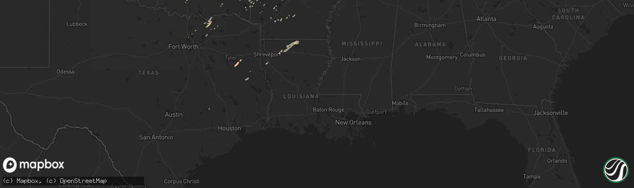
Hail Map in Louisiana on January 12, 2013
The weather event in Louisiana on January 12, 2013 includes Hail map. 5 states and 90 cities were impacted and suffered possible damage. The total estimated number of properties impacted is 0.
Want more than just the map?
Turn this storm into a full workflow.
- Owner + property data so you know who to knock
- OnDemand branded weather history reports to win the "did we even have hail?" argument
- RoofTrace estimate so reps stop guessing numbers at the door
Bought this map? Upgrade within 7 days and we'll credit the $230. (10-15 min setup call)
Hail
0
Estimated number of impacted properties by a 1.00" hail or larger0
Estimated number of impacted properties by a 1.75" hail or larger0
Estimated number of impacted properties by a 2.50" hail or largerStorm reports in Louisiana
Louisiana
| Date | Description |
|---|---|
| 01/12/201311:35 AM CST | Tree down along hwy 1 near yearwood road |
| 01/12/201312:40 AM CST | Tree down on hwy 2 near pattontown road |
| 01/11/201311:40 PM CST | Several vehicles overturned and a couple of travel trailers severely damaged with debris scattered out a half mile to a mile. 2 injuries reported |
| 01/11/201311:30 PM CST | *** 2 inj *** a ef-1 tornado occurred 7 mi se of frierson la snapping hardwood trees. The tornado then tracked northeast into red river parish...15 mi wnw of hall summi |
| 01/11/201310:30 PM CST | Several trees snapped and uprooted. |
Cities Impacted by Hail Map on January 12, 2013
- Overton, TX
- Henderson, TX
- Whitesboro, OK
- Honobia, OK
- Bluff City, AR
- Rosston, AR
- Broken Bow, OK
- Eagletown, OK
- Savoy, TX
- Bells, TX
- Whitewright, TX
- Benton, AR
- Dustin, OK
- Lamar, OK
- Hope, AR
- Umpire, AR
- Waldron, AR
- Bonham, TX
- Randolph, TX
- Dodd City, TX
- Trenton, TX
- Little Elm, TX
- Farmersville, TX
- Troup, TX
- Antlers, OK
- Gillham, AR
- Arcadia, LA
- Allen, OK
- Tupelo, OK
- Story, AR
- Mena, AR
- College Station, TX
- Navasota, TX
- Sibley, LA
- Dubberly, LA
- Sparkman, AR
- Ector, TX
- Nashoba, OK
- Mckinney, TX
- Wickes, AR
- Calvin, OK
- Okolona, AR
- Lewisville, TX
- Flower Mound, TX
- Wolfe City, TX
- Eufaula, OK
- Price, TX
- Dubach, LA
- Nashville, AR
- Homer, LA
- Gibsland, LA
- Farmerville, LA
- Marion, LA
- Spearsville, LA
- Bernice, LA
- Athens, LA
- Prescott, AR
- Mount Ida, AR
- Grand Cane, LA
- Henryetta, OK
- Mcalester, OK
- Chidester, AR
- Springer, OK
- Herndon, KY
- Smithville, OK
- Sims, AR
- Fordyce, AR
- Bearden, AR
- Hot Springs National Park, AR
- Amity, AR
- Telephone, TX
- Ivanhoe, TX
- Ravenna, TX
- Grannis, AR
- Ladonia, TX
- Roxton, TX
- Celina, TX
- Heavener, OK
- Nacogdoches, TX
- Emmet, AR
- Cove, AR
- Watson, OK
- Davis, OK
- Vandervoort, AR
- Wewoka, OK
- Hatfield, AR
- Garrison, TX
- Konawa, OK
- Newhope, AR
- Hodgen, OK


