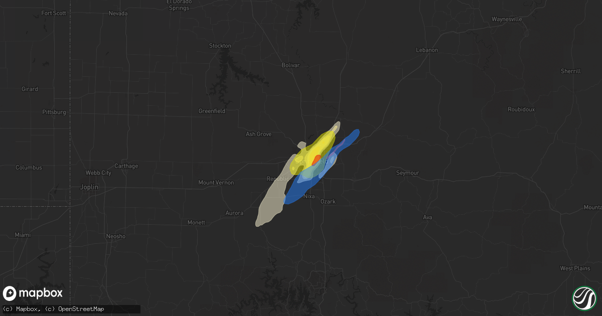
Hail Map in Springfield, MO on January 10, 2020
Get this storm
January 10 map
$229
one time, instant access
Download today. No call, no setup
Keep the $229
Bought the map and want the full workflow? Apply the entire $229 to a subscription within 7 days. None of it is wasted.
Every map, not just this one
This buys you this map. Subscription and you get every map we run, in the markets you choose from a few cities to whole states to nationwide. Plus real-time alerts the moment a storm fires.
Contact data
Name, contact info, occupancy, even credit band for addresses in the footprint. You go from where it hit to who to call.
Become the source they trust
Unlimited branding weather history reports on demand. You already have the documented answer ready for the property owner, and you are the one who showed up with it.
Property data and RoofTrace estimates
Pull up any address you have got, its value and the exact code rules for that jurisdiction, straight from One Click Code. Then RoofTrace estimates the squares, pitch, and roof value, priced the way you price.
Storm reports in Springfield, MO
Springfield, MO
| Date | Description |
|---|---|
| 01/10/20205:57 PM CST | Report from mping: quarter |
| 01/10/20205:43 PM CST | Quarter hail on glenstone avenue near i-44 in springfield. |
| 01/10/20205:42 PM CST | The tornado produced ef1 damage with maximum winds up to 98 mph and a mix width of 75 yards. The tornado was on the ground for 11 minutes along a 7 mile path. The torna |
| 01/10/20205:42 PM CST | Report of half dollar sized hail. |
| 01/10/20205:41 PM CST | Large barn destroyed. An area of damage to trees and some structures extends to the northeast from this area. Fr132 and fr193. Time based on radar. |
| 01/10/20205:40 PM CST | Delayed report and picture of golf ball sized hail on east side of springfield. |
| 01/10/20205:34 PM CST | Report of quarter size hail near golden ave and scenic ave. |
| 01/10/20205:30 PM CST | Report from mping: quarter |
| 01/10/20205:29 PM CST | Public report of quarter size hail. |
All States Impacted by Hail Map on January 10, 2020
All Cities Impacted by Hail Map on January 10, 2020
- Hamilton, TX
- Jonesboro, TX
- Meridian, TX
- Cranfills Gap, TX
- Hico, TX
- Liberty Hill, TX
- Leander, TX
- Aquilla, TX
- Waco, TX
- Abbott, TX
- Hillsboro, TX
- West, TX
- D Hanis, TX
- Dripping Springs, TX
- Boerne, TX
- Kendalia, TX
- Blanco, TX
- Converse, TX
- San Antonio, TX
- Joshua, TX
- Godley, TX
- Quitman, TX
- Alba, TX
- Lipan, TX
- Decatur, TX
- Krum, TX
- Crystal City, TX
- Schertz, TX
- Cibolo, TX
- Uvalde, TX
- Bandera, TX
- Hondo, TX
- Florence, KS
- Burns, KS
- San Saba, TX
- Lometa, TX
- Bend, TX
- Fort Hood, TX
- Gatesville, TX
- Jonesboro, LA
- Evant, TX
- Welling, OK
- Proctor, OK
- Tahlequah, OK
- Park Hill, OK
- Fort Gibson, OK
- Llano, TX
- Hammon, OK
- Cheyenne, OK
- Leedey, OK
- Harper, TX
- Fredericksburg, TX
- Bentonville, AR
- Canton, TX
- Vici, OK
- Comfort, TX
- Center Point, TX
- Sulphur Springs, TX
- Springfield, MO
- Kempner, TX
- Lampasas, TX
- Copperas Cove, TX
- Castell, TX
- La Pryor, TX
- Batesville, TX
- Helena, OK
- Cherokee, OK
- Carmen, OK
- Gainesville, TX
- Ponder, TX
- Brookline, MO
- Hartville, MO
- Fort Worth, TX
- Hinton, OK
- Round Mountain, TX
- Willow City, TX
- Wimberley, TX
- Valley Mills, TX
- Clifton, TX
- Sabinal, TX
- Eufaula, OK
- Checotah, OK
- Iredell, TX
- Walnut Springs, TX
- Morgan, TX
- Shelbyville, TX
- Center, TX
- Broaddus, TX
- Weatherford, TX
- Longview, TX
- Jasper, TX
- Devine, TX
- Pearsall, TX
- Yancey, TX
- Okeene, OK
- Granbury, TX
- Cleburne, TX
- Waukomis, OK
- Bison, OK
- Bronson, TX
- Dundee, MS
- Coahoma, MS
- Cherokee, TX
- Goldthwaite, TX
- Valley Spring, TX
- Burleson, TX
- Crowley, TX
- Gentry, AR
- Decatur, AR
- Siloam Springs, AR
- Muskogee, OK
- Braggs, OK
- Westville, OK
- Stilwell, OK
- Bunch, OK
- Fairview, OK
- Taloga, OK
- Oakwood, OK
- Seiling, OK
- Crowder, OK
- Canadian, OK
- Indianola, OK
- Mcalester, OK
- Sallisaw, OK
- Temple, TX
- Buchanan Dam, TX
- Millsap, TX
- Cookson, OK
- Blossom, TX
- Rio Medina, TX
- Valley View, TX
- Watts, OK
- Summers, AR
- Muenster, TX
- Marietta, OK
- Cleveland, MS
- Burnet, TX
- Fair Grove, MO
- Emory, TX
- Kingfisher, OK
- Azle, TX
- Camargo, OK
- Helotes, TX
- Hennessey, OK
- Grand Saline, TX
- Adkins, TX
- Nacogdoches, TX
- Doss, TX
- Bluffton, TX
- Tow, TX
- Kerrville, TX
- Rosston, TX
- Saint Hedwig, TX
- Jbsa Ft Sam Houston, TX
- Jbsa Lackland, TX
- Marion, TX
- Seguin, TX
- Elkland, MO
- Viola, KS
- Star, TX
- The Colony, TX
- Frisco, TX
- Liberal, MO
- Asbury, MO
- Mindenmines, MO
- Marionville, MO
- Billings, MO
- Clever, MO
- Allen, TX
- Mckinney, TX
- Helena, AR
- Osawatomie, KS
- Paola, KS
- Thackerville, OK
- Chester, OK
- Quitman, LA
- Chatham, LA
- Ruston, LA
- Isola, MS
- Lexington, TX
- Tillar, AR
- Watson, AR
- Porum, OK
- Stigler, OK
- Lake Cormorant, MS
- Hughes, AR
- Robinsonville, MS
- Oxford, MS
- McGregor, TX
- Oglesby, TX
- Crawford, TX
- McQueeney, TX
- Gravette, AR
- Pipe Creek, TX
- Mico, TX
- Medina, TX
- Stonewall, TX
- Sanger, TX
- Paradise, TX
- Rhome, TX
- Boyd, TX
- Springtown, TX
- Zavalla, TX
- Tutwiler, MS
- Drew, MS
- Fontana, KS
- Mason, TX
- Strafford, MO
- Prairie Grove, AR
- Lincoln, AR
- Binger, OK
- Gracemont, OK
- Bremond, TX
- Kosse, TX
- Arlington, TX
- Atoka, OK
- Hulbert, OK
- Eustace, TX
- San Augustine, TX
- Huntington, TX
- Marble Falls, TX
- Stonewall, LA
- Shreveport, LA
- Keithville, LA
- Cleo Springs, OK
- Aline, OK
- Mabank, TX
- Malakoff, TX
- Crane, MO
- Republic, MO
- Aurora, MO
- Okarche, OK
- Chireno, TX
- La Coste, TX
- Lytle, TX
- Castroville, TX
- Natalia, TX
- Moore, TX
- Atascosa, TX
- Anacoco, LA
- Clarksdale, MS
- Lebanon, MO
- Buda, TX
- Granger, TX
- Canehill, AR
- Morrow, AR
- Goltry, OK
- Whitesboro, TX
- Poolville, TX
- Nixa, MO
- Hiwasse, AR
- Jet, OK
- Lynchburg, MO
- Osage Beach, MO
- Lamar, MO
- Vian, OK
- Gore, OK
- Mansfield, TX
- New Braunfels, TX
- Mutual, OK
- Franklin, TX
- Driftwood, TX
- Chester, TX
- Prague, OK
- Tampa, KS
- Ingram, TX
- Anthony, KS
- Whitney, TX
- Johnson City, TX
- Ringwood, OK
- Shawnee, OK
- Tecumseh, OK
- Leon, KS
- Atlanta, KS
- Hernando, MS
- Winnsboro, TX
- Douglass, KS
- Friars Point, MS
- Bluff Dale, TX
- Tolar, TX
- Hitchcock, OK
- Pottsville, TX
- Georgetown, TX
- Mineola, TX
- Choudrant, LA
- Bertram, TX
- Madill, OK
- Haughton, LA
- Princeton, LA
- Bella Vista, AR
- Sulphur Springs, AR
- Nesbit, MS
- Stephenville, TX
- Milam, TX
- Rogersville, MO
- Bradley, AR
- Plain Dealing, LA
- Cumby, TX
- Klondike, TX
- Cedar Park, TX
- Austin, TX
- Inverness, MS
- Enid, OK
- Colcord, OK
- Sheldon, MO
- Milo, MO
- El Dorado Springs, MO
- Oronogo, MO
- Polk, MO
- Fair Play, MO
- Humansville, MO
- Pittsburg, MO
- Wheatland, MO
- Dunnegan, MO
- Dadeville, MO
- Cross Timbers, MO
- Preston, MO
- Flemington, MO
- Hermitage, MO
- Bolivar, MO
- Aldrich, MO
- Noel, MO
- Stella, MO
- Pineville, MO
- Lanagan, MO
- Anderson, MO
- Goodman, MO
- Wentworth, MO
- Cassville, MO
- Galena, MO
- Marshfield, MO
- Branson, MO
- Walnut Shade, MO
- Taneyville, MO
- Ava, MO
- Garrison, MO
- Rockaway Beach, MO
- Chadwick, MO
- Oldfield, MO
- Forsyth, MO
- Phillipsburg, MO
- Niangua, MO
- Conway, MO
- Hermann, MO
- Marthasville, MO
- Owensville, MO
- Bland, MO
- Warrenton, MO
- Linn, MO
- Morrison, MO
- Chamois, MO
- Mount Sterling, MO
- Berger, MO
- Jonesburg, MO
- Grovespring, MO
- Seymour, MO
- Falcon, MO
- Richland, MO
- Stoutland, MO
- Wright City, MO
- Plato, MO
- Mountain Grove, MO
- Foley, MO
- Hamburg, IL
- Batchtown, IL
- Elsberry, MO
- Fieldon, IL
- Hardin, IL
- Winfield, MO
- Cobden, IL
- Stonefort, IL
- Pittsburg, IL
- Carrier Mills, IL
- Carbondale, IL
- Creal Springs, IL
- Pomona, IL
- Makanda, IL
- Carterville, IL
- Harrisburg, IL
- Raleigh, IL
- Murphysboro, IL
- Marion, IL
- Alto Pass, IL
- Thompsonville, IL
- Galatia, IL
- Eldorado, IL
- Metropolis, IL
- Karnak, IL
- Grand Chain, IL
- Grantsburg, IL
- Vienna, IL
- Belknap, IL
- Anna, IL
- Wolf Lake, IL
- Cape Girardeau, MO
- Jackson, MO
- Jonesboro, IL
- Goreville, IL
- Dubberly, LA
- Doyline, LA
- Elm Grove, LA
- Gibsland, LA
- Minden, LA
- Athens, LA
- Arcadia, LA
- Bossier City, LA
- Sibley, LA
- Barksdale Afb, LA
- Spearsville, LA
- Marion, LA
- Bernice, LA
- Farmerville, LA
- Lillie, LA
- Deridder, LA
- Merryville, LA
- Singer, LA
- Benton, LA
- Mound Bayou, MS
- Geary, OK
- Tulsa, OK
- Centerton, AR
- Calvin, OK
- Wetumka, OK
- Atwood, OK
- Holdenville, OK
- Allen, OK
- Locust Grove, OK
- Peggs, OK
- Wagoner, OK
- Salina, OK
- Kansas, OK
- Twin Oaks, OK
- Oaks, OK
- Rose, OK
- Warner, OK
- Pittsburg, OK
- Wardville, OK
- Kiowa, OK
- Rosalia, KS
- Enid, MS
- Byhalia, MS
- Waterford, MS
- Sardis, MS
- Vance, MS
- Sledge, MS
- Blue Mountain, MS
- Courtland, MS
- Ripley, MS
- Merigold, MS
- Myrtle, MS
- Shelby, MS
- Batesville, MS
- Beulah, MS
- Gunnison, MS
- Benoit, MS
- Como, MS
- Lambert, MS
- Lyon, MS
- Ashland, MS
- Hickory Flat, MS
- Coldwater, MS
- Rosedale, MS
- Marks, MS
- Holly Springs, MS
- Senatobia, MS
- Potts Camp, MS
- Parchman, MS
- Rohwer, AR
- Duncan, MS
- Sumner, MS
- Charleston, MS
- Crenshaw, MS
- Boyle, MS
- Winona, MS
- Lake Village, AR
- Greenville, MS
- Sunflower, MS
- Big Creek, MS
- Ruleville, MS
- Greenwood, MS
- McCarley, MS
- Doddsville, MS
- Coila, MS
- Leland, MS
- Eupora, MS
- Duck Hill, MS
- Bruce, MS
- North Carrollton, MS
- Philipp, MS
- Stewart, MS
- Sidon, MS
- Shaw, MS
- Indianola, MS
- Minter City, MS
- Calhoun City, MS
- Moorhead, MS
- Glendora, MS
- Itta Bena, MS
- Dermott, AR
- Schlater, MS
- Coffeeville, MS
- Holcomb, MS
- Grenada, MS
- Gore Springs, MS
- Carrollton, MS
- Tunica, MS
- Eads, TN
- Memphis, TN
- Germantown, TN
- Marianna, AR
- Southaven, MS
- Moscow, TN
- Williston, TN
- Olive Branch, MS
- Sarah, MS
- Red Banks, MS
- Horn Lake, MS
- Collierville, TN
- Walls, MS
- Oakland, TN
- Brickeys, AR
- Rossville, TN
- Newellton, LA
- Satartia, MS
- Vicksburg, MS
- Flora, MS
- Hermanville, MS
- Redwood, MS
- Tallulah, LA
- Jackson, MS
- Port Gibson, MS
- Lorman, MS
- Edwards, MS
- Bentonia, MS
- Bolton, MS
- Raymond, MS
- Utica, MS
- Glen, MS
- Ecru, MS
- Burnsville, MS
- Thaxton, MS
- Saltillo, MS
- Belden, MS
- Waterloo, AL
- Iuka, MS
- Dumas, MS
- Blue Springs, MS
- Baldwyn, MS
- Cherokee, AL
- New Site, MS
- Marietta, MS
- Guntown, MS
- New Albany, MS
- Pontotoc, MS
- Tishomingo, MS
- Booneville, MS
- Rienzi, MS
- Tupelo, MS
- Corinth, MS
- Somerville, TN
- Crossett, AR
- Portland, AR
- Parkdale, AR
- Montrose, AR
- Hamburg, AR
- Monticello, AR
- Wilmar, AR
- Era, TX
- Kopperl, TX
- Glen Rose, TX
- Nemo, TX
- Chatfield, TX
- Corsicana, TX
- Kemp, TX
- Ennis, TX
- Scurry, TX
- Rice, TX
- Barry, TX
- Rainbow, TX
- Kennedale, TX
- Cooper, TX
- Enloe, TX
- Campbell, TX
- Coppell, TX
- Irving, TX
- Carrollton, TX
- Plano, TX
- Lewisville, TX
- Grapevine, TX
- Dallas, TX
- Flower Mound, TX
- Garland, TX
- Richardson, TX
- Somerset, TX
- La Vernia, TX
- Elmendorf, TX
- Von Ormy, TX
- Kingsbury, TX
- Maxwell, TX
- Rosanky, TX
- Bastrop, TX
- Nixon, TX
- San Marcos, TX
- Gonzales, TX
- Luling, TX
- Harwood, TX
- Red Rock, TX
- Dale, TX
- Waelder, TX
- Muldoon, TX
- Moulton, TX
- Kyle, TX
- Flatonia, TX
- La Grange, TX
- Smithville, TX
- Shiner, TX
- Lockhart, TX
- West Point, TX
- Leesville, TX
- Cost, TX
- Fischer, TX
- Canyon Lake, TX
- Iola, TX
- Snook, TX
- Bedias, TX
- Somerville, TX
- Anderson, TX
- College Station, TX
- Caldwell, TX
- Lincoln, TX
- Dime Box, TX
- Giddings, TX
- Burton, TX
- Ledbetter, TX
- Brenham, TX
- Carmine, TX
- Magnolia, TX
- Hempstead, TX
- Hockley, TX
- Montgomery, TX
- Plantersville, TX
- Waller, TX
- Richmond, TX
- Sugar Land, TX
- Stafford, TX
- Rosenberg, TX
- Missouri City, TX
- Tomball, TX
- Spring, TX
- Kilgore, TX
- Hallsville, TX
- Marshall, TX
- Waskom, TX
- Tatum, TX
- Beckville, TX
- De Berry, TX
- Houston, TX
- Karnack, TX
- Mooringsport, LA
- Oil City, LA
- Vivian, LA
- Jefferson, TX
- Belcher, LA
- Buna, TX
- Vidor, TX
- Sour Lake, TX
- Lumberton, TX
- Silsbee, TX
- Call, TX
- Kountze, TX
- Kirbyville, TX
- Beaumont, TX
- Orange, TX
- Port Arthur, TX
- Nederland, TX
- Port Neches, TX
- Bon Wier, TX
- Evans, LA
- Leesville, LA
- Burkeville, TX
- Wiergate, TX
- Newton, TX
- Rusk, TX
- Mount Enterprise, TX
- Cushing, TX
- Bryan, TX
- Rosharon, TX
- Fresno, TX
- Manvel, TX
- Pearland, TX
- Elkins, AR
- Huntsville, AR
- Farmington, AR
- Fayetteville, AR
- Hindsville, AR
- Wesley, AR
- Boles, AR
- Grannis, AR
- Wickes, AR
- Cove, AR
- Vandervoort, AR
- Harvey, AR
- Parks, AR
- Mena, AR
- Havana, AR
- Waldron, AR
- Booneville, AR
- Paris, AR
- Clarksville, AR
- Fort Smith, AR
- Coal Hill, AR
- Branch, AR
- Greenwood, AR
- Lavaca, AR
- Magazine, AR
- Ratcliff, AR
- Altus, AR
- Hartman, AR
- Charleston, AR
- Ozark, AR
- Cecil, AR
- Scranton, AR
- Vendor, AR
- Saint Joe, AR
- Deer, AR
- Hagarville, AR
- Hasty, AR
- Jasper, AR
- Pindall, AR
- Western Grove, AR
- Everton, AR
- Mount Judea, AR
- Yellville, AR
- Jerusalem, AR
- Delaware, AR
- Dennard, AR
- Witts Springs, AR
- Lamar, AR
- London, AR
- Knoxville, AR
- Pelsor, AR
- Dover, AR
- Marshall, AR
- New Blaine, AR
- Tilly, AR
- Leslie, AR
- Russellville, AR
- Hector, AR
- Mount Ida, AR
- Pencil Bluff, AR
- Oden, AR
- Rover, AR
- Ola, AR
- Plainview, AR
- Bluffton, AR
- Briggsville, AR
- Danville, AR
- Delight, AR
- Okolona, AR
- Amity, AR
- Antoine, AR
- Little Rock, AR
- Benton, AR
- Roland, AR
- Mayflower, AR
- Conway, AR
- Maumelle, AR
- North Little Rock, AR
- Jefferson, AR
- Tucker, AR
- Sherrill, AR
- England, AR
- Redfield, AR
- White Hall, AR
- Sheridan, AR
- Carlisle, AR
- Scott, AR
- Stuttgart, AR
- Ulm, AR
- Keo, AR
- Humnoke, AR
- Hazen, AR
- Colt, AR
- Goodwin, AR
- Palestine, AR
- Brinkley, AR
- McCrory, AR
- Parkin, AR
- Cotton Plant, AR
- Hunter, AR
- Wynne, AR
- Wheatley, AR
- McGehee, AR
- Winchester, AR
- Snow Lake, AR
- Mellwood, AR
- Alligator, MS
- Crumrod, AR
- Subiaco, AR


