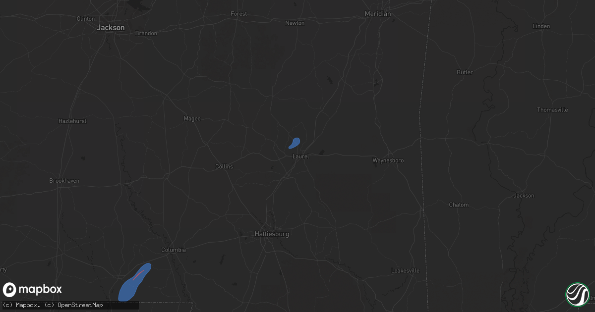
Hail Map in Laurel, MS on January 9, 2026
Get this storm
January 9 map
$229
one time, instant access
Download today. No call, no setup
Keep the $229
Bought the map and want the full workflow? Apply the entire $229 to a subscription within 7 days. None of it is wasted.
Every map, not just this one
This buys you this map. Subscription and you get every map we run, in the markets you choose from a few cities to whole states to nationwide. Plus real-time alerts the moment a storm fires.
Contact data
Name, contact info, occupancy, even credit band for addresses in the footprint. You go from where it hit to who to call.
Become the source they trust
Unlimited branding weather history reports on demand. You already have the documented answer ready for the property owner, and you are the one who showed up with it.
Property data and RoofTrace estimates
Pull up any address you have got, its value and the exact code rules for that jurisdiction, straight from One Click Code. Then RoofTrace estimates the squares, pitch, and roof value, priced the way you price.
Storm reports in Laurel, MS
Laurel, MS
| Date | Description |
|---|---|
| 01/09/20268:49 AM CST | Jones county eoc reported roof damage at a business on hwy 15 n in north laurel. |
| 01/09/20268:49 AM CST | A sign was blown out at a business just off of highway 15 n. |
| 01/09/20268:49 AM CST | Corrects previous tstm wnd dmg report from 1 sse shady grove. Video provided by jones county eoc shows that this damage was produced by a tornado. Roof damage occurred |
All States Impacted by Hail Map on January 9, 2026
All Cities Impacted by Hail Map on January 9, 2026
- Tylertown, MS
- Foxworth, MS
- Camden, MS
- Carthage, MS
- Laurel, MS
- San Saba, TX
- Lometa, TX
- Goldthwaite, TX
- Evant, TX
- Lampasas, TX
- Purmela, TX
- Jonesboro, TX
- Star, TX
- Hamilton, TX
- Gatesville, TX
- Clifton, TX
- Valley Mills, TX
- Whitney, TX
- Niagara Falls, NY
- Grand Island, NY
- Buffalo, NY
- Sanborn, NY
- Tonawanda, NY
- Lewiston, NY
- Niagara University, NY
- Lockport, NY
- North Tonawanda, NY
- Kilgore, TX
- East Amherst, NY
- Getzville, NY
- Clarence Center, NY
- Gasport, NY
- Depew, NY
- Akron, NY
- Clarence, NY
- Bowmansville, NY
- Middleport, NY
- Medina, NY
- Lancaster, NY
- Basom, NY
- Elma, NY
- Boston, NY
- Glenwood, NY
- East Aurora, NY
- Colden, NY
- West Falls, NY
- Alden, NY
- Orchard Park, NY
- Marilla, NY
- Holland, NY
- Hamburg, NY
- South Wales, NY
- East Concord, NY
- Lake View, NY
- Springville, NY
- Eden, NY
- Derby, NY
- North Collins, NY
- Angola, NY
- Lawtons, NY
- Irving, NY
- Silver Creek, NY
- Dunkirk, NY
- Gowanda, NY
- Forestville, NY
- Perrysburg, NY
- Collins, NY
- Sheridan, NY
- Van Buren Point, NY
- Fredonia, NY
- Westfield, NY
- Brocton, NY
- Portland, NY
- South Dayton, NY
- Dewittville, NY
- Mayville, NY
- Stockton, NY
- Cassadaga, NY
- Dayton, NY
- Lily Dale, NY
- Cherry Creek, NY
- Sinclairville, NY
- East Otto, NY
- Cattaraugus, NY
- Conewango Valley, NY
- Gerry, NY
- Falconer, NY
- Kennedy, NY
- West Valley, NY
- Randolph, NY
- Little Valley, NY
- Salamanca, NY
- Ellicottville, NY
- Frewsburg, NY
- Steamburg, NY
- Great Valley, NY
- Machias, NY
- Kill Buck, NY
- Delevan, NY
- Limestone, NY
- Allegany, NY
- Franklinville, NY
- Hinsdale, NY
- Olean, NY
- Chaffee, NY
- Cowlesville, NY
- Freedom, NY
- Oakfield, NY
- Corfu, NY
- Java Center, NY
- Albion, NY
- Sardinia, NY
- Yorkshire, NY
- Arcade, NY
- North Java, NY
- Attica, NY
- Varysburg, NY
- Darien Center, NY
- Strykersville, NY
- Java Village, NY
- Alexander, NY
- Elba, NY
- Farmersville Station, NY
- Bliss, NY
- Cuba, NY
- East Pembroke, NY
- Gainesville, NY
- Batavia, NY
- Stafford, NY
- Rushford, NY
- Le Roy, NY
- Silver Springs, NY
- Dale, NY
- East Bethany, NY
- Holley, NY
- Warsaw, NY
- Churchville, NY
- Houghton, NY
- Pavilion, NY
- Brockport, NY
- Spencerport, NY
- Wyoming, NY
- Byron, NY
- South Byron, NY
- Fillmore, NY
- Bergen, NY
- Scottsville, NY
- Leicester, NY
- York, NY
- Rochester, NY
- Rush, NY
- Piffard, NY
- Black Creek, NY
- West Henrietta, NY
- Portageville, NY
- Retsof, NY
- Avon, NY
- Caneadea, NY
- Castile, NY
- Silver Lake, NY
- North Chili, NY
- Mumford, NY
- Perry, NY
- Hunt, NY
- Mount Morris, NY
- Linwood, NY
- Caledonia, NY
- Westons Mills, NY
- Belmont, NY
- Nunda, NY
- Canaseraga, NY
- Swain, NY
- Friendship, NY
- Angelica, NY
- Belfast, NY
- Wellsville, NY
- Geneseo, NY
- Dalton, NY
- Bolivar, NY
- Honeoye Falls, NY
- Dansville, NY
- Portville, NY
- Scio, NY
- Almond, NY
- Hilton, NY
- Penfield, NY
- Bloomfield, NY
- Lima, NY
- Scottsburg, NY
- East Rochester, NY
- Lakeville, NY
- Fairport, NY
- Livonia, NY
- West Bloomfield, NY
- Hemlock, NY
- Victor, NY
- Mendon, NY
- Conesus, NY
- Pittsford, NY
- Ionia, NY
- Groveland, NY
- Arkport, NY
- Henrietta, NY
- Wayland, NY
- Farmington, NY
- Springwater, NY
- Clifton Springs, NY
- Palmyra, NY
- Naples, NY
- Newark, NY
- Honeoye, NY
- Canandaigua, NY
- Phelps, NY
- Walworth, NY
- Manchester, NY
- Shortsville, NY
- Lyons, NY
- Rushville, NY
- Alfred Station, NY
- Hornell, NY
- Macedon, NY
- Andover, NY
- Middlesex, NY
- Alfred, NY
- Cohocton, NY
- Canisteo, NY
- Prattsburgh, NY
- Atlanta, NY
- Greenwood, NY
- Avoca, NY
- Stanley, NY
- Penn Yan, NY
- Bath, NY
- Cameron, NY
- Geneva, NY
- Branchport, NY
- Jasper, NY
- Savona, NY
- Woodhull, NY
- Cameron Mills, NY
- Campbell, NY
- Hammondsport, NY
- Addison, NY
- Hall, NY
- Keuka Park, NY
- Pulteney, NY
- Dundee, NY
- Painted Post, NY
- Bradford, NY
- Bellona, NY
- Corning, NY
- Nichols, NY
- Horseheads, NY
- Waverly, NY
- Lowman, NY
- Big Flats, NY
- Rome, PA
- Sayre, PA
- Elmira, NY
- Warren Center, PA
- Chemung, NY
- Milan, PA
- Pine City, NY
- Towanda, PA
- Wyalusing, PA
- Columbia Cross Roads, PA
- Sugar Run, PA
- Gillett, PA
- East Smithfield, PA
- Ulster, PA
- Natchitoches, LA
- Cloutierville, LA
- Longview, TX
- White Oak, TX
- Gladewater, TX
- Winnfield, LA
- Atlanta, LA
- Jamestown, NY
- Russell, PA
- Bradford, PA
- Derrick City, PA
- Eldred, PA
- Little Genesee, NY
- Shinglehouse, PA
- Duke Center, PA
- Ceres, NY
- Jacksonville, TX
- Grapeland, TX
- Columbia, LA
- Grayson, LA
- Rayville, LA
- Hallettsville, TX
- Yoakum, TX
- Lufkin, TX
- Logansport, LA
- Joaquin, TX
- Mansfield, LA
- Grand Cane, LA
- Spring, TX
- Coushatta, LA
- Shreveport, LA
- Porter, TX
- Kingwood, TX
- Humble, TX
- Castor, LA
- Hall Summit, LA
- Ashland, LA
- Bogue Chitto, MS
- Brookhaven, MS
- Sontag, MS
- Monticello, MS
- Silver Creek, MS
- Newhebron, MS
- Taylorsville, MS
- Soso, MS
- Stringer, MS
- Bay Springs, MS
- Louin, MS
- Oak Vale, MS
- Prentiss, MS
- Carson, MS
- Bassfield, MS
- Heidelberg, MS
- Paulding, MS
- Rose Hill, MS
- Vossburg, MS
- Pachuta, MS
- Sumrall, MS
- Collins, MS
- Quitman, MS
- Shubuta, MS
- Enterprise, MS
- Stonewall, MS
- Kokomo, MS


