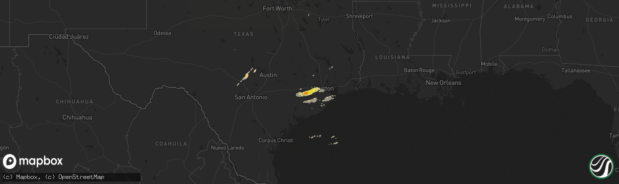
Hail Map on January 9, 2012
The weather event on January 9, 2012 includes Hail map. 1 state and 48 cities were impacted and suffered possible damage. The total estimated number of properties impacted is 63,773.
Want more than just the map?
Turn this storm into a full workflow.
- Owner + property data so you know who to knock
- OnDemand branded weather history reports to win the "did we even have hail?" argument
- RoofTrace estimate so reps stop guessing numbers at the door
Bought this map? Upgrade within 7 days and we'll credit the $230. (10-15 min setup call)
Hail
63,773
Estimated number of impacted properties by a 1.00" hail or larger0
Estimated number of impacted properties by a 1.75" hail or larger0
Estimated number of impacted properties by a 2.50" hail or largerStates Impacted by Hail Map on January 9, 2012
Storm reports
Texas
| Date | Description |
|---|---|
| 01/09/20121:00 PM CST | Law enforcement witnessed touch down near mall of the mainland in texas city. Windows blown out of vehicles in parking lot. Roof of mall damaged. |
| 01/09/201212:55 PM CST | Trees and fences down along westwood loop in la marque texas. Possible tornado. |
| 01/09/201212:55 PM CST | Storm survey rated the damage from a tornado as ef-0. Law enforcement witnessed touch down near mall of the mainland in texas city. Windows blown out of vehicles in par |
| 01/09/201212:39 PM CST | Tree down cemetery road. |
| 01/09/201211:35 AM CST | Two tractor trailers blown over around intersection of 288 and county road 48. Possible tornado. |
| 01/09/201211:34 AM CST | Two empty tractor trailors travelling in opposite directions on 288 were pushed off the road near intersection with cr 48. Drivers reported trucks being pushed and lift |
| 01/09/201211:32 AM CST | Shed destroyed. Top of a rice dryer ripped off and thrown. Tornado rated efo. |
| 01/09/201211:30 AM CST | Roof blown off. Debris in trees. County road 49. Possible tornado. |
| 01/09/201211:15 AM CST | Barn damaged...shed destroyed. Tornado rated ef0. |
| 01/09/20129:40 AM CST | 60 mph wind gust at hcfcd at hwy 290 and loop 610. |
| 01/09/20129:05 AM CST | Roof damage to homes in the mission bend area. Garage doors blown in. Possible tornado. Time estimated. |
| 01/09/20129:05 AM CST | An ef-1 tornado with winds of 95 mph touched down near the intersection of bissonnet street and gains road in mission bend of fort bend county. Several homes were damag |
| 01/09/20128:55 AM CST | A local report indicates 1.00 inch wind near MISSION BEND |
| 01/09/20128:45 AM CST | Trees and power lines down...paddle boat in tree. Witnesses observed funnel cloud over damage area near fm 723 and oak knoll road. Tornado rated ef0. |
| 01/09/20127:57 AM CST | Ping pong size hail in east bernard relayed from hcfcd. |
Cities Impacted by Hail Map on January 9, 2012
- Wallis, TX
- Round Mountain, TX
- Johnson City, TX
- Eagle Lake, TX
- Rosenberg, TX
- Beasley, TX
- Richmond, TX
- Sugar Land, TX
- Fulshear, TX
- East Bernard, TX
- Houston, TX
- Stafford, TX
- Katy, TX
- Angleton, TX
- Fredericksburg, TX
- Stonewall, TX
- Magnolia, TX
- Montgomery, TX
- Dickinson, TX
- Boerne, TX
- Center Point, TX
- Boling, TX
- Rosharon, TX
- Shepherd, TX
- Needville, TX
- Santa Fe, TX
- Alvin, TX
- Horseshoe Bay, TX
- Llano, TX
- Canton, TX
- Wharton, TX
- Texas City, TX
- Guy, TX
- Damon, TX
- El Campo, TX
- Garwood, TX
- Bellaire, TX
- Alleyton, TX
- Comfort, TX
- Sealy, TX
- Freeport, TX
- Clute, TX
- Lake Jackson, TX
- Liverpool, TX
- Hitchcock, TX
- La Marque, TX
- Danbury, TX
- Pledger, TX