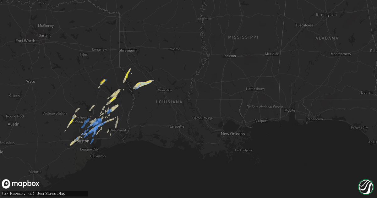
Hail Map in Louisiana on January 8, 2022
Get this storm
January 8 map
$229
one time, instant access
Download today. No call, no setup
Keep the $229
Bought the map and want the full workflow? Apply the entire $229 to a subscription within 7 days. None of it is wasted.
Every map, not just this one
This buys you this map. Subscription and you get every map we run, in the markets you choose from a few cities to whole states to nationwide. Plus real-time alerts the moment a storm fires.
Contact data
Name, contact info, occupancy, even credit band for addresses in the footprint. You go from where it hit to who to call.
Become the source they trust
Unlimited branding weather history reports on demand. You already have the documented answer ready for the property owner, and you are the one who showed up with it.
Property data and RoofTrace estimates
Pull up any address you have got, its value and the exact code rules for that jurisdiction, straight from One Click Code. Then RoofTrace estimates the squares, pitch, and roof value, priced the way you price.
Storm reports in Louisiana
Louisiana
| Date | Description |
|---|---|
| 01/08/20225:33 AM CST | Power lines down and pole snapped so far one tree down across the road at red dirt in southern natchitoches parish around 5:30 am... 5:35 am along with pea to dime size |
| 01/08/20224:53 AM CST | Tornadic debris signature witnessed on kpoe radar beginning with 1053z volume scan timestamp. |
| 01/07/20228:59 PM CST | At 258 PM CST, a severe thunderstorm was located 7 miles north of Converse, or 10 miles south of Mansfield, moving northeast at 50 mph. HAZARD...60 mph wind gusts and quarter size hail. SOURCE...Radar indicated. IMPACT...Hail damage to vehicles is expected. Expect wind damage to roofs, siding, and trees. Locations impacted include... Mansfield, Ringgold, Converse, Oak Grove, South Mansfield, Hall Summit, Carmel, Evelyn, Caspiana, Grand Bayou, Loggy Bayou, Ninock, Pelican, Crichton and Mc Dade. |
Cities Impacted by Hail Map on January 8, 2022
- Lufkin, TX
- Warren, TX
- Fred, TX
- Jasper, TX
- Woodville, TX
- Hillister, TX
- Converse, LA
- Noble, LA
- Milam, TX
- Shelbyville, TX
- Pelican, LA
- Mansfield, LA
- Huntsville, TX
- Zavalla, TX
- Cleveland, TX
- Montgomery, TX
- Hemphill, TX
- Pineland, TX
- Batson, TX
- Hull, TX
- Kountze, TX
- Colmesneil, TX
- Houston, TX
- Plantersville, TX
- Magnolia, TX
- Humble, TX
- Broaddus, TX
- Bronson, TX
- Livingston, TX
- Crosby, TX
- Huffman, TX
- Liberty, TX
- Dayton, TX
- Richmond, TX
- Sugar Land, TX
- Willis, TX
- Florien, LA
- Silsbee, TX
- Saratoga, TX
- Hockley, TX
- Waller, TX
- New Waverly, TX
- Nacogdoches, TX
- Spurger, TX
- Provencal, LA
- Cloutierville, LA
- Natchitoches, LA
- Shepherd, TX
- Hornbeck, LA
- Natchez, LA
- Many, LA
- Lena, LA
- Brookeland, TX
- Nome, TX
- Beaumont, TX
- Devers, TX
- Chester, TX
- Lumberton, TX
- Vidor, TX
- Buna, TX
- La Porte, TX
- Baytown, TX
- Kingwood, TX
- New Caney, TX
- Conroe, TX
- Porter, TX
- Splendora, TX


