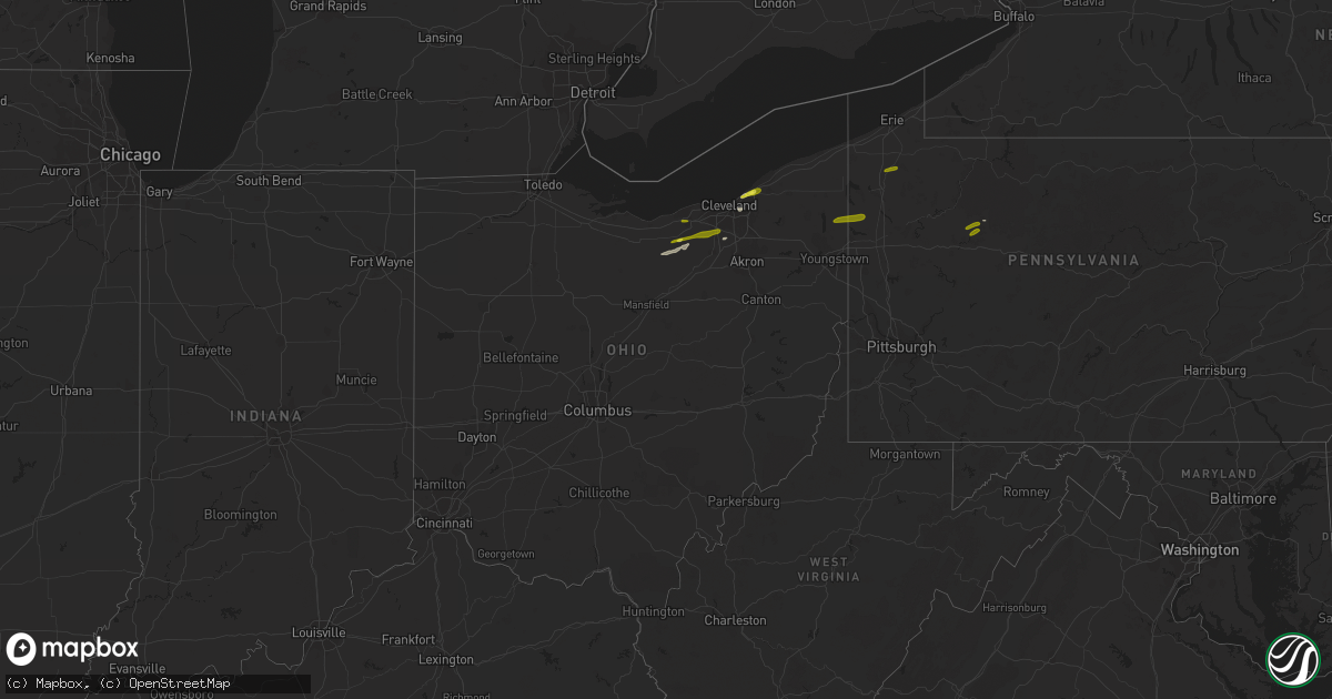
Hail Map in Ohio on January 8, 2019
Get this storm
January 8 map
$229
one time, instant access
Download today. No call, no setup
Keep the $229
Bought the map and want the full workflow? Apply the entire $229 to a subscription within 7 days. None of it is wasted.
Every map, not just this one
This buys you this map. Subscription and you get every map we run, in the markets you choose from a few cities to whole states to nationwide. Plus real-time alerts the moment a storm fires.
Contact data
Name, contact info, occupancy, even credit band for addresses in the footprint. You go from where it hit to who to call.
Become the source they trust
Unlimited branding weather history reports on demand. You already have the documented answer ready for the property owner, and you are the one who showed up with it.
Property data and RoofTrace estimates
Pull up any address you have got, its value and the exact code rules for that jurisdiction, straight from One Click Code. Then RoofTrace estimates the squares, pitch, and roof value, priced the way you price.
Storm reports in Ohio
Ohio
| Date | Description |
|---|---|
| 01/08/20193:25 PM CST | Tree down on quinn road in auburn township. |
| 01/08/20193:22 PM CST | Tree down on music street in russell township. |
| 01/08/20192:57 PM CST | A local report indicates 1.00 inch wind near STRONGSVILLE |
| 01/08/20192:48 PM CST | Tree down on stone road in newbury township. |
| 01/08/20192:30 PM CST | Reported via twitter with a picture. |
| 01/08/20192:27 PM CST | Report taken from twitter. |
| 01/08/20192:26 PM CST | A local report indicates 1.25 inch wind near 2 NE RICHMOND HEIGHTS |
| 01/08/20192:20 PM CST | A local report indicates 1.00 inch wind near ELYRIA |
| 01/08/20191:50 PM CST | A local report indicates 1.00 inch wind near 1 SW BELLEVUE |
| 01/08/20199:20 AM CST | ***preliminary*** structural damage has occurred to an outhouse building in cortland just east of mosquito lake. Trees and wires have been downed in other locations. A |
| 01/08/20194:43 AM CST | At 1043 AM EST, a severe thunderstorm was located near Sharpsville, moving east at 35 mph. HAZARD...60 mph wind gusts and quarter size hail. SOURCE...Radar indicated. IMPACT...Minor damage to vehicles is possible. Expect damage to trees and power lines. Locations impacted include... Orangeville, Yankee Lake and Brookfield Center. |
| 01/08/20192:21 AM CST | At 820 AM EST, severe thunderstorms were located along a line extending from 6 miles east of Wakeman to near Wellington to near New London, moving east at 45 mph. HAZARD...60 mph wind gusts and quarter size hail. SOURCE...Radar indicated. IMPACT...Minor damage to vehicles is possible. Expect damage to trees and power lines. Locations impacted include... Elyria, Medina, Brunswick, North Ridgeville, Grafton, Wellington, Chippewa Lake, Broadview Heights, Olmsted Falls, Eaton, Oberlin, Hinckley, Lagrange, Penfield, Pittsfield, Spencer, Gloria Glens Park, Kipton, Rochester and Chippewa-On-The-Lake. |
| 01/07/20199:44 PM CST | At 344 PM EST, a severe thunderstorm was located over Grafton, or 8 miles southeast of Elyria, moving east at 45 mph. HAZARD...60 mph wind gusts and quarter size hail. SOURCE...Radar indicated. IMPACT...Minor damage to vehicles is possible. Expect damage to trees and power lines. Locations impacted include... Cleveland, Parma, Lakewood, Euclid, Cleveland Heights, Strongsville, Brunswick, North Royalton, Solon, Hudson, Twinsburg, Streetsboro, Warrensville Heights, Macedonia, Highland Hills, North Olmsted, Garfield Heights, Shaker Heights, Maple Heights and South Euclid. |
| 01/07/20199:39 PM CST | At 339 PM EST, a severe thunderstorm was located near Newton Falls, or 8 miles west of Warren, moving east at 40 mph. HAZARD...60 mph wind gusts and quarter size hail. SOURCE...Radar indicated. IMPACT...Minor damage to vehicles is possible. Expect damage to trees and power lines. Locations impacted include... Warren, Niles, Hubbard, Cortland, Newton Falls, Lordstown, Garrettsville, Kinsman, Vienna Center, Hilltop, Maplewood Park, Bristolville, Leavittsburg, Girard, Vienna, McDonald, Mecca, Windham, Johnston and Orangeville. |
| 01/07/20199:37 PM CST | At 336 PM EST, a severe thunderstorm was located near Willoughby, or near Willowick, moving east at 50 mph. HAZARD...60 mph wind gusts and quarter size hail. SOURCE...Radar indicated. IMPACT...Minor damage to vehicles is possible. Expect damage to trees and power lines. Locations impacted include... Painesville, Willowick, Chardon, Fairport Harbor, Mentor, Willoughby, Eastlake, Madison, Perry, Timberlake, Lakeline, Chesterland, Wickliffe, Richmond Heights, Willoughby Hills, Highland Heights, Mentor-On-The-Lake, Kirtland, Huntsburg and Mayfield. |
| 01/07/20199:27 PM CST | At 326 PM EST, a severe thunderstorm was located over Barberton, or near Akron, moving east at 45 mph. HAZARD...60 mph wind gusts and quarter size hail. SOURCE...Radar indicated. IMPACT...Minor damage to vehicles is possible. Expect damage to trees and power lines. Locations impacted include... Akron, Ravenna, Cuyahoga Falls, Kent, Barberton, Green, Tallmadge, Mogadore, Stow, Norton, Brimfield, Fairlawn, Randolph, Munroe Falls, Lakemore, Silver Lake, Brady Lake, Portage Lakes, Pigeon Creek and Montrose-Ghent. |
| 01/07/20199:22 PM CST | At 321 PM EST, severe thunderstorms were located along a line extending from Elyria to near Wellington, moving east at 20 mph. HAZARD...60 mph wind gusts and quarter size hail. SOURCE...Emergency management. IMPACT...Minor damage to vehicles is possible. Expect damage to trees and power lines. Locations impacted include... Cleveland, Lorain, Elyria, Medina, Lakewood, Strongsville, Brunswick, Westlake, North Ridgeville, Avon Lake, Amherst, Grafton, Wellington, Chippewa Lake, North Olmsted, Avon, Rocky River, Brook Park, Berea and Fairview Park. |
| 01/07/20198:48 PM CST | At 247 PM EST, a severe thunderstorm was located 7 miles south of Green Springs, or 8 miles east of Tiffin, moving east at 45 mph. HAZARD...60 mph wind gusts and penny size hail. SOURCE...Radar indicated. IMPACT...Expect damage to trees and power lines. Locations impacted include... Norwalk, Bellevue, Green Springs, Milan, Northern Milan, Bloomville, Monroeville, Republic, Flat Rock and Bloomingville. |
All States Impacted by Hail Map on January 8, 2019
Cities Impacted by Hail Map on January 8, 2019
- Oberlin, OH
- Lagrange, OH
- Wellington, OH
- Willoughby, OH
- Wickliffe, OH
- Cleveland, OH
- Euclid, OH
- Hinckley, OH
- Grafton, OH
- New London, OH
- Beachwood, OH
- Marienville, PA
- Venango, PA
- Cambridge Springs, PA
- Saegertown, PA
- Strattanville, PA
- Sigel, PA
- Lucinda, PA
- Leeper, PA
- Vowinckel, PA
- Cooksburg, PA
- Elyria, OH
- North Royalton, OH
- Valley City, OH
- Columbia Station, OH
- Brunswick, OH
- Strongsville, OH
- Farmdale, OH
- Fowler, OH
- Kinsman, OH
- Greenville, PA
- Burghill, OH


