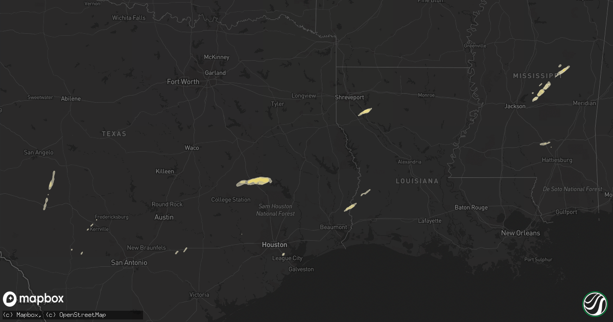
Hail Map in Mississippi on January 8, 2012
Get this storm
January 8 map
$229
one time, instant access
Download today. No call, no setup
Keep the $229
Bought the map and want the full workflow? Apply the entire $229 to a subscription within 7 days. None of it is wasted.
Every map, not just this one
This buys you this map. Subscription and you get every map we run, in the markets you choose from a few cities to whole states to nationwide. Plus real-time alerts the moment a storm fires.
Contact data
Name, contact info, occupancy, even credit band for addresses in the footprint. You go from where it hit to who to call.
Become the source they trust
Unlimited branding weather history reports on demand. You already have the documented answer ready for the property owner, and you are the one who showed up with it.
Property data and RoofTrace estimates
Pull up any address you have got, its value and the exact code rules for that jurisdiction, straight from One Click Code. Then RoofTrace estimates the squares, pitch, and roof value, priced the way you price.
Storm reports in Mississippi
Mississippi
| Date | Description |
|---|---|
| 01/08/20124:00 PM CST | Reported at the intersection of highway 49 and cold springs road. |
| 01/07/201210:10 PM CST | Scattered trees blown down throughout town. A few instances of trampolines blown up into trees noted. |
| 01/07/20129:55 PM CST | Numerous trees down and minor damage to 3 mobile homes just south of the winston and neshoba county line around county road 187 |
| 01/07/20129:50 PM CST | Trees down along county rd 185 near arlington. Power out along county rd 187. |
| 01/07/20129:06 PM CST | Trees down along highway 488 near freeny |
| 01/07/20128:50 PM CST | A local report indicates 1.00 inch wind near LENA |
| 01/07/20128:50 PM CST | Roof partially blown off a house. Metal on power lines in the city of lena. |
| 01/07/20128:25 PM CST | Trees and power lines down along denson rd...measels rd and fairchilds rd |
All States Impacted by Hail Map on January 8, 2012
Cities Impacted by Hail Map on January 8, 2012
- Noxapater, MS
- Friendswood, TX
- Houston, TX
- Webster, TX
- Seminary, MS
- Eldorado, TX
- Menard, TX
- Waelder, TX
- Lena, MS
- Hempstead, TX
- Ringgold, LA
- Coushatta, LA
- Starks, LA
- Merryville, LA
- Call, TX
- Carthage, MS
- Midway, TX
- Shreveport, LA
- Sonora, TX
- Deweyville, TX
- Pelahatchie, MS
- Morton, MS
- Hunt, TX
- Madisonville, TX
- Trinity, TX
- Huntsville, TX
- Lovelady, TX
- Collins, MS
- Louisville, MS
- Philadelphia, MS
- Ingram, TX
- Harper, TX
- Forest, MS
- Walnut Grove, MS
- Deridder, LA
- Mansfield, LA
- Paint Rock, TX
- Harwood, TX
- Gonzales, TX
- North Zulch, TX
- Buna, TX
- Utopia, TX
- McCool, MS
- Fredericksburg, TX
- Rio Frio, TX


