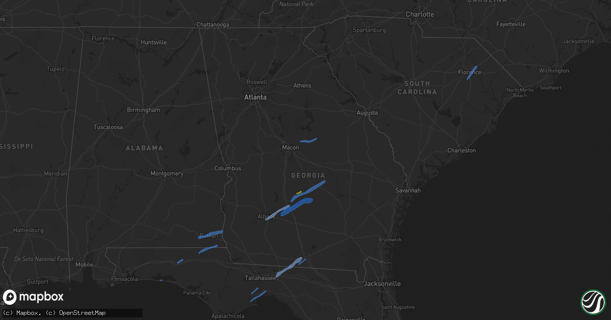
Hail Map in Georgia on January 2, 2022
Get this storm
January 2 map
$229
one time, instant access
Download today. No call, no setup
Keep the $229
Bought the map and want the full workflow? Apply the entire $229 to a subscription within 7 days. None of it is wasted.
Every map, not just this one
This buys you this map. Subscription and you get every map we run, in the markets you choose from a few cities to whole states to nationwide. Plus real-time alerts the moment a storm fires.
Contact data
Name, contact info, occupancy, even credit band for addresses in the footprint. You go from where it hit to who to call.
Become the source they trust
Unlimited branding weather history reports on demand. You already have the documented answer ready for the property owner, and you are the one who showed up with it.
Property data and RoofTrace estimates
Pull up any address you have got, its value and the exact code rules for that jurisdiction, straight from One Click Code. Then RoofTrace estimates the squares, pitch, and roof value, priced the way you price.
Storm reports in Georgia
Georgia
| Date | Description |
|---|---|
| 01/02/20224:29 PM CST | Trees and powerlines down. Damage to 1 home. |
| 01/02/20224:25 PM CST | Power lines down and some structural damage to out buildings and a shop in nw ben hill county in vicinity of sweet pea and salem church road. |
| 01/02/20224:12 PM CST | A few trees down along waterloo-rebecca rd. |
| 01/02/20223:20 PM CST | Tree down onto powerline multiple locations where traffic lights are out due to power outages in albany. |
| 01/02/20221:50 PM CST | Tree down on martin rd. |
| 01/02/20227:55 AM CST | Trees and powerlines down along with some tops of trees twisted or snapped. Tin roof blown off storehouse. |
| 01/02/20225:20 AM CST | At 1120 PM EST, a severe thunderstorm was located near Baxley, moving northeast at 40 mph. HAZARD...60 mph wind gusts. SOURCE...Radar indicated. IMPACT...Expect damage to roofs, siding, and trees. Locations impacted include... Baxley, Plant Hatch and Pine Grove. |
| 01/02/20224:09 AM CST | At 1009 PM EST, severe thunderstorms were located along a line extending from 6 miles north of Monticello to 14 miles southeast of St. Marks, moving northeast at 30 mph. HAZARD...60 mph wind gusts. SOURCE...Radar indicated. IMPACT...Expect damage to roofs, siding, and trees. Locations impacted include... Monticello, Perry, Madison, Greenville, Lee, Alma, Pinland, Jug Island, Pinetta, Drifton, Scanlon, Lovett, Foley, Hanson, Perry-Foley Airport, Hampton Springs, Iddo, Moseley Hall, Secotan and Boyd. |
| 01/02/20224:05 AM CST | At 1004 PM EST, severe thunderstorms were located along a line extending from near Santa Claus to 7 miles east of Plant Hatch to near Baxley, moving northeast at 70 mph. HAZARD...60 mph wind gusts. SOURCE...Radar indicated. IMPACT...Expect damage to trees and powerlines. Locations impacted include: Reidsville, Glennville, Collins, Manassas, Gordonia Altamaha State Park and Mendes. |
| 01/02/20223:38 AM CST | At 937 PM EST, severe thunderstorms were located along a line extending from near Hazlehurst to near Douglas, moving east at 25 mph. HAZARD...60 mph wind gusts and penny size hail. SOURCE...Radar indicated. IMPACT...Expect damage to roofs, siding, and trees. Locations impacted include... Douglas, Baxley, Hazlehurst, Alma, Pearson, Willacoochee, Broxton, Graham, Surrency and Plant Hatch. |
| 01/02/20223:09 AM CST | At 909 PM EST, severe thunderstorms were located along a line extending from 6 miles north of Alapaha to 12 miles south of Cairo, moving east at 20 mph. HAZARD...60 mph wind gusts. SOURCE...Radar indicated. IMPACT...Expect damage to roofs, siding, and trees. Locations impacted include... Nashville, Adel, Thomasville, Quitman, Valdosta, Hahira, Sparks, Boston, Enigma, Lenox, Alapaha, Pavo, Coolidge, Morven, Berlin, Barwick, Cecil, Ellenton, Reed Bingham State Park and Dillon. |
| 01/02/20221:38 AM CST | At 738 PM EST/638 PM CST/, severe thunderstorms were located along a line extending from 7 miles east of Chattahoochee to near Mexico Beach, moving east at 30 mph. HAZARD...60 mph wind gusts. SOURCE...Radar indicated. IMPACT...Expect damage to roofs, siding, and trees. Locations impacted include... Midway, Quincy, Blountstown, Havana, Port St. Joe, Mexico Beach, Greensboro, Stonemill Creek, Chattahoochee, Tyndall Air Force Base, Orange, Wewahitchka, Gretna, Bristol, Rock Bluff, Honeyville, Juniper, Douglas City, Abe Springs and Allanton. |
| 01/01/202211:23 PM CST | At 522 PM EST, a severe thunderstorm was located over Antioch Church, or near Abbeville, moving northeast at 45 mph. HAZARD...60 mph wind gusts and nickel size hail. SOURCE...Radar indicated. IMPACT...Expect damage to roofs, siding, and trees. Locations impacted include... McRae, Eastman, Abbeville, Alamo, Helena, Milan, Rhine, Scotland, Chauncey, Cedar Grove, Antioch Church, Jay Bird Springs, Temperance, Browning, Five Points, Achord, Little Ocmulgee State Park and Godwinsville. |
| 01/01/202210:27 PM CST | At 427 PM EST, severe thunderstorms were located along a line extending from 6 miles southeast of Desoto to Putney, moving northeast at 55 mph. HAZARD...60 mph wind gusts. SOURCE...Radar indicated. IMPACT...Expect damage to roofs, siding, and trees. Locations impacted include... Fitzgerald, Sylvester, Putney, Ashburn, Albany, Poulan, Marine Corps Logistics Base, Turner City, Worth, Terrell, Sycamore, Sumner, Warwick, Rebecca, Stocks, Amboy, Sylvester Airport, Waterloo, Inaha and Red Rock. |
| 01/01/202210:26 PM CST | At 426 PM EST, a severe thunderstorm was located near Cedar Creek, or 7 miles west of Abbeville, moving northeast at 45 mph. HAZARD...60 mph wind gusts and quarter size hail. SOURCE...Radar indicated. IMPACT...Hail damage to vehicles is expected. Expect wind damage to roofs, siding, and trees. Locations impacted include... Eastman, Abbeville, Pineview, Rhine, Chauncey, Union, Dubois, Gresston, Plainfield, Empire, Yonkers, Cedar Creek, Roddy, Pope City, Ocmulgee Banks, Finleyson, Jay Bird Springs, Five Points, Achord and Godwinsville. |
| 01/01/202210:08 PM CST | Several reports of trees and powerlines down in lowndes county. |
| 01/01/202210:04 PM CST | At 404 PM EST, a severe thunderstorm was located near Doles, or 9 miles west of Ashburn, moving northeast at 45 mph. HAZARD...60 mph wind gusts and penny size hail. SOURCE...Radar indicated. IMPACT...Expect damage to roofs, siding, and trees. Locations impacted include... Cordele, Rochelle, Arabi, Pitts, East Crisp, Antioch Church, Seville, Hatley, Pleasant View, Double Run, Tremont, Wenona and Owensboro. |
| 01/01/20229:32 PM CST | At 332 PM EST, a severe thunderstorm was located near Putney, moving northeast at 35 mph. HAZARD...60 mph wind gusts. SOURCE...Radar indicated. IMPACT...Expect damage to roofs, siding, and trees. Locations impacted include... Putney, Albany, Sylvester, East Albany, Marine Corps Logistics Base, Turner City, Terrell, Stocks, Radium Springs, Lockett Crossing, Sylvester Airport, South Albany, Southwest Ga Regional A/P, Pecan City, Red Rock, Acree, Gammage, Shingler, Williamsburg and Isabella. |
| 01/01/20229:25 PM CST | A couple of trees down near ricardo st and along county farm road. Time estimated by radar. |
| 01/01/20229:11 PM CST | The tattnall county warning point reported a tree down near the intersection of dl durrence road and rod strickland road. |
| 01/01/20228:40 PM CST | Powerlines down outside of hazlehurst. Time estimated by radar. |
| 01/01/20228:34 PM CST | At 233 PM EST, a severe thunderstorm was located near Webb, or 7 miles east of Headland, moving east at 45 mph. HAZARD...60 mph wind gusts. SOURCE...Radar indicated. IMPACT...Expect damage to roofs, siding, and trees. Locations impacted include... Blakely, Arlington, Douglasville, Centerville, Damascus, Rock Hill, Colomokee, Cuba, Ferrell Crossroads, Early Co A/p, Old Damascus, Hentown, Kolomoki Mounds Sp, Hilton, Rowena and Sawhatchee. |
| 01/01/20228:27 PM CST | At 227 PM CST, severe thunderstorms were located along a line extending from near Cottonwood to 10 miles south of Vernon, moving east at 30 mph. HAZARD...60 mph wind gusts. SOURCE...Radar indicated. IMPACT...Expect damage to roofs, siding, and trees. Locations impacted include... Marianna, Chipley, Bradford, Malone, Cottondale, Grand Ridge, Greenwood, Altha, Alford, Wausau, Campbellton, Bascom, Moose Pond, Camps Head, Lovedale, Dellwood, Porter Lake, Ellaville, Buena Vista and Chipley Municipal Airport. |
| 01/01/20228:15 PM CST | A few trees and powerlines down in thomasville. |
| 01/01/20227:16 PM CST | At 116 PM CST, a severe thunderstorm was located over Dothan, moving east at 55 mph. HAZARD...60 mph wind gusts. SOURCE...Radar indicated. IMPACT...Expect damage to roofs, siding, and trees. Locations impacted include... Headland, Dothan, Taylor, Midland City, Kinsey, Ashford, Cowarts, Webb, Columbia, Pinckard, Rehobeth, Grimes, Avon, Napier Field, Haleburg, Memphis, Sigma, Grandberry Crossroads, Enon and Wilson Mill. |
| 01/01/20226:00 PM CST | Homes damaged. Fire station number 1 destroyed. Possible tornado. |
All States Impacted by Hail Map on January 2, 2022
Cities Impacted by Hail Map on January 2, 2022
- Effingham, SC
- Florence, SC
- Rochelle, GA
- Abbeville, GA
- Crawfordville, FL
- Sopchoppy, FL
- Saint Marks, FL
- Quitman, GA
- Greenville, FL
- Monticello, FL
- Lamont, FL
- Valdosta, GA
- Destin, FL
- Ponce De Leon, FL
- Defuniak Springs, FL
- Gordon, AL
- Graceville, FL
- Cottonwood, AL
- Campbellton, FL
- Oakfield, GA
- Ashburn, GA
- Warwick, GA
- Albany, GA
- Sylvester, GA
- Cordele, GA
- Alamo, GA
- Milan, GA
- McRae Helena, GA
- Rhine, GA
- Arabi, GA
- Chauncey, GA
- Eastman, GA
- Pitts, GA
- Cadwell, GA
- Sycamore, GA
- Fitzgerald, GA
- Rebecca, GA
- Poulan, GA
- Sumner, GA
- Sandersville, GA
- Macon, GA
- Gordon, GA
- Milledgeville, GA
- McIntyre, GA
- Haddock, GA
- Vidalia, GA
- Blakely, GA
- Hartford, AL
- Slocomb, AL
- Ashford, AL
- Headland, AL
- Columbia, AL
- Newton, AL
- Dothan, AL
- Cowarts, AL
- Webb, AL


